Tar Balls found in Florida Keys; Tuesday Conference Call with NOAA Regarding possibility of oil entering Loop Current
Posted by Gail the Actuary on May 18, 2010 - 12:36pm
I listened to a press conference with NOAA administrators this morning regarding the possibility of oil from the oil spill getting into the Loop Current. Some of the takeaways from the press conference:
1. While tar balls have been found in the Florida Keys, test have not yet been performed to determine whether they are from BP's oil spill. They might be from another source.
2. Any oil that does get into the Loop Current will be very dilute and weathered, by the time it gets to Florida. If oil does go this far, tar balls would be typical of the kind of hydrocarbons one would expect, by the time the oil gets this far.
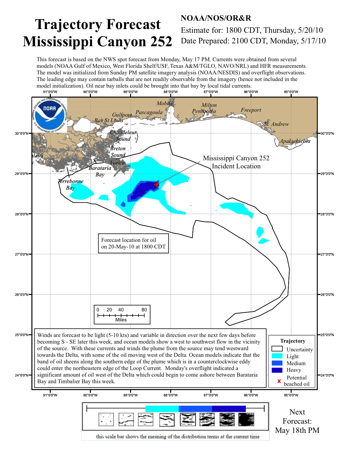
3. The vast majority of the oil in the oil slick is "dozens of miles" from the Loop Current. What is relatively close is the very tip of a tendril of light oil slick extending to the south. According to a map on the NOAA website (shown below the fold), "Ocean models indicate that the band of oil sheens along the souther edge of the plume which is in a counterclockwise eddy could enter the northeastern edge of the Loop Current."
4. The exact location of the oil slick and of the Loop Current changes over time. NOAA is doing additional monitoring tests, to try to determine with more precision how far apart the tip of the oil slick is from the Loop Current.
5. The behavior of the Loop Current varies at different depths. The top layer seems to moves faster than the lower layers. Based on the speed of the top layer, if oil enters the oil slick, it would take 8 to 10 days to travel to the Florida Keys. During this time, the oil would continue to evaporate and weather, reducing the amount of oil getting to Florida, and changing its nature.
6. Samples of water from the underwater "plumes" have been taken by the Pelican research ship. These samples have been divided and sent to testing centers, but no results are yet available.
7. New fishery closures are being announced today. The total proportion closed now amounts to 19% of federal waters in the Gulf of Mexico. NOAA is also starting a new seafood sampling plan.
8. The NOAA Website shows the following forecast for the oil slick for Thursday. (Click for larger image).
Edit
The Wall Street Journal has a good image of the current and oil slick:
Tar Balls found in Florida Keys; Tuesday Conference Call with NOAA Regarding possibility of oil entering Loop Current
PDF version
144 comments
Tar Balls found in Florida Keys; Tuesday Conference Call with NOAA Regarding possibility of oil entering Loop Current
PDF version
144 comments
Contact
- Content: editors at theoildrum dot com
- Tech support: support at theoildrum dot com
License

This work is licensed under a Creative Commons Attribution-Share Alike 3.0 United States License.
Image of the Day: BP / Gulf oil spill - Slick entrained in Loop Current
This site, Skytruth, has all the images since the beginning of the oil spill
http://www.flickr.com/photos/skytruth/
This site, Skytruth, has all the images since the beginning of the oil spill
http://www.flickr.com/photos/skytruth/
Forgive me if my question seems out of place, I have been reading your post here at the Oil Drum and have not found an answer to this question, so I put it straight to you now.
Why didn't BP blowup the well head at the sea floor with a bomb? It seems like bombing an out of control wells is a technique used in the past very successfully. Was the reason because it would have made this well unusable in the future hence a financial loss for BP? How much money do you think BP had invested in this well before the accident?
Thanks for all your excellent analysis of this on going tragedy.
Are you thinking about cases with burning surface wells? The explosion depletes the oxygen and snuffs out the fire. It does not stop the flow.
I was thinking of surface wells, thanks for clarifying that. I was also thinking that the pipe down is over 10,000 feet below the seabed and they should be able to implode it with 100's of tons of debris if they bomb it at the sea floor. Am I way off base in my assumptions? (Would not be the first time)
Sparky -- it' difficult for folks to imagine the sea floor condition out there. Most think in terms of rocks. No rocks out there. It's essentially soft muck for a couple of thousands of feet. Think in terms of a big bowl of pudding you stick a straw in it and blow air. Bubbles right up. Now imagine putting flat piece of anything where the air was bubbling up. Will that stop the air from popping up? Nope...will just go round the block and bubble up elsewhere. That's about the best analogy I can come up with.
Hemipelagic sediments?
A very little SA but mostly just very fine clay from the Miss. River over the ages.
From what I have read about similar occurrences of blowouts, the wells had collapsed into themselves at some depth and thus shut down the flow automatically. Apparently in this recent incident the highly reinforced casing prevented a collapse.
So the question remains, can enough energy be created and directed against the casing at some depth that will stop the flow to the floorbed above? How deep would we have to drill to place such a charge? What type of charge would accomplish this in the least time and with least risk and side-effects (radiation, creating a larger leak)?
(Non-technical aside: Could we possibly find better, even productive, uses for bunker busters and tactical nuclear devices than killing our brothers overseas, or are these for Politician Use Only??)
Red -- What you're describing is exactly what the relief well will do. Except instead of an explosive charge they'll drill through the casing with a mill bit and then pump heavy mud into the wild well to kill the flow. A much more predictable approach. They have to drill almost to the depth of the flowing reservoir because of the pressure differences in the different rock layers.
Do you mean to tell me that they have such a precise control over the drilling bit that they can hit the old pipe from the side??
Damn.
in fact they do. I believe HO or Rockman have authored a few posts about the directional drilling that they can do in this relief well.
Slatz
ericy -- Only if you have a pretty good fix on the target. But they survey the location of the original hole as it was drilled. The directional control can get you within 10's of feet. From that distance there are electronic sensors behind the bit that can guide it in. Doesn't always hit the first time but will eventually. But a very slow process at the very end.
So there is a time penalty for precision. I suppose it is case specific but would the final stage be 20% of the overall drill time?
Difficult to guess dissy. But if you miss by a couple of feet it's not just a matter of backing up 10 or 20 feet and starting over. They might have to pull back up a couple of hundred feet, set a cmt plug and start drilling again very slowly. Might take a week or more to make the correction.
It's like trying to thread a needle without your glasses.
I say if you're within a few feet, pump the bottom of the new hole full of anfo, set a plug and pull the trigger! The ultimate junk shot.
Problem with that is, you could frac into the formation.
Then your relief well could be a second gusher. That's why all this stuff takes so long.
Ghung -- could work like that on an open hole blow out but remember they have steel casing protecting the flow. Need to mill through it before they can pump a kill pill. Makes then intersect effort about as difficult as it can get: not only do they have to hit a target less than 10" in diameter about 19,000' away they also have to get the mill to cut the round sided csg and not slip off around it. Can be done but it can be a very, very slow process.
Rockman: if you are listening thanks for your effort that you have made on this site. These are tough concepts to explain.
I have seen minimimum specific information on the first relief well except for what is in the schematic drawing. I have no "inside" information and like Rockman am plenty busy dealing with ny own task at hand.
The original wellbore was surveyed most likely at appoximate 30 foot survey stations. Possibly 90 foot survey stations since the rig had a top drive and drilled (3)30 foot joints for a "stand" down. The survey would have been taken with a Measurement While Drilling system that would have been located in the "bottom hole assembly" or BHA. The survey instrument is composed of accelerometers and magnetometers and transmits this information by pressure pulses through the mud system.
Each type of downhole tool has an error factor or accuracy. The existing wellbore will have an "ellipse of uncertainty" which may be one or two diameters of the casing depending on the tool in which the surveys were originally measured. A well plan has been designed to intersect the existing well bore- a rough idea is on the BP schematic view. My guess is that at the present time they are using rotary steerables (the directional company is not known) which should have inclination at the bit and they should be able to "paint the line" in terms of accuracy for most of the relief well. The later stages of the operation is where things will get critical.
The best way, from what I understand,is to use a magnetic ranging system. These have been used since the late 1960's A low frequencey EM field is transmitted through the existing casing . I don't know if anyone had the foresight to design one that can operate under 5,000 feet of water. The distance and direction of the well bore can be calculated from the induced field strength relative to the magnetometers in the MWD system in the relief well.
My guess is that when they finally approach within a few feet of the existing cased hole (condition of which is unknown) that they will remove all nonessential personnel and mill into the well and use a kill mud. Rockman may be able to confirm but the original mud weight (14.5 ppg from what I understand) should be sufficient. Fracture gradient there is probably known so they should know what the maximum weight is. They will then mill into the casing during daylight hours - take the intial kick, and then kill the well.
Should they miss -a cement plug and sidetrack will have to be set which presents a separate set of problems so lets pray they hit it first time. The "time penalty" would be high but it is not practical to assign a percentage.
The intensity and stress levels among personnel is probably extremely high. I don't envy the directional drillers, or crew on this project.
Such a ranging system should be familiar to anyone who has seen pipe and wire locating work done in their yard. It's a little different than a metal detector. I helped engineer an early variant of today's digital-algorithm type of locators.
If the theory is similar, distance from the pipe can be gleaned as well as sideways offset, but which side off-center is hard to determine (delay paths are the same on either side of the well bore). You have to have motion from side to side to determine which, but that can be accomplished by performing successive measurements while intentionally moving the bore path.
You can do the same sort of thing passively, like a metal detector, but it's harder to get the same accuracy. Since here the contents of the well should be accurately known, and the density and type of the rock, the active system should work well.
I imagine Rockman could further explain how they make the final refinements, but I imagine they know pretty closely where they are, and a hit or miss is probably determined as much by vagaries of how the bit steers as it is by mis-locating the target.
Yes it is similar in concept to cable/pipeline locating. As you are aware the quality of the locate has a lot to do with the ground characteristics. Inducing a signal is the least accurate. Lets hope this was anticipated by Vector Magnetics or whoever provides the ranging service for deepwater application.
In this application the "receiver" is the conventional MWD and the X,Y, Z axis magnetometers. The field strength allows calculation of "high side" relative to the target.
My guess is that the final foot or so will be "time drilled" with ditch magnets in the possum belly and be looking for mill cuttings if they decide to circulate out. The first indicator will be an increase in torque as they intersect the existing wellbore. In my mind there is possibility that the casing has collapsed or some joints dislodged uphole. This will be no slam-dunk.
Nothing to add...you guys laid it out quit well.
details, case histories of intersecting wells in these two links:
http://www.jwco.com/technical-litterature/p11.htm
http://www.vectormagnetics.com/Relief%20Well%20Services.htm
Vector Magnetics would probably be the supplier of the magnetic ranging system. I am aware of the applications on SAG-D wells although I have not personally used them. Whether there is a transmitter available for the pressures of the sea floor and the associated electrode to be set by ROV's- I guess that we will see. It may be practical to attach it directly to the BOP. The signal strength may be an issue in this application. As I said, I hope someone had the foresight to engineer this beforehand. My guess it that whoever knows the answer to these questions is very busy right now.
No mention of the lack of resources devoted to track the undersea plume.
The one NOAA ship in the Gulf was pulled out on May 10th according to post here.
http://www.theoildrum.com/node/6478#comment-625321
The Pelican apparently acted on it's own but reports stated that their request for funding for more sampling has not yet been meet.
Other university owned oceanographic vessels (Texas A&M has one for example) have not been deployed.
Alan
Jane Lubchenko of NOAA started out by making a fairly long statement, and ended with another statement. Basically, she and the other NOAA people came across as saying, "The situation isn't all that bad. We have things under control. There are a number of statements in the press right now about the undersea plumes and about tar balls in Florida, but we don't yet have any studies to confirm these stories are true."
Unless members of the press asked very direct questions, I don't think any negative information would come out. Even then, I think NOAA representatives would try to phrase the answers as positively as possible.
If I attend another press conference with the same folks, perhaps I can try to ask a question about funding for more sampling.
Gail -
It appears to me that what we have going on here is a pretty slick (pun intended) PR damage control effort intended to prevent the BP oil release from becoming the Obama administration's Katrina.
The less serious the release is made to appear, the sooner the American people's attention will move on to something else, and the less heat Obama will have to face. Thus, the Obama administration and BP appear to have the same goal: control and limit all quantitative information about the size of the release, downplay the seriousness of the impact, while accentuating how hard everyone involved is trying to solve the problem. The message: don't worry, everything is going to be OK.
If indeed the government only has a single boat out there conducting sampling of an area larger than many states, then that tells me they are not very interested in knowing how bad it really is. Ditto for BP, who has in so many words said that it is not interested in estimating the size of the release, ostensibly because it needs to focus on fixing the problem (as if the two were mutually exclusive). This is somewhat analogous to having a major pandemic that kills untold thousands of people yet having the government refusing to count the victims because it might be too upsetting and make the government look bad.
Dmitry Orlov calls this America's Chernobyl, which fits better than "Katrina" since the former is a man-made disaster, and the later a natural event.
Which oil spill in the past could be fairly compared to what happened in Chernobyl? I don't think you can compare radioactive contamination with petroleum contamination. Your street is bound with the stuff, are you afraid of it?
(with apologies, but it's my favourite gag......)
Q: Why should you never wear Ukranian underpants?
A: Cheernobyl fallout
Regards Chris
"with apologies, but it's my favourite gag"
My nob?
Why thank you.
The workers who wheeled barrows of sand up the reactor dome/roof to dump on the on the burning reactor core were given essentially lead underwear for protection. Needless to say, most, if not all of these people died shortly after. Many volunteered knowing the risk.
Great book with stories/first hand accounts:
http://www.amazon.com/Voices-Chernobyl-History-Nuclear-Disaster/dp/03124...
Much of the exclusion zone is now a semi-wild forest with a few 'hot' zones where the fallout from the plume was particularly concentrated or where they buried or left the equipment that was used to put out the fire.
I had a colleague who studied the effect of radiation on the surrounding forests. He died about 7 years after the accident.
That was truly a disaster of lasting epic proportions, and I wouldn't place this accident with petroleum in the same category. No question, it's a short term environmental disaster, but (fingers crossed) I don't think it'll have lasting effects on the environment. I've been searching around the net for any information on the long term effects of oil spills, including the effects in Prince William Sound, Santa Barbara, and in the Persian Gulf. I haven't found any credible scientific evidence that it creates long term environmental problems. Again, I hope that dispersants, or the physics involved, because this is originating in very deep water as opposed to other historical spills, makes this accident any different for the long term.
The herring fishery in Prince William Sound was destroyed by the Exxon Valdez spill. It was the most profitable fishery in the sound. It no longer exists.
That qualifies as a long term environmental and economic problem.
EDIT: I have to also point out that "it no longer exists" is a lie. Try not to use hyperbole in a debate.
Basic tenet in scientific research: Correlation does not equal causation. The Price William Sound Pacific herring fishery was up for three years following the Valdez disaster before it went down, and the Pacific herring fishery also went down in waters north of Valdez that were not affected by the disaster. There is no valid scientific proof that the change in the Pacific herring fishery was due to the oil spill, and unless you can prove that the oil spill affected kelp growth, or other vegetation that herring spawn on, for the long term, you may not find a link of the oil spill to Pacific herring decline. Pacific herring spawn on kelp. It's considered a delicacy to local natives, and in Japan, among other places, and in itself was a popularly harvested local product. It may well have been over harvested, as has been the case with so many fisheries.
Definitive answers to the herring problem in Prince William Sound have yet to be established. However, it does give us an idea as to the complexity of the long term issues and the need for dedicated scientists and others to insure BP meets their short term, mid term, and long term obligations, even if it takes ten years or more to establish cause and effect.
Whales suspect in struggles of Prince William Sound herring
It will. We don't know how many endangered species will go extinct ...
Ad ignorantiam is not a valid argument.
Oh yes, the wise one, who "knows" this will have no long term impact.
The fact is - species lost - will be lost forever.
Sorry, but that's not a valid argument, either, and don't get me wrong, I'm not saying that this disaster isn't something minor, but I do believe it's being blown out of proportion in some ways. This may be a disaster in the short term, but it remains to be seen just how bad the short term damage will be, and as far as long term damage, it's never happened from a petroleum spill in the ocean. There are some firsts to this spill, (massive use of dispersants - great depth), so maybe there are some unknowns with regards to that, but past spills haven't left any proven long term, widespread, environmental damage.
I used to box in the Navy. I didn't have any "scientific evidence" as to why I had headaches for three days after a good bout. I suppose it could have been due to "barometric sinus imbalance" or something.
"I haven't found any credible scientific evidence that it creates long term environmental problems."
It seems you didn't look very hard:
http://www.evostc.state.ak.us/Universal/Documents/Publications/IHRP%20-%...
Plenty more here:
http://www.pwsherringportal.org/
That took me about 5 minutes.
I'm not sure how you can think that we can alter a complex ecosystem this quickly without affecting many species, some drastically, some forever. Wishful thinking, perhaps.
Double post, oops. I'm used to a better comment system.
Congratulations, you used confirmation bias in an attempt to prove something, which is yet another poor way to find valid information. Now take some more time to find valid scientific evidence that petroleum in Prince William Sound caused their decline. It might take you more than five minutes, but if you search Alaskan fishery records, you'll find that the Pacific Herring catch was up for 3 years following the disaster. http://en.wikipedia.org/wiki/Correlation_does_not_imply_causation
Also: http://www.adn.com/2010/02/08/1129678/whales-suspect-in-prince-william.html?
Props to PriorityX (above) for the link.
Ok smartass. You win. There seems to be no direct scientific evidence that the EV oil spill had long term devastating environmental effects. It did have one verifiable long term economic effect: Credit Default Swaps. I'm sure the herring don't care much about that.
I do feel better now. Thanks!
Read Dmitry's essay here: http://cluborlov.blogspot.com/2010/05/american-chernobyl.html
Smart, the comparison by Dmitry Orlov of the spill to the accident at Chernobyl was not in the method of contamination but rather the causes of the two disasters
Also
http://cluborlov.blogspot.com/2010/05/american-chernobyl.html
Although he doesn't say it, Chernobyl was one of the events that probably led to the SU becoming the F(ormer)SU. Orlov has predicted that the USA will become the FUSA and this may well be a watershed event. The collapse of the complex civilization we live in seems underway. Any new crisis will just keep us on that path. If you haven't read Tainter's Collapse of Complex Societies now is a good time to do so.
Will become?!
I thought the states were already pretty F'd up...
Apologies for the paranoia, but with funding being denied, stonewalling apparent and sites being shut down, is there any possiblity of this site being shut down because of the Patriot Act ? As is ' rumor prevention ' ?
Is there an alternative plan if The Oil Drum is shut down ?
Now you've done it ;-) Within hours word will spread that TOD is about to be shut down.
One thing readily apparent from the last several weeks is how quickly speculation becomes fact and ignorance of the facts becomes paranoia.
TOD will be here until a lack of oil shuts down the net. Until then, enjoy, contribute, and learn.
best post of the week
Good point Joule. If BP and the government determine that the rumors are worse than the actual conditions in the Gulf they will be motivated to document and publish the truth.
Apparently we have not reached that point yet.
I'm not sure what is in it for Obama. Infact, in the long term it is much better for Obama to have this tragedy be imprinted on everyone's mind. Makes the drill baby drill crowd a little less shrill.
As much as I like to hear the scientists making informed speculations, I do agree with the idea that in this situation that speculation needs to be confirmed before release. There are many factors. One of which is the livelihood of the people on the coast who depend on tourists and people coming to the Keys.
I'm a case in point right now. I will be in Key West this Thursday through Sunday with 6 friends. We have plans to snorkel, we have a chartered fishing boat etc. We are going no matter what, but if people who are booking trips now back off that could have a huge economic impact. If people cancel trips based on speculation that turns out untrue, then whoever is speculating could be blamed for that impact.
On the other hand, the government should be pouring resources into studying this situation from every angle. They should be out taking samples, imaging, measuring and doing whatever they can to learn from this incident and about this incident. They also do need to make the localities that might be impacted aware of all findings immediately so that they will prepare if they decide it is warranted. So, it probably will leak out but scientists in front of cameras engaging in speculation (again, as much as I love to observe that) might not be the best way to go until there are confirmed facts to report.
Please ask Dr. Lubchenko why certain of her quotes are direct, word-for-word copies of statements made by BP, days or hours before.
That is a word-for-word match and addresses activites fully removed from the NOAA's scope of work.
Let me begin by saying that I'm not following the response team's efforts other than through TOD. I do wonder, though, if the quality and quantity of information I've seen about the Loop Current reflects the same 'it won't happen to us' belief that appears to have underlain BP's management of the well shutdown procedure.
For example, I've seen no concern for possible impacts in the Bahamas, but that's where the Loop Current goes once it passes through the Straits of Florida. At that point, the spill would become an international incident.
Also missing from what I've read is discussion of the mechanism by which oil entrained in the Loop Current can go westward onto the beaches of Texas and Mexico. The Loop occasionally sheds an oceanographic feature called a warm ring. These rings are clockwise-revolving eddies that detach from the main current, typically where the Loop bends back towards the south and east on it's way out of the GOM, and they head westwards until they decay close to the Gulf's western coast. NOAA's present image of sea-surface temperature in the GOM shows the potential for such a ring to be forming in the near future. It would be shed by pinching off what appears as the green bullseye near the apex of the loop. You'll find further discussion by Wunderground's Jeff Masters here.
If we can extrapolate the undersea plumes of oil they are already into the Loop Current and should be forced to the surface at the shallower depths near the Keys. This is just a matter of time anyway. I think the snake-like tongue of slick stretching towards the Loop Current was obviously drawn there by the current itself.
New video from the top of the BOP from 5/10/2010 . This shows the other "15%" (per BP) of the leaking oil :
http://www.billnelson.senate.gov/audiofiles/051810BPfootage1.wmv
OK, now thats some progress.
There appear to me to be three separate leak points. The first part of the video shows (like the previous ones) that there appear to be gas surges and a relatively steady flow of oil.
One would expect that these leaks would have a reasonably high rate of erosion of the pipe walls and the the leaking volume should have all along been slowly shifting from the end of the riser to this area. The riser here has a pretty good pressure load on it given the way the leaks appear.
That leak at the top of the BOP stack is massive. Refer to earlier diagrams showing a teeny little man standing next to the BOP to give relative dimensions. And they are getting 2000bbl/day out of the siphon tube from the much smaller plume from the broken end of the riser?
Interesting response:
Government to Oil Plume Discovery Team: Shut Up
Perhaps there is a perfectly good reason for there not being a major effort underway right now to ascertain whether or not there are massive plumes of undersea oil heading into the Loop Current.
But since the rumor mill is already churning someone had better have an answer one way or another real soon.
As a citizen and resident of South Florida, I sure as hell want to know! And I'd much rather have the truth or an honest, "we don't know", than finding out later that we the members of the public were lied to by BP and the Government and that NOAA was a part of the cover up! Let's just say, that I, at least, would be pretty peeved.
This seems counter intuitive to me, if oil is lighter than water why has it not risen too the surface? can anybody give me any answers?
A hypothesis has been posted here:
http://www.theoildrum.com/node/6467#comment-625386
The depth of the leak, a ~mile below the surface, allows the stream to separate into various fractions based on composition and buoyancy.
interested public
thank you very much, still somewhat vague but I am certainly getting to understand the complexity and the physics. I am going to read this again to get a better understanding. It is difficult to understand how the phase change of the different component of the oil gas mix coming out of the leak sift the components into different specific gravity components, and so produce different plumes of oil at different densities which rise at different rates. It only goes to show how complicated the problem is. Thank you once again.
This paper is rather technical but gives an idea of the extremely complex issues involved.
http://www.iosc.org/papers/02334.pdf
BTW if WHT is around he might want to take a look at it.
FMagyar -
I would be the first to agree that the behavior of a multi-phase plume rising from a release near the ocean floor is an incredibly complex phenomenon, as there are many different mechanisms at work. Plus the great depth provides enough time for the oil to begin partitioning into its various fractions. A volume of oil slowly rising through a water column under its own buoyancy a distance of over a mile probably behaves a bit like a rudimentary chromatographic column, in that separations based on specific gravity, viscosity, and volatility start to occur.
However, things are much simpler while we are still in the broken riser/drill pipe, as the oil is not quite yet a plume. Here, some simple orifice calculations might give a reasonable rough estimate of the amount of fluid leaving the pipe. Furthermore, the videos of that plume also afford some opportunity to eyeball the apparent velocity of the plume right after it forms upon leaving the pipe.
Here is my own totally subjective observation: The most frequently stated estimate of the release is 5,000 bbl/day, which is equivalent to approximately 2.4 gallons per second, or 0.32 cubic ft per second. Now, if indeed that BP video is of the end of the 21-inch riser pipe rather than the end of the smaller 9-inch drill pipe (as I believe is the case), then even if the plume is no greater in diameter than the riser pipe itself, it will have a cross-sectional area of 2.4 square feet. Just visually eyeballing that plume, it looks to be moving at a velocity of at least 3 feet per second, minimum. If so, then that would give us a flow rate of 7.2 cubic feet per second, or three times the stated 5,000 bbl/day. However, the plume appears to be larger in diameter than the riser pipe, so its area would be greater, thus implying an even greater flow rate. So based on these purely visual observations, I am inclined to believe that the actual flow rate is easily at least three times larger than the de facto official number of 5,000 bbl/day. Admittedly, this is hardly rigorous science, but I believe it does give one (at least me) some reason to be skeptical of the official estimate.
Having said that, if BP and/or NOAA can show me that this 5,000 bbl/day figure is based on some physical measurement, no matter how rough, and calculated according to some reasonable basis, I would be perfectly willing to accept that number. But as far as I can tell, it is little more than a wild-ass guess, and the people making that guess have a vested interest in it being smaller rather than larger.
I think we can do much better than that.
I completely agree with that observation.
Having said that I personally have a hunch that BP the Government and NOAA are being deliberately disingenuous about what they know of the actual outflow at the various points of leakage from the drill pipe and riser and have been able to calculate within a reasonable margin of error the true amount of oil being released.
Then we have, IMHO, a second related but actually separate situation with what I refer to as the "Plume" namely, the supposedly 10 mile or so long stratified three dimensional structures of spilled and now dispersed hydrocarbon emulsions drifting ever closer to the loop current.
My guess is that with regards second situation they probably really do not have any good data.
Which begs the question as to why they are not aggressively pursuing every possible means at their disposal to get as much of this information as possible.
Let alone the possible implications of how these plumes will impact the coral reefs of the lower Keys if and when they should spread over them.
Let's just say I at least would like some answers to these questions and believe that I have a citizen's right to know!
Experiment was only done in less than 350' of water. Very cool find, though.
Emulsion droplets too small to create a strong upward force.
Alan
An interview on CNN this morning With UGA professor Samantha Joye caught my attention:
http://www.cnn.com/2010/US/05/17/oil.spill.plumes/index.html?iref=allsearch
What I found interesting was that CNN reported that they had obtained a copy of the interview prior to it being "pulled", that Joye had been "instructed" by the feds to not grant anymore interviews. Trying to find video link.
If I have this straight, the Federal Govt. is threatening to cut funding to these scientists if they discuss this "oil plume". I think, if true, this is some serious bullshit. Whatever happened to Obama's openness policy, or the 1st Amendment for that matter. What's next? Closed hearings?
CNN reported it had obtained a copy of the interview on American Morning, its own program, prior to its being pulled? I don't follow that. Somebody pulled it from CNN, but CNN kept a copy?
The verbatim transcript of the interview is here:
http://transcripts.cnn.com/TRANSCRIPTS/1005/17/ltm.03.html
It's about 1/5 of the way down the page. Search for "Joining us now is Samantha Joye"...
It sounded goofy to me too. The impression I got was that a video segment they showed this morning was from another source.
However, OnlineAthens.com reported:
http://www.onlineathens.com/stories/051810/new_640611339.shtml
The transcript isn't exactly as I remember this AM. Notice this disclaimer from your link:
Further, your transcript is from Monday, 5/17. The story I'm refering to was this morning, Tue. 5/18.
It seems clear to me that there is a push to either squelch or minimize this issue. I agree with Fred's post above:
"Let's just say I at least would like some answers to these questions and believe that I have a citizen's right to know!"
We have the right to this information, all of it, speculative or otherwise. It's OUR money, not the Federal Government's, supporting (or not) this research. I get nervous every time I see the PTB manufacturing consent or suppressing dissent and debate. I think it sucks.
The transcript isn't exactly as I remember this AM. Notice this disclaimer from your link:
Yeah, they all have that disclaimer. It's a legal thing to cover themselves for any errors the transcriber may have made. It doesn't mean it isn't a verbatim transcript of what was broadcast.
Further, your transcript is from Monday, 5/17. The story I'm refering to was this morning, Tue. 5/18.
OK, I checked the transcripts for this morning and I couldn't find anything about any interview being pulled. So I'm still not sure what you have in mind.
I spoke to the New York Times Lead Environmental reporter (Justin Gillis), also the author of their May 15 story on the plumes (http://www.nytimes.com/2010/05/16/us/16oil.html), about my explanation for how the plumes may be explainable (see below). I posted this to old threads on TOD (I'm new to this site, just catching up to the current discussion). Gillis emailed me because someone on this site tipped him off about my posts; he's been looking for a scientifically plausible explanation for why several distinct plumes were observed, at different depths. He is looking to help the folks on the Pelican and from what he said, NOAA is indeed trying to squelch their information, which they (NOAA honchos) obviously think is impossible. (Reasoning from a conclusion, it seems to me...) Anyhow, I've been trying to put this into the discussion stream since last night:
Deep Water Horizon Oil Spill Multiple Plumes
(re-posted from the node 6467 discussion)
I think I can explain the fractionation of the oil from the Deepwater Horizon spill. This is different from an ordinary blow-out in that the methane remains supercritical all the way up the drill hole to the blow-out preventer (BOP) the way the well is discharging now. Since the hydrocarbon reservoir that was penetrated has a high methane content, and is at very high pressure (~15000 psi), I am pretty sure that within the reservoir the oil + gas are miscible; a "supercritical solution." There is not a separate oil layer & gas layer until pressure is reduced. My hypothesis can explain three subsurface oil plumes:
1. A preliminary phase separation occurs between the heaviest oil components (asphaltenes) and the rest of the crude oil, which remains in a methane-based supercritical solution, as the crude rises the 18000 feet from the reservoir to the bottom of the BOP. Gravitational pressure drop depends on average density of the solution, which I guess to be ~.6 g/cc; a pressure reduction on the order of 6000 psi can be anticipated, and a corresponding temperature reduction and volume increase corresponding to adiabatic expansion. The heaviest fraction is hypothesized to have already phase separated from the crude oil prior to reaching the BOP, and this phase forms the deepest oil plume, floating within 40 feet of the sea floor. (In rising from the reservoir, most of the pressure drop is due to gravitational lifting, as the flow is too slow for much viscous dissipation. The flow may be fast enough to sweep the phase separated asphaltenes up the pipe, if the velocity is greater than the sedimentation velocity of the asphaltene droplets.)
2. A very large pressure drop occurs in passing through the partially sealed BOP. When the solution goes through the flow restriction at the BOP, its pressure goes from ~9000 psi to near 2250 psi, causing a phase separation in which the natural gas based phase goes subcritical in less than a second. Even after the expansion, the two phase flow is still very hot, high enough for the methane phase to remain a good solvent for the light oil fractions. (The expansion should be close to an isothermal expansion, differing only from isothermal due to the Joule effect, and due to condensation of a liquid phase; I expect a small increase in temperature going through the BOP orifice.) As pressure and density are reduced, the supercritical methane phase decomposes into two phases, a primarily heavy oil liquid phase, saturated with methane (I expect this to be a viscous liquid, specific gravity ~.8; still containing quite a bit of dissolved methane), and:
3. A subcritical dense gas phase solution containing most of the gasoline and light oil fractions, and some heavy oil. This dense gas phase also forms downstream of the BOP “orifice.” This dense gas phase contains most of the methane. After this exits the pipe and mixes with sea water, the methane separates out as this solution cools, leading to the lowest density, lowest viscosity, fastest rising oil plume. This fraction, the light oil/gasoline plume could have a density as low as ~.75 g/cc) and would rise quickly; perhaps this is the only plume to reach the surface so far.
4. A fourth subsea plume of methane hydrate is formed as the natural gas separates from the light oil/gas phase as it cools and expands (after exiting the riser pipe). Most of the methane forms hydrates and slowly settles to the ocean floor (methane hydrate at this depth has density of 1.04 g/cc, so it sinks).
This scenario can explain four distinct plumes emanating from the leaking Deep Horizon well head. Most of the 3-phase hydrocarbon mixture vents out of the riser about a mile away from the BOP, while something like 15% of the hydrocarbon flow exits from a kink just above the BOP. After the three hydrocarbon phases mix with sea water, the fourth phase (methane hydrate) forms. The asphaltenes, which form the densest phase and the lowest plume, may take years to reach the surface, by which time they may well have mixed with the Atlantic deep waters via the circulation around Florida.
What is happening at the Deep Horizon oil spill is sort of a doomsday scenario, which can only happen this way because of the unique stepwise pressure reduction as the oil exits the reservoir. Because the oil has been fractionated, it is not rising as a single phase, as has been the case in all previous oil spills. If my hypothesis is correct, most of the oil is contained in two separate plumes that have not yet reached the ocean surface...God help us.
There are testable predictions that come out of this theory:
1) If there are three oil plumes as I suggest, and the oil that has made it to the surface so far is from the "lightest" (lowest molecular weight, lowest boiling point range). The tarballs that are forming now will be the residue of the light fraction, after evaporation of volatiles, and should be depleted of asphaltenes compared to the oil samples obtained by BP before they attempted to kill the well.
2) Similarly, there should be asphaltene content differences between each of the plume samples collected by the Pelican Research vessel (http://news.olemiss.edu/index.php?/niustblog/) such that asphaltene content is highest for the deepest samples.
thank you. please post more as events unfold. does your work help guesstimate not only the amount of oil entering the gulf, but also the methane? do you expect the most of the methane will remain on the seabed? thanks again for all the hard work.
Thanks rethinker!
So much for the Obama administration being more open and pro science than Bush and Cheney, eh?! And my respect for the cowards at NOAA has just dropped below zero.
I have been suspecting this since day one of this mess and my anger has grown daily!
As a tax paying, law abiding, citizen of the United States of America I think I deserve better than this massive cover up! My only hope is that there are other angry citizens out there who will join forces and demand accountability and full retribution from those responsible.
So according to this story the Coast Guard is taking orders from BP and threatening reporters with arrest if they film the beaches.
http://www.cbsnews.com/stories/2010/05/18/national/main6496846.shtml
see the video on the left side of the page
Update on status of getting NOAA to consider possibility of fractionation on the seabed:
I wrote the following note to Doug Helton of NOAA (their media point man, but also a scientist):
Doug:
What is happening when the supercritical methane solution of crude oil goes through the orifice in the BOP and has its pressure go from ~8500 psi to ~2600 psi is a step-change in solubility that leads to fractionation...similar to the Kerr-McGee process, but uncontrolled. The resultant fractionation of the oil means that laboratory "fingerprinting" to determine the source of an oil spill is not reliable in this case. Please pass this along (attachment gives more details) to the appropriate scientist working on this. I have done a reality check with a leading expert in the field:
http://www.egr.vcu.edu/clse/faculty-staff/mchugh.html.
and he concurs that fractionation will definitely occur at the BOP orifice. I am very concerned that application of inappropriate oil source identification analytics is already producing inaccurate results. NOAA will look bad when this is realized. see also:
http://www.nytimes.com/2010/05/21/science/earth/21conflict.html?ref=glob...
many members of the public will see malfeasance when this is realized. I know this is the first time this phenomenon has ever occurred at a blowout, and it takes a while to realize what is going on.
Roger
HE WROTE BACK TWICE, and we talked on the phone twice. He is apparrently trying right now to get to the bottom of this with their analytical chemist.
I heard back promptly from both NOAA's Goug Helton & Professor Mark McHue, who said:
Subject: Fwd: Fractionation of oil at the seabed leak interfering with standard analysis methods
Roger,
You are correct with your comments about the “uncontrolled” fractionation which will nullify any “fingerprinting” of oil at the surface of the gulf. I hope the chemists at NOAA will look at the high-pressure, supercritical fluid literature to realize that your comments are based on good science.
Mark
*****
Science is all about testable predictions. Here are some that will prove or disprove my hypothesis:
* I predict that there are at least four and possibly as many as six kinds of primary oil droplets that form at the two places that the oil/gas mixture escapes into the ocean. There are more phases if asphaltenes have separated from the rest of the supercritical solution on the trip up the drill pipe from the reservoir to the BOP, and only four different types of primary droplets if the crude oil is a miscible supercritical solution going into the BOP orifice.
* Additional subtypes will be created when two droplets of a different sub-type fuse.
* I think with mass spec, it is possible to analyse a single droplet. If this is done enough times, fused droplets can be statistically eliminated from the sample.
* There will be a different phase distribution of intermediate molecular weight (C6-C12) hydrocarbons between the droplets coming out hot, near the BOP, versus the stream that has time to cool and exits to the ocean nearly a mile away. The droplets that form from the hot gas that exits near the BOP will contain more C6-C12 hydrocarbons than the gas that exits at the end of the riser.
* If asphaltenes have separated from the supercritical solution prior to the BOP orifice then I expect to see asphaltene-rich droplets forming at the exit site near the BOP (because there has been only a short time for the asphaltenes to dissolve in the maltene liquid droplets that worm just downstream of the orifice.
* Asphaltenes are expected to mostly dissolve into the maltene phase by the time the gas & liquid phase exit at the break in the riser. If I am correct, there will in this case (asphaltenes separating prior to orifice) be may be three types of droplets observed at the hot vent, and probably only two at the cold vent.
* The plumes will intermingle because of the size distribution of droplets.
Roger
Very nice to hear you got a response Roger. You should post these updates in comments on the front page topics - maybe the one with "EPA changes it's mind" in the title. When you posted your updated theory the format would have been easier to read if you separated the numbered points by a line space.
I googled "oil spill chemistry" the other day and got some hits on links to a few chemistry blogs - you might want to try posting a comment on one and invite them to respond over here too.
Thanks for the comments...not at all sure how to keep it all straight (I'm new to blogging)...I should have a record of my posts so far, but I don't. Gotta make phone calls before 5:00 will update the list this evening
DAMN! I hope that somebody will inform the independent investigatory commision as well....there is really no excuse for this.
(I was trying to explain this post to my husband...he said 'oh, like a big cat-cracker!'.
Roger,
From your post above:
"I spoke to the New York Times Lead Environmental reporter (Justin Gillis)" and "He is looking to help the folks on the Pelican"
Let's be cautious here. A reporter's primary responsibility is to his/her employer. They do not get paid to help others. In fact, I would go as far to say that what Justin Gillis says should be given the same careful scrutiny as anything that comes from BP.
That said, I'm in no way implying your good work is not of considerable value. You are to be commended for your time and effort.
Now if we could just hook you up with some of the folks from the Pelican...
I spoke to Carol Lutken, Director of the Seabed Technology Research Center (STRC) at UMiss, yesterday around 5:00. An open, concerned lady. When I said (in my post) that Justin Gillis of the NYT was trying to help them, I used inexact language...actually he told me that NOAA was trying to get them to stand down.
I am a chemical engineer and a polymer scientist. I have formulated and tested rubber for downhole applications, and it concerts me that the rubber in the BOP is being subjected to stresses that are beyond it's normal range, in particular flowing supercritical gas. One reason it would be good to have data on flow is that we would know if the leak is getting worse (as it will if the rubber is being eroded).
If anyone on the list has experience in supercritical separation technology, please chime in! Somewhere out there is a chromatographer who has used supercritical chromatography on asphaltenes; this person would have much to contribute here.
The oil floating just below the surface is definitely red/rust colored. This is not the natural color of any crude oil I have ever seen (black with green tinge is the most off color I have seen).
This implies that we are seeing some distilled fraction of the crude oil. Likely with the asphaltenes removed. For reasons as above or the effects of dispersant. Environmental effects seem unlikely to remove asphaltenes.
Any other ways to create rust colored oil ? Because that is what we have.
Alan
The color you describe is typical of highly aromatic oil of a type used a lot in rubber. The highly aromatic oils I have used are "raffinates," (possible spelling error) and are produced by liquid/liquid extraction of devolatized crude oil with sulfolane (a highly polar aprotic solvent). Though not identical, the spinoidal decomposition of a supercritical methane/ethane solution through an orifice is expected to result in two phases, one rich in aromatics, and one rich in paraffins. The highly aromatic stream would be very black if this was a simple 2-phase separation; the reddish color indicates to me that the asphaltenes have indeed phase separated prior to the orifice (as in my original hypothesis, while rising up from the reservoir). When I look at that video someone posted of the venting from the riser, I see clear evidence of two phases coming out (I think there are three, but since two of them are very dark, it would be impossible to distinguish aspaltene-based droplets from aromatic oil-based droplets.) Incidentally, I can't see any mechanism for fractionation of the oil after droplets are formed (except that some components will dissolve slowly in sea water).
Unfortunately, I am interviewing a job candidate today and will go offline soon.
There may be some interest by MSM. Contact me at Alan_Drake at juno dott conn if you are interested.
Alan
Alan wrote:
yes, emulsify it in water and/or water in it.
Emulsification will happen naturally (some aromatics are slightly hydrophilic, along with some ocean chemicals) and/or with help from artificial "dispersants".
The mixing energy comes from waves and/or turbulence of other sorts, like, uh, say an oil well blowout.
http://www.mms.gov/tarprojects/120/120CH.PDF
pg 146 (unfortunately a bad copy) has "red" several places.
part of
Physical Behavior of Oil in the Ocean,
looks like some symposia papers from MMS + Environment Canada.
roger_rethinker
Upon reading this last night, with a poor layman's perspective, it seemed this hypothesis will serve as a basis for further real evaluation of the scope of this catastrophe.
Would you be willing to speculate a bit as to what might be plausible for the relative amounts we might expect for each of the 3 plumes and the hydrate phase?
I looked at the new video of the leaks and there appears, on one side only, to be a "rust" colored element in the black cloud. The same rust color present in the gooey oil flowing just below the surface.
We may be seeing the oil separation in action.
Best Hopes for a scan upwards of the oil stream,
Alan
I have a general question about the decision to displace the drilling mud with seawater and how that may be part of the problem with the well.
It's been stated that a BP boss wanted this mud displaced to save time. How exactly does it save time?
Again, my knowledge in drilling is limited. But I find the process to be fascinating.
matt -- Not 100% sure of his motives but a couple of good guesses. First, save a little time by displaing the mud all at once instead of displace, set upper cmt plug and then displace last of mud. Second, had they set the top plug without dislacing mud from the bottom of the hole first, it would have left OBM (oil based mud) in the casing. It could have been more difficult (read more expensive) to re-enter the well later after the OBM set up for a couple of years. Back in January I spent about $400,000 fighting that same problem back up in the bayous.
Bill Nelson's site now has several recent undersea vids of leak.
http://www.billnelson.senate.gov/2010oildrillingFINAL.cfm
hmmmm....looks to be capturing <40% to me.....
A good start. We'll see how it does by the weekend, when they've stopped ramping up.
For sure they'll bump up to 60 or 70% if they can, so they can unrefutably say they're "catching most of the spill".
I hope it works, as I assume the top-kill we have some issues before it's ready.
As I mentioned above, the high velocity leak by the BOP stack shown in the new video is likely continually gaining ground against the leak at the end of the riser where the capture tube is. One could also assume that the total volume of the leak is slowly and steadily increasing.
The most recent press conference mentioned that pressures were lower than expected and dropping. This is normal for "gushers/wild wells.
So, despite continuing sand erosion making a bigger hole, it appears that volume should be dropping.
Alan
Drill Baby Spill! "The American Chernobyl" - a repost of an essay from the most excellent Dmitry Orlov: http://cluborlov.blogspot.com/2010/05/american-chernobyl.html
Apropos your post:
"As the oil off Louisiana’s coast continues to threaten wildlife, tourism, and the fishing industry, nuclear power plants along Florida’s Gulf coast are also on edge. Progress Energy spokeswoman Susan Grant says that while forecasts look good now, they are definitely preparing for the worst at locations like their Crystal River Nuclear Plant..."
http://www.am850.com/index.php?id=3045
Quote: "Start fining BP, freeze their assets and fine them about a half billion dollars a day until the oil is turned off," Honore said.
Sounds like a good idea, at least for a start.
THIS is a lie:
“Some of Professor Katz’s controversial writings have become a distraction from the critical work of addressing the oil spill,” Stephanie Mueller, a spokeswoman for the Energy Department, said in an e-mail today. “Professor Katz will no longer be involved in the department’s efforts.”
And THIS is huge:
Prof. Katz is working on problems in boundary layer hydrodynamics. He analyzed the process of rapid adiabatic blowdown of a pressure vessel, and derived a novel dimensionless number describing the importance of buoyancy-driven circulation, resulting from the competition between conductive heating of the gas near the wall and the adiabatic cooling of the gas in the interior of the vessel. He is now working on double-diffusive boundary layers, such as those between water and glycerin or plasmas of different composition in laser-fusion targets, in which both momentum and mass diffuse, and in which the composition (affected by mass diffusion) affects the viscosity (that determines the diffusion of momentum).
This is EXACTLy what I just read thru at TOD, May 14 I believe. ROCKMAN was featured. A Giant sparkler in the Sea was mentioned:
I just did this on a swimming pool pump.
What BP is trying to do will blow the pipe at both ends.
JUST the Guy we need on the job has just been fired.
I work pressure gas water pump lines every day.
With Minimum restriction of the outflow you blow
both sides. It's almost effortless.
experts testifying on the oil disaster cnn.com website scroll down and click LIVE for those interested. Scientist speaking now.
Sorta like explosive decompression?...which in human terms expresses itself as violent release at both ends of the alimentary canal, at once. Happens occassionally in aircraft...even in 1st class. Dr. Katz' work must be effective and impinging on s/o's turf, else his minders would not be bothered.
Sorta like explosive decompression?...which in human terms expresses itself as violent release at both ends of the alimentary canal, at once. Happens occassionally in aircraft...even in 1st class. Dr. Katz' work must be effective and impinging on s/o's turf, else his minders would not be bothered.
HOW COME I'M NOW THINKING 4 billion taken off
the human pop rolls in 30 years.
What is happening at the Deep Horizon oil spill is sort of a doomsday scenario, which can only happen this way because of the unique stepwise pressure reduction as the oil exits the reservoir. Because the oil has been fractionated, it is not rising as a single phase, as has been the case in all previous oil spills. If my hypothesis is correct, most of the oil is contained in two separate plumes that have not yet reached the ocean surface...God help us.
The Leader of this group developed the Hydrogen Bomb
the only good coming from which is that we now have
enough power to crush this pipe.
If this was a true Armageddon Dream Team
and there was an 'integration' problem
with the team then
the replacement would have been announced before
the demotion.
This is pure politics while the US Collapses.
They don't get it in DC yet.
mcgowanmc--Thanks for helping me digest this. Now I grasp the scheme of oil release as involving an in situ fractionation due to gradient effects...different from explosive decomp.
The expl decomp of flow thru the BOP orifice is followed by further decomp on combined gradients of both pressure and temperature...concurrent with phase changes peculiar to hydrocarbon soups charged with mixed gasses prone to reaction with seawater!.
So Katz's "dimensionless number" descriptor of this complexity is akin to grown-up Reynolds Number theory [that describes boundary layer phenomena of flows].
Makes some sense to me because it acknowledges this deepwater oil leak has multiple unique aspects:
1 gradient fractionation of unknown constituents, each known only vaguely to be bio-reactive.
2 seawater reactivity
3 gas-liquid-solid-air phases [air here acts as a special gas]under simultaneous stresses
4 toxic reactivities over multiple plant/animal species
5 chemical dispersants applied in heretofor untested manner
6 taking place in the Gulfstream, a mobile stewpot feeding the open seas.
7 all the above involving huge quantities having little scaleable history and no long-term data.
Who dares to present a reliable risk assessment? Isn't this now a reckless kind of gamble?
...thus inviting a Black Swan event?
Maybe they're some of those "naturally occurring" tar balls Rush was talking about.
oh, like the tar balls that have been found on the beaches of Santa Barbara for centuries
http://gsa.confex.com/gsa/2003AM/finalprogram/abstract_65595.htm
http://pubs.usgs.gov/of/2009/1225/
or the tens of millions of gallons of natural oil seepage that happens in the gulf each year
http://earthobservatory.nasa.gov/Newsroom/view.php?id=20863
Slatz
Yes, some natural seepage ocurs all around the world (though not all at once in one place), and "natural spills" may even occur as a result of earthquakes. Even so, the scale of this man-made spill has already topped previous U.S. records and the amount of environmental damage this spill is causing is also likely to break records.
This is exactly why good data about surface and sub-surface oil should be captured starting now (a few weeks ago would have been better) so that good data and evidence can trump speculation. The proper response for NOAA should have been "We're on it. We've got ships and monitoring equipment on site taking measurements and we will post data and analysis as is becomes available."
Instead they come off looking like they may have something to hide and are mainly in the business of opinion management.
IP: Good point. Base line measurements are important for everyone including BP which is why they probably were pushing to get as many done ASAP.
I agree.
The Truth will set you free. They should not be afraid of the answer to the question of how bad is/was it.
At this point the use of dispersants, and currents have kept the damage to a minimum. Little oil has come ashore or into the shallow embayments. The fact that the leak is 5,000 ft below the surface and the water temperatures make it a totally different type of spill than a surface spill. Not to say there won't be significant and long term impacts, but it doesn't appear to be the ecological disaster people were predicting.
Whatever impact it has on the environment, it would be good information to know how the environment responded to such a large and sudden exposure to crude oil. Are dispersants the answer?
While there is some oil at the surface, most of the oil seems to be in an emulsion state fairly deep in the water column where it will probably stay. It would be useful to know the bacteriological decomposition rates. How complete is the decomposition of the oil? It would only take a limited amount of data to determine if it will deplete the dissolved oxygen levels at depth or if the system can handle such a large load of "food".
Luckily this was not a surface spill.
I'm not quite so sanguine about the fact that this isn't turning out to be the ecological disaster that people were predicting. It appears to me that those people who say that are fixated on the the amount of oil that was expected to wash up on the beaches and get into the wetlands killing birds and other wildlife and macro fauna there. This is what we tend to traditionally focus on and is what MSM will be showing pictures of on the evening news. The usual poor pelican coated with oil being cleaned by the bleeding heart environmentalist.
My guess is that much like the very complicated physics of the dispersion of oil from great depth which we discussed above the real damage may be much more complex and difficult to measure and will happen at the micro fauna, zooplankton level throughout the water column.
The out of sight out of mind principle applies and I would guess this is the can of worms that BP and even the government do not want opened. And they certainly don't want J6PK to know about any of that. As long as the sand is clean on the beaches all will be said to be well.
Nothing to see here everybody, just move along please...
At this point the use of dispersants, and currents have kept the damage to a minimum. Little oil has come ashore or into the shallow embayments. The fact that the leak is 5,000 ft below the surface and the water temperatures make it a totally different type of spill than a surface spill. Not to say there won't be significant and long term impacts, but it doesn't appear to be the ecological disaster people were predicting.
Whatever impact it has on the environment, it would be good information to know how the environment responded to such a large and sudden exposure to crude oil. Are dispersants the answer?
Dispersant use was controversial in the spill response community when I was connected to it a couple of decades ago. I, personally, am not a fan. 'Out of sight and off the beaches' does not equate with 'no damage to resources'. The dispersed oil is much more toxic to marine life than the oil alone. It becomes more widely distributed in the water column, and the toxic and mutagenic components, such as the alkylated polycyclic aromatic hydrocarbons, become more available for physiological uptake by marine organisms. The shrimp, whose fishery forms an economic mainstay for communities around the Gulf coast, are among the most sensitive and vulnerable organisms to oil dispersed in the water column.
It's been some time since I read the literature on biodegradation of oil at sea, but it's a slow process: think years, not days. It's also temperature-sensitive, which is a good thing in this case because of the high water temperature in the GOM. Shellfish beds along the coast of France contaminated by the Torrey Canyon oil spill (1967) were still producing contaminated shellfish a decade later.
In all this I think it is important to remember that the gulf fisheries were already getting fragile due to over fishing, deadzones created by fertilizer run off in the Mississippi, and wetland destruction.
New damage to already damaged environments can have a more serious effect than if that damage occurred in a healthy environment.
The same can be said for the costal population that have barely recovered from Katrina and are in the throes of an economic downturn
I'm worried that placing dispersants in and on the oil may have been a bad idea. As you pointed out, in the So Cal area, it just degrades to tar, and it's not that big of a deal. This dispersant business seems like more of a ploy to keep as much of the petroleum out of view from the public as possible, and it may have more detrimental effects than not treating it.
Warning; worthless trivia and anecdotes:
BTW, the petroleum covers much more than just Santa Barbara beaches, and there are literally hundreds of seeps throughout the region. Quite a few of them are in the intertidal zone, especially at Carpenteria, which is several miles south of Santa Barbara. Some of them have left large formations of asphalt within the intertidal zone. I'm from the area, and I've personally seen asphalt as far south as Los Angeles beaches, and I'm sure it can be found further south, still.
I played with the asphalt when I was a kid. It seems no one can resist. The seeps in the La Brea tar pits area have to fenced off, because folks can't resist putting whatever in it, including glass. One of my brothers was negotiating a formation of asphalt within a tidal zone at high tide, and jumped off of a ridge onto some glass that had been placed in some fresh asphalt. The resulting gash in his heel required stitches inside and out.
Slatz;
Yes those things can and do happen, but given the fact that the GOM now has a significant discharge of oil going on (bit of an understatement, eh), it would be natural to assume that the Deepwater well is the source. It is entirely possible that these tarballs are coming from naturally occurring seeps, but I would be curious as to know for sure. The fact that neither BP or the US Government has given any indication of seriously studying the length and breath of whatever oil is out there would be hysterically funny if this was all just some overly developed Monty Python sketch, or maybe an episode of the Three Stooges, with Moe, Curly and Larry representing BP, Transocean and Halliburton resepectively. Yes, that one sort of fits, with the Obama Administration playing the straight man that gets the pie in the face (or in this case, covered in oil from a blowout just as Curly is lighting up his cigar, cluelessly tossing the match into the spurting oil. Why we don't have every scientific vessel available to study this event is beyound me. There are potentially very long term effects from this event, and only a fool would not want to get as much relevant data as possible.
Regarding the Chernobyl reference above, I think another similiarity to that event is the 5000 bpd figure. Just after the Chernobyl explosion, the head of the plant told his superiors in Moscow that everything was fine, and they were only reading 3 rads/hr, but what he failed to tell the Kremlin was that their dosimeters only went to 3 rads/hr, when in fact at some parts of the plant immediatly adjacent to the destroyed reactor, readings of 15,000 rads an hour were recorded. Well, I think this feeds to the reason BP and Obama aren't really interested in knowing the real rate of flow. They figure the less they know, the better off we all are. This is incompetent, if not criminal, behavior.
Pete Deer
Pete, i don't doubt that the tar balls washing up now in FL have a high probability to being from this release. But I am just trying to take a balanced approach to all this instead of buying into this mass market hysteria that has followed this tragedy since day 1.
I also wish that BP would come out with a better figure than 5000 bpd, or at least defend it with some published numbers. I do believe their internal engineers working the problem have a better figure, but in all honesty, if BP came out with a figure of 11,212.593 bpd (or however many sig figs you want to use) with a bunch of calculations, the same people buying into any higher figure would just call them a liar anyways, so the story that it doesn't really matter does have some truth to it.
I also think that the so called "experts" that are talking about 75,000- 100,000 bpd are being even more irresponsible, as this would make this well, that was drilled in a marginal field, one of the, if not THE, biggest well in the world. And surely the formation would have collapsed on itself days or weeks ago with those ungodly flowrates.
As for studying what is out there, NOAA is who should be doing that as they have the equipment and know-how, and last I checked, they were not apparently taking their orders from BP.
I just hope that this kill shot works when they try it and that the relief well hits its mark on the first try. Then we can go back to predicting the collapse of the Euro will destroy the world as we know it as opposed to this oil release killing off humanity.
Slatz
One day after we complain about lack of video on the Oil Drum, there is more video........at least we know that its not a total blow-out. Thanks BP.
I think we all owe Tony Hayward a Thank You note for the entertainment while the Gulf dies.
I am no expert but the BOP seems to be in a state that one good kick to the side and it will break apart. And they are going to try this high pressure junk shot/top kill?! Scary.
I do not trust the BOP or the piping either, but if it works at least the media could intro the stories with Filter's 'Hey Man, Nice Shot'.
Great idea!
The NOAA projection looks like a ray attacking Louisiana. Maybe that is a Freudian observation.
I am new at TOD and appreciate the thoughtful commentary found here. I am not from the oil industry and have found the discussions informative and enlightning. Thank you, all.
Here is the solution to the oil tragedy
President of the US
Makes President
Decree
Army Core of Engineers
Seizes land
Under Immanent Domain
Along shore line
For easement use only
At BP expense
To store oil sludge
At BP expense
Until Sludge is disposed of
At BP expense
Land is restored
At BP expense
See graphic at link below
At the bottom is upload button
Press it
http://albums.phanfare.com/isolated/51jb9So5/1/4680607
I don't know whether this was posted here ...
Transocean to give shareholders $1 billion while trying to cap its responsibility for Gulf spill at $27 million
http://climateprogress.org/2010/05/18/transocean-to-give-shareholders-1-...
Transocean announced the $1B cash distribution on Feb 16, long before the actual spill. No news here.
Granted, from what I understand, the insurance company that insures Transocean was the one that actually called on Transocean to flle for the cap. Whether or not that was conditioned on payout for this disaster or continual insurance carrying (if the cap succeeds in being put in place), I don't know. But its always good to make sure the whole story is understood rather than just the salacious bits. If I knew more, I wouldn't hesitate to share all the boring details.
Has everyone seen this riser just above the BOP leaking video?
Gulf oil spill: New video shows oil and gas erupting from ocean floor
http://blog.al.com/live/2010/05/new_video_shows_another_leak_f.html
I know the title is misleading; I did not write it.
Just from eye-ing this I think the BOP leak has gotten worse. How close is that flow to making no difference whether they go straight to the BOP to stop the spill at this point?
If they aren't using the danged Top Hat why don't they run it over and try to skim something off this flow?
The shot of the riser previously released showed no oil coming out at all........now we have a major flow. And this was reported to be only 15% of the spill, remember? Doesn't look good.
As far as "junk shot," I believe that has already failed......as it was Plan B and we are already at Plan C.
DP
The shot of the riser previously released showed no oil coming out at all........now we have a major flow. And this was reported to be only 15% of the spill, remember? Doesn't look good.
As far as "junk shot," I believe that has already failed......as it was Plan B and we are already at Plan C.
Presumably an enterprising consortium could claim possession of the oil, assuming a way was found to harvest it, economically of course. Maybe some retrenched young engineers will rise up, save the Gulf and become hero millionaires. Sort of an Ayn Rand fantasy. :-)
Thank you to all the industry professionals who have taken the time to explain events and the barriers to fixing this problem, and in some detail.
However, to get a handle on the current status of the spill isn't easy. It involves reading through an awful lot of posts every time. Would it be possible to have an "at a glance," factual summary of progress. That is, an idiots guide which is not open to interpretation because to be honest, (and I've read everything on here), I'm not sure if everything that is happening over there is just a PR exercise until the relief well is completed or if real progress is being achieved.
Moreover, and also to that end, would it be possible to get Shelburn to write an update. I'm sure there are more important demands on his time but his piece, "Oil Spill Insights from a Retired Manager of an Offshore Underwater Service Company," is the clearest and most insighful piece I've read to date. It deserved to be published to a much wider audience.
May I say that like most people, I'm horrified by the potential impact on the people of the Gulf region, who seem to lurch from one tragedy to the next, yet I'm fascinated by the engineering challenges involved. I hope they pull it off. Thanks again to all for your input; it realy is a "can do," industry with some interesting people.
Plan A, B, C described by BP's Doug Settles:
Plan A Coffer Dam FAILED
Plan A1 Top Hat FAILED followed by successful siphon of "small" part of the oil (quoting BP President)
Plan B Junk Shot POSTPONED OR POSSIBLY FAILED (blogger IP indicated knowledge that this was going down last week)
Plan C Top Kill with Mud Scheduled for this weekend.
Video images now show heavy flow through the top of the riser.....formerly stated as 15% of the leak. Satellite images show expanding spill, surface current flowing to the South into the loop current, under-sea current moving submerged oil to the West in the dead-zone of the Gulf.
Some people might actually benefit by watching the briefings and reading what actually has/is being planned/done and the sequencing and assumptions before posting.
I'm here for the same reason as Flanker. Specific questions about the spill.
I'm just a concerned citizen with questions. (I have no political agenda)
However, this has been an eye opener. I feel that our govt was too lacked.
The advantage of educating the general public is important.
Hopefully in the aftermath of this spill, we can get involved to assure that drilling (and all energy industries) are as safe as possible.
Safety doesn't cost, it pays
I am totally appalled at the safety violations here.
I can't believe BP dug themselves into a mess so deep that they can't seem to get themselves out. Their lack of foresight goes beyond common sense.
Try comparing this to Toyota, Firestone, or any plane crash. I feel our country and those industries stay on top of those safety issues. They are handled aggressively.
This is totally different. I feel that there is a bit of "chaos" and confusion within the agency and lawmakers. BP got in too deep, and MMS could not keep up with the technology .
It's sad to know that 20 tarballs, which may or may not be from the spill, and which they are finding about one of every 100 miles -- has received way more attention than the actual deaths of the 11 people on the rig.
Don't know which thread to post this on but this is what our wetlands and marshes look like as of today. Sad, sad, sad.
Thick oil pools in the waters along Louisiana’s coast. Governor Bobby Jindal toured oil impacted marshlands by boat on May 19, 2010, near Pass a Loutre.
From Governor Jindal’s Office..... http://www.flickr.com/photos/lagohsep/sets/72157624096616514/
It is worse than that.
http://www.nola.com/news/gulf-oil-spill/index.ssf/2010/05/first_signs_of...