Tech Talk - The Oil under Los Angeles
Posted by Heading Out on June 12, 2011 - 5:41am
The development of oil in Texas produced, in its time, the four richest men in the world (H.L. Hunt, Sid Richardson, Roy Cullen and Clint Murchison) and the single richest acre of oil production at Kilgore but is not where the greatest number of productive fields of oil per acre, or perhaps the most expensive acre in the country lies. (And the current richest American oilman, Harold Hamm, incidentally is now from Oklahoma - oh, tempora). That expensive acreage is found in and around Los Angeles in California, and so it is California that I will write about today.
The first productive oil well in California was drilled in the northern part of the state in the Mattole River Valley in 1865, after an initial well had been tried in 1861. The oil was taken west to San Francisco for refining and apparently sold for $1.40 a gallon. This started the production in the state, but it was not until the Southern California fields around what is now Los Angeles began to develop that Californian production became a significant player on the national stage.
Many of the early discoveries of oil relate back to the oil seeps that percolated up through the ground, and indicated that oil could be found, not too far beneath them. One of the more famous of these is known as the La Brea Tar Pits now surrounded by Los Angeles, and next door to the Los Angeles County Museum of Art . The tar has been trapping animals since before the days of the mammoth, and is an ongoing site for archeological work, mainly on the residual skeletons, blowfly puparia, and other relics that have been preserved by the tar.
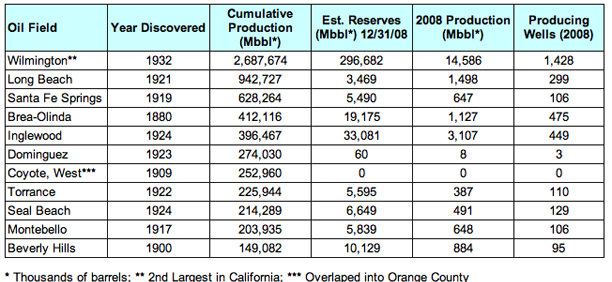
The first successful commercial well was the one known as Pico No 4, which was originally drilled in the 1870’s and not shut-in until 1990, giving a start to the first oil town, Mentryville, in the state. It led to the development of the Los Angeles Basin, of which:
As attorney for the petroleum industry, Bruce Webster, once commenting to Los Angeles magazine about an oilfield, said, “They ruined a perfectly good oilfield by building a city on top of it.”
The first well was apparently drilled using the sharpened end of a eucalyptus tree, in 1892; by 1894 there were 80 wells in the area, and by 1897 some 500. Unfortunately Emma Summers, who owned half the production in 1900, was not a relative. She became known as “California’s petroleum Queen,” owning fourteen wells.
Her wells produced 50,000 barrels each month. At first she sold her oil through local brokers, but eventually took on that challenge in addition to managing her supplies, 40 horses, 10 wagons and a blacksmith shop. Summers sold her oil to downtown hotels, factories, Pacific Light & Power Co. and railroads.

As the production of oil grew from 4 million barrels in 1900 to 77 million in 1910, so the city over the fields also grew, tripling in size over that decade. This has led to some conflict, and there is an interesting video showing how some of this has ultimately been resolved, with oil rigs camouflaged within the community.
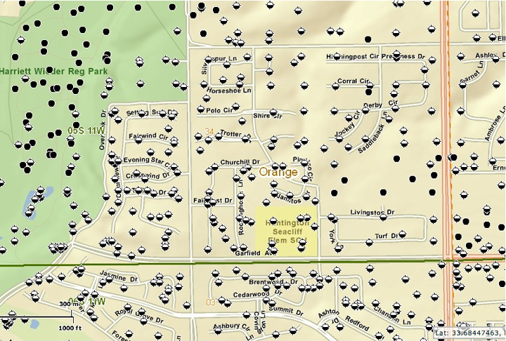
As the original field began to deplete, exploration brought in other fields starting with Huntington Beach, in 1920. The first well there was not that encouraging, but the second came in at 2,000 bd, and the community rapidly grew. It is here that directional drilling was first used, to reach out to the tidal region off-shore. The town was initially largely stripped of the original buildings as the oilfield developed, and I am indebted to Debbie Cook for this map, which shows active (black) and capped wells for the city in more recent times, and gives some sense of well density.
As with many fields, the original high production from a relatively small number of wells was not matched in later years as the number of wells grew.

Huntington Beach was followed by Santa Fe Springs, which went through a similar transformation. An initial well proved the field in 1919, and this was succeeded by the Bell #1 that came in at 2,500 bd. By 1929 it was the state’s largest oil producer, covering 1400 acres of land and it was producing some 275,000 bd.
It was followed by the Signal Hill discovery, beginning with the Alamitos #1 well, which came in on June 23, 1921, but caved in and had to be cleaned before establishing a production of 1,000 bd, with an ultimate recovery of some 700,000 bbl.
Oil promoters were selling shares of wells that had not yet been drilled. Signal Hill was to prove so prolific that, almost unbelievably, many of those buyers actually made money on their investments. The next-of-kin of persons buried in the Sunnyside Cemetery on Willow Street would eventually receive royalty checks for oil drawn out from beneath family grave plots.
By 1923 it was producing some 259,000 bd from some 300 wells, in comparison with Huntington Beach, which was then at 113,000 bd and Santa Fe Springs at 32,000 bd. In combination they were producing, at the time, a quarter of the world’s petroleum. And, in a foreboding of the future problems of over production, this was the first year in a decade in which supply exceeded demand.
The Long Beach field, of which Signal Hill was a part, went on to produce over 900 million bbl of oil by 1980.
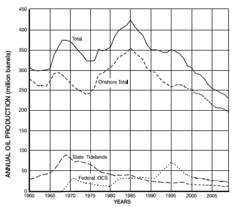
California’s overall oil production peaked in 1985 and is currently declining at around 3.3% a year, with 2009 production at around 630,000 bd, with the largest production at that time coming from the Midway-Sunset field at some 93,600 bd average production. In 2009 there were 2,570 wells completed to production in the state.
There are, however, some other aspects to the fields in California that I don’t have space to cover in this post, and so I shall return to the topic next week.
Contact
- Content: editors at theoildrum dot com
- Tech support: support at theoildrum dot com
License

This work is licensed under a Creative Commons Attribution-Share Alike 3.0 United States License.
As a native of southern California, I can attest that these wells tend to reek of a sulphurous smell (not all crude oil is alike, in terms of the refining cost).
Here is some info on the grades of California crude:
http://www.energy.ca.gov/2006publications/CEC-600-2006-006/CEC-600-2006-...
This is an eye opener. According to this report, only 2 decades ago California local drilling was supplying as much crude as it was importing, and over the last two decades the local drilling has dropped by 50%. Why? The industry continues talking about such huge oil deposits under California. Shouldn't local drilling have increased by double instead of dropped by double. What are the excuses? Are the oil deposits too difficult to drill for? Are there environmental issues? Regardless of whatever reasons, it makes more sense to pay our own countrymen to harvest our own crude and keep the money within our economy, instead of sending the money to regimes that will use our money to try to destroy our country. It just doesn't make sense.
Your talking about California here...They are barely able to build solar power in the desert because of concerns for the local plants:
Calico Solar
And wind power kills the birds:
Wind power kills birds
The cruel fact is that California has produced almost all of its oil reserves. Despite the talk about huge oil reserves, there is nowhere else to look for new oil in California. All that is left is to produce the last dribs and drabs of the remaining oil that can be extracted, at high cost.
California will have to rely on importing more and more oil from other parts of the world. Unfortunately, there are a lot of other countries who will be competing for that oil, and supplies are diminishing, so California will not be able to import as much oil as it wants.
California will have to consider moving to a less car-centric lifestyle. This transition will probably not be optional, so people might want to think very hard about how to do it. Actually, Southern California once had the largest inter-urban electric rail system in the world, and abandoning it might have been a bad idea.
I stayed at a vacation home in Huntington Beach once. It was pretty surreal to be walking through a neighborhood of fancy beach houses interspersed with the occasional stripper well.
Here's a nice photo gallery of LA oil: Urban Oil Wells in Los Angeles | Los Angeles | NileGuide The video linked to in the article plays a bit choppy. The book Early California Oil: A Photographic History, has photos of pumpjacks in backyards, or in alleys between houses, etc.
Beverly Hills High School - site of controversial litigation
http://www.google.com/imgres?imgurl=http://farm1.static.flickr.com/71/21...
Is there a typo in the Long Beach figures? R/P looks way out of line compared to the others.
Have there been any problems with subsidence after abandonment? I used to live in an area where there were abandoned mine workings, and every so often a hundred year old plug would give way taking whatever was on top of it down the shaft, or a house would be condemned due the shifting ground making the structure unsafe.
The Wilmington field in Long Beach harbor was a well-known example of oil field subsidence, reaching a rate of 2 ft/year at peak of production, a big hassle as it affected existing port infrastructure a great deal.
I don't think it's a typo...just incorrect.
I'd estimate that the major producer from Long Beach Field (Signal Hill Petroleum) did just under 1 million bbl in 2008. It's hard for me to believe that the remaining small producers picked up a half million bbl.
I don't know of any subsidence problems in the Long Beach Field, but accurate elevation data is hard to come by for the time before the oil field development. Certainly the available topo maps from prior to the discovery do not indicate significant subsidence.
Waterflooding on the Long Beach field was began in 1964 to both sustain production and prevent the subsidence that had occurred in the Wilmington Field to its south. Long Beach Oil Field - Wikipedia, the free encyclopedia
Injection of water was not significant in Long Beach Field till the late 1970's when the three majors (Texaco, Shell, and Arco) did a pilot project to determine the effectiveness of water-flooding. Prior to that time it would be somewhat charitable to call the injection a true waterflood, a better characterization would be water disposal. Especially since old wells were converted to injection rather than new wells being drilled for that purpose.
I have no doubt that somewhere in the waterflood proposals submitted to the DOGGR that the term subsidence was included. But the fluids injected could hardly have been of significant volume to affect any change in subsidence at that late date.
Unlike Wilmington Field, it has not been necessary to adjust well log data to accommodate changes in horizon tops due to subsidence.
Harold Hamm is tied for 44th richest American.
http://www.forbes.com/wealth/forbes-400/list
Does J. Paul Getty fit into the list of richest oil men? He seems to have been the richest American in the late '50s and early '60s.
I associate him with Los Angeles, mainly because of the Getty museum.
In the sixties he owned a large swath of Wilshire Blvd. one of the more expensive areas in Los Angeles. He also wrote a regular piece for Playboy magazine at the time and was noted for driving an old Mercury Comet to work every day. Plenty rich and eccentric.
If Wilmington is the second largest field, per your table, what is the largest one ?
Much is made by the "Drill, Baby, Drill" crowd about the ban on drilling by Santa Monica (at one time the oil companies with offshore leases bought a grocery store with the intention of shutting it down and directionally drilling offshore from there).
Any idea of potential undrilled reserves of Santa Monica, and all of California ?
Given the narrow offshore shelf I would guess not much, but any #s ?
Best Hopes for SOME new oil fields in 2030,
Alan
Midway-Sunset. Check it out on a satellite photo. Looks like a swarm of ants, no?
This 1993 doc (pdf) is a nice roundup: Largest U.S. Oil and Gas Fields. Huh, Kuparuk River was #1 for ultimate recovery, not Prudhoe. Hardly anyone's heard of the former - the #2 North Slope field, they discovered it within a year of the Prudhoe Bay #1 well. Creaming curve, anyone?
Top 10 2004 producers in California, with date of discovery:
Got mature region? Taken from a pdf on this page: Oil Industry Statistics from Gibson Consulting - largest
Here's an EIA table that lists CA offshore reserves:
http://www.eia.gov/dnav/pet/pet_crd_pres_dcu_RCASF_a.htm
There are also Federal CA offshore but I don't know the relative geography of the two:
http://www.eia.gov/dnav/pet/pet_crd_pres_dcu_R5F_a.htm
The reserve numbers look small, but the symbolism remains priceless. There you have it, the most famously car-dependent spot on the entire planet, populated by some of the most famously conceited folks on the planet, so conceited that bearing even the most trivial risk with respect to fueling all those cars, is simply beneath them, a matter for lesser beings someplace else. (Reminds me, though, of Florida, which, absent jet-based mass tourism, would be only a bug-infested backwater no one would need to care about.)
Thanks for bringing that up. Please recall 10-12 years ago when the State of California sued Enron and other trunk line natural gas gatherers delivering gas to California in a blatant attempt to set market value for Texas natural gas based on what it believed was "fair" to its utility customers. Californian's require, demand, cheap, plentiful energy but insist it come from the wastelands of W. Texas and that "muddy bog" we call the Gulf of Mexico, absolutely not off its pristine coastline, no sirree. It seems that I have read there are significant Monterrey reserves remainning in and north of the Santa Barbara Channel in very shallow water, at shallow depths, suited for high sulfur refineries already in place in California, but lets face it, there will never be another offshore well drilled in California.
I use to like to remind all my friends from Caifornia when the oil bashing begins that since the Santa Barbara blowout of 1969, 42 years ago, 93% (by incident) of the oil spilled into the world's oceans that have fouled coastlines came from tankers transporting oil and not from out of control wells located on offshore drilling or production platforms. Unfortunately I had to bag that argument last year about the time BP was having brain farts in the GOM. About all I can say now is the second biggest mess in American history was the Exxon Valdez mess and that oil was outbound on a tanker, for of all places, Long Beach, and maybe in the absence of a moratorium against offshore drilling Califonia might have had enough of its own oil to not need Alaskan oil and even THAT could have been avoided. Some folks displace a riser connection without a CBL across a liner hanger, others get drunk driving a boat and go right when they should have gone left; to error is human, right? The point being all of us fossil fuel abusers get a little egg on our face from time to time, even our dude friends in California.
Man those guys can squeeze blood out of a turnip though; if you ever get close to Taft, take a drive thru Midway-Sunset, wow. Its a plumbing miracle.
California is still the #3 oil producing state, and some months it's ahead of Alaska. Take your stereotypes someplace else, and pay attention to the data. Areas with high population density don't produce the bulk of their raw inputs. Duh.
I recall reading somewhere that parts of the Ventura field northwest of LA had more oil per acre than any site in the world. The oil was found at multiple levels. The late L. F. Buz Ivanhoe, who retired in Southern California, made an educated guess that there was not much oil left off the Santa Barbara/Ventura coasts and that it was of low quality and of relatively little interest to the oil companies. On many occasions I got tar on my feet while walking or running on Southern California beaches, both before and after the Santa Barbara spill. The Santa Barbara organization GOO (Get Oil Out) is still in existence.
http://www.getoilout.org/
There is naturally occurring tar in that area's beaches, from what I understand.
True, the tar was used by the Chumash Indians.
http://missiontour.org/related/chumash.htm
My sister has lived in Santa Barbara since about 1966. She is pretty strongly against further drilling but thinks that there is LESS oil on the beaches now than there was back then. I suspect that the continued production has relieved pressure enough to reduce the seepage.
To clarify: Although there is a drilling moratorium production continues and a peak occurred in 1992, 23 years after the famous spill.
http://www.countyofsb.org/energy/information/history.asp
jj - All relative I suppose. Saw a report from the state of CA a good while that estimated 75,000 or 175,000 bo per year from a natural seep on just one lease block in the Santa Barbara Channel. And there may be no drilling but in reality most man-made spills come during production ops and not from drilling. There's probably still some oil getting into the water from ops but I would imagine it's relatively small compared to natural seeps. Given how closely the state monitors the situation and the huge fines they can hit operators with I suspect the companies are doing all they can to prevent accidents out of self preservation if nothing else.
I lived and surfed in Santa Barbara in the 60s and 70s.
Places like Coal Oil Point were famous for seepage.
It took a lot of work getting tar off feet, out of hair, stained wet suits, etc.
An interesting bit of research on this point.
http://ehp03.niehs.nih.gov/article/info%3Adoi%2F10.1289%2Fehp.1103478
Abstract
Background: The negative health effects of Polycyclic Aromatic Hydrocarbons (PAHs) are well established for modern human populations, but have so far not been studied in prehistoric contexts. PAHs are the main component of fossil bitumen, a naturally occurring material used by past societies such as California’s Chumash Indians as an adhesive, as a waterproofing agent, and for medicinal purposes. The rich archaeological and ethnohistoric record of the Coastal Chumash suggests that they were exposed to multiple uptake pathways of bituminous PAHs, including direct contact, fume inhalation, and oral uptake from contaminated water and seafood.
Objectives: To investigate the possibility that PAHs from natural bitumen compromised the health of the prehistoric Chumash Indians in California.
Conclusions: The ancient Chumash Indians’ exposure to toxic PAHs appears to have gradually increased across a period of 7,000 years, due to an increased use of bitumen in the Chumash technology, together with a dietary shift towards PAH-contaminated marine food. Skeletal analysis indicates a concurrent population health decline that may be related to PAH uptake. However, establishing such a connection is virtually impossible without knowing the actual exposure levels experienced by these populations. Future methodological research may provide techniques for determining PAH levels in ancient skeletal material, which would open new avenues for research on prehistoric population health and long-term effects of human PAH exposure.
A news article on the research:
http://www.newscientist.com/article/mg21028154.300-asphalt-may-have-pois...
yep - so let's burn it all and turn it into beneficial CO2. Fossil fuels are a miracle - cleans the environment, provides conditions for better plant growth and gives us cheap energy!
Too bad we are running out...
Was curious about what percentage of California's gasoline they could produce from this oil.
From the chart above, 230 Million bbls per year, / 365 = 630,000 bbls/day.
about half is the usual conversion to gasoline -> 315,000 bbls/day.
x 42 gals/bbl = 13.2 million gallons/day.
So how much gasoline does California use per day?
http://www.eia.gov/dnav/pet/pet_cons_refmg_d_SCA_VTR_mgalpd_a.htm
around 8 million gals/day, though dig the drop in 2009 to 6.699!
So guess they export gasoline, unless their heavy oil doesn't convert well...
So why is Cali gas so expensive? blend rules? everything else is? because they can? ???
http://www.arb.ca.gov/fuels/gasoline/faq.htm
It costs money to make it
Per day - this is what I came up with
16 billion gallons were sold in CA in 2007
Source: http://energyalmanac.ca.gov/transportation/summary.html
That equals 45 million gallons per day. That's a bit over a gallon per person per day.
Hmmm - discrepancy city...
Ah - the data I gave was from "refiner sales" but the little pulldown menu
labeled "Sales Type" says "retail sales".
I thought that would be all retail sales, but apparently it is just retail sales directly by refining companies.
Another choice in that pulldown is "Sales for Resale - Total"
http://www.eia.gov/dnav/pet/pet_cons_refmg_d_SCA_VWR_mgalpd_a.htm
No data given for 2007, but 2006 is 33 Million gals/day.
Added to the 8.4 Million gals/day (2006)
http://www.eia.gov/dnav/pet/pet_cons_refmg_d_SCA_VTR_mgalpd_a.htm
comes closer to 45 million gals/day.
(wondering if ethanol is the difference between 41.4 and 45?)
Tricky EIA tables....
So back to my original conclusion - it's VERY WRONG!
California does NOT export gasoline based on native oil production.
They need to import like 2x more crude equivalent/product than the crude they produce to meet their needs (ie if they make 13 million gpd, they still need 2x+ that in addition).
Errr....
Thanks for bringing the numbers you found to the party.
California exports refined products to Nevada, AZ, and OR. California retail gasoline is more expensive than most places for 3 basic reasons, in order of importance: 1)Sales tax (they charge sales tax on fuel in addition to the fuel tax, and the sales tax rate is high), 2)Real estate (gas stations have higher overhead), 3)Refining cost (due to refinery input and energy costs, as well as fuel blend regs).
Just to remind all AAPG members that the 2012 Annual Convention is from 22nd to 25th April 2012 at Long Beach CA!
Last time in 2007 they ran excellent 1-day field trips to Kern River (I had a project just north of Mt Pozo at the time), and the oil fields of the LA Basin, stopping at Signal Hill, Inglewood (run by Plains) and a couple of small fields in Hollywood. Both trips are thoroughly recommended.
Center for Land Use Interpretation
www.clui.org
If you find yourself in Los Angeles, they have a small exhibit at their office and are very interesting to talk with.
Right next door is The Museum of Jurassic Technology.
www.mjt.org
Huntington Beach oil field pictures:
http://3.bp.blogspot.com/__APCzEFEiDk/SYL_0WQ9qrI/AAAAAAAAAgI/7wtdbjjT3s...
http://4.bp.blogspot.com/-vnSLDYtv5Xg/TdIf5I1byoI/AAAAAAAAAaM/xahLnkmZ0-...
I am curious, why do those wells need to be packed so tightly together?
NAOM
I bow to more knowledgeable folks but intially when early oil fields were being developed the rule of capture prevailed; in other words if you had one acre of surface leased you could drill a well on that one acre and capture whatever oil was directly under you. Often in places like Signal Hill, or Spindletop, the wooden derricks of rigs literally touched each other. Eventually proration and conservation efforts were undertaken by regulatory agencies to preserve the natural energy of the reservoir and increase recovery oil rates. Wells had to be drilled on established, minimum distances between wells and with minimum acreage allocations per well. In wonderful old photographs like the ones of Huntington Beach please also remember those wells were drilled directionally (deviated is probably a better term) out into the ocean and surface space along the highway was a premimum.
In the early era of oil development, before proration and spacing requirements, wells drilled on one acre surface tracts occassionally came in (blew out) unexpectedely when mud weights were not balanced properly and/or when valves could not be stabbed over out of control flows soon enough. These were, as you know, often called "gushers." Sometimes those wells would accidently catch fire and then other wells downwind and in the immediate area in various stages of progress would also catch fire. It was not often very neighborly to allow your well to blow over the crown while you danced with joy covered in oil.
The only means of well control in those early days was using water, or steam from the rig boilers, to cool the fire until the well bridged, or collapsed downhole and the fire went out on its own. Often wells would burn for months. It was not until 1913, in the Midway-Sunset field by the way, that extenguishing fires using explosives was developed and oil well firefighting efforts began in earnest. The man who developed that proceedure was Karl Kinley; his then 15 year old son Myron Kinley helped him and later went on to become what the industry now recognizes as the "father" of the oil well firefighting profession. Myron Kinley developed many of the techniques and equipment back then, nearly 100 years ago, that is still used today. Myron worked essentially by himself, around the world, from 1924 to 1946 when he hired a youn man named Red Adair to help him and eventually also Boots Hansen and Coots Matthews. Everyone learned from Myron Kinley, directly or indirectly. I think it is very noteworthy to know that the blowout control profession, and the man who started all of it, was a Californian. Thank you for allowing me that rant; it is something very important to me.