Hurricane Ike, Energy Infrastructure, Refineries and Damage Models Landfall Thread (Updated 9/13 18:00 EDT)
Posted by Prof. Goose on September 14, 2008 - 10:30am
Updated 9/14 900 EDT. Hurricane Ike made landfall in Galveston in an area with extensive oil infrastructure, namely over 5 million bpd of US petroleum refining capacity. (5 MMBBL is about 30% of US capacity (about 15 MMBBL), and a bit less than 6% of global capacity (~85 MMBBL)).
Our thoughts and prayers go out to those affected by this storm. We would ask that you please keep this thread on point with Hurricane Ike and energy-related articles, stories, maps, data, and links in the comments.
(Graphics and damage forecasts moved below the fold for bandwidth and spacing...it's all still there...this continues to be the thread to accumulate resources as of 9/14.)
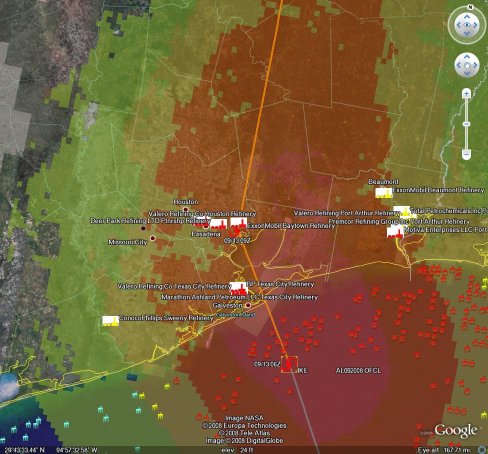
Path observations and damage estimates for Hurricane Ike--Methaz NHC official track Sep 13 (7:00 EDT)-click twice to enlarge
For all graphics: Rigs/Platforms: Blue: evacuated only; Yellow will require inspection before restart; Red: damage requiring repair; Refineries: Black: operational impact (partial shutdown) Green: Operational impact (full shutdown) Red: Damage likely; Ports: standard hurricane flags for wind
Here is the latest update from Chuck Watson at KAC/UCF updating at 9/13 700 EDT:
Intensity: folks have questioned my landfall estimate, but the data supports it. Examples: Buoy 42035 broke loose from it's mooring, but apparently it passed through the eye and reported valid data. See attached plot (note: it's below the fold) - peak winds 55 kts/gusts to 75 kts. RLOT2 failed at 4z, last report was 50kts/65kts, water level 11ft above normal. The station near Texas City, in the left eye wall, peaked at 60 knots. Surge peaked about 12 feet. All of the data indicates landfall wind speeds were no more than 85 knots 2min average winds. The NHC estimated 110mph/95knts "sustained" (whatever that is; nothing measures a "sustained" wind), which would be about 92 knots 2 min average, but as noted earlier they always err on the high side.
Inland areas do NOT seem to be experiencing significant two minute average winds above hurricane force. Don't be mislead by the media reports of "hurricane force wind gusts". Gusts don't count. Scientific definitions matter. I get "hurricane force wind gusts" in thunderstorms here in Savannah all the time.
Impacts: I think the most severe impacts will be confined to the barrier islands. Galveston probably got whacked hard. But I don't think any of the refineries will suffer major damage, unless something broke that shouldn't have. It looks like Baytown never caught the peak surge. Texas City might have seen some flooding, but I doubt it was severe.
Don't get me wrong, there will be a lot of damage from this event - insured losses in the $15 to $20 Billion range, storm total impacts in excess of $60 Billion (if you include evacuation costs, etc.). But with what I see right now, my guess would be that the petrochemical industry recovers fairly quickly, with refinery down times in the days to 2 week time frame, not months. I think the biggest problem is going to be staffing and debris cleanup. The infrastructure was probably OK, but power and crews with damaged homes and cleanup issues will be a big problem.
Harder numbers later today, but my estimates from yesterday are probably pretty close on outage probabilities.

Buoy 42035 reports through Hurricane Ike-click twice to enlarge
MMS reported yesterday that:
97.5% of the oil production and 94.4% of the natural gas production in the Gulf has been shut-in; Personnel have been evacuated from a total of 596 production platforms, equivalent to 83.1% of the 717 manned platforms in the Gulf of Mexico; Personnel from 101 rigs have also been evacuated--this is equivalent to 83.5% of the 121 rigs currently operating in the Gulf; that staff has been evacuated from 452 production platforms (63.0%) and 81 rigs (66.9%) – (95.9% of the oil production and 73.1% of the natural gas production has been shut-in as a precautionary measure for Hurricane Ike.)
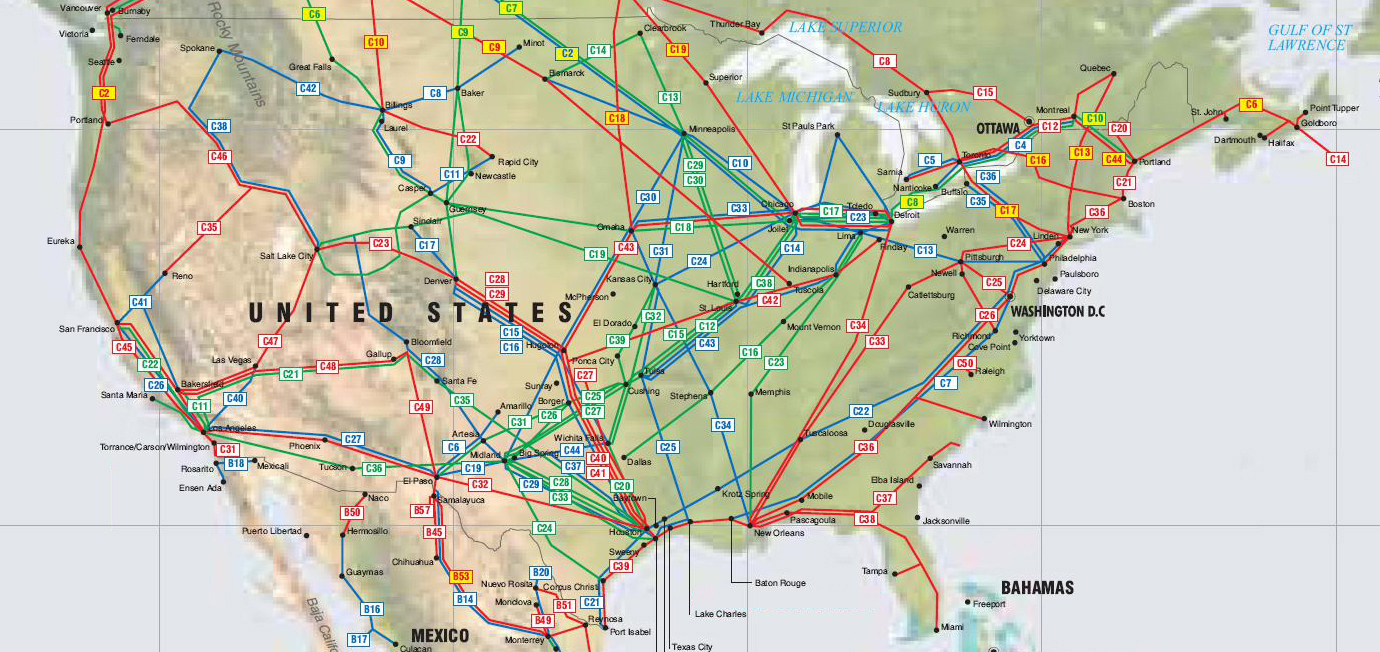
Here is a map of the critical pipeline structure expanding outward nationwide from the Houston/Port Arthur area:
Here are depictions of various Texas cities storm surge maps under different Hurricane scenarios from Weather Underground.
Chuck Watson has put together a dynamically updating page that will reflect the latest damage models/forecasts at this link: KAC/UCF models. We will be updating this thread with damage estimate and breaking news as this story unfolds.
A note on Chuck's modeling process: we take the official NHC track, the raw computer model tracks like GFDL, HWRF, LBAR, etc, and even run our own in-house fast cycle track/intensity models. These track and intensity estimates are feed to our main hurricane model (TAOS), which computes the wind, waves, storm surge, currents, etc. at each point in our database of over 50,000 elements in the GoM like rigs, platforms, pipelines, pumping stations, refineries, etc. We then have engineering models for each type of infrastructure that calculates the damage and estimated down time for that element, as well as downstream impacts (eg if a pipeline is down, the upstream elements can't pump and the downstream elements don't get product).
PRODUCTION/INFRASTRUCTURE MAPS AND REFINERY INFORMATION
Here's a link to a really good map of oil refining/SPR storage facilities in respect to the path of Katrina (NB: OLD TRACK MAP!) and here is a listing of production and refining capability for the state of LA.
Also, here's the EIA's Alabama, Louisiana, Mississippi, and Texas Resources pages. They will also likely come in handy. Also, here's a link to the national page.
Here's a map from CNN with large and small refineries laid out. (though it is an old storm track)
Very detailed piece by RIGZONE on rigs and other infrastructure in the area. (thanks mw)
Here's a flash graphic of the oil refineries and rig maps from Hurricane Rita, it emphasizes Beaumont and Galveston's importance. Click on oil production in the tab. Note the many rigs on the east side of the storm that will get the brunt of the damage from the NE quad of the storm...hence the high long-term GOMEX oil production damage estimates below.
Here's a link to Rigzone's coverage of Ike.
You want a detailed map? Well here's the probably the best MMS map I could find. Very detailed and lots of interesting stuff. (VERY big .pdf warning)
Also, Scott Wilmoth at Simmons & Co sent us this map on deepwater infrastructure. For a complete list of deepwater development systems (includes operator, depth, location): http://www.gomr.mms.gov/homepg/offshore/deepwatr/dpstruct.html
(Please deposit new relevant links, graphs, and comments in this new thread...please leave long personal anecdotes and themes unrelated to the storm for the other upcoming 'bigger picture' posts, as some of the larger images are difficult to upload for those on dial-up)
We will be posting continued updates of track and damage forecasts here, because one never knows when one of these events may have more than just local impacts. We're not hurricane experts at theoildrum.com. Thankfully we have an expert meteorologist who sends us track and damage forecasts relevant to oil and gas infrastructure. What we try to do on this site, (and have been doing for over 3 years), is articulate the fragility and urgency of our nation's, and our world's, energy situation. As Hurricane Ike moves nearer, and professional analysts gauge the impact it may have on our energy infrastructure, feel free to browse our archives of empirically based analyses and perspectives on the many aspects of our energy situation that form the backdrop not only for this hurricane, but for any exogenous event that disrupts the increasingly uneasy balance between energy supply and demand.
Hurricane Ike, Energy Infrastructure, Refineries and Damage Models Landfall Thread (Updated 9/13 18:00 EDT)
PDF version
159 comments
Hurricane Ike, Energy Infrastructure, Refineries and Damage Models Landfall Thread (Updated 9/13 18:00 EDT)
PDF version
159 comments
Contact
- Content: editors at theoildrum dot com
- Tech support: support at theoildrum dot com
License

This work is licensed under a Creative Commons Attribution-Share Alike 3.0 United States License.
Posted in the 3rd Ike thread -
For anybody with more geographical awareness of Texas than I, the following link of river flows could be interesting -
http://waterdata.usgs.gov/tx/nwis/current/?type=flow
What is really interesting to me is that the Neches River currently has a flow of -32000 cubic feet a second - that is, the water is now flowing the wrong direction in that amount. The previous record flow for this measuring station was 8580 - the average is 5290.
http://waterdata.usgs.gov/nwis/uv?08041780
Just more of that overhyping of data - the measured flow in the wrong direction is basically 4 times greater than the previous measured maximum. And basically, all of that water will be coming back - this storm will take a while before its effects are over, much less known.
Leanan then posted 'Some Texas official on CNN last night said that was an advantage. It'll wash in, then wash back out again. No big deal. We're not a bowl, like New Orleans.'
Sometimes, I truly wonder about people - that official is now staring at something like the 3 times the greatest amount of water measured on the Neches coming back, and it is not a big deal, because Texas isn't a bowl?
Where do you find such profound talent to be in a position of responsibility for an emergency?
EDIT - I know basically nothing of the area - Salt Water Barrier, Beaumont Texas, but to the extent that there are bridges, dams, or anything along the river banks, they are likely to be subjected to forces that their designers never imagined. Odd as this might sound, at least in a case like this, being a bowl likely helped New Orleans in this regard.
I really can't believe that people have so little understanding of what that much water will do - but then, Agnes was a rarity, and one of those once in a lifetime events. Until Floyd hit - which meant that most of the plans for the unfunded flood control work could be pulled out of the cabinets, to be ignored for the future again.
We really don't learn.
We, as a species, have always learned by building personal pattern recognition databases and by following others (mirror neurons).
In the current generation, there is no pattern bank for using the precautionary principle, or planning for a rainy day, just for consumption (on average). It is very difficult (nigh impossible) to tell someone of this mindset that things could be different, unless they are told by someone in authority or a majority of people they trust. Conventional media is primarily entertainment, and the real 'news' has shifted online..
Regarding Chucks relief (and preliminary good call on dodging an energy refining disaster), we were close to an example of where money wouldn't have the ability to bail us out (Bear Stearns, Fannie Mae, General Motors, Lehman, etc.) No amount of money could have made up for months of 3-5 million bpd of refining capacity offline. And at a 1 for 1 price elasticity for oil product, that would have been a minimum 15% drop in GDP, though I think there is a probably a MOL of gasoline availability needed to keep country 'running'. What could have been....
Interesting (and dangerous) times.
The bible warns about building on shifting sands yet people build houses on sandbars in hurricane zones.
ARE people smarter than yeast?
I'm struck by how much of Chrisian imagery is agricultural, pastoral. Interestingly, I've been thinking about old testament Joseph who stored 7 years of grain for Egypt and saved the country from drought. Looking at my own grain bins and wondering what 7 years of grain storage would look like.
The book of Isaiah is about a collapse and the "saving remnant" that remains. In fact, that is Isaiah's whole job-- to inspire the "saving remnant." Maybe like Oil Drum- a voice in the wilderness. Anyone read The Road by Cormac McArthy? I think that book is a metaphor that takes Isaiah into account.
Nate-- appreciate your researched thoughts about the current generation learning consumption rather than "saving for a rainy day" or precautionary principles. I'm going to quote you in a speech I'm giving to the Farmers Union next week. It is obvious that you cannot "tell" people that times could change dramatically. I suspect that some of these old farmers in the Union will know exactly what you mean-- some having lived through the depression.
Latest Neches data - -33,400 cubic feet a second, or 14,989,920 gallons a minute - flowing upriver.
Somewhere, this mass of water will collide with the normal downriver flow - and the area where it does will suffer from severe flooding, likely miles from the coast.
Looking at the basic map, it looks like I-10 and a railroad could be in at least potential danger of being cut, depending on how they cross the river, and how well the bridges/overpasses were built, and to what extent the road/rails are higher than the floodwaters.
Lucky it isn't a bowl, though. Wonder if that official's name is Brown?
A report from someone who stayed on Galveston Island:
http://news.yahoo.com/s/ap/20080913/ap_on_re_us/ike
Our civilization's future in a nutshell.
Lucky that he had this chance, he could not have this chance! Maybe another people don't get a second chance.
One of the anchors on The Weather Channel asked a person that is currently in Galveston why they decided to stay.
They replied that they wanted to surf the waves the next day!
You can't make this stuff up!!!
peakoil.com: Are humans smarter than yeast (nod to Bob Shaw).
Would make a good poll here.
I assume the surfers were young men. Men under about 25 may be smarter than yeast, but they definitely don't have more common sense than yeast
A CenterrPoint spokesman said that they are looking at essentially a 100% blackout for the entire Houston metro area, with the exception of the areas like Medical Center and City Hall that have underground connections.
A decent link from wunderground for local information in that region -
http://www.khou.com/topstories/stories/khou080912_mh_Ike_damage_reports_...
The Houston Chronicle. web site is up this morning. Might be another good site for local information.
E. Swanson
Heart of U.S. Oil and Gas Industries Shut Down as Storm Approached
After all the natural gas shutdowns in the GOM; stocks rose last week and are well above the 5-year average. Worldwide LNG capacity is scheduled to rise. New drilling rigs are being built.
Above in the main report for this page there is a map of "the critical pipeline structure expanding outward nationwide from the Houston/Port Arthur area:"
But it has no map key to tell you what the different lines represent. Does anybody know what the different colored pipelines on the map represent? Which color is NG, which is petroleum or gasoline or whatever?
Also there are some crossing the Canada border. Are those all now carrying fuels to the US, or do some carry fuels to Canada?
We sheltered in place in west Pearland near the Brazoria/Fort Bend/Harris County line. We lost power last night at 8, still have water and gas. Damage here appears to be minimal. I have heard grom some stubborn relatives in Angleton, 30 miles south in Brazoria County. They report a bit more damage than here, but mostly just fences down and shingles blown away. Still some hard gusts, but the worst is past us. I'll be interested to see what Galveston looks like.
Surreal. Here in Seguin we had no rain, hardly any wind. Same with our place in Gonzales County.
We have people. Lots of people that will need gas, gas that in some places has jumped to the $4.30 range and in others remains cheap. I am told the cost differences reflect when the station last purchased fuel, which would indicate that it's likely to be going up across the board soon. Oddly enough the highest priced fuel in San Antonio was at a station that normally has the cheapest prices and consequently ran out and had to be resupplied sooner.
The eye of the storm was large and it appears that the sea to land directed wind and surge will be found to have occurred East of the Galveston Bay in spite of the fact that the eye passed directly overhead.
I saw someone on the East Coast complaining about the price of gas going up before the storm hit. Guess he isn't aware that the refineries closed ahead of the storm and someone has to put fuel into that pipe his station gets it out of on the other end.
In retrospect, Chuck Watson's analysis appears to have been correct. Newscasters continued (and continue) to insist that we had 110 mph sustained winds and perhaps we did at some places, but every minute by minute wind speed figure I saw quoted was significantly lower in number and in line with his estimates.
Consequently, I suspect most damage will be water related.
I also expect the number of lives lost will be minimal compared to the massive losses of property. It could be that the damage to infrastructure needed to maintain oil facilities will prove more problematic than actual damage to the facilities themselves.
In an economy already staggering, the financial weight of this storm will be substantial.
Every major hurricane has this pattern.-Andrew comes to mind.
The first people to report in are those who can, or
like WT's report, those who straggle in to FEMA HQ.
Note that reporters are to the West of Ike.
Everything I've heard is that the surge from Galveston East to LA
was as bad as predicted.
One report of people on roofs in Orange.
Once the levees are topped they then keep the water in.
"As bad as Rita", FEMA in Hardin Co.
It took almost 24 hrs before NO realized they hadn't dodged the bullet that was Katrina.
I'm waiting.
Open question...
Certainly much pain and suffering and damage inflicted by Dolly, Gustav, and now Ike - and the season isn't over yet.
We should be grateful that the GOM this year - thus far - has not been able to build and sustain Cat 3+ storms notwithstanding the size of Ike.
Is it the weather patterns, lack of SST, just plain dumb luck?
Thanks,
Pete
NHC was reporting the highest winds in the NE sector of the storm well away from the eye. These winds would have made landfall east of Galveston. This would also be the area with the highest storm surge. Basically between Galveston and Port Arthur. Not sure what is on that area of coastline. There are no automated stations or buoys in that area. Chuck Watson's plot from buoy 42035 is very interesting but that buoy went adrift and thus would have gone south before entering the eye. It would almost certainly not have experienced the NE part of the storm.
Had Ike made landfall 20 miles to the west, I think we would be looking at very different news stories from Galveston. I hope the people who stayed in Galveston realize just how close they came to a repeat of 1900.
I'm no expert, but I have heard that wind speeds measured at the ground are lower than wind speeds measured higher up.
The Hurricane Hunter planes measure wind speed up in the atmosphere. Those wind speeds are sure to be higher than at ground level (or sea level).
There is controversy as to the exact scaling factors on direct observations, but a Hurricane Hunter plane lifts off with a large bank of disposable parachuted sensors that give readings over the full elevation range, as well as its own sensors. They call them dropsondes. There is even a system of balloons being introduced in the eastern Atlantic to do the same duty without a plane - remotely deploy a dropsonde twice a day to test for low-altitude winds in hurricane-forming zones.
Although unfortunately now that limited tv news helicopters are back in the air and the tv crews have reached more badly hit areas (they still seem to have flight restrictions over areas apparently still completely under water which have rescues currently taking place) there are definitely increasing reports of casualties. The west end of Galveston island and the extreme east end were definitely not the place to be.
The Mayor of Galveston said that "47% of the tax base" was under water according to ABC13.
And just to the east.
http://www.storm2k.org/phpbb2/viewtopic.php?f=59&t=102847&start=13080
KHOU just now reporting that at least 2 oil platforms are adrift "100 miles off the Louisiana coast". No further details.
Local tv news atreaming at http://flhurricane.com/ikecoverage.html
Officials say 2 drilling rigs adrift off La. coast
The Rigzone Ike site has an nice update on this kind of news.
http://www.rigzone.com/news/hurricanes/ike.asp
Perhaps they're not adrift but rather being hijacked to the Southeast US.
Phase one of "drill here drill now".
"The Mayor of Galveston said that "47% of the tax base" was under water according to ABC13."
Words mean a lot. Its not the city he or she is concerned about, its the tax base! Thank you big government.
Her words may sound harsh, but when you watch her live you realize the concern she has for her town and it's people. Seems she was just trying to put into a few words the extent of the damage.
I gotta say, I got a laugh out of the "big government" line. This is Galveston Island, not exactly a huge metropolis.
Sounds like she was trying to get folks to realise how difficult it will be financing help for them - the kitty is empty.
So, you'll be a Palin voter then?
It sounds from what Chuck Watson said like the refineries behind Galveston did OK. As for Galveston Island itself, and other places, here are some additional reasons to wait before we discount Ike:
Dr. Jeff Masters' WunderBlog (http://www.wunderground.com/blog/JeffMasters/) said late last night that the storm was bigger and had more total energy than either Katrina or Rita.
It was so large and wide, with such an unusual eye that whatever harm Galveston Bay avoids will just hurt Port Arthur instead (where they were reporting 96 mph winds).
I read that the storm surge was only about 15 feet in the 1900 Galveston hurricane, the deadliest disaster in US history (because they had no surge walls then). I also read that the Galveston wall (which is only on the gulf side) is only 15 feet high.
Jeff Master's blog also shows that high tide at Galveston was at 2 AM.
Ike made landfall at Galveston just a few minutes after 2 AM.
I am finding lots of local news on the web from as far east as New Orleans of significant storm surge flooding.
Just saw a report about low elevation storm surge flooding as far south as Corpus Christi.
It sounds from what Chuck Watson said like the refineries behind Galveston did OK.
They won't know for sure until they try to start them back up. If they didn't get flooded, then things look a lot better, but they are still going to need basic utilities. Refineries can generally run on backup power when necessary, but they aren't going to start up on backup power.
I just spoke to my wife in the Dallas area (I am in Europe) and she said rationing is going on there. She went to fill up yesterday and said a number of stations were already out of gas. Based on the current inventory situation (lowest level in 8 years, and one of the lowest levels on record), there is a significant risk that large areas could run out of gasoline very quickly. (This has probably been discussed here already, but I haven't had a chance to keep up with happenings this week).
Robert -In a nutshell, Chuck's companies forecasts were for weaker than Cat 3 winds at landfall and said we could have a disaster (e.g. millions of barrels of refining offline for months) if the storm hit 10-20 miles west of Galveston and lesser (refining) damage the further east the eye went (due to the strongest surge on the north side).
So his analysis doesn't say that refineries are 'fine', just that we dodged a silver bullet that might have killed a werewolf...(i.e. 4-5mbpd offline for indeterminate time)..
So it's 'OK', compared to what it could have been.
<< I also read that the Galveston wall (which is only on the gulf side) is only 15 feet high. >>
The Galveston sea wall was built 17 feet tall back in 1904. But over the years, the shoreline has risen, and so now the sea wall is only about 10 feet tall (give or take a few feet).
Here's an interesting link to NHC modeling of the surge levels generated by Ike.
ftp://ftp.nhc.noaa.gov/surge/Latest/
The animated gif files are large, but worth a look. The one for the Galveston area is named i49_gl2.gif. Chuck Watson is right, in that the surge model is much less severe this morning compared to what the NHC modeled just before landfall.
Upper Houston Ship Channel peaked at 3.7 meters of storm surge and has varied between 3.5 & 2.8 m (currently 3.4 m). Houston official said that heavy rainfall will prevent a quick fall in Buffalo Bayou (connected to Ship Channel).
http://lighthouse.tamucc.edu/pd?stnlist=513&serlist=surge&when=09/06/200...
Alan
KTRH radio in Houston is reporting Buffalo Bayou waters are very high and rising, and close to overtopping the banks. The San Jacinto river, which is part of the ship channel, is also described as "flooding" and there are flash flood warnings in the area. Their forecaster predicted 2 to 5 more inches of rain across the area.
I wonder if the USS Texas remained moored at its park? I was wondering about the amount of surge going up the channel and its effect on the surround.
The USS Texas State Park weather station went off-line. I doubt that it was aboard the ship though.
Alan
I disagree: Gusts do count. This is why engineering interests are very keen on 3-sec averages. And also why the NWS implemented a new hurricane-force wind warning for frequent gusts of 75 mph and higher at coastal locations (used on Dec 2-3, 2007 along the Oregon and Washington coasts during a major windstorm). Frequent gusts of 75 mph and higher can cause widespread damage and pose a serious threat to life.
Houston Hobby Airport: NNE 75 mph gusting 92 at 0602 CDT. And many potential observations are missing around this time.
The above kind of wind would knock most people over, can lift off house and outbuilding roofs, roll trailers, and topple entire forest stands, among other forms of significant impacts.
The Houston Hobby wind report is more intense than the peak readings from Baton Rouge in Gustav. It would not be surprising if the electricity distribution infrastructure around the greater Houston area was severely impacted by Ike.
I do agree, by the way, with the idea that measures of hurricane intensity (Cat-1, Cat-2, etc.) be kept to the 1-minute and 2-minute average, as has been practiced in the scientific community for decades now.
-best,
Wolf
I was referring to the definition of storm intensity. Gusts do count for damage. For industrial type structures with towers, pipes, etc,. you get vibrational modes and fatigue failures that depend on many factors. If you look "under the hood", most engineering damage functions that claim to use "gusts" are simply multiplying 2min average winds by a fixed "gust factor", or some what better a factor based on land cover. So in reality they are using average winds. The actual relationship between average winds and gusts is very complex, as are the relationships between damage, average winds, and gusts, but using either average winds or gusts are fine for generic damage estimation, as long as you are consistent. And consistency is what is lacking.
The damage people expect from indexes like the Saffir/Simpson scale are based on average winds. The problem is that I'm afraid folks are being mislead by the hype surrounding these storms. In the popular (and, honestly, most engineers) mind the concept of "gusts" and "sustained winds", much less averaging or sensor height corrections, isn't that clear. It has real world consequences to inflate storm forecasts and reports. People think "Oh, I survived a category 3 hurricane" because somebody reported a gust, when in fact all they experienced were Cat 1 or even lower winds.
As my friend Dr. Peter Sparks (one of the worlds experts in wind engineering) once speculated, "Perhaps the NHC director is paid by the mile per hour".
I disagree that wind is "a serious threat to life", unless you live in a mobile home. If you look at history, water kills, but wind causes damage with relatively few fatalities. Evacuating so many people from wind risks killing more people due to evacuation than would have died had they sheltered in place. Plus they get in the way of the people on the coast who need to evacuate.
I do agree that sub hurricane winds can cause a lot of very expensive damage and power outages.
Hey, methaz, thanks for the reply.
Yes, I largely agree with what you're saying, especially with regard to the psychological effect of overstating such storms (e.g. "I survived Cat-3...").
However, I think we have a slightly different perspective on wind hazard: The loss of life in tornadoes is largely due to wind. This, I think, informs strongly about the potential for wind to jeopardize life.
That said, I think you're probably right about sheltering in place for most wind threats (and, yes, not in trailers). It'd take a serious hurricane to bring something like EF-3 or higher wind speeds far inland, the kind that you'd simply want to run away from.
-best,
Wolf
The simple expedient of adding a "safe room" requirement for all homes built in hurricane and tornado prone areas would seem to greatly decrease evac risk and potential loss of life. Flood areas need local "safe shelters" rather than long interstate routes. I have no problem with people leaving early and going far to make an evac into an unplanned vacation, but for the poor, work-tethered, or unwilling there should be a better solution.
Trailers will never be safe, and apartments may need some special thought, but there should be an "engineering solution" that wouldn't cost very much to keep typical families safe. Even an retro-fit safe room built to withstand winds and maybe some debris damages shouldn't be all that expensive.
The new trailers built to hurricane standards here in Florida have done very well. Of course, nothing is going to survive the imbedded tornados. I rode out probably a Cat 1 in my 40 yearold trailer, but I wouldn't want to do it again!
That Dec 2007 storm was quite intense here on the Oregon coast. The "usual" places flooded, and some interior areas were hit by imbedded microbursts of 120+mph that felled large swaths of trees. At one point, all the roads connecting the coast with the interior were blocked by downed trees. But power-wise, the utilities here build for such storms, and we suffered no power outage in my region. Also, the building codes mandate robust buildings. As the climate system becomes more unbalanced over time due to global warming, I expect we'll experience such storms more frequently, with their intensity increasing, too.
Advice from WT (Jeffrey Brown) and Robert Rapier, from Drumbeat thread, follows. This mainly applies to areas supplied by Gulf Coast refineries but Chevron is asking consumers nationwide to reduce their consumption in order to free up more gasoline for areas supplied by Gulf Coast refineries.
WT:
It's probably a good idea to start limiting your car trips to work and food runs (especially once the gasoline shortages hit in full force), and think about taking mass transit to work, if that is an option. You want to keep a reserve of gasoline in your car for emergency uses for as long as possible.
Robert:
I was looking at this (gasoline supplies) earlier today. This week's level is the lowest in 8 years, and is probably the lowest level ever in terms of days of supply on hand.
I spoke to my wife in the Dallas area earlier today (I am in the Netherlands) and she said gas rationing is already happening, and a number of stations are out of gas. I am telling all friends and family that there is a significant risk that major areas run out of gas in the next few days, so top off everything.
Thanks, Jeff. Passed it on.
Rat
You are being prudent, others are hoarding:-)
At least he is telling folks to limit gas use. I heard one official of some sort tell people this AM to "not panic" and to "keep on using gasoline like you normally would". Drive to the mall perhaps and do some shopping.
Ah, as ever, it's an irregular verb of the sort proposed by S. I. Hayakawa ;)
I prepare prudently
You stock up
He/she hoards criminally
See Language in Thought and Action (IIRC) for more...
Interesting dynamics. A pending shortage creates calls for conservations, but results in everybody immediately going to fill up. I was getting a donut yesterday at a convenience store in Tulsa, and asked about gas sales. They said the sale was comparable to the day before the ice storm last winter. He'd had two tanker refills during his day shift alone (usually they come at night). Of course Tulsa has plenty of refining, but the drawdown could exacerbate shortages elsewhere I'm sure.
I hear about complaints of price-gouging and rationing. With spot prices way up, I assume anything less than $5 will turn out to be supportable, though "gouging" is likely occurring sporadically. But in any case, if those at the end of the pipes and roads want fuel during shortages, they will have to pay extra to pry it out of the grasp of those along the way that want it too.
I wonder what will happen if EVERYBODY in the US makes a run on gas all at once, even if NOTHING was structurally broken prior to the rush?
Guilty as charged. My tank is full and I have been advising friends & family to do the same.
Do ya better: My strategic gasoline reserve (50 gallons) is full.
Me too -- another paradox, a crisis-worsening tragedy of the commons, where the obviously optimal individual response is exactly opposite of the optimal societal response.
Thats only in the very short term (i.e. under a week). In the longer term, the optimal individual response (measuring success by different standards, lowering their energy footprint because it makes their life better, living and doing more locally, etc), is ALSO the optimal societal response.
I was wondering how long I could make a tank of gasoline stretch, if I had to. There is a bus line about a quarter mile from our house, that would let me off about a half mile from my office. So, by taking the bus and by--horror of horrors for Dallas residents--walking, I could vastly reduce my gasoline consumption. There are several grocery stores, drugstores, cleaners, etc, along the bus line. So by shopping like Europeans do, e.g., food for a couple of days at at time (or by riding a bike to the store), I could reduce my consumption to the point that I only rarely would need a car.
But of course, because I don't use that much gasoline (short commute) and because it is still so relatively cheap and because having a car is so convenient, I drive. It does give one an idea of how much fuel many of us in areas with mass transit service could save, if we really wanted to (or had to).
My existing lifestyle (except electric streetcar instead of bus). Filled up in January, again in June (about 15 gallons) and again just before Gustav (6 gallons).
Bought my Strategic Diesel Reserve of 20 gallons (up from 5 gallons) 3 days ago. (Diesel keeps better than gasoline).
I will see if my theory that diesel will be preferentially produced in a shortage will come to pass.
Alan
Hi Alan,
Do you use a preservative? Thanks.
Don
No, I typically just rotate my storage. But some of what is in my tank has got to be two years old today. I may have to rethink that strategy.
Old Mercedes do collect a gallon or two of gunk on the bottom of their tanks after 25+ years, but the two in-line fuel filters keep it out of the fuel injector.
This car was designed for 3rd World operation under rugged conditions and poor quality fuel.
Alan
I heard that spot prices on Friday were up near $5 wholesale? If so, gouging is a relative term -- some are simply ahead of the curve a bit.
I wondered about diesel shortage as well. Given the crack spread observations, diesel is in shorter supply already, and it seems to be less elastic as well. It will be interesting to see if diesel spikes in price today or tomorrow.
It will be more interesting to see if threats of prosecution cause shortages in exchange for lower prices. Without a better nationwide mechanism to apportion fuel, (and perhaps inevitably) it will find its way to those who are willing to pay. Something has to provide incentive to develop alternative transport for fuel until the pipelines reopen, else there will simply be shortages.
WT: Try this, if you have a tachometer in your truck, drive by the tach instead of speedo. By never exceeding 2,000 RPM I've saved 40% on gas mileage. If I keep it at 1500 its even more but I risk getting rear-ended. I have to pull out on a 55mph highway from standing stop 2x day. Just takes patience to wait for traffic to clear so you can pull out without flooring it.
Overall very good advice, but don't forget that you and perhaps other people are still using fuel as you wait for the opportunity to merge. There is a point where the line is so long that less fuel overall is used if you just go and rev high. That is one of the problems with a few hypermilers, certainly a minority, that they forget to their driving impact on other's fuel consumption.
My old Prius (totaled by an SUV, RIP) didn't need to run while waiting, but I still didn't want to hold up the line.
The best thing to do though, is to get a ScanGuageII. It can tell you the instantaneous MPG. Just having that on the Prius was a huge change in my driving habits.
And if, um, everyone had an instantaneous MPG indicator on their dashboard, then they'd not only get better MPG, but ... um ... they'd be less likely to run out of gas while fleeing a hurricane. There, back on topic? :)
I have a Prius and I like to feather the engine to maximize MPG. Despite the EPA estimate changes, I get 53.7 over a period of 29800 miles.
However, when I pull onto 101 from 25, which has a 200 foot ramp, I drop the pedal to the floor and hold it there until I'm safely up to speed. I have no intention of risking my life once a day just to get 53.8.
There are hundreds of ways to save energy without risking safety of oneself and others.
The West Coast should be OK, shouldn't it? *
*Had surgery day before yesterday, do not want to miss f/u appt. 40 miles away due to no gas...
Thx to both.
Don't you two have anything to argue about though, jeez. How are we hoi polloi to remain distracted in times of scarcity w/o the circuses and gladitorial combat;)
I really have liked the coverage of KFDM in the Beaumont/Port Arthur area.
http://www.kfdm.com/
Beaumont apparently has several reports of possible tornadic damage.
Reports from Port Arthur police chief:
Not quite as bad as Rita.
Sabine Pass is "a total loss." People in Sabine Pass who didn't leave were asked their next of kin.
Power is going to be down for a while. A shrimp boat has crashed into a power substation on Houston Avenue. Still flying debris. About 30% of the population is still in Port Arthur. The levee is holding. Various buildings have breached walls and roofs.
Report of flaring at Motiva. Being checked out. (This is a very large oil refinery.)
News from Port Arthur/Beaumont Area
Nearly all customers of Entergy are without power. Power restoration timeframe estimated to be "weeks."
http://www.kfdm.com/news/worse_27799___article.html/catastrophic_damage....
Just curious, but does anybody know what usually causes all these fires during a hurricane? Electrical shorts, maybe?
I lived in Taiwan for 25 years, an area prone to large typhoons (no different from hurricanes) and never saw a fire caused by the storms. Saw plenty of flooding, landslides and wind damage though.
Candles
I'm relatively sure that two fires I heard of, Brennan's (downtown restaurant) and a Galveston marina warehouse fire, were not caused by candles.
Although I don't really have a better explanation.
The explosions and consequent fires are probably due to natural gas and propane lines that ruptured.
My guess would be electrical shorts from water entering a home.
I doubt that people would have left their homes with candles burning. And even if a gas line ruptured, it would take a spark of some sort to ignite it.
Electrical power is out (except occasional generator or battery).
Floating petrochemicals and gas pilot lights (or shorting auto batteries) are the likely cause IMHO.
Alan
Electrical power is out now, but it was probably on as the storm was approaching and the water was rising.
Another possibility - flood damage isn't easily insurable, but fire damage is....
A friend of mine let me know that her son had told her that gas stations were running out of gas in the Carolinas. He is in NC ight now. A little googling give this article: http://www.citizen-times.com/apps/pbcs.dll/article?AID=200880911105
Aparently this is owing to an attempt to avoid a coming shortage.
Chris
akin to the difference between real peak oil, and 'perceived peak oil', except with countries as players instead of NC residents....;-0
The Ohio waiver allows the continued sale of summer-grade gasoline at a time when a seasonal switch to winter fuel for environmental reasons is taking
place.
The problem with that at this point is that most refiners already have full tanks of winter gasoline. They don't wait until the last minute to switch. It takes quite a while to make the changeover, and they aren't going to change back at this point. It will have minimal impact on supplies.
Now, if they open up full-on winter gasoline sales (stuff that you would normally sell in December), that will provide a decent boost to supplies (at the expense of more pollution from the higher vapor pressure gasoline).
Fox News just reported that the Colonial Pipeline is shut down, pending inspections.
The AAA has a website that allows one to follow gasoline prices by state and locality, updated daily.
http://www.fuelgaugereport.com/
Any comments on the accuracy of these data?
Following Katrina-related shutdown of Colonial Pipeline, it was easy to East Coast prices jump above national using this website.
I like the gas price temperature map here:
http://www.gasbuddy.com/gb_gastemperaturemap.aspx
There seems to be something going on with gas buddy. Normally it is pretty accurate but it appears that some incorrect information is intentionally being posted.
http://www.alabamagasprices.com/Forum_MSG.aspx?master=1&category=1180&to...
http://www.alabamagasprices.com/Forum_MSG.aspx?master=1&category=1180&to...
Also it doesn't seem to be showing the stations that have run dry (my personal experience.)
I noticed something strange about the prices starting yesterday. A few of the higher priced stations had dropped off, and the average price started dropping. I looked up one of the missing stations and saw that it had been marked as "old" even though it wasn't.
What Hurricane Ike Will Do To Gas Prices
Hurricane Ike Causes Gas Price Spike, Shortages, Fights at the Pump
Gas prices shoot up across Canada on Friday as U.S. refineries affected by Ike
Mississippi: Gas Being Rationed After Rush To Pumps
Illinois: Gas hike rumors drive motorists to the pump
South Carolina: Community responds to high gas prices
Georgia: Gas prices skyrocket
Florida: Stations raise gas prices as experts say current fuel supply is sufficient
Granholm: No need to panic about gasoline (Michigan)
Florida: State acts to quell gas shortage talk
Arkansas: Drivers Line Up To Fill Tanks After Fuel Fright
The following states have declared emergencies due to low gasoline supplies:
Alabama
North Carolina
West Virginia
Kentucky
Arkansas
Georgia
http://news.google.com/news?tab=wn&ned=us&hl=en&ned=us&nolr=1&q=governor...
National gasoline inventory as of the 10th:

I think prices going back up another 10% or so in the next week isn't out of the question even if Texas City & Port Arthur aren't destroyed.
One thing I never understood about the average range - is the blue shaded area the ENTIRE range of the past 5 years of stocks, or an average?
Also, has the drop from 232 to 187 in 5 months happened before? (as % of usage)
The blue band is defined by the high and low for each week for the last 5 years.
Alan
The blue band is 1 std deviation of of the mean of the last 5 years.
Here's a link to a missive I wrote one year ago, looking at inventory trends through a "net export filter." Except for net oil exports, I compared end of August, 2008 numbers to end of August, 2007 numbers in order to avoid hurricane complications (EIA data).
http://www.theoildrum.com/node/2975
Declining Net Oil Exports Versus “Near Record High” Crude Oil Inventories: What is going on?
September 14, 2007
Results:
Total Net Oil Exports Worldwide: Down at -2.2%/year in 2007 versus -1.1%/year in 2006
End of August, 2008 versus End of August, 2007:
US Crude Oil Prices: Up, $116 versus $73
US Refinery Utilization: Down, 88.7% versus 92.1%
US Product Prices (gasoline): Up, $3.73 versus $2.80
US Product Inventories (total refined product): Down slightly, 686 mb versus 693 mb
My quick take is that Brent over the next few weeks will close the discount to WTIC, as refining capacity outside the USA is ramped up to create product. Even if today's reports are true, that US refining capacity did better than expected, I still think we are looking at a knock-on effect going out 6 weeks or more, into the products. I think we'll have to bid for some HO and RBOB to come to our shores. Also, some WTIC is going to pile up a tad, making WTIC prices choppy and weaker.
9/13/2008 Houston Refiners Appear Spared By Ike; Gasoline Supplies Tight
http://www.cattlenetwork.com/Energy_Content.asp?ContentID=252371
The one unknown is GOM damage. If we get damage then WTIC will respond, higher, pretty quickly.
Of course, the financial markets are in turmoil, so with so many trading patterns broken and with all the odd-ball moves in forex, it's truly pointless to make a call. That said, I still think the math here, right now in the Ike situation, points to strong Brent.
G
Gregor: IYO why is NYMEX gasoline so low?
Below is Ike's history of wind, gust and central pressure up to the 1500 UTC, 13 Sep 2008, NHC reports. This includes a few observations post landfall, which was around 0700 UTC, and right over Galveston, TX:
As evidenced by Doppler radar and many other forms of observation, Ike did undergo some significant reorganization, which involved some strengthening, just prior to the NW sector of the eyewall arriving at Galveston. Looks like maximum winds at landfall were around 95-kt, making Ike a high-end Cat-2 hurricane, but this may have been generous. Most stations that continued to report through the storm seemed to show maximum winds of 50-65 knots. Even considering that actual measured winds at surface weather observation stations are highly sensitive to many factors, including sensor elevation, local terrain conditions and other factors relevant to exposure and likely will not reflect the peak potential of the hurricane over water, Cat-2 level winds may not have occurred within the surface boundary layer (~10 m). Cat-1 level winds did reach the Houston area, based on the 0602 CDT observation of 75 mph 2-minute winds at KHOU.
Ike's storm surge appears to have been fairly large, at least 11-12 feet above normal (predicted) tide on the east end of Galveston Island (and on the mainland at Eagle Point, TX). Rollover Pass, Round Point, Sabine Pass and Port Arthur all experienced a surge of this magnitude, if not a little higher in some places. Looks like the northern end of Galveston/Trinity Bays, including Morgan's Point and Clear Lake, have experienced at leas an 8-9 foot surge, at least that's what the gauges indicated before data transmission ceased early in the storm.
Here's Ike's forward speed:
After a brief slowdown just off of Galveston Island, Ike accelerated as it moved into mainland Texas.
And a look at Ike's track, verses Gustav:
The eye went right over Galveston, and, indeed over a large region as it was about 45 miles wide.
-best,
Wolf
[Edits to correct some of my geography, and clarify some notation. Thanks Chuck!]
A friend of mine in Knoxville who knows I'm interested in this sort of stuff called yesterday around 11 AM Pacific. She told me that at a nearby station, the price of a gallon of regular had gone up 40 cents in two hours and ran out shortly after that. From her perspective, it was very obviously panic buying. The real test will be how things are looking a week from now.
With respect to the ongoing debate about how "bad" the hurricane really was, I remember monitoring Hurricane Katrina from out here on the west coast. I followed the storm's progress on the NHC website religiously. Even though I was moving to Davis, CA the following day, I woke up several times that night to check out what was happening. The next day, the national (and even local NO media) were publicly breathing sighs of relief about "dodging a bullet." I distinctly recall the tv spot on CNN where a reporter was standing in the street and talking about how the water levels had been going down all morning, and that this was an indicator that everything was okay. It was only slowly and over the next 24 hours that people realized how bad the situation actually was.
Now, I'm not expecting a Katrina-like catastrophe in this case. While idle speculation about the route of the storm and how it compares to other storms is very useful, the bits of information that are most relevant (and which I've yet to see any actual data for) are:
Most of the data I've seen in the comments section relates to Galveston and Houston, and it stands to reason that those areas aren't going to get hit as hard, what with being on the western side of the hurricane. It's the eastern side with its counter clockwise rotation where things really get smacked.
Also, I have yet to see any data on how badly the LOOP was damaged from the hurricane that hit it a little while back? There was a lot of speculation right after the storm, but then it sort of petered out. Is that because there wasn't really any so it's not exciting?
Agreed on your questions, and I'll add to that:
* Pipeline infrastructure concerns (especially with the Colonial being shut down--how much redundancy is left, etc.)
* Refinery replacement--how easy is it for replacement refined product to get to all of the pipelines. Are there certain pipelines that are "tougher to get to" due to this storm? How much product will have to put into trucks/rail that otherwise wouldn't have?
* Replacement of refined product output--how much will we have to import in the coming days/months?
* Infrastructure repair times, estimates, and response
1. The storm surge was no higher than 15 ft. in the vicinity of Port Arthur. Population density between Port Arthur and Galveston is reasonably low. Tide gauge at Sabine Pass North peaked at 13 ft. or so. So the levee at Port Arthur appears to be holding, though it apparently took a beating last night. Reporters visiting there about 1:00 CDT this morning described water hitting them like sand or pebbles, suggesting sustained winds of at least 60 mph. On the east end of Galveston Bay, the Rollover Pass tidal gauge failed after 1:00 CDT. It was recording about 12 ft. at that time. Based on the Sabine Pass measurements, I'd guess that the maximum surge in that area was no more than 15-16 ft., but that still would flood a mostly uninhabited barrier island chain. But not my area of expertise.
2. The damage to the power grid is substantial. The Port Arthur News reports that Valero says that its Texas City, Houston, and Port Arthur refineries are without power. Entergy Texas reports 99% (updated from 96%) of customers without power. See my post above for the details that include above 50% transmission line failure rates and estimates of weeks to repair things. Even if power is restored to the refineries as top priority, workers at those refineries will need to be sleeping at work. Electricity and in some cases, sewer may not be available at home, provided those homes are above water. Water systems are shutdown toward the coast. Gas tanks are under water.
3. Winds are just dropping now to allow inspection. Embedded supercell activity in an offshore feeder band is now onshore in Louisiana, so I think first estimates of damage are taking place now. About an hour ago, Motiva trucks were seen going to that refinery at Port Arthur to check out the damage. But some roads and bridges may be impassable until the surge recedes. There was a report earlier of flaring at the Motiva refinery. Have not heard anything more about this report. One of the more worrisome issues is that FM 87 north of Port Arthur is impassable due to water that entered Orange after the wind shifted to the south.
Professor Goose--
Those are very good questions. I suspect no answers beyond gross speculation will be possible before Monday.
As the author of the very exciting pre-Gustav TOD article on the LOOP, I'll respond to that. Updates were posted in various Drumbeats and in the post-Gustav damage assessment thread. They started delivering oil to refineries from the Clovelly onshore storage facility by Thursday following Gustav, and tankers started unloading at the offshore terminal later on Friday. However, the offshore part was still operating on backup power and was limited to one tanker -- last I heard. And then Ike came and shook things up again. Their website (http:/www.loopllc.com) says that (as of yesterday) tanker unloadings were still suspended. The good news is that there doesn't seem to be any damage to the LOOP. The bad news is that there has been very little imported crude offloaded in the last 3 weeks.
The Houston Chronicle is providing good local coverage.
http://www.chron.com/
See especially the Science Blog http://blogs.chron.com/sciguy/
http://twitter.com/trackingike
And the Houston Chronicle
http://twitter.com/chronhurricane
http://blogs.chron.com/hurricanes/2008/09/trauma_centers_gear_up_for_pat...
There had to be something wrong with the Loop after Gustav, because only one of the three moorings were operational. Using my expert analysis, I've concluded that two of the moorings were NOT operational. Even if the power was limited, you could still moor a second tanker so that the switchover would be immediate.
The primary grid (big towers, etc.) shouldn't have been hurt that bad. If it was, something broke that shouldn't have. The secondary feeder network is almost certainly a royal mess. That means customers like refineries that are plugged in to the primary net, or nearly so, will get power quickly. Residential and most business customers are probably going to be in the dark for a while - weeks in some cases.
Last info we had was the LOOP was ready to go, just needed power. They evacuated due to Ike, but should return quickly.
--Chuck
-- edited to add the "should have" stuff.
The Mayor of Grand Isle said that Port Fourchon was under 6' of salt water. I would have thought that any repairs made post-Gustav would need to be redone.
As of early this morning, reports of 2' to 3' of water on La 1 (measured perhaps not at lowest point).
Alan
Ike brings serious flooding to Louisiana coast
Lake Charles Mayor Randy Roach says flooding there is worse than in Hurricane Rita three years ago. Ike's storm surge has breached levees and flooded areas still recovering from Hurricane Gustav earlier this month.
http://news.yahoo.com/s/ap/ike_louisiana;_ylt=AgIdphjzf7WC1yGdef8MvYys0NUE
Galveston Surge rising from 3 feet back to 5 feet.
http://tidesonline.nos.noaa.gov/plotcomp.shtml?station_info=8771510+Galv...
Ship Channel still up
http://lighthouse.tamucc.edu/pd?stnlist=513&serlist=surge&when=09/06/200...
Alan
Hello TODers,
Got a kick out of the upthread links where govt officials urged restraint to extend available fuels, yet they lacked the nerve to take the logical steps to impose temporary and/or permanent programs that would result in significant fuel savings. In short, no desire to promote Peak Outreach.
For example:
1. Shutdown of professional sporting events to spectators; merely televising the shows. Nascar, Pro-golf, baseball, football, etc.
2. Same with rock concerts, live-theater, movies, etc. Some would be televised, most would not be, yet none are necessary to support life.
3. Shutdown of golf courses followed with encouragement to locals to convert them to garden plots. Requiring schools to plow playing fields, then teaching students how to garden. Making neighborhood bicycle races the major spectator sport to promote national fitness programs.
Obviously, us TODers could [and have] come up with many more ideas, but our leadership would not be interested. We will continue on with non-mitigation until we replicate everywhere the video of Haitian women screaming in pain while tangled in razor wire as the queue gets out of control at the overwhelmed food distribution points.
Bob Shaw in Phx,Az Are Humans Smarter than Yeast?
Bob, reading some of the weather boards the past few days, I find the change in discussion topics laughable if the behaviour weren't so bizarre. Within hours of wondering how many deaths there would be on galveston, concern has turned on a dime to whether Reliant stadium will be ready to host the Texans/Ravens game.
Schlesinger was right....."complacency or panic"...
Hello Nate,
Thxs for responding. Yep, "complacency or panic". Same goes for the UN, as Haiti [and many other countries] have been miserable for as long as I can remember, yet no thoughtful planning to ever make it postPeak better for these people, therefore, Nature will take it course.
I wonder if Cuba will now join the Haitian lifestyle. Bush pledging $100,000 won't go very far. Hell, that is probably equivalent to the beer sales at one Nascar event [Tongue-in cheek: Got to keep our priorities straight].
One hopeful sign is Kjell & ASPO & China:
http://energybulletin.net/node/46574
------------------------------------
Uppsala Research makes a breakthrough in China
'If your calculations are correct then we are making mistaken investments costing billions of dollars,' said one of the company’s leaders to me during our meeting.
-----------------------------------
Time will tell...but it could be earth-shaking if China does a 180 about face.
Wouldn't it be funny if China, in supporting this research, manages to get access to Saudi Arabian oil fields in order to determine what their future oil production capacity will really be?
I have to disagree, on your point about the UN. Sure, they ask for extra funds when there's a particularly bad disaster, but that's just one side of the work they do. The UN system as a whole is definitely one of the more forward-thinking entities on earth, when it comes to holistic development plans. For every one appeal for disaster donations that makes it into the news, there are 50 other little projects going on in the country, on all different levels: health, education, cultural and scientific work, judiciary reform, law enforcement, etc etc etc.
It's just that those things don't get publicized. They're not splashy news, and since there's a law in the USA that bars the UN from advertising at all (it's considered a foreign political entity, basically), they can't publicize their work or successes.
You are right when you say that the UN is not thinking in terms of post-peak mitigation. But that's mainly because no-one is. The UN is only going to do what there is political will to do. It has no authority to set policy on its own, member states are the ones who decide which direction it should be headed and what it should be focused on.
There HAS been a recent push to re-empower local agricultural systems and individual farmers in developing countries, mainly as a response to the food crisis. It's one of the more promising developments in the "international communty"'s thinking in terms of re-writing the definition of "development".
Bob, in a similar vein, I'm always a little disappointed when the first reflex of the political class is to denounce "price gouging" in such times. If there is a real chance of a regional or semi-national gasoline shortage over the coming days and weeks, it would seem that the very BEST thing that could be done to encourage massive, immediate conservation (and to attract foreign imports in a big hurry) would be to crank up the price - and not to just $4 or $5, but perhaps $10 or $20. Given the option between (a) an empty gas station at $3.75 and (b) a functioning gas station at $10, I'll choose (b) every time.
The general population has NO understanding of economics and markets. All attempts to educate them will be met with stiff resistance. The price gouging laws WILL BE THE CAUSE of the first nationwide gasoline outage. Notice I said outage, not shortage. Probably won't happen this time but it will happen sometime. After it happens we'll be out of food in a week. Then the politicians will call for price controls and we'll be out of gas and food forever.
The general population has NO understanding of economics and markets. All attempts to educate them will be met with stiff resistance.
And with good reason.
I've made a serious, time-consuming effort to understand financial markets and such (via Automatic Earth, Mish, etc.). As a reasonably educated person (M.A. English), I have to say I've never studied such an elitist, byzantine, jargon-ridden "discipline" in my life.
In my humblest of opinions, I suspect that many if not most of the people who participate in "markets" have the barest grasp of what they're dealing with. It reads sometimes like the blind leading the blind.
Bob,
I hear you, but PO mitigation, or consumption reduction of any sort is contrary to US Energy Policy, as stated by the Veep:
"The American way of life is not negotiable"
Just as many Galveston residents have recently had a crash course in fluid dynamics, now realizing that a storm surge is not nearly as much fun as the water park, any mitigation will be driven by the hard facts of physics, economics and thermodynamics, not energy policy.
As, such it will be a messy real-time ad hoc mitigation with some very unpleasant side effects.
Unlike us, yeast does not have the ability to foresee or predict, and yet it's still BAU. Very odd, but strangely explainable, as done so eloquently by Nate.
http://www.theoildrum.com/node/3178
Cheers,
The only reason I logged on was to rate up this post.
Not gonna happen. And I think there are easier ways to save fuel.
It's easy to say "shut them down," but that's a lot of people's jobs. Businesses and taxpayers have paid millions for stadiums and other venues, precisely because of the jobs they generate.
Nobody cares if rock stars or star athletes have to take a pay cut, but there's a lot of "little people" who would lose their jobs. Ticket sellers, ushers, groundskeepers, janitors, the kids who man the concessions, bus drivers, local businesses, etc.
Encouraging telecommuting and a four-day workweek would be far more useful, IMO. More benefit, less cost. The economy will take care of entertainment eventually. If we just banned it now, the cost falls unfairly on one sector of the population, and so suddenly it would give them little chance to adjust.
I know that 4-day workweeks have been discussed on TOD, but I just thought of something and I don't know if its been raised before. Around here, it seems that traffic on a weekend day, integrated over the entire day, is higher than on a weekday. Without an accompanying shift in people's off-work habits, it's possible that savings would be elusive.
Yes, it's been raised before. In our 4-day workweek thread, among others.
I don't think it's a concern. The economy will take care of it.
ireport.com - 5 gas stations out of gas in Pensacola, FL.
The end of the supply line blues.
I'm going to buy futures contracts in orange plastic bags that read "Out of Service" and get rich the old fashioned way through speculation.
Another ireport:
The ave price in Canada is $5.04 US a gallon (I just paid $4.94 US) but we don't call it gouging-just everyday life (and we are an ENERGY SUPERPOWER as our fearless leader Monkeyboy Jr. likes to say).
Hmm... isn't that just the natural market forces of supply & demand at work? Why do we think we have a right to "low" gas prices?
My parents live in Hendersonville. I called them - they had no idea there was a gas shortage, but upon reflection, they were saying "so that's why all the gas stations didn't have their price signs up". They have half tanks. Never considered stocking up before the storm hit. You'd think I hadn't been talking to them about peak oil for a year and a half now. When I mentioned that, my mom said "yes, we know about the peak gas!" Oi.
Hendersonville in TN or NC?
Houston area refiners not flooded - Reuters Witness
Ike's impact to the economy not as bad as feared, though damages could top an estimated $8B
Interesting headline.
An equally accurate headline would be "Majority of Houston Area Oil Refineries Still Uncertain If Flooded" (i.e. 9/14)
The power of framing.
Question for Chuck (or anyone with professional knowledge on the topic)
reuters.png)
Even if the refineries in Baytown or Texas City are 'OK', how are employees going to get to work?
One reason we show down time more than a couple of days was just that fact: employees have a hard time getting to work when the don't have a roof and can't move around.
My water company does not practice "just-in-time" water delivery. Rather, it has a large reservoir quite capable of absorbing major imbalances in supply and demand.
My electric company does not practice "just-in-time" coal. Rather, its coal-fired power plants have mountains of coal stored on site, probably at least a 60-day supply.
The last time I visited a large steel mill (are there any of those still left in the US?) they had something like a 90-day supply of iron ore, coal, and limestone.
So then, why is it that something so inherently vital to the workings of the entire US economy, i.e., the oil production, refining, and distribution system, is evidently being operated in a just-in-time mode? That is the question.
Could it be that the US oil industry couldn't give a rat's ass about the predictable major economic disruptions due to hurricane-related shortages in refined product? Could it also be that rather than being hurt by major hurricanes, the US oil industry actually benefits by the sharp spike in prices caused by the predictable shortages? Could it be that not only does the US oil industry have no incentive to provide a storage cushion for refined product, but that it also has strong incentive to 'allow' shortages to occur?
So then, where am I going with this rant? Well, I am becoming more and more of the opinion that the entire US oil production, refining, and distribution system should be treated more as a public utility rather than just another little 'ol business. After all, I don't have much choice from whom I get my drinking water from, and I certainly don't have much choice from whom I get my gasoline from (the choice between Exxon Mobil and Conoco Phillips is not what I consider a real choice).
Why is the electrical energy supply and distrubition system regulated as a public utility, whereas oil, which serves much the same function as electricitity, perhaps even more critically, is not? What is different?
I think it should be abundantly obvious that gasoline supply disruptions due to entirely predictable seasonal hurricane activity in the Gulf of Mexico could be relatively easily mitigated by having a form of a Strategic Refined Product Reserve (SRPS) consisting of about a week's worth of gasoline and diesel. Such a reserve could be either government controlled or mandated as a requirement upon the oil companies. I could picture it consisting of about 10 major strategically located storage complexes at various locations around the US. Having such would prevent the price of gasoline jumping a dollar a gallon at the first whiff of a problem in the Gulf.
Is this such an unreasonable proposition, particularly when viewed against the many billions of dollars in lost business activity and loss of personal income (not to mention plain old pain and suffering) that has been occuring practically every hurricane season over the last several years and which shows every sign of getting worse?
Of course such is never going to happen. And I think we need to ask ourselves: why? Qui bono is always a very good question.
I don't know specifically about your electric company, but the general condition of the grid, with everything operating close to or beyond its limits on peak days, is notorious. That has much the same effect as JIT, "just in time", would have for the coal, since the pile of coal is not much use if the transmission lines have sagged into each other and tripped out. The idea, in all such cases, is to make the system "more efficient" - and thus able to offer a lower "price" - by "cutting out fat", i.e. by eliminating redundancy.
And whenever a "big" - for which read "politically despised" - industry meets up directly with "consumers" - for which read, in political-action terms anyway, "mindless rubbish with little or no capacity for dealing with duties, responsibilities, or citizenship, or with the many tradeoffs that simply cannot be avoided in the real world" - one finds unstoppable political pressure focused laser-like on "price". And "cutting out fat" in order to reduce "price" is one concept that even a "consumer" (or "Consumer Utility Board") can grasp - unlike something incomprehensibly numerical such as (say) a need for an 18% reserve to cover 99th percentile heatwave days.
For gasoline and diesel (as with anything else), it costs money, in interest, to hold inventories (or to maintain redundant equipment.) It also costs money to build, maintain, and constantly inspect tanks and equipment conforming to vast mountains of sometimes gratuitously pettifogging regulations in order to store said inventories "safely". And right now, I just don't see any "consumers" exerting any political pressure whatsoever to make the supply of gasoline or oil - or electricity or airline travel (another stinking refuse heap) or anything else - more reliable. I see only endless bitching about "price", and I see politicians jumping just as fast, far, and high as they possibly can to pander to that.
Oh, and if we get serious physical shortages in coming days, we'll see a political war of all against all to see who gets rationed off the island, rather than have any one dare to raise the politically incorrect thought that Joe and Jane Sixpack might pay even a penny more for reliability of supply.
JIT and other "efficiencies" are cheaper, which is why they are being adopted ever more widely with each passing day. Of course, under stress JIT turns into Just Isn't There. Such is life. But Joe and Jane Sixpack care only about price, and they've said so repeatedly, vociferously, and unendingly. They can have it dirt-cheap, or they can have it reliable, but they can't fully have both. Such, also is life.
Cui bono? Sixpack "consumers" who want it all, and want it now, and want it dirt cheap at any cost.
I used to work at a production-challenged company that was forever working to streamline inventory turns for product that was "moving" in order to cover some obsolete inventory that wouldn't move (rather than admitting to shareholders that a charge-off was in order or that increased inventory cost might be required). Given that the procedure seemed to create shortages of the most-in-demand products which were then covered by air-freight but still sometimes incurred contract penalties we coined a new name "NQIT", Not Quite In Time, for the process. I truly believe that many US companies now manage by its mandates:
-Promise the moon, deliver Swiss cheese (or cottage cheese in a pinch)
-Preclude transparency - don't measure what you don't want to know, and try not to let anybody do it either
-Always have a reason that sounds good -- to better obscure the real reason
-The process step at the end of the chain can always make up all other slips
-Only the latest re-plan counts for delivery stat calculation
-An unhappy customer is infinitely better than an ecstatically naive prospect
-If the quarter ends on Friday, anything on a truck before Monday morning counts. In fact, all weeks, months, and quarters have varying lengths if you want it badly enough.
-Resourcing, scheduling, and planning have value only to expedite items that are late.
-Reality is an abstract notion that recalcitrant engineers and unmotivated production managers yammer about.
-Only Sales commitments and Management expectations define reality.
-Risk management is a process that can minimize cost, schedule, and resource needs, while simultaneous preclude impact of any identified risk. Overtime will cover any unidentified risks that fall through the cracks.
I think you and PaulS have described a key problem with the acceptance of climate change, peak oil, et al. Scientists, engineers and statisticians will only express certainties i.e. 100% outcome, after the fact, and even then, not always. Everything else is a percentage <100.
Sadly, assertions, spin and general "feel good" statements are oversimplifications that are more welcome by both the media and the general audience, much like your customers and co-workers.
I find it ironic that the very people that have identified various threats, using a rigorous method, have actually inadvertently delayed the understanding, by maintaining their integrity. This puts reasoned positions at a disadvantage.
Even if the hype can be pushed aside, focusing on when peak oil will occur, just how many degrees will the temperature rise, is a huge distraction. Complex issues can not be reduced to sound bites.
So, we continue to assuage Joe and Jane Six-Pack while the status quo continues and the law of unintended consequences remains.
I'm not sure if my post asserts protest or resignation, but I believe (and fervently hope) that this site and many others can play an important role.
Time will tell.
Water Continues To Rise After Levee Fails In Plaquemines
"Late Saturday the U.S. Minerals Management Service said there were two confirmed reports of drilling rigs adrift in the central Gulf of Mexico." Well, there goes that.
http://www.msnbc.msn.com/id/26692387/
Anyone know what the effect of lost refining capability will mean to rocky mtn states? I'd love to have some info. We get our gas from a refinery in Billings, MT.
One month to restore power to Beaumont region.
http://blogs.chron.com/hurricanes/2008/09/beaumont_region_can_expect_to....
Alan
It's not just transmission lines apparently or power plants shut down for safety reasons. Entergy reports on their web site that "Hurricane Ike flooded Entergy’s Sabine Power plant in Bridge City, Texas, with up to four feet of water. The flood has caused extensive damage to the plant that could take weeks to repair." This is a 1900 MW natural gas plant. That has to be a substantial fraction of the local generating capacity.
Centerpoint numbers (next update will be approx noon, CDT on Sunday)
This s/b Houston area proper. PDF map with details as of 09/13 11:00 AM.
What are the refinery impact? Is there any that are serviced by the flooded power station?
These refineries are all in the Entergy Texas service area that is going to be affected by not having 1900 MW of generating capacity.
Beaumont Refinery (ExxonMobil), Beaumont 348,500 bbl/d (55,410 m³/d)
Port Arthur Refinery (Total), Port Arthur 233,500 bbl/d (37,120 m³/d)
Port Arthur Refinery (Motiva Enterprises), Port Arthur 285,000 bbl/d (45,300 m³/d)
Port Arthur Refinery (Valero), Port Arthur 325,000 bbl/d (51,700 m³/d)
(list from Wikipedia)
Of course, the grid is not isolated from the market, so once transmission lines are restored, power can be bought from other areas. But it looks like 1.1 million bpd is going to be impacted seriously from the major infrastructure damage in Southeast Texas.
I also should point out that current repair estimates are based on computer modeling of damage. Things could be better or worse. Damage assessment continues today.
The news from KFDM-TV's 9 AM CDT Internet broadcast: http://www.kfdm.com/ (this station has no TV signals going out, radio broadcasting out, too, due to wind damage on receiving dish on SDR tower; broadcasters are sleeping in the station, good reporting)
Broadcasts will be every three hours for the hours of the day.
Beaumont's water supply has taken salt and has no operational sewage treatment plant "for several days" says a Beaumont emergency management official (Brad Penisson). The water supplies in Port Arthur and nearby areas were shut down and are being brought online.
"So many people are used to running to Houston to get things [they can't do that now] and there's no running to Orange because they're in worse shape...the visible damage is not as bad as Rita but it covers a much larger area...the damage to the energy/power system is more widespread." Two or three power stations are flooded. Emergency management having Internet problems... Michael Chertoff apparently coming to the area.
Blackhawk helicopters being sent to rescue in Bolivar Peninsula, Orange County, and Crystal Beach. Rooftop rescues common in Orange County yesterday.
Apparently, a lo
t of people stayed. "Hundreds of cars are on streets." (They show video of a few cars per second in the traffic camera.)
Cold front passage is producing strong thunderstorms with heavy rain in the area, likely causing problems on already flooded ground.
They show a good site for monitoring Entergy Texas outages:
http://www.entergy-texas.com/outages/tx.aspx
As far as they know, there are only two gas stations open in the area. They're urging people to limit generator use to conserve gas. Broadcasters are surprised about how many people on the streets. Drivers are angry at crews clearing debris.
Emergency management is providing information for Jefferson, Chambers, and some other county at:
http://www.setinfo.org
Hi-res pictures at: http://kogt.smugmug.com/gallery/5953607_Nn2hu
These are pictures from the area with the 1900 MW power plant (Bridge City).
They announced on KHOU (tv station/radio) that Montgomery County (near Conroe) has had 'catastrophic failure' - Entergy's words - and power is out at least 2, maybe 4 weeks. They wanted to make it clear that the power will not be on anytime soon.
For any who are interested, a post-Katrina hero and long-time blogger at the Weather Underground (www.wunderground.com) is putting together a relief effort for Houston. If you want to give to the Red Cross, please do so. If you'd prefer to help out an in-the-trenches get-it-done guy, please consider donating to Patrick's (Patrap handle) effort. Check mailing info is available at WU now, with Paypal to come tomorrow.
Prof Goose is an occasional poster on the blogs there when weather and oil overlap, and I'm sure you've all seen WU's Jeff Master's forecast data here. It's a valuable site and a legit effort.
Let's help those less fortunate as we can. I'll post updated info on Paypal when it becomes available.
Thanks!
I think it is time to acknowledge that Chuck nailed the estimates for Ike, and Gustav too.
Well done Chuck, I hope you are getting well paid for your work, your advice should be worth a lot to your clients.
Valero may have restored power to its Houston refinery. Working to try to bring its Texas City unit back online. No other refinery units restarted in day one after the hurricane.
http://weatherblog.dallasnews.com/archives/2008/09/valero-restores-power...
Valero Refineries in Port Arthur have no visible damage
I'll note that this isn't much of a surprise. Port Arthur was relatively undamaged by Ike, since the levee held. However, one thing I'm curious about is the novel phenomenon of "Reuters witness," which I keep seeing in these "refineries are OK as far as we can see, we're not going to provide any context like there's no power and there's not likely to be power for some time" stories. Pardon my cynicism.
I, too, would like to reiterate my awe at the forecasting work Chuck does. And let's just say that counts as a professional opinion.
I read that the restart of a Conoco refinery in Lake Charles after Gustav was expected to take 10-14 days.
Found a link at MMS with preliminary reports indicating Gustav damaged more than 40 rigs.
http://www.mms.gov/ooc/press/2008/press0911a.htm
Not sure about natural gas processing plants that may need power or are powered by NG internally, or pipeline pump stations needing power. There is a large amount of NG infrastructure along the Gulf Coast.
Ike destroys a number of Gulf platforms
Severe disruptions
That's not surprising; as noted before, there were some older platforms built to the old air gap specifications (35ft) that probably were the ones damaged. Fortunately, these are not big producers. Unfortunately, most probably won't be replaced since it won't be cost effective. That's why we are forecasting a permanent 3-5% production loss (from existing wells - we can always drill, drill, drill!). I expect to see some pipeline damage as well due to scour and wave damage; nothing catastrophic, but in times like these folks seize on any evidence of damage to justify the pre-storm predictons of Armageddon.