Deepwater Oil Spill - A Longer Term Problem, Personnel - and Open Thread 2
Posted by Heading Out on June 12, 2010 - 9:40am
This thread is being closed. Please comment on thread http://www.theoildrum.com/node/6594.
The recent take-up of oil through the cap and the LMRP to the Drillship Enterprise was at a daily rate of 15,400 bd.
• For the first 12 hours on June 12 (midnight to noon), approximately 7,570 barrels of oil were collected and 15.8 million cubic feet of natural gas were flared.
• On June 11, a total of approximately 15,550 barrels of oil were collected and 31.2 million cubic feet of natural gas were flared..
The Loch Rannoch is on its way, as, possibly, is the Toisa Pisces.
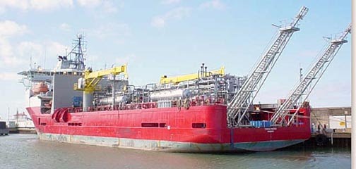
This latter is a Well Testing Service Vessel (WTSV) Dynamic Positioning ship, which has systems for the reception and processing of fluids from well completion, stimulation and repair. For those interested in well flow rates, that measuring capability is among its capabilities.
• Reception of the products from the well via flexible hoses connecting the well to the production system installed on the ship.
• Process and separate water, wasted and un-wasted chemicals, gas, crude oil and solids. The water will be stored in the WTSV’s tanks and later re-injected into industrial waste well or offloaded to a processing facility onshore.
• The crude and gas will be measured in quantity and quality. The combination may be returned to the export line, or if this last is not available, the gas will be flared and the crude stored in the WTSV’s tanks to later be exported to an onshore or an offshore offloading terminal.
• The solids are stored in containers to be disposed to shore.
• Crude ranges are from low to high (12 to 43 °) API. Pressures up to 10,000 psi at the well head.
It has been suggested that it might arrive on site on the 19th June. The Loch Rannoch should arrive a few days earlier, releasing the Drillship Enterprise, which, I suspect, has other things that it might now be doing.
The Toisa Pisces was formerly a cable-laying vessel, and is not a Floating Production, Storage and Offloading unit (FPSO).
My main topic for this post, however, is not the possible change is the fleet over the well, but rather some thoughts on how to avoid this happening again. There were likely a cascade of several errors, each of which alone would not have led to the disaster, but cumulatively they did. So how do we stop it happening again?
In some ways the problem is similar to that the Mining Industry faces after more than twice the number of deaths (29) at the Upper Big Branch Mine in West Virginia in April. In both cases, there were safety concerns reflected in the numbers of citations that the companies had received relative to other companies. So how does one install a different attitude in those who work to produce the fuel that we all need? To a degree, it has to be done through the imposition of regulations that enforce the concept of safety in daily working life. Included in those regulations should be the appropriate recommended practices for carrying out different tasks in the operation.
But even with those regulations in place, they are only as good as the enforcement of them. If my memory serves, you could not become an Inspector of Mines in Britain during the National Coal Board years, unless you had a First Class Certificate of Competency (which is the examination that allows you to manage a mine). The standards of education and training for inspectors must be high, and they need to require a reputable image.
The problems, in part, for both industries, are that the fossil industry historically has been cyclic in nature. Often driven by the price of oil, when that price is high, there are lots of jobs, and both coal and oil boom. The price falls, times get tight, and lots of folk get laid off. It has happened more than once in my career, as we have students go from having many job offers, to students coming back for graduate degrees because there was no work in the industry. The employees that are laid off go find work in other, less cyclic industries.
And so when the next boom comes around, they are no longer available. Furthermore, the teaching departments at the Universities have closed. It is as a result of this boom and bust cycle that there is a dearth of middle management in many companies that work in the fossil fuel business. For many years, they were not hiring, and the folk that they now need as long-time trained and experienced individuals do not exist in large numbers.
The number of both mining and petroleum engineering schools have fallen, and student enrollments, until the recent rise in the price of oil (the $140 one) were bringing other departments closer to that action. At one time, for example, Leeds University in the UK had one of the largest mining departments. At that time, it was housed in a building that was funded by those in the Industry in 1928. That building is now occupied by the Art Department and somewhere – not quite sure where (this from the alumni office and the secretary in the building that houses the remaining odd faculty member) – there is still someone that teaches the odd course (he was out). There is only one other Mining School in the UK, and it studies hard rock mining at Exeter (used to be Cambourne School of Mines).

It is hard to criticize University leaders, who must look to where the students are, and which faculty hire will bring the best return to the University. In recent years that has not been within the ability of the fossil fuel departments, and so they are closing – though the demand for their product is now rising again.
It is one of those interesting items to note that the latest reviews of world oil supply are beginning to suggest, increasingly, that the world is approaching if not past the point of peak global oil production. That will require more mining and petroleum engineers, though at places like Leeds (my alma mater), they will likely only be able to produce the modern version of Thomas Hair, to record the modern version of his “Art of Mining,” rather than the subjects of that art.
So what does all this have to do with regulation and responsibility? Well, it is very difficult to maintain high quality folk in industries that go through severe manpower cycles. When regulations are severely enforced under one administration and then almost neglected in another, either because the industry is in disfavor, or the apple of the administration’s eye, it is hard to keep the regulatory inspectorate that is a vital part of running a safe industry. The regulations should be fair, be strict, and must be enforced by individuals that have been properly trained to a high level of understanding as to both the technology that they are reviewing and the consequences of error.
Historical evidence is clear that Universities cannot be left alone to provide that education, and supply those individuals. The National Mine Health and Safety Academy at Beckley is a start in the right direction for the mining industry, but there are other changes that must be made, in the investment in research into new technology, in the general attitude to those who work to provide the fuels that we need (and will continue to do so).
Treating the industries and those who work in them as pariahs is not the way to solve this problem.
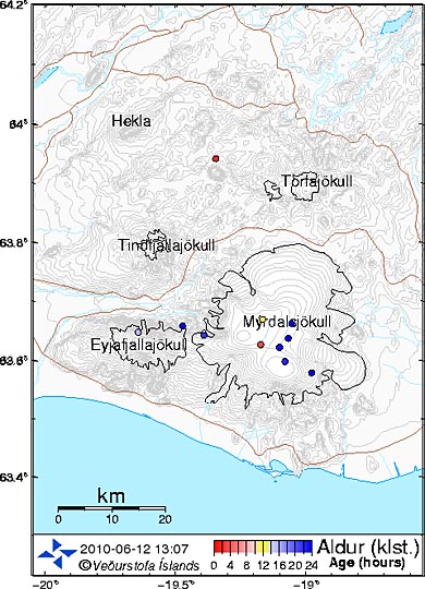
Oh, and not to get anyone excited, but for the first time in the recent past there is some earthquake activity under the Myrdalsjokull glacier in Iceland, the home of the Katla volcano. The map shows the age of recent earthquakes. Eyjafjallajokull is the site of the currently active volcano.
Contact
- Content: editors at theoildrum dot com
- Tech support: support at theoildrum dot com
License

This work is licensed under a Creative Commons Attribution-Share Alike 3.0 United States License.
Prof. Goose's comment:
A continued humble and sincere thank you to all who have donated thus far. It will help us pay for the fourth server we brought online to accommodate the increased traffic. (See point 3 below.)
1. The Oil Drum is a special place. We strive to maintain a high signal to noise ratio in our comment threads. Short, unengaging comments, or comments that are off topic, are likely to be deleted without notice. (to be clear--engaging, on point humor and levity, more than welcome.)
We are trying to perform a service to the public here to coordinate smart people who know their stuff with other people who want to learn about what's going on. Promotion of that ideal will be the criteria by which we make our decisions about what stays and what goes.
Flame wars, polemic exchanges, and other content deleterious to the community will be removed, either by an editor or by the community through its moderation process.
2. If you see a problematic comment USE THE COMMENT MODERATION SYSTEM--see the "Flag as inappropriate" and (?) beside it? Learn more there. If you see comments that are questionable after you've done that (that aren't being removed), let us know at the eds email address.
It is up to this community to enforce the norms we have established here (a high signal to noise ratio), keep. it. up.
Our guide to commenting at TOD can be found here: http://www.theoildrum.com/special/guidelines . Please check it out if you are unfamiliar with it, but it is essentially 1) citations welcome (if not necessary), 2) be kind to others, and 3) be nice to the furniture.
3. We have gotten a lot of queries whether this bump in traffic is adding costs to keep the site functioning. Truth is, yes, we are incurring added expenses from these events. It is also true that we try not to beg from you very often as we are not the types to bother you with constant queries.
That being said, if you are inclined to help out, your support is always welcome and very much appreciated. To those who have already given, thank you very much.
You can find the donate button in the top left hand corner of the main page.
4. If you have come here to vet your plan to kill the well, understand that you will be queried on whether or not you have read the other 10 previous comment threads and all the myriad plans that have already been run by the kind folks in this room; if you have actually read all 10 comment threads and still think your plan has legs, well, then maybe yours really is the one that will save the Gulf of Mexico.
This is not to say that well considered questions about current attempts and modifications to those attempts are not welcome; they are. But try to place them in context and in what's actually going on, as opposed to your MacGyver dream solution where you have a 10 megaton bomb, an ice pick, and Commander Spock at your side.
5. Also, if you're looking for live chat to talk about the ROV/LMRP video, etc., and are IRC capable, go to freenode, the channel is #theoildrum
(google MIRC and download it; Hit the lightening bolt and fill in your info; select the server as "freenode" (it is in the server list), hit connect; when connected type /join #theoildrum)
or you can get there just via a browser: http://webchat.freenode.net / Just enter a nickname and #theoildrum in the boxes; then when connected type /join #theoildrum)
6. Don't be afraid to go back and read the last couple of open threads yesterday and today before you start on this thread. They are really good, and will likely catch you up if you have been out of the loop for a while. We shut down threads when we get to 300-400 comments, as it's really unmanageable. Lots of good stuff in there though.
a vital read:
BP, GIS* And The Mysterious Vanishing Open Letter
* -- Geographic Information System
From the letter's conclusion:
* NIMS = National Incident Management System
In a now closed thread you wrote:
"My, now that is a significant improvement from the masters of transparency and efficacy at the SEC. My hat's off to those wizards."
Did you even bother to read any of the links I sent you? Or did you simply reject them out of hand because you did not understand them?
And I notice how you seemed to be unable to even come up with a competing hypothesis. What is that - because you are nothing but hot air?
I certainly did read the article at the 'seeking alpha' link [and all 10 comments below] and understood the argument put forward that it was a true market adjustment (based on the comparison to the recent lows) and not a 'glitch'. My point was that this is conjecture of a financial blogger based on some simple analysis of price data. The SEC Preliminary Report that you linked is no better - it just proposes some working hypotheses and says they are investigating the matter. In my first post that elicited your responses I said "Interesting that there still isn't a definitive post-mortum on that 'little glitch'." Your links merely confirm this fact.
As for your second post below concerning NIMS and ArcGIS etc - Greenfloyd posted the link to the letter and I posted an excerpt after reading it. I am not sure what point you are trying to make - I have ArcGIS installed on my computer at work and I was working for the USFS in the 1980s when the Incident Command System was first being implemented for inter-agency management of large fires. On the other hand, I have never worked for DHS and I am not a 'GIS jockey'.
I was interested some days ago when you tried to compare (rather inappropriately) the air-space closure for the Station Fire with the restrictions over the oil slick area. Why, exactly did you think they were comparable?
What is the basis for your conjecture that the government is somehow at fault for not implementing ICS procedures for data sharing? I believe the authors of the letter had reached a different conclusion.
You raise the issue of what data might be proprietary - this is a rather important issue and perhaps you could expand on your views. I frankly don't see how any aspect of the surface response could in any way be construed as proprietary and subject to BP's control - their only role should be to pay the bills for it.
Can you provide a link to the source document? I suspect that (like the stock market) - I probably know a _lot_ more about ArcGIS and the NIMS than you do.
Besides - this data should be distributed via the ICS. If there is an issue with data sharing then it is most likely that the federal side of the response has not implemented ICS doctrine.
Another issue here is that even if some of that data is government owned - the rest is propierity to BP. There is a little thing called the 4th Ammendment to the US Constitution bars the government from just waltzing in a taking anythingb they want from a citizen or a corporation.
Dear Activatedb05b,
Not sure you were addressing me, nonetheless, I'm very happy for you and all your knowledge.
The lack of a link is the main reason blogger, Patrick Lockerby, posted what he claims is a "verbatim" copy of the now censored (missing) letter.
As for the 4th Amendment, who here seriously would deny that there is more than enough evidence for warrants to be issued? Doesn't anyone in this administration look at YouTube?
I say, Mr. Obama, bring down that BP fire wall!
I, too, have a copy of it, if folks want it--email me at the eds box. It's a pdf.
"Another issue here is that even if some of that data is government owned - the rest is propierity [sic] to BP. There is a little thing called the 4th Ammendment [sic] to the US Constitution bars the government from just waltzing in a taking anythingb [sic] they want from a citizen or a corporation."
If you're a student of Constitutional law, you are no doubt aware of just what "a little thing" the 4th Amendment has become, of late. But I digress.
What classes or categories of data for, from or about surface and shoreline activities relating to The Gulf Coast Oil Inundation of 2010 do you believe might be proprietary to BP? Indeed, what portion or portions of of said data, in your view, ought *not* to be a matter of public record? Please explain.
Edit: Forgot shoreline.
So you are saying that you understand as much about current ICS doctrine as you do the stock market?
Let me guess - you also dismiss any information about ICS that you don't like just like you did the references I gave you?
BTW - I know a lot about the Station Fire because 1) I live just on the other side of the freeway and 2) my brother is a communications specialist with the Forrest Service working out of the Cleveland National Forrest. (He's retired Navy so you should be able to verify who he is yourself - if you do have the knowelage you claim.)
Activated - I am suggesting a discussion, not a flame war. You raised some issues and I am asking for your views.
I brought up the Station Fire because you had mentioned it in regard to the air closure over the Gulf. My point is that the fire had a huge air show over a 7,000'+ mountain range with retardant planes, spotter and reconnaissance aircraft, helicopters for water drops, transport, IR work, etc. They needed a large airspace cordoned off to ensure safe operations.
The oil slick has no such necessity for air space closure - they just have a few planes for dispersant ops and probably some helicopters for personnel transport. Apples and oranges.
My ex mother-in-law lives in Tujunga and I have worked extensively in the Angeles, Los Padres, and San Bernadino Forests - I know the area reasonably well.
I would be happy if you would care to address the questions I raised. I am interested in your point of view - whether I agree with you about any specific question is not the point.
In the previous version of this thread a video clip was mentioned that was taken by the first ROV at the wellhead, while the rig was still attached (and burning). If that clip is available on the web, can someone post a link? Sounds very interesting...
The link was to the NGS site page for the program:
http://channel.nationalgeographic.com/episode/gulf-oil-spill-5488/Overview
But I can't find the program itself online.
Youtube has some clips of the rig burning but not the underwater footage mentioned:
http://www.youtube.com/watch?v=Fm7Xe3OBzc0
http://www.youtube.com/watch?v=sA6Fx7ZEST0
A still pic is also helpful....
Interesting article on Matt Simmons over at zero hedge (financial blog)
BP As Schrodinger's Cat: Simmons Upgrades Firm To Buy, Seeing It As Both Bankrupt And With $52 Stock Price At Same Time
http://www.zerohedge.com/article/bp-schrodingers-cat-simmons-upgrades-fi...
Matt Simmons is not the CEO of Simmons & Co.
OOPS.
So much for Zero Hedge as a source of investment information.
Speaker to animals , you are quick to put down Zerohedge over one mistake. Many of your other posts are also put downs, why so negative? BTW, how about speaking FOR the animals.
Matt doesn't work at Simmons & Co., and hasn't for some time.
Thought you folks might like to take an oil break and check out this very interesting and possibly very related concept. http://bit.ly/9E9Rek. Don't let the title fool you. This guy is really sharp and this was one of the most fascinating videos I have watched in quite some time.
Groovy, Paul S clever person.
You weren't kidding!
Yeah, Stamets. Wild. Crazy. Genius.
Writes great books and articles, too.
Fascinating indeed - thanks for the link.
It is bad here in Gulf Shores Alabama. It is going to probably get worse. My buddy at the dive shop is worried. I am seeing less and less cleanup folks and more and more oil. Please take notice of what is going on right now.
There is a tiny nickel in there and my foot offers scale. I also have pictures of soon to be out of work Hooter's girls.
http://s892.photobucket.com/albums/ac126/tinfoilhatguy/Gulf%20Shores%206...
If a solar energy guy out in California could be of assistance to any of those poor hooter girls then please do not hesitate to ask.
The only thing that might help us now is Californian Medical Marijuana. Joking aside, no medical or mental health care has been advertised or offered. I am sure the local doctors are on the lookout, but I do not think Gulf Shores even has a psychiatrist, much less one trained extensively in disaster mental issues. That is outrageous. I will try to keep all of you informed. Thanks.
Keep us up to date.....
The national news has been covering Florida, but not Alabama's beaches in details.
Because I posted this earlier at the end of a thread, hope no one minds my reposting:
Just an observation, the offshore surface oil seems to be expanding significantly just the last couple days. On the 10th I saw what appeared to be a large slick on the most recent AQUA MODIS image, around 25N 88.5W (south of the MS/AL border, west of the FL Keys):
http://rapidfire.sci.gsfc.nasa.gov/subsets/?subset=USA7.2010161.aqua.1km...
However at the time the NOAA offshore forecast did not show any oil even close to that location:
http://response.restoration.noaa.gov/book_shelf/2159_SOFM24-2010-06-09-1...
Their more recent updated map expands the offshore area significantly and notes the spill there:
http://response.restoration.noaa.gov/book_shelf/2174_SOFM24-2010-06-11-1...
But there seemed to be nothing in the daily briefings to take note of this.
Based upon firsthand experience, the NOAA maps have been spot on for incursion on the shore. I am thinking the offshore stuff is way more unpredictable and detectable. Judging from the accuracy of the 'shore' map, I am guessing terrestrial backup information from air and water craft is being used. I hope it reassures folks a little about the 'shore' map.
I doubt they would be flying out that far on a regular basis, but who knows. Probably they used the MODIS image in their subsequent update, as well as other satellite imagery.
Checking today's MODIS images, the AQUA pass highlights the huge surface slick in the AL/FL panhandle shoreline area:
http://rapidfire.sci.gsfc.nasa.gov/subsets/?subset=USA7.2010163.aqua.1km
Could someone from the industry point to or post a picture of what a sheared drill pipe end looks like? I found the pic below but don't think it would be the result of the action of the 2 "V" cutters described elsewhere for the bp/cameron bop equipment.
pipe sheared:
http://www.mms.gov/tarprojects/455.htm
possibly by a shear of the bottom picture:
http://petroleumoiltools.com/blowout-preventers/ram-blocks.html
thanks much
I am not in the industry, but I will attempt to answer.
The MMS pictures are from a report where they tested sealing shear rams- the ones that did not work. Looking at a powerpoint presentation from Cameron, the BOP manufacturer, all but the super shears have a rather shallow V. IMHO based on my experience shearing things that the shallow angle would produce the picture shown (indeed those pipes may have been sheared with the same or similar shears). The transocean BOP did not have super shears.
not super shears - thanks.
btw, in looking at that pdf report of the first link, they have a graphic diagram of the shear. don't know how representative it is, but it appears the cutters might seal against an elastomeric block if the severed pipe moves out of the way. maybe that pipe stub is preventing a better seal.
HO - Nice article, thanks, gives the state of the biz, perspective. Too many US industries are in the same state.
And TFH- thanks for the photos. How in-congruent the oil blobs are on that beach.
Yes, but the Hooter girls make effective spokespersons for the economic damage of this event. It really does put a human face to it. One girl is a marine scientist and another a business school graduate. Thanks for your support I am probably going to get a job offer due to all this traffic I am generating. I am trying to do it a helpful, positive way. The videos are heart wrenching.
http://www.doomers.us/forum2/index.php/topic,67380.0.html
Check out these photos and first hand experience with clean up of the spill. From 'megadoom' over at LATOC. You'll have to scroll down a bit to get to his entry.
I've been a silent reader here for years, and am following all that is said with extreme curiosity and concern. Thanks for one of the most intelligent websites ever.
Saturday night thought:
“Grant me chastity and continence, but not yet.” — St. Augustine
Liquidity problems on the horizon?
http://www.sfgate.com/cgi-bin/article.cgi?f=/n/a/2010/06/11/national/a00...
That should be solved by the application of a whole bunch of lawyers and some new taxes. Ok ok, enough sarcasm.
I haven't seen any discussion here of this: http://www.cleveland.com/nation/index.ssf/2010/06/coast_guard_demands_th...
It says that the Coast Guard has demanded a new plan for oil capture in 48 hours.
Frankly, I think we're watching the results of what happens when we have over-beaurocratized everything. BP, the feds, the regulators, everything. And people want more.
That was the failure in Katrina. I know it first hand. I was part of an operation to attempt to restore data and phone services to the areas east of NOLA, and the beaurocracy was all but impenetrable. People and places waited weeks and months for services that could have been provided in days by volunteers. The reason was that beaurocrats had friends in the industry they wanted to steer nice juicy contracts to - some of those were in state, some federal, and some were non-profit agencies.
The USCG demand is in response to BP's estimate that the next step toward capturing more flow won't be ready until mid-July. There is *no* way that a government subject to public pressure to "get this thing stopped" can refrain from cranking up the pressure on BP. Which is fine with me.
We all know they aren't likely to come up with a magic fix, but I'm perfectly happy to have them feeling hot breath on their necks until the very moment this is *all* over.
Probably someone has posted a link to this bit of humor before, but I hadn't seen it:
http://www.youtube.com/watch?v=6IKnpl3eXVA&feature=player_embedded
We don't call it "globalism" for no reason.
http://www.allgov.com/Top_Stories/ViewNews/Who_Owns_BP__Biggest_Sharehol...
Emphasis added.
Yes, they fail to mention this because JPM is the holder, not the owner of these shares. JPM is the approved depositary for BP ADS. When you buy ADS in a foreign company they are held for you at such a bank.
Black Rock, a New York-based asset management firm, holds nearly 6%, (per BP) of the voting rights of the issued shares of the company. But Black Rock is itself a public company. Barclays (British Bank), for instance, owns nearly 20% of Black Rock. As do many other non-US individuals and institutions.
Lesson from all this: BP is a multi-national company. It is British, it is American, it is sleazy Cayman Islands bankers who don't ask questions, Kazakh minister's relatives, Russian mobsters and little old lady pensioners from Swansea, Pasadena and everywhere in between.
JPM is certainly the depositary, and may own BP shares/ADS's for its own account—don't know. IIRC, this was set up to facilitate the Arco/AMOCO swaps.
Anyway, we agree: corporations on this scale don't have national identities or loyalties. I'll bet even the Daily Express knows that, but jingoism sells papers.
The life of British Tabloids: Football scores, girl with big knockers, birdcage lining.
But yeah, it gets too complicated for the simpletons. Not only could JPM own shares (I know that Wells Fargo has a bunch of them, as do other US banks), but look back to the British Petroleum/Amoco merger. There you had a 60%/40% split favoring the "British". But wait! Not all British Petroleum shares then were owned by British entities, and not all Amoco shares were owned by Americans.
Even still, the "Americans" got 40% of the combined company, which of course was called BP Amoco until it bought two other firms: one American; the other British! And the bigger of those two was the American one.
So today there are roughly equal numbers of British and American entities owning BP. Not a simple storyline.
And that befuddled CEO of BP...notice how he's using an American-ism, ("get my life back").
Bernard Shaw used to have it right about the British and the Americans, but not today. Today, we're two different peoples united by a common love of self-pitying Oprah-speak!
http://www.nhc.noaa.gov/index.shtml
BP control over Nat'l Incident Mngt Systems data?
Indicates withholding of data vital to DWH remediation.
See "BP GIS and the Mysterious VanishingOpen Letter", available at:
http://www.scientificblogging.com/chatter_box/bp
Editors' note for first-time visitors: What follows is a comment from a The Oil Drum reader. To read what The Oil Drum staff members are saying about the Deepwater Horizon Spill, please visit the front page.
OK let's get real about the GOM oil flow. There doesn't really seem to be much info on TOD that furthers more complete understanding of what's really happening in the GOM.
As you have probably seen and maybe feel yourselves, there are several things that do not appear to make sense regarding the actions of attack against the well. Don't feel bad, there is much that doesn't make sense even to professionals unless you take into account some important variables that we are not being told about. There seems to me to be a reluctance to face what cannot be termed anything less than grim circumstances in my opinion. There certainly is a reluctance to inform us regular people and all we have really gotten is a few dots here and there...
First of all...set aside all your thoughts of plugging the well and stopping it from blowing out oil using any method from the top down. Plugs, big valves to just shut it off, pinching the pipe closed, installing a new bop or lmrp, shooting any epoxy in it, top kills with mud etc etc etc....forget that, it won't be happening..it's done and over. In fact actually opening up the well at the subsea source and allowing it to gush more is not only exactly what has happened, it was probably necessary, or so they think anyway.
So you have to ask WHY? Why make it worse?...there really can only be one answer and that answer does not bode well for all of us. It's really an inescapable conclusion at this point, unless you want to believe that every Oil and Gas professional involved suddenly just forgot everything they know or woke up one morning and drank a few big cups of stupid and got assigned to directing the response to this catastrophe. Nothing makes sense unless you take this into account, but after you do...you will see the "sense" behind what has happened and what is happening. That conclusion is this:
The well bore structure is compromised "Down hole".
That is something which is a "Worst nightmare" conclusion to reach. While many have been saying this for some time as with any complex disaster of this proportion many have "said" a lot of things with no real sound reasons or evidence for jumping to such conclusions, well this time it appears that they may have jumped into the right place...
TOP KILL - FAILS:
This was probably our best and only chance to kill this well from the top down. This "kill mud" is a tried and true method of killing wells and usually has a very good chance of success. The depth of this well presented some logistical challenges, but it really should not of presented any functional obstructions. The pumping capacity was there and it would have worked, should have worked, but it didn't.
It didn't work, but it did create evidence of what is really happening. First of all the method used in this particular top kill made no sense, did not follow the standard operating procedure used to kill many other wells and in fact for the most part was completely contrary to the procedure which would have given it any real chance of working.
When a well is "Killed" using this method heavy drill fluid "Mud" is pumped at high volume and pressure into a leaking well. The leaks are "behind" the point of access where the mud is fired in, in this case the "choke and Kill lines" which are at the very bottom of the BOP (Blow Out Preventer) The heavy fluid gathers in the "behind" portion of the leaking well assembly, while some will leak out, it very quickly overtakes the flow of oil and only the heavier mud will leak out. Once that "solid" flow of mud is established at the leak "behind" the well, the mud pumps increase pressure and begin to overtake the pressure of the oil deposit. The mud is established in a solid column that is driven downward by the now stronger pumps. The heavy mud will create a solid column that is so heavy that the oil deposit can no longer push it up, shut off the pumps...the well is killed...it can no longer flow.
Usually this will happen fairly quickly, in fact for it to work at all...it must happen quickly. There is no "trickle some mud in" because that is not how a top kill works. The flowing oil will just flush out the trickle and a solid column will never be established. Yet what we were told was "It will take days to know whether it
worked"...."Top kill might take 48 hours to complete"...the only way it could take days is if BP intended to do some "test fires" to test integrity of the entire system. The actual "kill" can only take hours by nature because it must happen fairly rapidly. It also increases strain on the "behind" portion and in this instance we all know that what remained was fragile at best.
Early that afternoon we saw a massive flow burst out of the riser "plume" area. This was the first test fire of high pressure mud injection. Later on same day we saw a greatly increased flow out of the kink leaks, this was mostly mud at that time as the kill mud is tanish color due to the high amount of Barite which is added to it to weight it and Barite is a white powder.
We later learned the pumping was shut down at midnight, we weren't told about that until almost 16 hours later, but by then...I'm sure BP had learned the worst. The mud they were pumping in was not only leaking out the "behind" leaks...it was leaking out of someplace forward...and since they were not even near being able to pump mud into the deposit itself, because the well would be dead long before...and the oil was still coming up, there could only be one conclusion...the wells casings were ruptured and it was leaking "down hole"
They tried the "Junk shot"...the "bridging materials" which also failed and likely made things worse in regards to the ruptured well casings.
"Despite successfully pumping a total of over 30,000 barrels of heavy mud, in three attempts at rates of up to
80 barrels a minute, and deploying a wide range of different bridging materials, the operation did not overcome the flow from the well."
http://www.bp.com/genericarticle.do?categoryId=2012968&contentId=7062487
80 Barrels per minute is over 200,000 gallons per hour, over 115,000 barrels per day...did we seen an increase over and above what was already leaking out of 115k bpd?....we did not...it would have been a massive increase in order of multiples and this did not happen.
"The whole purpose is to get the kill mud down,” said Wells. “We'll have 50,000 barrels of mud on hand to kill this well. It's far more than necessary, but we always like to have backup."
Try finding THAT quote around...it's been scrubbed...here's a cached copy of a quote...
http://webcache.googleusercontent.com/search?q=cache:WDj-HORTmIoJ:www.chron.com/disp/story.mpl/business/deepwaterhorizon/7006870.html+%E2%809CThe+whole+purpose+is+to+get+the+kill+mud+down,%E2%80%9D+said+Wells.+%E2%80%9CWe'll+have+50,000+barrels+of+mud+on+hand+to+kill+this+well.+It's+far+more+than+necessary,+but+we+always+like+to+have+backup.%E2%80%9D&cd=1&hl=en&ct=clnk&gl=us
"The "top kill" effort, launched Wednesday afternoon by industry and government engineers, had pumped enough drilling fluid to block oil and gas spewing from the well, Allen said. The pressure from the well was very low, he said, but persisting."
"Allen said one ship that was pumping fluid into the well had run out of the fluid, or "mud," and that a second ship was on the way. He said he was encouraged by the progress."
http://www.houmatoday.com/article/20100527/ARTICLES/100529348
Later we found out that Allen had no idea what was really going on and had been "Unavailable all day"
http://www.realclearpolitics.com/articles/2010/05/27/interview_with_coas...
So what we had was BP running out of 50,000 barrels of mud in a very short period of time. An amount far and above what they deemed necessary to kill the well. Shutting down pumping 16 hours before telling anyone, including the president. We were never really given a clear reason why "Top Kill" failed, just that it couldn't overcome the well.
There is only one article anywhere that says anything else about it at this time of writing...and it's a relatively obscure article from the wall street journal "online" citing an unnamed source.
"WASHINGTON—BP PLC has concluded that its "top-kill" attempt last week to seal its broken well in the Gulf of
Mexico may have failed due to a malfunctioning disk inside the well about 1,000 feet below the ocean floor.
The disk, part of the subsea safety infrastructure, may have ruptured during the surge of oil and gas up the well on April 20 that led to the explosion aboard the Deepwater Horizon rig, BP officials said. The rig sank two days later, triggering a leak that has since become the worst in U.S. history.
The broken disk may have prevented the heavy drilling mud injected into the well last week from getting far enough down the well to overcome the pressure from the escaping oil and gas, people familiar with BP's findings said. They said much of the drilling mud may also have escaped from the well into the rock formation outside the wellbore.
As a result, BP wasn't able to get sufficient pressure to keep the oil and gas at bay. If they had been able to build up sufficient pressure, the company had hoped to pump in cement and seal off the well. The effort was deemed a failure on Saturday.
BP started the top-kill effort Wednesday afternoon, shooting heavy drilling fluids into the broken valve known as a blowout preventer. The mud was driven by a 30,000 horsepower pump installed on a ship at the surface. But it was clear from the start that a lot of the "kill mud" was leaking out instead of going down into the well."
http://online.wsj.com/article/SB1000142405274870487560457528013357716426...
There are some inconsistencies with this article.
There are no "Disks" or "Subsea safety structure" 1,000 feet below the sea floor, all that is there is well bore. There is nothing that can allow the mud or oil to "escape" into the rock formation outside the well bore except the well, because it is the only thing there.
All the actions and few tid bits of information all lead to one inescapable conclusion. The well pipes below the sea floor are broken and leaking. Now you have some real data of how BP's actions are evidence of that, as well as some murky statement from "BP officials" confirming the same.
I took some time to go into a bit of detail concerning the failure of Top Kill because this was a significant event. To those of us outside the real inside loop, yet still fairly knowledgeable, it was a major confirmation of what many feared. That the system below the sea floor has serious failures of varying magnitude in the complicated chain, and it is breaking down and it will continue to.
What does this mean?
It means they will never cap the gusher after the wellhead. They cannot...the more they try and restrict the oil gushing out the bop?...the more it will transfer to the leaks below. Just like a leaky garden hose with a nozzle on it. When you open up the nozzle?...it doesn't leak so bad, you close the nozzle?...it leaks real bad,
same dynamics. It is why they sawed the riser off...or tried to anyway...but they clipped it off, to relieve pressure on the leaks "down hole". I'm sure there was a bit of panic time after they crimp/pinched off the large riser pipe and the Diamond wire saw got stuck and failed...because that crimp diverted pressure and flow to the rupture down below.
Contrary to what most of us would think as logical to stop the oil mess, actually opening up the gushing well and making it gush more became direction BP took after confirming that there was a leak. In fact if you note their actions, that should become clear. They have shifted from stopping or restricting the gusher to opening it up and catching it. This only makes sense if they want to relieve pressure at the leak hidden down below the seabed.....and that sort of leak is one of the most dangerous and potentially damaging kind of leak there could be. It is also inaccessible which compounds our problems. There is no way to stop that leak from above, all they can do is relieve the pressure on it and the only way to do that right now is to open up the nozzle above and gush more oil into the gulf and hopefully catch it, which they have done, they just neglected to tell us why, gee thanks.
A down hole leak is dangerous and damaging for several reasons.
There will be erosion throughout the entire beat up, beat on and beat down remainder of the "system" including that inaccessible leak. The same erosion I spoke about in the first post is still present and has never stopped, cannot be stopped, is impossible to stop and will always be present in and acting on anything that is left which has crude oil "Product" rushing through it. There are abrasives still present, swirling flow will create hot spots of wear and this erosion is relentless and will always be present until eventually it wears away enough material to break it's way out. It will slowly eat the bop away especially at the now pinched off riser head and it will flow more and more. Perhaps BP can outrun or keep up with that out flow with various suckage methods for a period of time, but eventually the well will win that race, just how long that race will be?...no one really knows....However now?...there are other problems that a down hole leak will and must produce that will compound this already bad situation.
This down hole leak will undermine the foundation of the seabed in and around the well area. It also weakens the only thing holding up the massive Blow Out Preventer's immense bulk of 450 tons. In fact?...we are beginning to the results of the well's total integrity beginning to fail due to the undermining being caused by the leaking well bore.
The first layer of the sea floor in the gulf is mostly lose material of sand and silt. It doesn't hold up anything and isn't meant to, what holds the entire subsea system of the Bop in place is the well itself. The very large steel connectors of the initial well head "spud" stabbed in to the sea floor. The Bop literally sits on top of the pipe and never touches the sea bed, it wouldn't do anything in way of support if it did. After several tens of feet the seabed does begin to support the well connection laterally (side to side) you couldn't put a 450 ton piece of machinery on top of a 100' tall pipe "in the air" and subject it to the side loads caused by the ocean currents and expect it not to bend over...unless that pipe was very much larger than the machine itself, which you all can see it is not. The well's piping in comparison is actually very much smaller than the Blow Out Preventer and strong as it may be, it relies on some support from the seabed to function and not literally fall over...and it is now showing signs of doing just that....falling over.
If you have been watching the live feed cams you may have noticed that some of the ROVs are using an inclinometer...and inclinometer is an instrument that measures "Incline" or tilt. The BOP is not supposed to be tilting...and after the riser clip off operation it has begun to...
This is not the only problem that occurs due to erosion of the outer area of the well casings. The way a well casing assembly functions it that it is an assembly of different sized "tubes" that decrease in size as they go down. These tubes have a connection to each other that is not unlike a click or snap together locking action. After a certain length is assembled they are cemented around the ouside to the earth that the more rough drill hole is bored through in the well making process. A very well put together and simply explained process of "How to drill a deep water oil well" is available here:
http://www.treesfullofmoney.com/?p=1610
The well bore casings rely on the support that is created by the cementing phase of well construction. Just like if you have many hands holding a pipe up you could put some weight on the top and the many hands could hold the pipe and the weight on top easily...but if there were no hands gripping and holding the pipe?...all the weight must be held up by the pipe alone. The series of connections between the sections of casings are not designed to hold up the immense weight of the BOP without all the "hands" that the cementing provides and they will eventually buckle and fail when stressed beyond their design limits.
These are clear and present dangers to the battered subsea safety structure (bop and lmrp) which is the only loose cork on this well we have left. The immediate (first 1,000 feet) of well structure that remains is now also undoubtedly compromised. However.....as bad as that is?...it is far from the only possible problems with this very problematic well. There were ongoing troubles with the entire process during the drilling of this well. There were also many comprises made by BP IMO which may have resulted in an overall weakened structure of the entire well system all the way to the bottom plug which is over 12,000 feet deep. Problems with the cementing procedure which was done by Haliburton and was deemed as “was against our best practices.” by a Haliburton employee on April 1st weeks before the well blew out. There is much more and I won't go into detail right now concerning the lower end of the well and the troubles encountered during the whole creation of this well and earlier "Well control" situations that were revieled in various internal BP e-mails. I will add several links to those documents and quotes from them below and for now, address the issues concerning the upper portion of the well and the region of the sea floor.
What is likely to happen now?
Well...none of what is likely to happen is good, in fact...it's about as bad as it gets. I am convinced the erosion and compromising of the entire system is accelerating and attacking more key structural areas of the well, the blow out preventer and surrounding strata holding it all up and together. This is evidenced by the tilt of the blow out preventer and the erosion which has exposed the well head connection. What eventually will happen is that the blow out preventer will literally tip over if they do not run supports to it as the currents push on it. I suspect they will run those supports as cables tied to anchors very soon, if they don't, they are inviting disaster that much sooner.
Eventually even that will be futile as the well casings cannot support the weight of the massive system above with out the cement bond to the earth and that bond is being eroded away. When enough is eroded away the casings will buckle and the BOP will collapse the well. If and when you begin to see oil and gas coming up around the well area from under the BOP? or the area around the well head connection and casing sinking more and more rapidly? ...it won't be too long after that the entire system fails. BP must be aware of this, they are mapping the sea floor sonically and that is not a mere exercise. Our Gov't must be well aware too, they just are not telling us.
All of these things lead to only one place, a fully wide open well bore directly to the oil deposit...after that, it goes into the realm of "the worst things you can think of" The well may come completely apart as the inner liners fail. There is still a very long drill string in the well, that could literally come flying out...as I said...all the worst things you can think of are a possibility, but the very least damaging outcome as bad as it is, is that we are stuck with a wide open gusher blowing out 150,000 barrels a day of raw oil or more. There isn't any "cap dome" or any other suck fixer device on earth that exists or could be built that will stop it from gushing out and doing more and more damage to the gulf. While at the same time also doing more damage to the well, making the chance of halting it with a kill from the bottom up less and less likely to work, which as it stands now?....is the only real chance we have left to stop it all.
It's a race now...a race to drill the relief wells and take our last chance at killing this monster before the whole weakened, wore out, blown out, leaking and failing system gives up it's last gasp in a horrific crescendo.
We are not even 2 months into it, barely half way by even optimistic estimates. The damage done by the leaked oil now is virtually immeasurable already and it will not get better, it can only get worse. No matter how much they can collect, there will still be thousands and thousands of gallons leaking out every minute, every hour of every day. We have 2 months left before the relief wells are even near in position and set up to take a kill shot and that is being optimistic as I said.
Over the next 2 months the mechanical situation also cannot improve, it can only get worse, getting better is an impossibility. While they may make some gains on collecting the leaked oil, the structural situation cannot heal itself. It will continue to erode and flow out more oil and eventually the inevitable collapse which cannot be stopped will happen. It is only a simple matter of who can "get there first"...us or the well.
We can only hope the race against that eventuality is one we can win, but my assessment I am sad to say is that we will not.
The system will collapse or fail substantially before we reach the finish line ahead of the well and the worst is yet to come.
Sorry to bring you that news, I know it is grim, but that is the way I see it....I sincerely hope I am wrong.
We need to prepare for the possibility of this blow out sending more oil into the gulf per week then what we already have now, because that is what a collapse of the system will cause. All the collection efforts that have captured oil will be erased in short order. The magnitude of this disaster will increase exponentially by the time we can do anything to halt it and our odds of actually even being able to halt it will go down.
The magnitude and impact of this disaster will eclipse anything we have known in our life times if the worst or even near worst happens...
We are seeing the puny forces of man vs the awesome forces of nature.
We are going to need some luck and a lot of effort to win...
and if nature decides we ought to lose, we will....
Reference materials:
On April 1, a job log written by a Halliburton employee, Marvin Volek, warns that BP’s use of cement “was
against our best practices.”
An April 18 internal Halliburton memorandum indicates that Halliburton again warned BP about its practices,
this time saying that a “severe” gas flow problem would occur if the casings were not centered more carefully.
Around that same time, a BP document shows, company officials chose a type of casing with a greater risk of
collapsing.
http://www.nytimes.com/2010/06/06/us/06rig.html?pagewanted=1&sq=at_issue...
Mark Hafle, the BP drilling engineer who wrote plans for well casings and cement seals on the Deepwater
Horizon's well, testified that the well had lost thousands of barrels of mud at the bottom. But he said models
run onshore showed alterations to the cement program would resolve the issues, and when asked if a cement
failure allowed the well to "flow" gas and oil, he wouldn't capitulate.
Hafle said he made several changes to casing designs in the last few days before the well blew, including the
addition of the two casing liners that weren't part of the original well design because of problems where the
earthen sides of the well were "ballooning." He also worked with Halliburton engineers to design a plan for
sealing the well casings with cement.
http://www.nola.com/news/gulf-oil-spill/index.ssf/2010/05/hearings_bp_ce...
graphic of fail
http://media.nola.com/news_impact/other/oil-cause-050710.pdf
Casing joint
http://www.glossary.oilfield.slb.com/files/OGL00001.gif
Casing
http://www.glossary.oilfield.slb.com/files/OGL00003.gif
Kill may take until Christmas
http://preview.bloomberg.com/news/2010-06-02/bp-gulf-of-mexico-oil-leak-...
BP Used Riskier Method to Seal Well Before Blast
http://www.nytimes.com/2010/05/27/us/27rig.html
BP memo test results
http://energycommerce.house.gov/Press_111/20100512/Internal.BP.Email.Reg...
Investigation results
The information from BP identifies several new warning signs of problems. According to BP there were three flow
indicators from the well before the explosion.
http://energycommerce.house.gov/documents/20100525/Memo.BP.Internal.Inve...
BP, what we know
http://energycommerce.house.gov/documents/20100512/BP-What.We.Know.pdf
What could have happened
1. Before or during the cement job, an influx of hydrocarbon enters the wellbore.
2. Influx is circulated during cement job to wellhead and BOP.
3. 9-7/8” casing hanger packoff set and positively tested to 6500 psi.
4. After 16.5 hours waiting on cement, a negative test performed on wellbore below BOP.
(~ 1400 psi differential pressure on 9-7/8” casing hanger packoff and ~ 2350 psi on
double valve float collar)
5. Packoff leaks allowing hydrocarbon to enter wellbore below BOP. 1400 psi shut in
pressure observed on drill pipe (no flow or pressure observed on kill line)
6. Hydrocarbon below BOP is unknowingly circulated to surface while finishing displacing
the riser.
7. As hydrocarbon rises to surface, gas break out of solution further reduces hydrostatic
pressure in well. Well begin to flow, BOPs and Emergency Disconnect System (EDS)
activated but failed.
8. Packoff continues to leak allowing further influx from bottom.
Confidential
http://energycommerce.house.gov/documents/20100512/BP-What.Could.Have.Ha...
T/A daily log 4-20
http://energycommerce.house.gov/documents/20100512/TRO-Daily.Drilling.Re...
Cement plug 12,150 ft SCMT logging tool
SCMT (Slim Cement Mapping Tool)
Schlumberger Partial CBL done.
http://energycommerce.house.gov/documents/20100530/BP-HZN-CEC018441.pdf
Schlum CBL tools
http://www.slb.com/~/media/Files/production/product_sheets/well_integrit...
Major concerns, well control, bop test.
http://energycommerce.house.gov/documents/20100530/BP-HZN-CEC018375.pdf
Energy & commerce links to docs.
http://energycommerce.house.gov/index.php?option=com_content&view=articl...
well head on sea floor
http://nca-group.com/bilder//Trolla/A.%20GVI%20of%20Trolla%20prior%20to%20WHP002%20(2).jpg
Well head on deck of ship
http://nca-group.com/bilder//Trolla/DSC_0189.JPG
BP's youtube propoganda page, a lot of rarely seen vids here....FWIW
http://www.youtube.com/user/DeepwaterHorizonJIC
http://www.godlikeproductions.com/forum1/message1097505/pg1
Has anybody else been watching the Viking Poseidon ROV 1 feed over the past 30 minutes or so? As far as I can tell, it's monitoring oil seeping out of the seafloor. I hope I'm wrong...
Hard to capture the oil puffs in still photos, but here are two screencaps for comparison. In the second, you can see a couple of black clouds that weren't there in the first photo.


The Viking Poseidon appears to be mapping the debris field of the Deepwater Horizon wreckage. While the idea that the well has suffered a complete internal blowout and is communicating with the seabed is a scary one, I think it's more likely that this ROV is just finding stuff that leaks in that debris. The screen caps above sure look like disturbed seabed - whether by wreckage falling or something else I don't know.
There was an ROV a few days ago doing a task labelled "seabed integrity scan". I haven't heard of anything coming up on that - have you?
"While the idea that the well has suffered a complete internal blowout and is communicating with the seabed is a scary one, I think it's more likely that this ROV is just finding stuff that leaks in that debris."
It was certainly flying around and about debris and over disturbed seabed, when I looked. I didn't have the UTM coordinates of the DWH wreckage handy, so I couldn't check that.
What I saw suggested, as I said, "billowing" and "puffs" of material that looked alternately like methane and methane-with-crude. I am now a full-fledged expert ;^) at identifying silt clouds kicked up by ROV thrusters, and that's not what I saw. It appeared to be escaping under some pressure, although nothing like the pressure at the riser, of course. And, it was intermittent.
I'm sure there are scenarios in which product retained in pressurized, but slightly-breached, compartments in the wreckage might be "burping" these materials. And others I haven't thought of because I'm too ignorant to imagine them without guidance. However, this was the first time I've seen the kind of activity that others have been reporting with some frequency. I've always looked and reported, negatively, before, so I felt compelled to report otherwise this time.
I looked. I've tried to do so every time someone has suggested that a ROV camera was showing seafloor seepage, etc.
In the past few minutes, for the first time, I've actually seen what looks as if it might be methane and some crude billowing and seeping from the seabed. Not constantly, but...
And it certainly *seems* that VP ROV 1 is repeatedly surveying the floor, over a relatively small area.
I dunno. Experts, please look, if you're awake.
ROV 1 pic is a 'loop of nothing' with time stopped at 02.59.37. I guess we saw too much.
I saw this last night too. The crack they were observing looked similar to that in your screen capture. They had a much better image last night. Water/Silt/Oil? appeared to puff out of the crack every few seconds.
Dougr:
Of all the amazing posts/articles I've read lately about the GOM oil "leak", yours is the first one that has made me finally see what the O&G industry pros have been worrying about. What you wrote is comprehensible to me and I didn't know squat about oil and drilling a few weeks ago. I've just got to say that TOD is absolutely the most amazing website I've ever spent any time on (and was on the Web before it was really a "web"). Thanks to you for this post! I'll fade back into the woodwork now.
Thankyou Dougr
I have been reading here a little while, and have long been wanting to know what a true 'worst case scenario' might be.
If the sequence of events you have outlined come to pass and bottom kill fails, what are the options available?
Is there a process that could be used to collapse the well with a prospect of success? I know that this has been discusssed at TOD before, and largely discounted, but in the circumstances you outline would this now become a viable option?
Could releif wells be converted to production wells with a view to trying to empty this field, fast? If this were to be a viable option, should they be starting to drill more wells now if this events you outline are a realistic or even probable scenario?
Are there any other options?
dougr wrote....
" There are no "Disks" or "Subsea safety structure" 1,000 feet below the sea floor, all that is there is well bore. "
I've been curious about this. Would somebody like to explain why the well drawing lists several " 16" rupture/burst disks", including one 1000' below sea floor at 6047'. What exactly are they describing?. I understand how such disks could protect the casing from pressure differentials, is that their purpose?.
http://www.energy.gov/open/documents/3.1_Item_2_Macondo_Well_07_Jun_1900...
Given that this information has been around a while, if you don't mind, I think I'll keep taking guidance from other posters here, such as Rockman, Ali, HO etc. as they offer perceptions from experience.
Dougr excellent analysis. I've been waiting weeks for this as I could not understand what Matt Simmons was talking about. I hope that we can start protecting the great lakes for this maybe the last refuge.
Thanks dougr, for the comprehensive wrap up.
I hope you are wrong, but I fear you are not.
Everything that happended so far and and everything that currently is going on proofs you are right.
Interesting. I can't say and really don't know what to say re your posting.
A month or so before this BP issue I watched the old nuclear disaster movie "On The Beach" on TCN.
From day 1 of this event I've had the distinct feeling that we were now experiencing something similar to that old movie.
If what you are describing is even close to reality then we might be in for 5-10 years of oil flow at say 200,000 barrels a day. That'd ... well, no point going further.
Maybe multiple production wells would be the solution if you are correct??? I don't know.
Has anyone been taking note of what the inclinometer shows?
Any links to old pics would be useful, so that we can maybe see whether the tilt is increasing when the ROVs start paying attention to it again.
Just a couple of points.
You write "There are no "Disks" or "Subsea safety structure" 1,000 feet below the sea floor, all that is there is well bore. There is nothing that can allow the mud or oil to "escape" into the rock formation outside the well bore except the well, because it is the only thing there."
There are actually 3 off what are described as 16 inch rupture/burst discs at 6047', 8304' and 9560'. Also there is a production casing. http://www.energy.gov/open/documents/3.1_Item_2_Macondo_Well_07_Jun_1900...
It was widely reported at the time that the US administration ordered the top kill to be ceased in case it made the situation worse.
Anyone know anything much about SHR @ Godlike Productions?
I know that s/he is listed as the forum administrator there, and that the site banner describes their interests:
I know that his/her post on the Macondo gusher, at 2:30 a.m on 6/12 (in some time zone), is a near-duplicate of dougr's recent post to this thread.
I know that a user identified as "Quorum" recently posted this:
I noticed that my Mac Pro with dual quad core Nehalem processors and 16 gigs of RAM slows to a crawl and spins the bad news beach ball when I visit.
Other than that, no. Do we need to know more?
This is one of the best posts I have seen on TOD - very high praise indeed. It has the ring of truth about it and assembles most of the facts into a coherent and frighteningly plausible narrative. I am sure there are holes to be picked but to me as an engineer the overall thrust is compelling. I look forward apprehensively to reading comments by Rockman and your other knowledgeable posters.
Hello all,
Following the spill fairly regularly (and a lot on this site), must say I'm a bit confused as to its status as well as the reporting from MSM
1) About the extend of the spill : We now hear that the leak would be one Exxon Valdez every 5 days, however the "surface slick maps" do not change that much or were even bigger at the beginning, is it the result of the dispersant being really effective ?
2) Here, and also a lot in the media, the focus is on plugging the leak, but we don't get much from what happens on the shores, and on the surface, on the shores is it that no massive amount has reach them ? Again dispersant being effective ? How about on the surface offshore, here again almost no reporting, few videos always the same, are small planes forbidden to survey extend of the spill ?
5:24EDT. Anyone else looking at Boa Deep C : ROV 1?
Working the manifold, prepping for production from choke & kill lines?