| Drumbeat: June 29, 2010 | The Oil Drum | BP's Deepwater Horizon - More Insights Relating to DougR's Comment and Flow Rates |
Storm Watch, 29 June 2010
Posted by methaz on June 29, 2010 - 10:25am
4pm Update
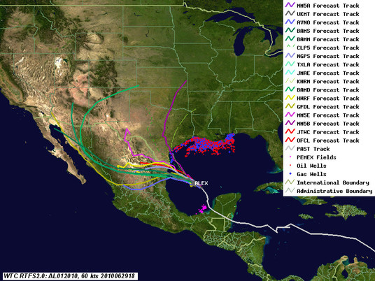
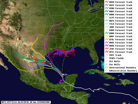
Model guidance continues to converge on the Northern Mexico coast. Alex may be a minimum hurricane now, but has not blossomed as many forecasters were expecting - looks like the models were right about that, at least. The last few hours the storm has been wobbling almost due west - look for NHC to adjust the track a bit south at 5pm.
As noted below, other than the precautionary shut in's, we are not expecting any significant damage to energy production from this storm. As for the Deepwater Horizon response, connection of additional oil capture capacity is being delayed by waves. The waves are already causing problems for the oil spill cleanup efforts, with the Coast Guard recalling all of the skimmer boats. I expect further problems from the waves in the form of damaged and overtopped protective booms, and for oil to wash up in previously untouched areas due to wave induced longshore currents. While there may be some mixing and dispersion, I think Alex is causing more harm than good.
This will be the last special post on Alex unless something weird happens. See you next time!
Original Post
As of 7am ET, Alex is just short of hurricane strength, moving slowly northwest, and continues to develop slowly. It should be declared a hurricane later today. Track guidance has consolidated somewhat, with most of the reliable models showing landfall in northern Mexico or South Texas. Hurricane Warning are now up for these coasts (Note that this year Warnings are issued at 36 hours - in previous years, a "warning" was not issued until the storm was 24 hours out). A turn more westward is anticipated today or tomorrow. There is still some uncertainty as to when and how sharp that turn will be. The two yellow lines in the map below are NHC's main computer models - with the red official track splitting the difference. Alex may reach Category 2 strength (winds near 100mph) before landfall.
There is now very little to no chance the storm will significantly impact either the relief wells or capture efforts at the Deepwater Horizon site. The waves and winds may slow things down a little, but not seriously. Cleanup efforts will certainly be adversely impacted by waves for several days. The question is how bad, and that depends on how strong Alex becomes, and the exact track. It is likely the Gulf will be churned up for a few days. Even relatively small (3ft) waves are rough on protective barriers like booms, and make skimming difficult. The swell can also induce currents in the near shore area, which will move the oil around without dispersing or mixing it. Production impact discussion is below the fold - bottom line, some short term shut in, no long term damage.
Estimated Production Impact
On the current tracks, we (Kinetic Analysis Corporation) do not expect any long term impact on either production or refining. Peak shut in for oil is estimated at about 10%, Natural Gas 15%, of daily production. Numerous companies have evacuated personnel and made precautionary shutdown on the offshore fields south of Corpus Christi Texas. Our models show only minor damage potential, and that on older facilities. (By the way, for those new to oil/gas discussions, the term "shut in" is used because the production isn't really "lost", it's just "shut in" to the ground while we wait for the storm to pass and the facilities repaired. We'll get it out eventually - just not when we want it.) PEMEX stopped exports from some terminals, but apparently there was no production impact.
We'll update this thread during the day as conditions warrant.
Contact
- Content: editors at theoildrum dot com
- Tech support: support at theoildrum dot com
License

This work is licensed under a Creative Commons Attribution-Share Alike 3.0 United States License.
I should get my butt kicked for asking this, but does anybody know how to find the tides for Gulf Shores, AL 36542. I admit it, I do not know everything or it all changes too much and too fast.
NOAA's tide and currents site is a good resource:
http://tidesandcurrents.noaa.gov/
Thanks. 1 pm high tide. Look for photos by 3:30 or so.
Thanks methaz. seo yarışması
According to Bloomberg, Alex may result in some delays in additional oil collection:
they WERE to be done by June 7th? So that means what, June 14th now?
I thought it took a couple days and they can start probably tomorrow night as this thing makes landfall.
Over at MoJo, Julia Whitty's Science of the Spill: 28 June 2010 includes this:
So . . . is it ludicrous to wonder whether this year's hurricanes could be marginally-better help to us and the Gulf biota than Corexit is? (Andrew survivor here, so I know what I'm asking.)
I talked about that in this thread. In theory there are completing processes, but the bottom line is that the slick will have no perceptible impact on a storm. But storms will have (obviously) big impacts on the slick. The Alex situation, while not worst case, is not a good one - strong and close enough to produce long period waves (swell), not close enough to create short-period wind waves that would produce significant off-shore mixing or heavy rain bands to wash stuff out. I really think a direct hit by a nice, wet Cat 1 storm would be great for cleaning things out (if we can schedule it after the well is capped!).
Right-o, methaz. I saw that previous post and have been pulling for a parade of Cat 1s (that all miraculously dissipate a mile offshore) ever since. I'm afraid my scenario may not work out, quite, but I guess this year may give the meteorology grad students as much fodder as the biochemists, so we got that "going for us."
Thanks for your reply.
Hurricane Alex pressure recorded recently as 959 mb. Incredibly low for a Cat 1.
Possibly a Cat 2 soon but not officially yet.
Product: Air Force Vortex Message (URNT12 KNHC)
Transmitted: 30th day of the month at 10:42Z
Aircraft: Air Force Aircraft (Last 3 digits of the tail number are 306)
Storm Number & Year: 01L in 2010
Storm Name: Alex (flight in the North Atlantic basin)
Mission Number: 11
Observation Number: 10
A. Time of Center Fix: 30th day of the month at 10:27:00Z
B. Center Fix Coordinates: 23°22'N 95°07'W (23.3667N 95.1167W) (View map)
B. Center Fix Location: 232 miles (373 km) to the SE (140°) from Brownsville, TX, USA.
C. Minimum Height at Standard Level: 1,063m (3,488ft) at 850mb
D. Estimated (by SFMR or visually) Maximum Surface Wind: 58kts (~ 66.7mph)
E. Location of the Estimated Maximum Surface Wind: 13 nautical miles (15 statute miles) to the SE (138°) of center fix
F. Maximum Flight Level Wind Inbound: From 208° at 67kts (From the SSW at ~ 77.1mph)
G. Location of Maximum Flight Level Wind Inbound: 74 nautical miles (85 statute miles) to the SE (135°) of center fix
H. Minimum Sea Level Pressure: 959mb (28.32 inHg)
I. Maximum Flight Level Temp & Pressure Altitude Outside Eye: 16°C (61°F) at a pressure alt. of 1,521m (4,990ft)
J. Maximum Flight Level Temp & Pressure Altitude Inside Eye: 22°C (72°F) at a pressure alt. of 1,522m (4,993ft)
K. Dewpoint Temp (collected at same location as temp inside eye): 18°C (64°F)
K. Sea Surface Temp (collected at same location as temp inside eye): Not Available
L. Eye Character: Open in the northeast
M. Eye Shape & Diameter: Circular with a diameter of 10 nautical miles (12 statute miles)
N. Fix Determined By: Penetration, Radar, Wind, Pressure and Temperature
N. Fix Level: 850mb
O. Navigation Fix Accuracy: 0.02 nautical miles
O. Meteorological Accuracy: 1 nautical mile
Remarks Section:
Maximum Flight Level Wind: 82kts (~ 94.4mph) in the northeast quadrant at 8:33:40Z
Maximum Flight Level Wind Outbound: 72kts (~ 82.9mph) in the northwest quadrant at 10:29:40Z
But look at the flight level winds - no where near Cat 2 if reduced to the surface. Could be a bad dropsonde. Remember that these vortex messages (and any other raw data, for that matter) are subject to instrument problems and data transmission glitches. No single measurement should be used to judge what's going on in the storm - you have to look at the big picture and integrate all of the available data.
Latest reading 961mb. Still incredibly low for a Cat 1.
Alex approaching land with just a few hours to go. Just below Cat 2 (3 kts below)
000
WTNT41 KNHC 302036
TCDAT1
HURRICANE ALEX DISCUSSION NUMBER 21
NWS TPC/NATIONAL HURRICANE CENTER MIAMI FL AL012010
400 PM CDT WED JUN 30 2010
AFTER A FEW HOURS OF A TRACK BETWEEN NORTH-NORTHWEST AND NORTHWEST
EARLIER TODAY...AIRCRAFT...SATELLITE AND RADAR FIXES INDICATE THAT
ALEX HAS TURNED BACK TO THE WEST AT AN AVERAGE SPEED OF ABOUT 11
KNOTS. THE RIDGE THAT WAS ANTICIPATED TO BUILD NORTH OF THE
HURRICANE HAS MATERIALIZED AND IS NOW FORCING ALEX TO TAKE A LEFT
TURN DIRECTLY TOWARD THE COAST OF MEXICO. THE RIDGE IS FORECAST TO
PERSIST AND ALEX SHOULD MAINTAIN THIS GENERAL WESTWARD TRACK FOR
THE NEXT DAY OR TWO UNTIL DISSIPATION OVER MEXICO
ALEX IS A LARGE HURRICANE AND BOTH HURRICANE AND TROPICAL STORM
FORCE WINDS EXTEND A GREAT DISTANCE FROM THE CENTER. ONLY A SMALL
DEVIATION TO THE NORTH OF THE TRACK...LIKE THE ONE THAT OCCURRED
THIS MORNING...WILL BRING HURRICANE FORCE WINDS TO THE SOUTHERN
TEXAS COAST. THEREFORE...WE WOULD RATHER KEEP THE HURRICANE
WARNINGS FOR THIS PORTION OF THE TEXAS COAST AT THIS TIME.
SATELLITE IMAGES AND DATA FROM THE HURRICANE HUNTER AIRCRAFT
INDICATE THAT ALEX IS BETTER ORGANIZED...AND THAT THE
WINDS HAVE INCREASED. THE MAXIMUM FLIGHT LEVEL WINDS REPORTED SO FAR
ARE 96 KNOTS AND SFMR REPORTED 81 KNOTS TO THE NORTHWEST OF THE
CENTER. IN ADDITION...THE EYE HAS BECOME DISTINCT ON VISIBLE IMAGES
AND IS SURROUNDED BY A CIRCULAR AREA OF DEEP CONVECTION. BASED ON
THESE DATA...THE INITIAL INTENSITY HAS BEEN INCREASED TO 80 KNOTS.
ENVIRONMENTAL CONDITIONS COULD ALLOW ALEX TO BECOME A CATEGORY TWO
HURRICANE BEFORE LANDFALL.
FORECAST POSITIONS AND MAX WINDS
INITIAL 30/2100Z 24.5N 96.8W 80 KT
12HR VT 01/0600Z 24.5N 98.0W 60 KT...INLAND
24HR VT 01/1800Z 24.5N 100.0W 30 KT...INLAND
36HR VT 02/0600Z 24.5N 102.5W 25 KT...DISSIPATING INLAND
48HR VT 02/1800Z...DISSIPATED
Deleted
http://www.latimes.com/news/nationworld/nation/sc-dc-oil-spill-pipes-201...
Second pipe may have crippled BP well's defense mechanism