Hurricane Katrina Update: The Event that Introduces Peak Oil to a Nation
Posted by Prof. Goose on August 29, 2005 - 4:35am
The map above is old, but gives perspective on location of certain key landmarks and fields, this post was originally put up 26 AUG and updated throughout.
Update [2005-8-29 4:40:26 by Prof. Goose]:Katrina at landfall high Cat 4 at 145 mph winds, 918 mb. (Compare: Andrew 922 mb, Camille 909 mb, low being worse). Storm surge tough to predict, but projected around 18ft. Predictions indicate a 30-40 mile wide, 6-10 hour storm hover over New Orleans, though it will be on the "better" west side of the eye.
Update [2005-8-29 4:35:58 by Prof. Goose]:I urge you to check out these forecasted (and these are very experimental, but made to fit past data including Ivan) disruptions, 86% of Gulf oil production is predicted to be cut for less than 10 days, 51% of oil production is predicted to be cut for 10-30 days, and 23% cut for over 30 days. Natural gas is just about as bad. That, folks, is a big deal if it's right. (Ironically, that little jog Katrina took to the NNE at landfall may benefit NOLA, but may be worse for the oil industry, more rig damage and more exposure to MS and AL)
Katrina IS a big deal today and will be for weeks to come, not just because New Orleans is below sea level and not just because she could cause massive loss of life and property, but because Katrina could also disrupt Gulf supplies of petroleum (the GOM supplies around 1.3mbpd, we use around 20mbpd in the US) from rigs, refineries, and pipelines, etc., for a while.
Here's a link to a really good map of oil refining/SPR storage facilities in respect to the current path of Katrina and here is a listing of production and refining capability for the state of LA.
You see, with supply and demand balanced on a knife's edge as it is because of "peak oil," this scenario could lead to huge amounts of volatilty in the oil markets for weeks to come.
There is simply no more extra oil (except maybe the SPR?) we can call upon to put into the system...and with supply and demand balanced as it is (and with demand only growing over time), it only takes one "something" (terror, weather, malevolent world politician) to disrupt the system. This is what Goldman Sachs was saying six months ago when they introduced the idea of a $105/bbl superspike. NB, I am not saying this is the "superspike." However, if this is an event that really disrupts supply it could mean a terribly volatile market with a price spike...(and yes, that $105/bbl number probably equals somewhere around $4/gal or more for gas or even worse, a shortage of supply because of systemic problems).
Our thoughts and prayers are with these people. Even at a strong cat 4, this will be an event that we remember for a very very long time, sadly.
As someone said over at peakoil.com, this sure sounds a lot like the plot of The Oil Storm.
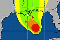
The map above is a probability swath for Katrina with the recently damaged Thunder Horse platform as the red dot, and the other purple dot represents the Mad Dog development that will ramp up to 100,000 bd; the Holstein development that will also produce, at peak, around 100,000 bd of oil; and the Atlantis field that will begin production next year and will ramp up to around 200,000 bd in all. Put together these projects have the potential of around 650,000 bd, but as can be seen, they are sitting in an uncomfortable spot relative to the track of the Katrina.
The white dot is where Port Fourchon is. This is where the Louisiana Offshore Oil Port, or LOOP, is located. Rigzone pointed out that this is where the foreign tankers offload, and as Joseph Palmer has linked to the Google and Terraserve maps you can see that the area is very low-lying. One of the big concerns is that there will be sub-sea landslides or other ground movement that might affect the LOOP. Were this to be disrupted, then foreign tankers would need to be diverted elsewhere, with the likely port being Houston.
Here is a link (from "Rod and Reel" no less) of the LA southern coastline showing Gulf rigs.
Update [2005-8-27 8:23:17 by Prof. Goose]:Here is a CBS MarketWatch article about Port Fourchon, a very important oil port, that says:
With the storm two days away from landfall, its course is still uncertain. The National Hurricane Center now expects the storm to make a second landfall near the major oil and gas hub at Port Fourchon, La., sometime Monday, and then continue inland to New Orleans. About one-sixth of the U.S. oil supply comes through the Port Fourchon facilities. The port, the only one in the region that handles supertankers, accounts for about 13% of U.S. oil imports. About 27% of U.S. domestic production comes through the port's pipelines. Even a minor disruption in production could send gasoline prices sharply higher.Update [2005-8-27 12:31:50 by Prof. Goose]:Here's a more comprehensive map of the fields on the south coast of LA and a graphic of the different types of platforms (hat tip: peakoil.com).
Update [2005-8-28 0:4:21 by Prof. Goose]:Here's a modeled map from NOLA done by LSU on the results of the hurricane if the forecast holds PDF WARNING
Update [2005-8-28 11:15:6 by Prof. Goose]:This link sadly, says it all, here's a snippet:
URGENT - WEATHER MESSAGE NATIONAL WEATHER SERVICE NEW ORLEANS LA 1011 AM CDT SUN AUG 28 2005 ..DEVASTATING DAMAGE EXPECTED HURRICANE KATRINA A MOST POWERFUL HURRICANE WITH UNPRECEDENTED STRENGTH...RIVALING THE INTENSITY OF HURRICANE CAMILLE OF 1969. MOST OF THE AREA WILL BE UNINHABITABLE FOR WEEKS...PERHAPS LONGER. AT LEAST ONE HALF OF WELL CONSTRUCTED HOMES WILL HAVE ROOF AND WALL FAILURE. ALL GABLED ROOFS WILL FAIL...LEAVING THOSE HOMES SEVERELY DAMAGED OR DESTROYED. THE MAJORITY OF INDUSTRIAL BUILDINGS WILL BECOME NON FUNCTIONAL. PARTIAL TO COMPLETE WALL AND ROOF FAILURE IS EXPECTED. ALL WOOD FRAMED LOW RISING APARTMENT BUILDINGS WILL BE DESTROYED. CONCRETE BLOCK LOW RISE APARTMENTS WILL SUSTAIN MAJOR DAMAGE...INCLUDING SOME WALL AND ROOF FAILURE. HIGH RISE OFFICE AND APARTMENT BUILDINGS WILL SWAY DANGEROUSLY...A FEW TO THE POINT OF TOTAL COLLAPSE. ALL WINDOWS WILL BLOW OUT. AIRBORNE DEBRIS WILL BE WIDESPREAD...AND MAY INCLUDE HEAVY ITEMS SUCH AS HOUSEHOLD APPLIANCES AND EVEN LIGHT VEHICLES. SPORT UTILITY VEHICLES AND LIGHT TRUCKS WILL BE MOVED. THE BLOWN DEBRIS WILL CREATE ADDITIONAL DESTRUCTION. PERSONS...PETS...AND LIVESTOCK EXPOSED TO THE WINDS WILL FACE CERTAIN DEATH IF STRUCK. POWER OUTAGES WILL LAST FOR WEEKS...AS MOST POWER POLES WILL BE DOWN AND TRANSFORMERS DESTROYED. WATER SHORTAGES WILL MAKE HUMAN SUFFERING INCREDIBLE BY MODERN STANDARDS. THE VAST MAJORITY OF NATIVE TREES WILL BE SNAPPED OR UPROOTED. ONLY THE HEARTIEST WILL REMAIN STANDING...BUT BE TOTALLY DEFOLIATED. FEW CROPS WILL REMAIN. LIVESTOCK LEFT EXPOSED TO THE WINDS WILL BE KILLED. AN INLAND HURRICANE WIND WARNING IS ISSUED WHEN SUSTAINED WINDS NEAR HURRICANE FORCE...OR FREQUENT GUSTS AT OR ABOVE HURRICANE FORCE...ARE CERTAIN WITHIN THE NEXT 12 TO 24 HOURS. ONCE TROPICAL STORM AND HURRICANE FORCE WINDS ONSET...DO NOT VENTURE OUTSIDE!
Update [2005-8-28 12:55:55 by Prof. Goose]:Here's a link to information about the Strategic Petroleum Reserve from the DoE.
In sum, this will be a very major event. Here's a link to current forecast maps, etc., for Katrina.
Update [2005-8-28 20:28:11 by Prof. Goose]:Don't forget to click back to the front page, we're updating above and in other posts now.
J said yesterday: The eastern GOM is already under evac, and central GOM due to follow suit shortly. If the storm follows the western Florida coastline, damage will be minimal or non-existent to everything except possibly the Mobile Bay deep gas wells. If you look at a map, you can see there is a large bay-like area between the "boot" of Louisiana and Mobile Bay. This is the Main Pass area, and it is home to a lot of oil production. Water depth in most of this area is less than 50 feet. The wellheads, caissons and platforms are numerous enough to swim from one to another most of the way to Mississippi. The more critical stuff (TLP's, FPSO's, Thunderhorse, etc) are clustered in the deep water offshore of the mouth of the Mississippi River. It will not take much change in direction to impact these structures. But as long as the storm is east of these areas, the worst will be avoided.
Technorati Tags: peak oil, oil, Katrina, Port Fourchon, weather, hurricane.
Contact
- Content: editors at theoildrum dot com
- Tech support: support at theoildrum dot com
License

This work is licensed under a Creative Commons Attribution-Share Alike 3.0 United States License.
http://www.nhc.noaa.gov/text/refresh/MIATCDAT2+shtml/270247.shtml
http://www.nhc.noaa.gov/index.shtml
This storm certainly has the potential to push crude over 70, perhaps much higher if and once damage is assessed. Friday's sellers will probably be piling back into the commodity once markets open again Sunday.
Other useful storm tracking sites:
Navy NRL Monterey Meteorology - better combined track map/graphic plus other visual, IR, etc sat shots and previous snapshot history:
http://www.nrlmry.navy.mil/tc_pages/tc_home.html
NOAA Satellite Services - the single and loop image links are quite intersting - check out the visible (daylight) and IR Ch. 4 loop view (at night).
http://www.ssd.noaa.gov/PS/TROP/trop-atl.html
http://www.gomr.mms.gov/index.html
I've got a very bad feeling about this....
Here are some overhead images:
Port Fourchon: (Google Maps)
Port Fourchon: (Terraserve)
I was a little surprised the move gained as much steam as it did, but I wasn't surprised to see a late Friday pm sell off following sideways price action and a big move up overall for the week. Both Natural Gas and Crude are effectively testing the top of contract highs; such tests are always points at which experienced traders go on high alert for signs of any reversal and this can cause sharp moves in either direction.
http://www.trendvue.com/charts/2005/08/tv20050826-25.gif
CL / NG intraday Friday
Its very common to see a late PM sell off (doesn't matter whether its oil or stocks or cotton or whatever) when price has acted strongly and then churned sideways. Longs with profits get more and more nervous as the chop continues - once the first dip out of the range failed to hold, a cascade of stops gets triggered.
Most of this price action is reflective of the moments in time then and there, not so much on big picture considerations.
What really surprised me was that so few stepped in to buy; common sense says the storm risk level at that point was higher than it is today, because risk was still largely unquantified. That far out, particularly since there wasn't any movement northward as yet, and the track still was pointing in the wrong direction, suggested to this trader that the track was still subject to significant revisions. Indeed the forecaster commentary supported this view too.
Therefore 45 minutes before the close on Friday was not the time to make firm decisions as to storm direction and risk.
Giving some traders the benefit of doubt, at the time the track and timeline suggested there would be an opportunity to buy back in before landfall, and the forecast seemed too far east to be a huge concern so some may have stood aside as a result believing they could add to positions on Sunday night in the electronic market or on London.
Given the current picture playing out, price is now more likely to gap up and leave em behind which may cause a little panic buying before the regular open of crude in London and then Nymex Monday am.
In the end I did some buying in the oil and gas sector (only companies with no GOM exposure) and added to my futures positions (short) in the broader market.
http://www.trendvue.com/charts/2005/08/tv20050827-01.gif
Its entirely possible I have some or all of these in the wrong place but in general I think starts to depict the risk to the areas these facilities are located.
Whether outages are power related or damage related it seems highly likely that there will be impact to supply that lasts at least as long as Ivan.
here's the link:
http://hurricane.methaz.org/hurapak/AAL122005_gomex_oil.html
those are amazing numbers that are modeled on Ivan and other hurricane behavior. experimental. scary.
57.3% of Gulf oil production is predicted to be cut for less than 10 days, 24% of oil production is predicted to be cut for 10-30 days.
That, folks, is a big deal if it's right.
http://hurricane.methaz.org/cgi-bin/mapserv.exe?mode=browse&zoom=1&layer=country&layer=o fcltrack&layer=damage&layer=sst&imgxy=299.5+299.5&imgext=-94.739423+23.670082+-84.93 3423+33.470082&map=..%2Fhurapak%2FAAL122005.map&savequery=true
http://hurricane.methaz.org/hurapak/AAL122005_gomex_oil.html
Projected 91% disruption of oil production if the weather models are correct, 68% for 10-30 days, 24% for over 30 days.
Wow. We're still 36 hours from landfall, but that is a daunting prospect.
Clearly if the track holds up as the models are increasingly agreeing on, there is certainly going to be at least the short term impact as reality; I wonder how early the first offshore damage assessments will be known... Tuesday / Wednesday? Next week is going to be terrifically volatile while the post storm impact is assessed.
Beyond production facilities I wonder how much refinery capacity is at risk.
http://hurricane.methaz.org/hurapak/AAL122005_staterep.html
To put that in context, if accurate, its the most expensive hurricane in history. I think this just tells us it could be big, really big, but also not to wig out until more info is available...
- Royal Dutch Shell plc (UK:RDSA: news, chart, profile) said Saturday it would shut its offshore operations, cutting production by 420,000 barrels of oil and 1.345 billion cubic feet of gas a day.
- The deepwater Louisiana Offshore Oil Port, 18 miles offshore, closed its offshore operations Saturday and said it would close onshore operations Sunday. The port is the only U.S. facility that handles supertankers.
http://www.marketwatch.com/news/story.asp?guid=%7BF7E49D16%2D0EF9%2D4D05%2D89DF%2D6020DC6793BE%7D&am p;siteid=mktwThe updates don't seem to be numbered, you have to look at the run start and end times at the right of the graphic. As I write this the run end time is 23:02:28, i.e. just after 11 PM Florida time, which is 30 minutes ago. The disruption percentages seem to have dropped somewhat from what was being quoted here earlier; instead of 91% being cut for up to 10 days, they are saying 77.8% now.
The thing I can't figure out is, in the table with the disruption percentages, the left column shows total oil production in barrels as approximately 12.9 million. What is the time period? The statistics I have seen indicate that the gulf produces about 1.5 million barrels per day. I can't come up with a plausible way to turn that rate into 12.9 million. It's like 8-9 days' worth, which doesn't make much sense.
And the natural gas is worse, it shows a production of about 121 million cubic feet, while actual production from the gulf is about 10 billion cu ft per day! So 121 million would be 17 minutes' worth of natgas production.
The rest of the table is consistent; for example the short term disruption of 77.8% shows a figure of 10.03 mbpd which is indeed 77.8% of 12.9 mbpd. I just can't figure out where these baseline production figures come from.
In a way it doesn't matter, what counts is the percentage reductions, but the fact that these numbers seem so absurd or even bogus makes me wonder if they just made them up for a test of the program, and casts doubt on its reliability or usefulness.
More on shut ins:
Katrina cuts oil output by a third
Sat Aug 27, 2005 8:37 PM ET16
HOUSTON (Reuters) - U.S. energy companies said U.S. Gulf of Mexico crude oil output was cut by more than one-third on Saturday as Hurricane Katrina appeared poised to charge through central production areas toward New Orleans.
As of Saturday, 563,000 barrels daily crude output had been shut in due to the threatening storm.
Shell Oil Co. (RDSa.L: Quote, Profile, Research), which was evacuating all 1,019 of its offshore workers in the central and eastern Gulf on Saturday, had the bulk of closed Gulf daily oil production, with 420,000 barrels turned off.
Shell also said 1.345 billion cubic feet per day, or Bfd, of natural gas had been shut by Saturday.
Total daily Gulf natural gas output shut on Saturday was 1.9 billion cubic feet.
Chalmette Refining LLC, which operates a New Orleans-area refinery, was shutting down production in preparation for the approach of the hurricane, which is predicted to produce winds near 131 mph (210 kph) when it charges ashore on Monday. Chalmette is a joint venture between Exxon Mobil Corp. (XOM.N: Quote, Profile, Research) and Venezuelan state oil company Petroleos de Venezuela SA and operates a 190,000-bpd refinery 9 miles east of downtown New Orleans.
http://asia.reuters.com/news/newsArticle.aspx?type=businessNews&storyID=2005-08-28T003656Z_01_N2 7143680_RTRIDST_0_BUSINESS-ENERGY-KATRINA-DC.XML
GOMEX short term numbers are probably as close to a sure thing as one can get on a bet by now.
Lets hope the N.O. nightmare scenarios don't come through, but something else will give. If the storm doesn't hook more to the north N.O. might be spared some but its going to likely be even worse for energy as the stronger leading edge will be more likely to run across all the major fields from LA west.
Damage estimate back up to all time record territory (31.56B at this writing)
http://hurricane.methaz.org/hurapak/AAL122005_staterep.html
By THE ASSOCIATED PRESS
Published: August 28, 2005 (Source: NY Times on the Web)
NEW ORLEANS -- Hurricane Katrina strengthened to a dangerous Category 5 on Sunday with 160 mph sustained wind as residents of south Louisiana jammed freeways in a rush to get out of the way of the powerful storm.
The National Hurricane Center put out a special advisory on the hurricane's gain in strength just before 8 a.m. EDT. The boost came just hours after Katrina reached Category 4, with wind of 145 mph, as it gathered energy from the warm water of the Gulf of Mexico.
Officials worried that not enough people were taking the monster Category 5 storm seriously enough.
"People need to take this very seriously and get to a safe area while they can," said State Police Sgt. Frank Coates.
Katrina was expected to hit the Gulf Coast early Monday and a hurricane warning was in effect from Morgan City to the Alabama-Florida line.
Visible Loop
Rick
I'm not so sure, the BBC has an article: Has oil production peaked? And yesterday at 3:15PM CNN did a story on Peak oil, including some stark sound bites by Matthew Simmons. The piece was called: "End Of Oil?".
The Peak Oil story is slowly soaking through the filters in to the mainstream press. The disruptions that we are sure to see from Katrina will keep it in the news. I'm just wondering what the markets will do when NYMEX opens for electronic trading at 19:00 EDT.
It is not clear to me whether the operators will trade up on the shortages of O&G or down on the shut in supply. That simulation at methaz.org is real nice, because it includes stats by operator including ST/MT/LT estimates.
My first guess is that drillers who have old jackups in the path of the storm will be most susciptible to declining share price, especially if they lose their rigs entirely. Operators who see a lot of production shut in for long term could see selling. Hard to handicap though. Watch BHP, Total and BP overnight in Australia and European markets.
http://www.rigzone.com/data/results.asp?sortField=0&sortDir=1&P=1&Rig_Name=&RWD_Max=-1&RWD_Min=-1&Region_ID=2&Rig_Type_ID=4&Manager_ID=-1&Rig_Status_ID=3&Operator_ID=-1
OLG will rise.
http://tinyurl.com/95e8m
That, fellas, is potentially a terrible economic shock--PETROLEUM ASIDE! Add an energy shock to the picture, and things look even more interesting.
So much for a seasonal retreat in gas prices after Labor Day.
In other words, they don't know, but it's the best they've got.
http://money.cnn.com/2005/08/28/news/economy/katrina_oil.reut/index.htm
Furthermore, it will be insteresting to see what this will do to the insurance industry. They have instituted coverage limits in Florida, what have they done on the Gulf Coast?
On the humanitarian side: after Katrina hits the sub sealevel city of New Orleans (if that indeed happens) the place may not look much better than the Indonesian coast did last December, though hopefully most residents will have escaped the city and be safe. As one who has traveled to India and other third world places -- I wonder if we are prepared for the kind of devastation that we Americans have been spared up till now. Perhaps we will see just how fortunate our country really has been.
Summary: hypothesis of a "worst case" scenario of the effects of Hurr. Kat. on the Port of New Orleans/So. La. (from which 15% of all U.S. exports pass- as measured by value)
The Geopolitics of Katrina
A Category 5 hurricane, the most severe type measured, Katrina has been reported heading directly toward the city of New Orleans. This would be a human catastrophe, since New Orleans sits in a bowl below sea level. However, Katrina is not only moving on New Orleans. It also is moving on the Port of Southern Louisiana. Were it to strike directly and furiously, Katrina would not only take a massive human toll, but also an enormous geopolitical one.
The Port of Southern Louisiana is the fifth-largest port in the world in terms of tonnage, and the largest port in the United States. The only global ports larger are Singapore, Rotterdam, Shanghai and Hong Kong. It is bigger than Houston, Chiba and Nagoya, Antwerp and New York/New Jersey. It is a key link in U.S. imports and exports and critical to the global economy.
The Port of Southern Louisiana stretches up and down the Mississippi River for about 50 miles, running north and south of New Orleans from St. James to St. Charles Parish. It is the key port for the export of grains to the rest of the world -- corn, soybeans, wheat and animal feed. Midwestern farmers and global consumers depend on those exports. The United States imports crude oil, petrochemicals, steel, fertilizers and ores through the port. Fifteen percent of all U.S. exports by value go through the port. Nearly half of the exports go to Europe.
The Port of Southern Louisiana is a river port. It depends on the navigability of the Mississippi River. The Mississippi is notorious for changing its course, and in southern Louisiana -- indeed along much of its length -- levees both protect the land from its water and maintain its course and navigability. Dredging and other maintenance are constant and necessary to maintain its navigability. It is fragile.
If New Orleans is hit, the Port of Southern Louisiana, by definition, also will be hit. No one can predict the precise course of the storm or its consequences. However, if we speculate on worse-case scenarios the following consequences jump out:
The port might become in whole or part unusable if levees burst. If the damage to the river and port facilities could not be repaired within 30 days when the U.S. harvests are at their peak, the effect on global agricultural prices could be substantial.
There is a large refinery at Belle Chasse. It is the only refinery that is seriously threatened by the storm, but if it were to be inundated, 250,000 barrels per day would go off line. Moreover, the threat of environmental danger would be substantial.
About 2 percent of world crude production and roughly 25 percent of U.S.-produced crude comes from the Gulf of Mexico and already is affected by Katrina. Platforms in the path of Katrina have been evacuated but others continue pumping. If this follows normal patterns, most production will be back on line within hours or days. However, if a Category 5 hurricane (of which there have only been three others in history) has a different effect, the damage could be longer lasting. Depending on the effect on the Port of Southern Louisiana, the ability to ship could be affected.
A narrow, two-lane highway that handles approximately 10,000 vehicles a day, is used for transport of cargo and petroleum products and provides port access for thousands of employees is threatened with closure. A closure of as long as two weeks could rapidly push gasoline prices higher.
At a time when oil prices are in the mid-60-dollar range and starting to hurt, the hurricane has an obvious effect. However, it must be borne in mind that the Mississippi remains a key American shipping route, particularly for the export and import of a variety of primary commodities from grain to oil, as well as steel and rubber. Andrew Jackson fought hard to keep the British from taking New Orleans because he knew it was the main artery for U.S. trade with the world. He was right and its role has not changed since then.
This is not a prediction. We do not know the path of the storm and we cannot predict its effects. It is a warning that if a Category 5 hurricane hits the Port of Southern Louisiana and causes the damage that is merely at the outer reach of the probable, the effect on the global system will be substantial.