Hurricane Katrina and Thunder Horse/Gulf Oil Production (Kat now potentially a Cat 4?)
Posted by Prof. Goose on August 26, 2005 - 11:24am

Update [2005-8-27 0:15:36 by Prof. Goose]:This information is somewhat dated, look to the post above this for the most current information.
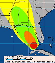
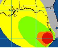
[editor's note, by Prof. Goose]This is a modified repost of an article HO did on 9 JUL about Dennis and Gulf oil production, (and then here's a story of what happened to Thunder Horse), so we could get a map up of oil platforms in relation to Katrina's whereabouts...her path looks to be slightly east of Dennis' (Dennis' path is the first pic...(The black dot on the edge of the green and yellow zones south of New Orleans, in the first map represents the Thunder Horse platform which is scheduled to ramp up until it is producing 250,000 bd of oil at a water depth of about 6,000 ft.), Katrina's probability swath is the second picture, Katrina's current models are the third, TH listing is the fourth) at this time, but it's early days on path prediction as you can see from the pic.
HO may get to post something on these developments today, but I wanted to get this information up.
Update [2005-8-26 11:16:36 by Prof. Goose]:Weather porn for you from the latest advisory (found at noaa.gov via peakoil.com):
GIVEN THE RAPID IMPROVEMENT IN THE INNER CORE STRUCTURE AND THE SHARP PRESSURE DROP...RAPID INTENSIFICATION SEEMS LIKELY FOR THE NEXT 12 HOURS OR SO. AFTERWARDS...STEADY INTENSIFICATION TO NEAR CATEGORY FOUR STRENGTH BY 72 HOURS APPEARS TO BE IN ORDER GIVEN THE VERY WARM GULF WATERS BENEATH THE HURRICANE AND THE VERTICAL SHEAR FORECAST TO DECREASE TO LESS THAN 10 KT BY 48 HOURS.
The black dot on the edge of the green and yellow zones south of New Orleans, represents the Thunder Horse platform which is scheduled to ramp up until it is producing 250,000 bd of oil at a water depth of about 6,000 ft.
The white dot further out and in the blue zone nearer the left side, represents the Mad Dog development that will ramp up to 100,000 bd; the Holsteindevelopment that will also produce, at peak, around 100,000 bd of oil; and the Atlantis field that will begin production next year and will ramp up to around 200,000 bd in all.
Put together these projects have the potential of around 650,000 bd, but as can be seen, they are sitting in an uncomfortable spot relative to the tracks of the hurricanes.
And with the hurricane season showing the promise of being worse than usual, this has the potential not just to threaten completion of these projects, but also in the years to come posing some threat to their continued ability to reach the target levels required in the times of the year that will be most critical (from now through the end of the year). As J has pointed out before, there is only a certain amount of repair capacity available, and if the storms keep coming, this will diminish overall the supply that we will increasingly need.
Technorati Tags: peak oil, oil, Katrina, Thunder Horse.
Hurricane Katrina and Thunder Horse/Gulf Oil Production (Kat now potentially a Cat 4?)
PDF version
12 comments
Hurricane Katrina and Thunder Horse/Gulf Oil Production (Kat now potentially a Cat 4?)
PDF version
12 comments
Contact
- Content: editors at theoildrum dot com
- Tech support: support at theoildrum dot com
License

This work is licensed under a Creative Commons Attribution-Share Alike 3.0 United States License.
If we're going to drill for oil in 10,000 feet of water, there are plenty of risks. Hurricanes are just one of the many.
Isn't Katrina the eight named storm to pass through the gulf this season? And it's not even September yet!
the hermit
I think Thunder Horse was close to the limit where the flip starts. These semi TLP's flip upside down once ballast get past a certain point. Google Ocean Ranger.
Regardless... the track is now far more westward than earlier this am....
http://www.nhc.noaa.gov/refresh/graphics_at2+shtml/204201.shtml?5day
http://www.nrlmry.navy.mil/tc_pages/tc_home.html
The more critical stuff (TLP's, FPSO's, Thunderhorse, etc) are clustered in the deep water offshore of the mouth of the Mississippi River. It will not take much change in direction to impact these structures. But as long as the storm is east of these areas, the worst will be avoided.
Futures markets had soft support today - the sell off I'm convinced was low-conviction, low-volume driven into a Friday and at a time when computer models had Katrina well to the west. Amateur weather forecasters all of us now.
I'm fairly certain that any selling would have been better contained if traders saw tracks trending to the west of Mobil. I'm also surprised that traders were willing to make bets based on models before the turn had actually started... not a move I would, or did, make.
After all, Ivan 2004 was the third most costly hurricane ever to hit the US and its leading edge hit Alabama/Florida; if current trends persist, the leading edge will be much closer to important stuff than last years storm.
By the time crude re-opens in London and here in two days there should be a much better idea of track and thus risk.
Just watch where Jim Cantore is broadcasting from on Saturday night / Sunday morning. That should tell you who's about to get slammed :)
The model now shows the total destruction of New Orleans, but I'm not sure I believe it.
Soon it won't matter. A little farther east and N.O. will get the full fury of the leading edge (east front of the storm), a little farther west and virtually all of the big GOM production areas will get hurricane cat 5 winds.
Perhaps sea conditions or other factors might mitigate damage and make this less than it appears now, but from an oil perspective only we can assume it will be as bad as Ivan and then some.
Weather bulletin linked elsewhere here reads like the plot of a B-movie:
http://kamala.cod.edu/offs/KLIX/0508281550.wwus74.html