More Tools for Rita
Posted by Prof. Goose on September 19, 2005 - 11:36pm
(welcome MSNBC viewers...while there's some interesting stuff in this post, but I think they might have linked to the wrong one from the description...click here to go the article I think they meant to send you to, or click here to go out to the front page. Either way, welcome!)
Here is a listing of oil related facilities in LA and TX
Here is a picture of the models superimposed with the gas/oil rigs and Katrina's path (thanks billyt): 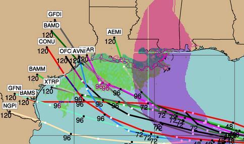
Technorati Tags: peak oil, oil, Rita, Hurricane Rita, gas prices
“He that will not apply new remedies must expect new evils, for time is the greatest innovator.”
—Francis Bacon, Essays
Contact
- Content: editors at theoildrum dot com
- Tech support: support at theoildrum dot com
License

This work is licensed under a Creative Commons Attribution-Share Alike 3.0 United States License.
I don't think we need to look for divine causes to explain disasters which we know occur quite periodically. Atlantic hurricane activity is cyclical. Climatologists have known this upsurge was coming. If you build in or near the coast (Gulf or southern Atlantic) you have to either build for a Cat-5 or don't blame God when you get blown away.
No retribution here. No divine message. At least not from any god that I would respect. Just poor planning and cost-cutting where it can do a lot of damage.
I happen to have some exquisite pictures taken from official radars tracking Ophelia showing a neat 60 degree sided triangle, where the eye would be, said triangle showing up on visible scale and rain fall. That Ophelia was triple looping around the ocean, is, again, nothing out of the ordinary, right?
You might need a hint to organise and focus your pattern of thinking: look up what former Def Sec Cohen said about weapons that could trigger earthquakes, hurricanes and such like. Also, I paraphrase Bush's visit to NO: "It looks like the coast was it with the worst sort of weapon there is."
You do remember then, when the US invaded Iraq, a major dust storm appeared just when the invasion was in full swing?
Now, two hurricanes heading into oil producing regions and big cities, back-to-back, is what? A coincidence?
http://www.mms.gov/ooc/press/2005/press0920.htm
These evacuations are equivalent to 16.61% of 819 manned platforms and 11.19% of 134 rigs currently operating in the Gulf of Mexico (GOM).
Today's shut-in oil production is 877,275 BOPD. This shut-in oil production is equivalent to 58.49% of the daily oil production in the GOM, which is currently approximately 1.5 million BOPD. Approximately 35% of shut-in oil is due to onshore infrastructure problems.
Today's shut-in gas production is 3.482BCFPD. This shut-in gas production is equivalent to 34.82% of the daily gas production in the GOM, which is currently approximately 10 BCFPD.
The cumulative shut-in oil production for the period 8/26/05-9/20/05 is 26,000,491 bbls, which is equivalent to 4.749 % of the yearly production of oil in the GOM (approximately 547.5 million barrels).
The cumulative shut-in gas production 8/26/05-9/20/05 is 120.413 BCF, which is equivalent to 3.299% of the yearly production of gas in the GOM (approximately 3.65 TCF).
It doesn't take much to seriously flood here. We're between 0 and 3 feet above sea level on average. However some of the highways, feeder roads, the tunnel system downtown, and certain residential areas range from below sea level to far below sea level. There are bayous to help drain, but they are no match for serious rain.
Downtown and the highways are highly vulnerable to partial or nearly complete blockage. I was out when tropical storm Allison hit... and I never want to go through a similar experience again.
Oh the irony of life.... sigh
Allison didn't hit Houston directly. They did a study of it after it hit and determined that if it had hit us directly, the entire city would've been under water. Sort of like what happened with NOLA. What made Allison bad, as tropical storms go, was that it stalled out over the city due to a high pressure system or something of that nature.
I didn't realize it was going to hit, at least not with that ferocity. I was about to go into a club and it started pouring. We waited for it to let up and it didn't. So we got soaked running in. A few minutes later we decided to leave... and there were nearly 2 feet of water in some areas... it was insane. I never want to experience that again.
I get the odd feeling that the bean counters at the big oil companies are drowning under the influx of cash just as the laundryman drowns under the influx of clothes in a multi storey apartment..
Remember Deffyee's story about that day in 1971 when the Texas Railroad Commission lifted caps on Texas oil production? He went home and told his wife, "That old fool, Hubbert was right after all". It was Peak Day USA.
Well this 9/19/2005 story in Washington Post seems similar:
http://www.washingtonpost.com/wp-dyn/content/article/2005/09/18/AR2005091801010.html
Is this Peak Day OPEC/World?
(Damn, we did not make it even to Thanksgiving 2005.)
I agree it's an important milestone. I can't recall who said it, but the quote was:"The good news is that OPEC doesn't control prices anymore. The bad news is that nobody does."
Like a drug dealer "I'm just trying to give you a hand"
Bloomberg story on oil dropping from highs
But to quote every weather forecaster I've read today:
"It's still way too early to know."
According to this Morning Edition story from NPR What If Another Hurricane Hits New Orleans?, meteorologist David Nolan of the University of Miami says that Katrina's passage through the Gulf actually lowered sea surface temperatures there. The reason is that Katrina's winds contributed to better mixing of Gulf waters resulting in more upwelling of colder water. If true, this will diminish Rita's ability to gain strength as it passes over the region.
On the other hand, there is this seemingly contradictory information from NHC forecaster AvilaIt's hard to know what to believe about this Category 1 storm.
I'm not sure what their definition of "cooled" is, but if Katrina made a difference, I guess that's a good thing. As always, in another day or two things will become much more clear.
It seems they have revised the paths some, just wondering what the new map looks like.
Educated guesses and all that...
http://euler.atmos.colostate.edu/~vigh/guidance/atlantic/early1.png
(this will also be at the bottom of the newest post)