When the Hurricanes Come
Posted by Stuart Staniford on June 10, 2006 - 1:36pm
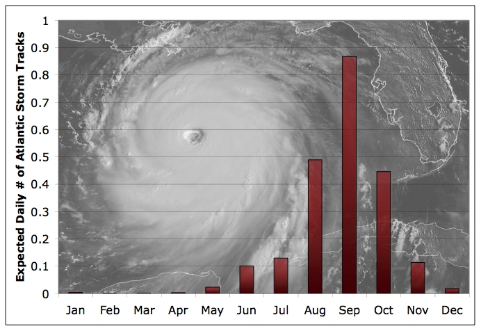
Average number of storm tracks (any category) on a given day in each month over the period 1851-2005. Source: NOAA NHC.
Update [2006-6-10 13:36:2 by Stuart Staniford]: Well, what do you know - here's Tropical Depression One:
Update [2006-6-11 18:12:55 by Stuart Staniford]: Now Tropical Storm Alberto.

Projected three day track of tropical depression ONE. Source: NOAA NHC.
Update [2006-6-12 12:48:38 by Stuart Staniford]: "ALBERTO HAS THE POTENTIAL TO BECOME A HURRICANE WITHIN THE NEXT 24 HOURS."
Checking in with SSTs, the big temperature anomaly in the Gulf a month or two ago seems to have mostly dissipated:
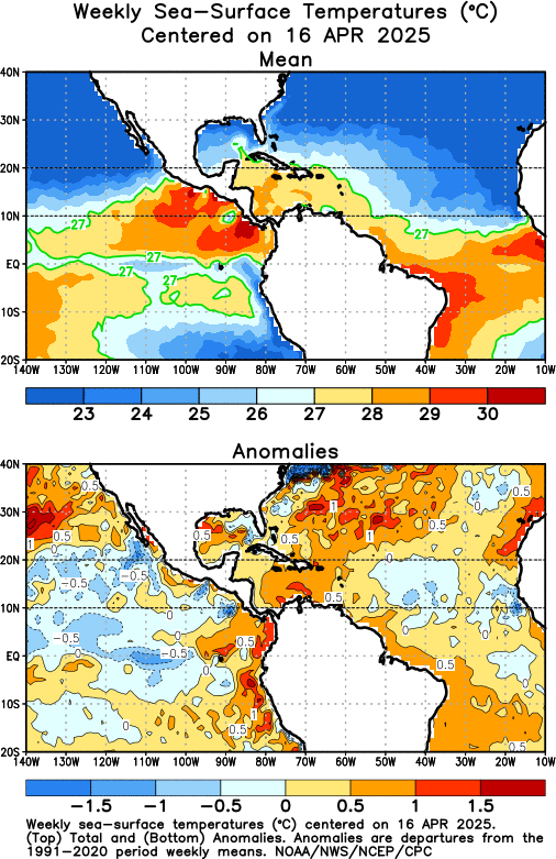
SSTs in the tropical Atlantic, together with anomaly from average. Source: NOAA.
However, it's still warm all across the tropical Atlantic.
Finally, I can't resist reposting this graph I put in a comment on HO's thread:
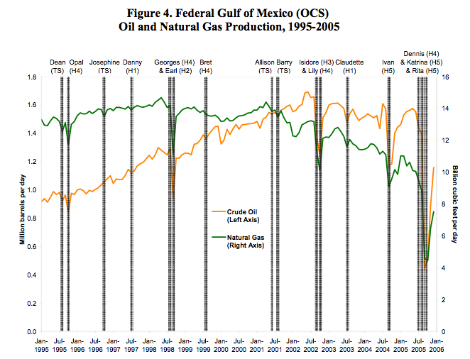
Oil and NG production in the Gulf of Mexico, together with hurricanes and tropical storms in the region. Source: EIA.
Contact
- Content: editors at theoildrum dot com
- Tech support: support at theoildrum dot com
License

This work is licensed under a Creative Commons Attribution-Share Alike 3.0 United States License.
Plus, it's funny to see Anderson Cooper getting blown to hell and gone.
Uhh....Accuweather.com says that a tropical storm just might form in the the next few days:
http://hurricane.accuweather.com/hurricane/regions.asp?partner=accuweather&site=ATL
Brief excerpt:
------------
Today's Discussion
Low pressure in the Northwest Caribbean is Starting to Organize
Posted: 8-JUN-2006 2:57pm EDT
By Expert Senior Meteorologist Dan Kottlowski
A broad area of low pressure that we have been watching and speculating on since Monday is showing some signs of organization. Ship reports and buoys in this area are showing pressure falls. At one point a ship was reporting a pressure down to 1005 millibars just off the coast of Belize.
------------
Bob Shaw in Phx,AZ Are Humans Smarter than Yeast?
The Unisys site is a good one for weather weenies. Only the coverage outside the US proper (eg wind shear over Caribbean) and SST coverage are weak.
Re: hurricanes in June. That's one reason last year was so unusual.
Winds up to 70 MPH. Going to be a hurricane. Warnings up for west coast.
The GOM must have plenty of energy for this to blow up this early in the season.
In Item 695 (April Newsletter) covering world discovery rates we referred to the deepwater well Noxal-1 off Mexico expressing some doubt that the reserves of 10 Gb reported by the press on the basis of government releases were valid. We are now informed by an engineer with detailed knowledge of the project that in fact the well failed to make a significant discovery. It is possible that the 10 Gb estimate mentioned by government officials referred to the expected reserves of the entire deepwater area of Mexico, which would not be unreasonable, but was mistakenly attributed to this particular borehole.
----ASPO
Shows measurements a touch higher than the monthly norms.
Redneck Kockey on Tobacco Road.
There are trees still down in my yard at the edge of my property from the 90 mph gusts and the constant hurricane force winds that made my attic hum like an organ pipe.
Hurricanes in June...please, no. It's too damned early.
http://hurricanehoopla.com/
www.dltk-kids.com/type/felt_board.htm
http://www.weather.com/newscenter/tropical/?from=wxcenter_news
I filled out my brackets yesterday!
http://hurricanehoopla.com/why.htm
Why Are We Doing This?
Why are we doing this? Because for too long Main Stream Media has enjoyed a monopoly on the inflated excitement surrounding our annual hurricane season. Why should they get to have all the fun? We want to help whip Americans into a feverish frenzy concerning the coming storms. We'd like to help with up to the nanosecond
coverage of the slightest change in the direction or intensity of approaching tempests. We wish to stir up as much anxiety as the American public can handle with headlines that strike fear into the hearts of those who can't bear to look away!!!
Then, before the last drops of rain have fallen, we'll quickly lose interest and move on to the next disastrous, newsworthy event. Like the Drive-by Media we won't bother to adequately discuss the connections between weather, our energy supply and the further implications to our economy. We just want to help put more silly weatherpeople in hazardous locations where a stationary camera would work just fine.
No, wait... maybe we could use an amusing and irreverent stick to poke fun at our national obsession with disaster. We could also use this voice to educate Americans about how weather and energy affect their everyday lives in ways they probably couldn't imagine. Perhaps we could use this tongue-in-cheek form of Weather Sport to not only get some attention `round the office water cooler but also as a tool to help us as a nation better understand the natural forces to whom we are beholden. Perhaps we could make fun of those that scream about the storms and try and to do a little good while we're at it. Yeah, that's it. That's why we're doing this.
Check back as our educational resources sprout and grow.
That puts things in a very different perspective. It's basically poking fun at our national past time of disaster obsession. It also pokes fun at FEMA:
Please come back soon! This site is rebuilding due to the devastating effects of hurricanes Katrina and Rita. We'll add plenty more bells and whistles as soon as we get our fema check.
http://www.srh.noaa.gov/tlh/tropical/index.html
http://weather.unisys.com/hurricane/atlantic/1945/index.html
http://weather.unisys.com/hurricane/atlantic/1951/index.html
http://weather.unisys.com/hurricane/atlantic/1957/index.html
http://weather.unisys.com/hurricane/atlantic/1966/index.html