Cyclone Gonu Thread 3 (Last Updated 10pm EDT, 6/6)
Posted by Prof. Goose on June 6, 2007 - 3:00am
New thread for Cyclone Gonu as of noon EDT, 6/7 can be found here...please put new material in the comment thread there.
Exclusive--Please credit The Oil Drum and Chuck Watson of KAC/UCF. KAC/UCF and Chuck Watson are forecasting, based on their damage models, that the Qalhat (Sur) LNG terminal will be out for 20-30 days and the Mina al Fahal oil terminal will be down for 10-20 days--all of this assuming they are built to US standards. (NB: These damage estimates have decreased a bit since the last model run...and assume US construction standards.)
All tips and resources (*and there are already many down there in earlier threads, let's replicate that here today in the third thread! Thank you!*) welcome in the comment thread below. If you have any insights, please email the editors box with the word GONU in the subject.
Last updated at 10pm EDT, 6/6. This still could be an important event--but we are in a slow news time right now regarding Oman and the area. If you have any insights, please let us know--email us or put them in the comment thread. We're digging on this too...
Here are links to our first Cyclone Gonu Thread (6/4) and our second thread on the same topic (6/5).
Please put all new resources and insights here as of 1am EDT 6/6, but make sure to check out the first two threads as well.
Why might Cyclone Gonu matter? Well, that answer begins with the fact that the world production of petroleum plateauing around 85 mbbl/day, so any slight blip in supply or exporting could be quite noticeable on the world markets--as a sizeable portion of the world's petroleum exports go through the Gulf of Oman.
Particularly, Oman also matters in this because it produces 743,000 bbl/day; Oman is also a net exporter, non-OPEC, whose production peaked earlier in the decade.
Of course, this storm also has the potential to affect petroleum exports from Iran and the UAE for that matter--mainly because of shipping disruptions in the Straits of Hormuz, but there could also be some real effects on infrastructure and assets depending on storm surge, track and landfall. There are also refining and other production assets in Southern Iran that could be affected depending on the strength of Gonu.
Also, click "there's more" below for more graphics, forecasts, and links, and there's much more from our readers in the comment thread as well...
Resources:
The latest from Margie Kieper at Weather Underground:
Gonu evaporated, essentially, today, while traversing the Gulf of Oman. Clouds over the center dissipated, and convection thinned and dispersed outward. It appears that damage was severe along the extreme southeastern coast that I talked about on Jeff's blog Tuesday. Roads to the area have been washed out, and now that winds have subsided, helicopters will be able to access the area. It will be morning shortly in Oman, and likely this will bring the first news of what has happened in these areas. [...] The TRMM product indicated that about 175mm of rain fell in Mascat the last 24 hours.
This is an unprecedented event. NO CYCLONE has ever entered the Gulf of Oman. And there are no custom 'storm surge' models available for that area. This forecast is based on my experience and subjective analysis of the seabed slope and storm surge interaction with the sea floor. Considering the region has never experienced a hurricane, let alone a strong one it is highly unlikely the loading facilities or platforms were constructed to withstand the forces - both wave action and wind force - that they will experience. Significant, damage will occur. How much long term damage, and the volumes associated with it - can not be determined at this time.
And here's the latest projected track:

As for damage assessments, a tip of the hat to Kinetic Analysis Corporation (affiliated with the University of Central Florida). Early estimates of damage and tracking are available here (Scroll down to Gonu). Here's a graphic:

KAC/UCF has also been kind enough to send us some graphics of the storm surge model with the current forecast:


Here's a link to a map of land-based oil assets on the peninsula.
Regarding GONU...
http://news.google.com/news?hl=en&ned=&q=gonu
Sorted by date...
http://news.google.com/news?hl=en&ned=&q=gonu&ie=UTF-8&scoring=n
![]()
http://wwwa.accuweather.com/news-blogs.asp?blog=andrews&date=2007-06-04_...
--I can say with confidence that this forecaster has never seen the likes of this
If you go here, and click
on the North Indian Ocean links, you can get a feel for how rare this is. From 1995 on, no tropical storm of any strength ever reached the Persian Gulf.

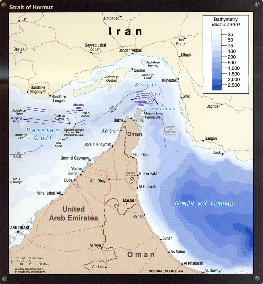
http://www.lib.utexas.edu/maps/middle_east_and_asia/iran_strait_of_hormu...
(from Stuart: There's past year storm tracks at The University of Hawaii (click on the North Indian years). Here's the most active past year I could find (1998):

http://www.eia.doe.gov/emeu/cabs/Iran/Background.html
Here's a map of the area:


Contact
- Content: editors at theoildrum dot com
- Tech support: support at theoildrum dot com
License

This work is licensed under a Creative Commons Attribution-Share Alike 3.0 United States License.
Here in SoCal, a couple inches of rain in the San Bernardino mountains will trigger mudslides that wreak of havoc on the cities of San Bernardino and Highland. I believe we have much more vegetation than the mountains of eastern Oman. I can't imagine what is going on over there right now...
Some information on Qalhat LNG near Sur which I overlooked yesterday (this thing will get hit badly). Appears that LNG from there is going mainly to Japan.
"Japanse companies will purchase a total of 23 mtpy of LNG from state-owned Qalhat LNG (SAOC): 700,000 tpy to Itochu Corp. for 20 years starting in 2006, 800,000 tpy to Osaka Gas Co. Ltd. for 17 years from 2009, and 800,000 tpy to Mitsubishi Corp. for 15 years, possibly extending to 20 years."
"The sultanate was expanding its LNG carrier fleet to transport increased production from Oman LNG's projeced third train at its Qalhat liquefaction terminal near Sur on the northeastern coast. Oman's total LNG production was 7.009 bcm (274.5 bcf) in April, up from 6.338 bcm (223.8 bcf) in 2003. Oman will charter a 138,000 cu m LNG carrier to join Sohar and Muscat, the other two carriers in the government's fleet"
Information is from the 2005 World Petroleum Encyclopedia.
I just did a quick search of Japanese news sources for Oman and Typhoon.
Nothing.
Does this mean I'm taking cold showers this winter?
No, Japan imports lots of LNG, this will mean that prices will likely be higher temporarily. Since the port doesn't ship that much LNG it won't have a large impact.
I just found this
Looks like we get only a tiny bit of our gas from Oman. So no big deal to Japan.
It is interesting to note that Japan is by far (58%) the largest importer of LNG in the world at.
Rembrandt -- Your news source cites 2.3mt/y (23 in the quote, but the subtotals add to 2.3) from the Qualhat LNG plant; this represents about 5% of Japanese demand, if I recall correctly.
BTW, this is the setting for the plant:
!
Found it in google earth
http://maps.google.com/maps?f=q&hl=en&q=Qalhat,+Oman&sll=37.0625,-95.677...
Hello Rethin,
Not sure who is correct, but your overhead view and BostonGeologist's photo sure are different.
totoneila,
They are both the same picture; my view just cuts off the southern facility and looks to the southwest. No funny business :)
Hello BostonGeologist & Rethin,
Yep--you are right--once I zoomed out on Rethin's overhead. My apologies to both.
Hello BostonGeologist,
Hell, from the picture: it looks like the whole damn thing is located in a floodplain. Does that mean it is getting hammered on Both Sides from hurricane surge and flashfloods? I bet the Insurance Company is freaking about now!
Bob Shaw in Phx,Az Are Humans Smarter than Yeast?
Not just a flood plain, it looks like an alluvial wash. It is hard to imagine how it will look like once all the water recedes.
"This facility was build to the HIGHEST standards! There is nothing that can destroy it! Praise Allah!"
Ibn Gamblin Al Day
President, Qualhat Construction Corp.
Room #777
Casino Grande, Macao
(no calls please)
All of my hot water heaters (the small wall units) when I lived in Japan used propane gas (well, LPG which I assumed was usually propane). Are you sure your hot water heater uses NG/methane?
Nevertheless, this event demonstrates again how vulnerable Japan is, given that it imports nearly all of its energy sources, with a great share coming from the ME. Anything that happens in the ME thus is of interest to the Japanese, which explains why during Abe's recent tour of that area he was accompanied by a small army of Japanese corp. executives, a first.
I'm pretty sure its LNG. I'll have to check my gas bill when I get home now.
But I see a lot of houses with LPG cylinders outside them as well.
Could someone repost the map that shows where the LNG and Crude oil export terminals are. From the Bloomberg artical mentioned below, Mina Al Fihal seems to pump all of Oman's oil. Seems significant if it is out for 20 days.
Here's the Omani electrical infrastucture from earlier:
Efforting the other one. Where did it go?
Google maps?
MINA AL FAHL
http://maps.google.com/maps?f=q&hl=en&q=23.65,+58.5&ie=UTF8&t=h&om=1&ll=...
QALHAT
http://maps.google.com/maps?f=q&hl=en&q=22.68,+59.4&ie=UTF8&t=h&om=1&ll=...
I would think that the reality of situations such as this in an energy system with little or no slack for shortages would be a wake up call for immediate worldwide Peak Oil preparations.
Oil = money = power. Are we willing to go over the brink before governments start preparing their citizens to live in a world with much less than what they have been accustomed to?
Could this storm be the catalyst that makes the global community have that hard family talk everyone has been avoiding?
That further energy growth with the existing infrastructure is not possible?
www.lawnstogardens.com
New thread on Gonu as of Noon EDT, 6/7.
http://www.theoildrum.com/node/2639
please put all new material and insight there.
Check here for pictures of what Cyclone George did to the north-west of Western Australia 2 months ago- see the bottom pictures of mining camp huts (designed to withstand such winds) absolutely smashed:
http://www.abc.net.au/northwestwa/stories/s1868490.htm
Cross your fingers for oil workers in Oman and Iran.
This rainfall forecast map for THURSDAY from BBC world weather shows a relatively small area of heavy rainfall to the NE of the Oman mountains, centred on the Gulf of Oman. This area is to the N and E of main Omani oil and gas infrastructure (I think). The main hazzard IMO will be from flash flooding in wadis - that can appear hundreds of miles away from where the rain falls.
http://www.bbc.co.uk/weather/world/middle_east/rain.shtml#no_url
This link to the UK MET office world weather allows you to run a short time lapse sequence - showing Gonu in the Gulf of Oman.
http://www.metoffice.gov.uk/satpics/africa_IR.html
And the latest weather from Musat International Airport from Wunderground:
77 °F / 25 °C
Light Rain
Humidity: 96%
Dew Point: 76 °F / 24 °C
Wind: 20 mph / 32 km/h / from the North
Wind Gust: -
Pressure: 29.48 in / 998 hPa
Visibility: 1.0 miles / 1.0 kilometers
UV: 3 out of 16
Clouds: Scattered Clouds 787 ft / 240 m
Mostly Cloudy 2461 ft / 750 m
Few 2953 ft / 900 m
Overcast 7874 ft / 2400 m
(Above Ground Level)
http://www.wunderground.com/global/stations/41256.html
Light rain and 20 mph winds (gusting 30 mph).
73 °F / 23 °C
Heavy Thunderstorms and Rain
Humidity: 100%
Dew Point: 73 °F / 23 °C
Wind: 30 mph / 48 km/h / from the West
Wind Gust: -
Pressure: 29.34 in / 993 hPa
Visibility: 2.0 miles / 3.0 kilometers
UV: 1 out of 16
Clouds: Scattered Clouds 787 ft / 240 m
Mostly Cloudy 2461 ft / 750 m
Few 2953 ft / 900 m
Overcast 7874 ft / 2400 m
(Above Ground Level)
Heavy thuderstorms and 30 mph winds - time to pack away the windsurfer
Note wind from the west suggesting the storm centre is likely to be due north. Also 100% humidity.
Point your left arm directly into the wind and extend your right arm at 90 degrees or right angle and the right arm is pointing at the storm center. Old sailors never forget. In the northern Lat. For southern Lat use the right arm for wind.
Thursday morning
Seeb, International Airport, Oman
Elevation: 26 ft / 8 m
85 °F / 29 °C
Partly Cloudy
Humidity: 52%
Dew Point: 70 °F / 21 °C
Wind: 25 mph / 41 km/h / from the West
Wind Gust: -
Pressure: 29.54 in / 1000 hPa
Visibility: 6.0 miles / 10.0 kilometers
Clouds: Few 1181 ft / 360 m
Scattered Clouds 2461 ft / 750 m
Mostly Cloudy 9843 ft / 3000 m
(Above Ground Level)
Partly cloudy, wind 25 mph - it looks like Gonu has moved on
Some may be interested to know that Cyclonic storms are not uncommon in Oman. Kyle circulated a report on Omani flood preparations that mentioned earlier cyclones in 2002, 1996, 1983, 1977, 1966, 1963, 1959 and 1948.
Following up on my flooding comments in Gonu thread #2, a quote from the wunderground forum:
"still have power in qurum. wind speed continues to pick up - say F5. hear that road through wadi adai (major road out of muscat to quriyat - 90kms SE muscat) has been washed away in 2 locations. that road was only re-constructed 4 years ago and as afar as i can recall culverts and bridges were designed on basis of 50-year storm return period. but remains to be seen whether reports are true"
If reports are true, and they're exceeding 50-year flow in multiple locations this early in the storm curve, it's not good.
I finally found some good material to help evalutate the flood potential:
Hydrology of Wadi Systems: Chapters 1 & 2
Chapter 3
Chapter 4
Chapter 5
Still looking for the later chapters, but items of note from the material above:
-Available rainfall records on the Arabian peninsula reflect only spotty heavy rains; there aren't any large-area, heavy rainfall events examined, so the current event lies outside of the understanding of Oman hydrology
-It takes at least 10hrs of full flow to saturate the banks of wabis in some study areas; before this time a significant amount of the flow transmits below the surface
-Northern Oman has a large alluvial aquifer system which is used heavily for drinking water. An exceptional event like this will be a significant recharge event for that aquifer; this will likely delay the heaviest flow in wabis overlying deep alluvium.
A bit more about the coastal geology/geography; this is all going off what I can see in Google Earth / panoramia, so take w/ a grain of salt, but what I can see is three types of coastline:
Fjordlike/rugged, where the coastal range is innundated and there's no exposure of the continental shelf and no modern alluvial deposits:
Bandar Khairan
Continental shelf exposed w/ modern overburden; these areas are carbonate/limestone bedrock (I assume formed recently in the present gulf of oman) overlaid by pretty classic high-energy alluvium:
Sinkhole in Oman; 5km ssw of Dibab
I love that photo... you can very clearly see the limestone/shallow sea deposits making up most of the wall of the sinkhole, and then the very poorly sorted (wide range of particle size) fluvial (river) deposits lying on top, forming the top several meters of the subsurface. If you look closely, you can see that the larger rocks/boulders in the fluvial deposits are less rounded than the smaller rocks, indicating that they spent little time in the paleo wadi channel upstream and likely made most of their journey from outcropping to coastal plain in just a few flood events.
Anyway, to see the larger setting of this sort of coast:
Dibab, Oman
You can see that the mountains come to a smooth, sharp drop, and that the land sticking out from there extends a distance from the mountains uncorrelated with modern wabi/river paths. This is the outline of the part of the former seabed that has been lifted (or exposed by dropping sealevel). If you look closely, you can see the pattern of modern alluvium deposited on this shelf by later river action.
Lastly is active delta/fluvial dominated coast. Now, in these seas it doesn't take much to be fluvialy dominated (the wave/wind action is normally very subdued, and there's almost no tidal action to speak of), so even a wabi's intermittant flow can maintain an active delta:
Delta in NE Oman
Each of these three coastal types will exhibit a very different response to rainfall, surge, and wave... due to differences in coastal steepness, offshore landform, infiltration, existing drainage pattern, and wave action damping capacity. The modern active deltas are the lowest lying land, but have some vegetation and a greater area of existing drainage channels. The limestone platforms have generally higher land, but smaller channel capacity and reduced infiltration capacity. The rugged coastline rises quickly enough to avoid most surge/wave danger, and offers well-contained drainage, but is largely unpopulated.
This is one of the reasons I love this site - there's such breadth and depth of knowledge. Small point here: the last two links (Dibab, delta) both point to the Dibab image.
The "Sleepless in Muscat" Blog has been updated this morning:
http://sleeplessinmuscat.blogspot.com/
rainsong posted a great real time(ish) GIF yesterday:
http://cimss.ssec.wisc.edu/tropic/real-time/indian/storm/dvor-nh02A.GIF
anyone know how to post this?
Found this one:
http://www.rttnews.com/FOREX/gblnews.asp?date=06/06/2007&item=8
Shipping was yet continuing through the strait yesterday according to this report. The national holiday until Saturday might keep Oman's oil & LNG loading offline for a bit. There was some spare OPEC capacity probable as several OPEC nations have been trending towards expanded production capacity: Iran, Nigeria, UAE, Angola, Algeria, Libya; at least by the EIA charts that is. Indonesia reversed its declines to produce a more or less a stable level of production. World demand has outpaced supply resulting in price increases over the past few years. There were occasional complaints by oil company managements about how difficult it is becoming to find oil reserves. The push to develop heavy oil is underway. With 100's of billions of barrels of heavy oil in place, the decline of conventional oil reserves brings the implementation of heavy oil/tar sands. Unconventional oil is expected to peak later than conventional oil.
From the Above picture it appears the Western Eye Wall is right over the Oil Terminal at Mina al Fahal. Direct Hit.
http://maps.google.com/maps?f=q&hl=en&q=23.65,+58.5&ie=UTF8&ll=23.631865...
This storm has stopped moving. It's been sitting there pounding Muscat and the oil terminal at Mina al Fahal for a couple hours.
What is a bit interesting was his link to the airport - the only airline with real experience of such weather is Air India, and they have cancelled their flights today.
Everyone else seems to think that a weakened hurricane just isn't a big deal.
We'll see.
Hope Sleepless in Muscat is OK, Muscat is currently taking a Direct Hit.
He just put out another update (8th) and things do not seem all that bad in Muscat. He obviously has power.
The Eye has reformed. Storm appears to be strengthening.
http://www.krqe.com/expanded.asp?ID=21755
CNN this morning: "Cyclone Gonu Disrupts Mid-East Oil"
Oil is up sharply in Europe, less so here in the U.S.
So why is this web site showing prices down worldwide?
http://www.upstreamonline.com/market_data/?id=markets_crude
Haven't you been listening to the Propag ...er News. This is no big deal. Concerns have eased and oil shipments are still moving through the strait. Loading will resume at Mina al Fahal within hours. The've told the world this crap, that makes it true, right?
My WTI positions are down now, maybe Tapis or Brent is different.
AS of 7:20am Eastern, CNN reports significant change in path taking Gonu through the middle of the Straits of Hormuz, imho, this might just swing west.
OCB
It is weakening as it goes. In Florida when there was a category one hurricane; people did not expect to lose their roofs. My brother told me he would not even worry about property loss if it was a category one. Of course they were used to having their streets temporarily flooded, palm fronds blown down, and temporary power outages. The LNG plant was closer to the high winds, waves, and flash flooding that might have damaged whatever was not well founded and some of what was well founded.
Widespread power outages, damage to the eastern coast south of Muscat. Oil and gas facilities down for the second day.
http://www.gulfnews.com/region/Oman/10130416.html (5 hours ago)
That is strange. If you look at an animation using the Navy data:
http://152.80.49.216/tc-bin/tc_display.cgi?YEAR=2007&MO=Jun&BASIN=IO&STO...,
it appears to have started to recurve to the North.
Also on the latest satellite images Gonu appears finally to be losing its shape and the upper level clouds appear to be really spreading out.
Not playing a meteorologist on the 'net... just reporting what it looks like to me.
"prices down worldwide?"
dipchip,
In the way modern portfolios are put together nowadays, if a major asset class is WAY down, say the S&P500, then institutions will re-balance the overall portfolio by selling other asset classes -- including commodities such as oil.
I believe, people here is TOD (not trying to refer to you) will likely be surprised when oil, gold, etc "crash" also if/when stocks and bonds "crash".
Well Chad @ CNN just gave the traders heads up, he said as of 8:15am EDT,
"you cannot move tankers in 26 foot waves and that this will once again effect gas and oil prices"
So early trading should have begun and main board opens @ 9:30,
Will be an interesting day with the weatherman firing the starters pistol.
OCB
I think you are correct about that inverse -- if there is a very good fundamental reason for oil to spike up then the traders will buy it as the institutions are selling it (reducing overweight).
I was talking about the opposite -- crashing prices, rather than spiking prices. If today, for example, the stock market were to crash and the cyclone destroys Iran, then oil could hold steady for a few days and then spike up.
wst, you wrote:
That is exactly why i havent mortgaged the house (if I currently had one) on long dated oil futures - I have some, but at this stage of Peak Oil, the most likely scenario, IMO, is that the demand destruction from steep recession/sharp stock sell off etc will dwarf the annual global depletion rate, and oil will 'crash' since its priced at the marginal barrel. Then we make a higher high and cycle repeats - looks like a sine wave with a 45 degree regression line going up.
Alternatively, one could buy the 2015 oil futures at $68 and forget about them - downside maybe $30 - upside in the hundreds - thats not a bad risk reward but one has to accept that you could be down 50% (unleveraged) which is typically not a great strategy.
Ive said all along that as critical to societal functioning as high energy prices might be, high volatility in prices will be even more destabilizing, as it stops both policy camps in their tracks because there is no discernable trend.
Answer: gas tax and floors on the commodity, as they have in milk and cheese.
Is it OK if I send you an email about something?
no - you are forbidden...;)
send away - nate at theoildrum dot com
Working on it.
I just noticed something interesting about the airport weather station -
'Observed at: Muscat, OM
Elevation: 26 ft / 8 m'
That isn't very high - though Logan in Boston is at 20 ft. / 6.1 m (surveyed), and JFK at 13 ft. / 4.0 m (surveyed)
Hmm, remember those artificial islands off of Dubai? Wonder how they will fare in the surge --
http://www.panoramio.com/photos/original/345981.jpg
Gee, I hope Michael Jackson puts his chimp up on high ground so he doesn't get his paws (whatever) wet.
I'm waiting for the intrepid CNN weather reporters in rain hats and ponchos to be shown on Michael Jackson's balcony giving weather reports. Then we'll know that this is a big story!
I thought you meant Palm Island, which they've actually built on:
http://tinyurl.com/344yu8
http://tinyurl.com/2v53fq
Apparently the island was created using sand compaction. Does not sound too good when pondering storm surges.
This comprehensive summary is on the UK Guardian news site. First reported casualty.
The eye of the storm has not yet passed Muscat and winds are still increasing there.
http://www.guardian.co.uk/worldlatest/story/0,,-6687775,00.html
Just received news of the situation in Muscat (Oman) on a Dutch Weblog from a woman whas has a boyfriend hiding in the city (cell phone contact). Apparently in their area the water is 2 meters high and still 45 minutes to go until Gonu reaches the area of the city
Does anybody know the actual percentage of the world exports of petroleum that actually pass through the Straights of Hormuz? Yesterday WT suggested it may be as high as 40%, with the majority going to Asia and Europe. I know its about 17 mbopd, out of a total world production of 84 million, but at least half of that total world production is consumed in the countries where the crude is produced.
Since Saudi had already put Asian countries on a ration as far as light, sweet, crude and many Asian refiners had been exporting a lot of Gasoline to the California/West Coast USA markets, I'm speculating that many Asian Refiners already have low stocks.
As if Gonu was not enough for this region...
Turkey just marched into N. Iraq.
http://www.debka.com/
Turkey denies it.
Turkey is Chicken.
gobble gobble gobble
If Russia entered Turkey from the rear, would Greece help?
Mose in Midland
LOL!
HaHahaaHahahahahaha!
No way...don't believe it.
Turkey is a NATO member, the US would see EVERYTHING via satellite and would never let it happen since the Kurds are just about the ONLY Ally the US has in the Iraq.
Propaganda, but no proof either way at this point.
CNN is reporting that thousands of Turkish troops have already invaded Iraq:
http://www.cnn.com/2007/WORLD/meast/06/06/turkey.iraq.ap/index.html
Officials are saying that this is not a full scale invasion. My guess is that it will become a full scale invasion when the Kurds resist and there are hundreds of Turkish casualties.
A small border operation is believable, but still unconfirmed, but 50,000 troops, still "no way" ;-P
50,000 troops is around 5 divisions. VERY BIG OPERATION!
I buy the small border operation - at a much smaller unit size (even a battalion or regiment).
Still, I haven't seen anything solid on this yet.
For sake of discussion, if it does become a larger operation, this would be a demonstration of the lack of influence of the US in NATO lately. Can't see how the US would stand by while the Kurds are trampled, unless there is some gain for the US...strategic positioning?
All speculation until more info comes out.
Who knows? But if you have been following the last few months, the Turks have repeatedly asked the US to control the Kurds, and have been given the brush off, to the point that the Turks have announced they will take matters into their own hands. The truth is the US is helpless. So it is really just a matter of time before Turkey pursues its own solution to its Kurdish problem. That likely means military incursion into northern Iraq.
NATO is--or will be--irrelevant.
NYT just posted this from AP-->
Turkey Says Troops Crossing Into Iraq
E-MailPrint Save
By THE ASSOCIATED PRESS
Published: June 6, 2007
<---This was datelined 3 minutes ago (1151 EDT approx). No further details apart from the headline. Would be around 0400 on the border which seems about the right timing for military action.
NYT now shows this --->
Turkey Says Troops Crossing Into Iraq
E-MailPrint Save By THE ASSOCIATED PRESS
Published: June 6, 2007
ANKARA, Turkey (AP) -- Several thousand Turkish troops crossed into northern Iraq early Wednesday to chase Kurdish guerrillas who operate from bases there, Turkish security officials told The Associated Press.
Two senior security officials, speaking on condition of anonymity because they were not authorized to speak to the media, said the raid was limited in scope and that it did not constitute the kind of large incursion that Turkish leaders have been discussing in recent weeks.
"It is not a major offensive and the number of troops is not in the tens of thousands," one of the officials told the AP by telephone. The official is based in southeast Turkey, where the military has been battling separatist Kurdish rebels since they took up arms in 1984.
The officials did not say where the Turkish force was operating in northern Iraq, nor did he say how long they would be there.
The officials said any confrontation with Iraqi Kurdish groups, who have warned against a Turkish incursion, could trigger a larger cross-border operation. The Turkish military has asked the government in Ankara to approve such an incursion, but the government has not given formal approval.
An official at military headquarters in Ankara declined to confirm or deny the report that Turkish troops had entered Iraq.
Turkish troops have occasionally launched brief raids in pursuit of guerrillas in northern Iraq, and have sometimes shelled suspected rebel positions across the border. Turkish authorities rarely acknowledge such military operations, which were more frequent before the U.S.-led invasion of Iraq in 2003.
Turkey has been building up its military forces on the Iraqi border in recent weeks, amid debate among political and military leaders about whether to attack separatist rebels of the PKK, or Kurdistan Workers' Party. The rebels stage raids in southeast Turkey after crossing over from hideouts in Iraq.
During major incursions in the 1990s, fighting occurred on a front stretching more than 100 miles, mostly in rugged terrain where communications were difficult and the Turkish Kurds were already entrenched in the mountains.
I guess Turkey's not chicken after all.
Are they greece-ing a way into Iraqi Kurdistan?
Current news is that the initial report was in error and there has been no incursion.
Now Turkey admits it.
http://www.breitbart.com/article.php?id=D8PJD4LG1&show_article=1
I don't know what to think about Debka.com. As a news source they are sometimes way out there, but they scooped everybody on this story.
From Bloomberg:
Wave Action ?
In theory, wave heights should be steadily declining as energy inputs have fallen off dramatically. The question is how long will the energy input from a couple of days ago persist.
I can see the first tankers out of the Gulf crossing the path of Tropical Storm Gonu in a day or so. That fearsome line on the map will not be creating significant waves.
One question is how many buoys are in the Arabian Sea, so ship captains will know (rather than guess) wave height ?
The Cat 5 waves of several days ago are now rapidly dissipating.
Alan
Another denial of Turkey invading Iraq.
http://www.cihannews.com/
Today's Examiner of Baltimore includes an AP article on Gonu on page 19. In the print edition, they include a tracking map, attributed to Weather Underground and ESRI, that shows a very different path than what I see here. Their tracking shows Gonu turning north across the Gulf of Oman, with landfall on the Iranian coast, almost perpendicular to the coastline, about 150 km west of Gangan, at 8PM Wed., then proceeding deep inside Iran.
I can't find the map on the Examiner's web site and none of the tracking on AP, WU or BBC agree with this map.
Youtube report on Gonu...a few hours old, and in Arabic.
http://www.youtube.com/watch?v=NbfeCnr7k8o
Youtube has lots of Oman videos now ... seems like a lot of water in the wadis!
Xeroid.
This is another Youtube report, showing the level of water in Muscat. There are six Youtube reports on similar topics.
http://www.youtube.com/watch?v=97pCVIFD5pc&mode=related&search=
It seems the one you linked isn't from this week.
It seems most of them are from some March storm.
However, based on these videos after that storm (not Tropical), they are in for trouble.
Yeah, I was in Oman with a study abroad program from February through mid-May. Most of the YouTube videos are the aftermath from a thunderstorm that hit Muscat in mid-March. The March storm was considered a big storm; it washed out a short stretch of the Sultan Qaboos Highway and resulted in a handful of deaths. Newspapers indicated about 45mm of rainfall then, which is less than Gonu is dumping, but a lot of the problems came from runoff from the nearby mountains, which may not be quite as bad as the rainfall in Muscat proper. This seems to be a decent web page on the March storms.
I suspect that part of the lack in quality coverage of this event by the MSM is due to the blackout for information that surrounds military build-up of a couple carrier fleets. The world turns an embarrassed blind eye as the bully pounds the small kid, (I wish someone had warned me not to carry my pocket slide rule around on the playground).
I don’t think we can expect to hear the business and financial news to cover this with any amount of accuracy or urgency until the insiders have their positions set.
Am I being overly cynical? I think not.
Last point, as someone mentioned yesterday about “weather PATTERNS”
Is this cyclone opening the door for more events like this?
How likely is Gonu to have it’s Rita?
Oz_Doc at PO.com posted this map:
https://metocph.nmci.navy.mil/jtwc/warnings/io0207sa.gif
Here:
http://www.peakoil.com/post473982.html#473982
Shows no shipping zones.
SOH completely blocked.
The latest movement away from shore (and those mountains inland) should allow Gonu to retain much of it's strength and potentially even strengthen a bit at the USN projected position on June 7th, 00 Zulu (exactly halfway between Oman & Iran, directly north of Muscat).
The USN has a NW path from June 7, 00Z.
The US Navy has wind strength (Sustained/Gusts in knots)
07/ 00Z - 60/75
07/ 12Z - 55/70
08/ 00Z - 40/50 (after landfall late June 7th, perhaps at 1700 Zulu)
08/ 12Z - 25/35
Landfall well to the SE of the Straits and major Iranian oil facilities per projections.
These are deep, hot waters that can rapidly increase wind speed and organization. I am unsure of the USN projection of slowly falling wind speeds before near landfall. I could see a modest increase at 07 00Z location.
I would not sail into that with the possibility of an increasing wind speed.
In any case, navigation of large oil tankers will have to wait till late on June 8th (Zulu time) or even June 9th.
From PO.com, there was a damage report from:
I guess storm surge, as the storm hasn't got that close to Chabahar. But it might provide some indication of what is to come...only a guess.
Ships continue to sail through the Straits of Hormuz
More robustly built ships, but not VLCCs IMHO.
An Icelandic fishing vessel (none in the PG of course) could safely sail right through a Cat 2 hurricane/cyclone. There are no rougher waters to fish than their home waters.
OTOH, many VLCCs are designed for more moderate waters and strictly avoid the occasional typhoons and cyclones in route from the PG to Japan, Singapore and Europe (and LOOP offshore Louisiana).
Most of the time they can simply steer around problems (note that 10 N to 10 S is a safety zone without these major storms). Gonu cannot be steered around except on her first days (hug the coast of Pakistan and India and a Captain might have gotten around on June 2nd and perhaps 3rd, I am unsure)
The VLCCs are steel balloons full of oil and the stresses that they were engineered for are at "the middle of the envelope". What wind and waves could they reasonably not avoid ? That, plus a safety margin, is what they are designed for.
To design for more than that only adds costs and is uneconomic. And ship owners are ALL about economics !
Alan
I have a friend who'll differ with you by saying the Bering Sea offers the greatest challenges for fisherman. I'm sure he'd have no problem if confronted with a cat3, but I'm also sure he'd say he'd rather not if he could avoid it.
The Icelanders sell fishing gear to Alaska and are welcome guests aboard AK fishing vessels. The Icelanders have noted that 1) the food is different but good and 2) the conditions are similar "but not quite as bad".
How much of that is Viking pride ?
They have noted the insanity of the King Crab season and asked why not simply have quotas (as they do) instead of a mad rush for one week with unnecessary deaths.
Best Hopes for more cultural exchange and "lessons learned" between Icelandic and Alaskan fishermen.
Alan
I wish people would stop talking about war with Iran here at TOD. Goof balls on the TOD have been bringing this up for two years now and nothing give it up. The only good thing to come from it is sky rocketing crude and gas prices.
You utter, utter, utter LOSERS.
The Oil Drum is ostensibly a site about HUBBERT'S PEAK. Yes, about PEAK OIL. About geology sticking it to the human race. But the doom meme has so infected the site, without yet the desired results, that everyone is hanging with bated breath for the results of a CYCLONE. Of a ONE-OFF event with (long-term) trivial consequences. And there are THREE, no less, threads on this thing.
So Gonu shuts in production. So it takes XX million barrels per day off the market and screws everyone over for a particular period of time.
In the context of Peak OIl, BIG WHOOP.
Congrats, guys. Doomer porn at its best. And like all porn, it is just a wank in the end.
If you are not interested in the topic, please go elsewhere. Certainly you have better things to do than spend your time reading a thread that you consider unimportant.
Shorter Gail: Unless you buy into the "Wheel of Gonu Spells Doom" theory, your opinion means nothing.
Franz' post was a bit over the top, but when all is said and done this will turn out to be much ado about nothing. The charts have been great, but overall the general drift of the comments has been an embarrassment.
The storm deserved much more coverage than it got in the MSM, that is true, but the focus on it here has more than made up for it. Much ado about nothing. The possibility existed for severe damage and consequences. No doubt about that. An objective observer might question the lack of viewpoints expressing the overwhelming probability that the storm would not leave devastating consequences in its wake.
The relatively shallow water in the area, the dry air, plus the terrain that surrounds the Straits all pointed to a weakening before it hit anything of consequence. That was obvious 2 days ago. On a scale of "bad" from 1 to 10 Gonu is a 2, but that didn't stop the discussion here from being obsessed with the possibility of a 10, even though the probability of that was very low.
A tempest in a teapot, indeed.
I don't think you need any storm damage for this to be a significant event in terms of tanker traffic. If you have a tight market for tankers, the delays in loading and delivery will take a long time to normalize at end point delivery inventories.
Do you know [or for that matter believe] that tanker traffic won't be held back for a few [2 to 5] days? From there, do the math at 10 to 15 million barrel per day for however many days. Look at how Tapis is trading price wise in terms of WTI [supply is tight in South Asia whether simply delivery constrained or whatever.]
The EOWAWKI? "No" but IMO a potentially significant aggrevating factor in the short run.
The story "Drive on biofuels risks oil price surge" on the front page of the Financial Times really should be the main topic of discussion here today.
http://www.ft.com/cms/s/aeb9a650-136e-11dc-9866-000b5df10621.html
OPEC is essentially claiming "above ground factors" -- they've found an excuse!
This article claims that OPEC will increase its production from current 35.7 MBD to a 2010 amount of 39.7 MBD. is this a probable scenario even with the $130 billion they are investing in the next few years? And how much of this new production will be eaten up by domestic use in the OPEC countries?
I think they are bluffing and this investment will maintain production, not increase it by 11% in just three years as OPEC claims. More likely OPEC exports will fall even if production is increased slightly as domestic consumption takes an increasing share. They will then blame the future oil shortage on the G-8 countries' efforts to expand biofuels.
"The Oil Drum: Discussions about Energy and our Future"
Any event which reminds us that our assumptions about energy supply and distribution may be incorrect deserves discussion and scrutiny. Additionaly, short-term price fluctuations driven by low-probability events can have lasting effects on the future through changes in the economic and political climate.
Even if it were "The Oil Drum: Peak Oil Wankology", as you helpfully suggest, "Peak Oil" does not describe a geologic event. It refers to what is inherently a logistical situation, manifest to varying degrees in the energy system's response to logistical constraints. Examining such constraints and responses, then, is a valuable method for determining where the constraints and limiting rates in the system lie.
It is clear that the United States is not making even minimal preparations or efforts to mitigate and prepare for a post-Peak Oil future.
Perhaps, at least on an individual level, a July spike in gasoline to $6/gallon coupled with widespread if spotty & short term outages will change behavior.
After all, the "Other Gulf" is forecast to have a 50+% more active than average hurricane season.
Alan
I can see Gonu alone leading to a price spike of $6 in California, Las Vegas and Phoenix (less east of the Rockies). But add a hurricane in the GoM and things look even higher than that to me.
Franz,
As it says in the header, Theoildrum is a site for discussions about energy and our future, not just the calculus of Hubberts Peak.
I hope you realize, that unless its extreme and persistent, we have no control over what is said or predicted by posters. Peak Oil, as Boston Geologist discussed below is a logistic problem of supply being outstripped by demand. Its effects will not happen overnight. In the short run we look for clues as to its impact when there are events that may lead to a smaller cushion in a global system utterly dependent on liquid transport fuel.
The editors at TOD have no crystal ball, and would not know if the first cat 5 cyclone in the Arabian Sea would be a big deal or not. But it certainly has the potential to disrupt things. If nothing else, we have learned more about the geology and geography of Oman, the shipping logistics through the Strait of Hormuz, and who are doomers and who not.
For short term impact, always look to the futures market, because the traders are incentivized to get the best information money can buy, info this site likely doesnt have access to. Since Monday they were 'voting' that this storm would not have a huge energy impact, (a fact that was mentioned often on this site.) But the market, IMO, because of its focus on the near term, will miss the Peak Oil forest through the trees. TOD exists to describe this forest, and sometimes the trees that make it up.
If you have a better model to disseminate objective analysis, in uncharted waters, to anyone who has a computer, please send us a suggestion.
I like that summary. TOD seems to be one of the few nests of truly intelligent dialog on the internet. Doesn't bat 1000 -- it lets me post. But very, very good.
Katrina was a one off event as well...we are still recovering from that one. It's effect was felt for months, and prices have never really recovered.
Why, you ask? Everything is in the context of Peak Oil now. And it could effect your daily life...so it makes it VERY news worthy.
You can return to watching for glimpses of Paris Hilton on CNN now.
Paris Hilton is exactly, and only, what my office staff is interested in after years, YEARS of hounding them about peak oil and relocalization and conservation etc. ad nauseum.
Nate, we were kept pretty well up to date on her until oilceo was kicked off. Don't miss him though
Amazing but hey I think Gonu may be siphoning bandwidth :)
There is a high probability that this is not going to be a big event. That was said by various people from the outset.
However, here you are declaring this a non-event and the Oman civil defense has not even gotten out of shelters yet to assess damage. Let's hope you are right but if you are wrong will you admit it? Prediction: If Oman DID suffer serious damage that affects global oil supply, Franz will hem, haw, and otherwise bluster but never ever admit he was wrong.
There's a prediction for you. Make me wrong, Franz.
Ghawar Is Dying
The greatest shortcoming of the human race is our inability to understand the exponential function. - Dr. Albert Bartlett
Can you read beyond those doomer blinkers of yours, Greyzone? I said that even if the storm took out an unspecified amount of oil production, it would actually have nothing to do with Hubbert's Peak. And, pace our friend from Boston who insists I am wrong because the issue is 'logistical', may I just say that logistics can be changed, short- or medium-term, by human effort. This does not hold for the geological fact of Peak Oil.
And as you are so fond of throwing down challenges for those who are 'wrong', let us see you now show appropriate contrition for being in exactly that position yourself.
(No, I didn't think you would.)
The facts are trickling down to almost nothing - one of my personal indications that a hurricane has struck. (It was certainly a good guide in 1999 in this part of Germany, where you could track the cities disappearing from the SWR radio network in real time, so to speak, from Paris on.)
One interesting fact that strikes me, is a lot of people from the region, blogging or reporting, seem to feel the storm is past - as it just grazed the most extreme tip of Oman.
At the time they were writing, the storm was still coming - they had only experienced the first effects, not the storm's core. And yet, the descriptions of downpours for hours, or extreme waves of 30' are just the beginning of what seems to be coming. It occurs to me that very few people there, and very, very few Omanis, have any idea what will happen with large amounts of rain and a massive storm surge. We just speculate - and the military installations seem carefully blocked (more interestingly, in Germany, none of the google map images of Oman seem to work - at two PCs, with different operating systems and IP addresses, though both use Mozilla).
As for shipping - I'm quite certain that the VLCC interruptions have already extended into the 96 hour range. And that lost four days with the empty tankers is an absolute - the empty tankers themselves will still require reloading time, after arriving at their port - that time is harder to measure, though. It is likely reasonable to assume something like 15% plus of the world's crude will simply not arrive for at least a span of a week, and this point will occur stretched out over the next several weeks in different regions. And it may stretch longer than that - the situation is still fluid.
A very rough guess, but very reality based - Gonu itself was a gate across the Gulf for large and slow traffic.
Looking at some of the imagery, the damage will be very severe in Oman.
Effects on Iran will be much harder to gauge - though likely tailing off, Gonu is not yet thoroughly dissipated.
The price of crude oil has barely budged. Don't the oil traders read this site? Here is the price as it is being reported by bloomberg:
Nymex Crude Future 65.43 -.18 -.27% 10:38
Dated Brent Spot 71.13 -.04 -.06% 11:08
WTI Cushing Spot 65.65 .04 .06% 09:13
One thing at a time!EIA more important.Sur cut off.Damage reports sketchy.
Brent the leader.
Are you feeling better?$66 WTI Jul/07 breached.On products,follow HO.
Interesting.
If I understand you correctly, the true impact is on the next month futures contract?
I don't pretend to have detailed understanding of the futures market.
The quickest response is on the nearest futures month.
"Are you feeling better?"
No. I wasn't hoping for the price of oil to go up. I was just surprized.
I think their are simply to many unknowns right now for the market to respond. And next I think the delay in tanker traffic is probably the biggest issue and this will actually impact US gasoline imports several months from now.
Of course it seems some hurricane action is almost certain.
Summer 2008 will then be the first post peak year. The intrinsic problem with these above ground factors post peak is any oil not shipped now is effectively lost on the back side.
Until we are down enough world wide that we have significant extra tanker capabilities and room to load them. It works like a option arm with the oil going on the principal we effectively won't see this oil for years and when we do get it its to late.
So all these above ground factors don't help at all as we go into decline and its why I think people that are focused on predictions of geologic peak in 2010-2011 are way off base. By 2010 we will be in bad shape not just hitting peak oil.
I can't see us making it though 2008 without gasoline shortages. 2009 is unknown since the world economy will almost certainly be faltering at this point the chances of the US economy making it through 2008 are slim to none. 2010 and we are for sure in the death spiral worldwide as globalization unwinds.
In any case the real impact is we will have gasoline shortages in summer of 2008 because of this event alone unless the world pumps oil like mad this summer but thats not going to happen since the market won't realize whats going to happen and people won't bid up the price. This is one of those situations that I think will show that a market focused on short term issues will fail badly. We must continue to pump oil all winter as fast as we can to avert shortages next summer. The oil market is going to begin to behave more like natural gas. Summer 2008 we need 100% production world wide all year 2009 this won't be enough so we must demand destruct.
Replying to my own post but this is important.
Iraq is no longer relevant to the future of America at least as far as the average American is concerned. And this is for the same reasons that this Typhoon is a much bigger issue post peak then most people realize. If we ever pump Iraqi oil it will be in a world much different from today. Effectively its too late. Lets say it takes 5 years to subdue Iraq and get production to say 5mbd of exports this will have no effect in 5 years the world would have changed by then.
Anything we don't get out of the ground ASAP is effectively useless as far as our current society is concerned.
except to the extent that no one else can use it either...
I think you will see shortages this year. Once this diruption ripples through the system an already tight market is going to show a few cracks. If and when we get a hurricane in the GOM and we need to import to make up for it, I don't think it will be there.
I would like to see someone paint a coherent picture of how this disruption will ripple through the system.
I would imagine there will be some effect, but won't it be very diluted/dissipated through the oil transportation/refining/export infrastructure? I haven't really seen the argument that the system won't be able to absorb a 3,4,5 day delay in tanker traffic out of the gulf or Oman production shut down for 10 days. It will have the net effect of making a tight system marginally tighter, and that may not be a great thing, but far short of a disaster.
The last few days here have played like a sophisticated simulated emergency, a rehearsal for the all out peak oil panic that would accompany a major gulf of mexico hurricane, which we may well get to experience this summer. That's how I read it: a reflection of peak oil-stoked hurricane season anxiety.
Pre-traumatic stress disorder.
Its fairly simple we are pumping at rate X close to maximum right now assuming that their is not a huge amount of spare storage capacity and extra shipping etc etc. Then we will simply not pump X amount of oil or ship it. This "extra" oil can be accounted for in a variety of ways the easiest is to simply append as a very small amount of extra oil available say over the next ten years. The point is will we be able to get this oil over the next year ?
Now as far as overall global oil supply its not a huge amount of oil but it does mean a stock draw down of lets say 30 million barrels world wide. Thats a pretty big draw down from tank storage it could well be more a lot more. So short term what it does is basically eliminate any glut of oil in storage on and thus drive up the price. More important since
OPEC esp KSA knows the world has peaked they are not going to open the spigots assuming they can until life get painful. So this oil will most probably not be pumped for a while. I.e I will be very surprised if you see OPEC work feverishly to make up for any shortfalls that occur because of this storm.
In the meantime worldwide production continues to decrease as depletion marches on. So you see that by accounting for this oil at some later date it brings the time period when producers effectively have consumer countries by the throat ever closer probably by about 3 months if not more.
OPEC wants 100 dollar plus a barrel oil now. And once its driven to that price range they can keep it there and in this case OPEC means KSA.
I think politically KSA if they have made any significant voluntary cuts probably have cut as much as they dare.
I think the only constraints on them are two fold if the are accused of and embargo they are pretty certain Bush will not set idly by and this ties somewhat into Iran/Iraq politics.
Basically they are not ready to completely piss of the Americans just yet.
Next I'm pretty confident in our Ghawar analysis so I suspect this extra capacity is far less than they claim.
So they need to be careful with internal politics.
So effectively this mean that the above ground issues are removing oil that will be supplied pre spike. This spike will occur when the bidding wars begin in earnest. It will have little effect post spike on prices. For all intents and purposes its no longer available to be used during this Indian summer between peak and real shortages. The key is when oil inventories are drawn down enough to initiate the real bidding war. My opinion is this event is enough to make it 100% certain by summer 2008 if not before simply because I doubt that we will get the oil not shipped over the next few days any time soon.
Hi memmel,
Thanks and just want to make sure I understand what you're saying.
1) re: "OPEC wants 100 dollar plus a barrel oil now."
How do you figure this? What about "demand destruction"? (They wouldn't want to inflict it unnecessarily, would they?)
2) re: "I think politically KSA if they have made any significant voluntary cuts probably have cut as much as they dare."
Could you please possibly explain this a little more?
3) re: "I think the only constraints on them are two fold if the are accused of and embargo they are pretty certain Bush will not set idly by and this ties somewhat into Iran/Iraq politics."
You see Buch and Co. as having the ability to act? If so, what actions (Or set of actions) do you see as either possible or realistic?
4) re: "...ties...into Iran/Iraq politics"
How so?
5) Also, I'm just a bit confused about your last paragraph. You mean, the "spike" is a "peak-recognized-now" spike?
Which is/is not - ? - the same "spike" which may result from this current "above-ground" event?
So, you're saying that the "bidding war(s)" could begin this summer, because of the shortfall due to the cyclone-related events?
(Anyway, just not sure which "spike" goes where.)
And re: "bidding wars" - do you see them as substantially different than the moves being made now? And if so, how? (And different than long-term contracts as a tactic?)
Aniya,
I noticed the demand destructon thing too. When KSA and OPEC oppened up the flood gates of production in 1988 making crude drop from $30 to $12 I believe it was because of the demand destruction in the US. They were worried about retaining market share, and the Carter energy policies together with demand destruction from high prices had made them lose market share.
Now, their production seems to be dropping at a 10% rate no matter how fast they drill. Look at Stuart Stanifords posts about Ghawar. So they think they will still keep market share because demand destruction is going to occur at a smaller rate than their production is dropping.Their policy has changed to getting the maximum revenues that they can without totally collapsing the world economy.
I think this sea change is another sign that they've passed peak and can no longer produce enough to be a true swing producer.
Whoops, the price drop happened in 1986, not 1988.
One other interesting thing, the US conservative propaganda machine claims that Ronald Reagan asked the Saudis to drop prices to destroy the former Soviet Union's economy. I think its horse manure, they were responding to the demand destruction. The Saudis are not American patriots.
First and foremost the friendship between the US and KSA is a marriage of convenient the moment its no longer fruitful for both parties their will be a separation. For the regime that runs KSA today if KSA has really peaked I'm sure they are well aware that their days are numbered. Thus the driving force behind 100+ oil inside KSA is to get as much wealth accumulated as possible before the party is over. They did not suddenly lose their fear that high priced oil will eventually wreck havoc on the world economy they just no longer care.
2/3/4 ..
Since the US is breeding insurgents like flies on their border and they have to deal with Iran they can't just pull a Embargo trick today or at least they feel they can't so far. If the US pulled out of Iraq I suspect they would effectively cease to ship oil. This is why the Democrats caved into Bush over Iraq and probably has a lot to do with the Iranian stance. Looking back the one factor in the original invasion could well have been the threat from KSA of embargo once the world peaked. We no doubt will not know the truth. Its now a complex situation but I'm pretty sure the threat of embargo is on the table and a big factor in the US's moves. The US gets to look like the Ogre but their is a Sunni Ogre just as involved. If the US invasion of Iraq was really a huge problem they could easily drum up OPEC support to use the same Embargo threat to force the US to withdraw. For people that think this is tinfoil stuff its been done before and this time around their is no North Sea or Alaska.
Yes the spike is the big one which I think is what Robert is waiting for. This is when world wide oil inventories are low and decline is obvious and what I call the real bidding war begins. Also its the same time that the MSM will seriously discuss that Peak Oil is possible and might perhaps happen before 2050.
Back to the original assertion any oil we don't pump now probably won't be pumped before we transition to post peak conditions. At that point the amounts left in the ground by above ground factors will have little effect on price since depletion itself overwhelms the effect of this oil. Prices are set at the margins once the world is down 4mbpd from todays rates nothing much except demand destruction and the downward economic spiral will offset oil prices. At this point so many negative economic/political/social factors will be in operation that its impossible to predict the outcome. Turmoil and effective loss of significant amounts of production in many countries is almost certain further exasperating a bad situation. Note the 4mbd is when the difference between demand and exports and I measure it as 4mbd from peak which is probably close enough since we know that we had that much demand and growth does not stop.
It could be as little as 2mbd from peak depending on demand destruction. I believe a good round of demand destruction will hopefully get us out to a 4mbd drop before TSHTF.
With that said I have a lot of concerns about the 2008 elections. If the Dems win their will be a huge amount of pressure to pull out of Iraq KSA probably will implement and embargo etc I simply don't think the Democrats can keep us out of the fire that Bush would leave behind.
If the NeoCon's get one of their own elected it probably will be business as usual for a few more years. The wild card is if they decide to pull of a coup. In any case considering all the above I think a Oil Shock event is certain summer of 2008 with 2009 and beyond uncharted.
And to finish any above ground factor today simply brings forward when our first shock/spike will occur and its severity.
KSA position right now is to support the highest price point possible without an outright embargo so again any oil not pumped probably won't be pumped pre spike. For them the greatest pain from a embargo will occur when the price has already spiked and oil stock our low so the best time for them to strike is after this first spike with low inventories.
I think most people are aware of my opinion of the NeoCons for me to even put forward that they represent what is probably the most stable path is disgusting but true.
Situations like the current Typhoon and probably a Hurricane this summer increase the probability that the NeoCons will cancel the 2008 elections. I feel that early turmoil like this will not be good for American citizens and I think the dimwitted American would probably embrace ELP by 2010 to late but better late than never. And I think the Dems will go the ELP route. I'd rather see a embargo and the political crap worked since sooner or later KSA will have to pump again. A embargo won't last forever and its the catharsis we need to kick the oil habit for good. I'm not a doomer but early shocks caused by above ground factors while we can still use oil to transform our economy are not bad things.
Understand that ELP at the National level implies that the US effectively withdraws from its current global protector role and focuses on itself and unwinds its military industrial complex down to border support this probably also mean accepting Mexico as part of the US I don't think it changes the economic path that US/Canada/Mexico need to take for the best of all I don't think we can defend the Mexican border if their Oil Industry collapses. But this is what I consider local ELP politics.
Also ELP will happen for the whole US we have no choice its not and option. We can only control how painful it will be.
And yes the average American does consider ELP painful not fun. And in general it is a bitter pill for many. We would have had to spend the last 40 years economizing with our internal oil production and using renewable to do ELP with no pain since thats a big part of ELP.
memmel,
ALL of the US candidates are globalist corporate neolibs/neocons (same difference) with the exception of Mike Gravel (actual liberal patriot) and Ron Paul (actual conservative patriot). As there is no chance that the globalist system will let the US elect a patriot, the fake US "election" in 2008 will have no effect whatsoever on imperial policies.
You forgot Dennis Kucinich (left patriot).
The only reason I say it will is guns vs butter.
The US will be broke enough that it will have to choose.
Its not really Republican vs Dem. But NeoCon vs ELP.
They are diametrically apposed. The Soviet Union chose guns over butter. The US will face this choice starting in 2008.
Actually it was a choice we faced with Jimmy Carter and we have consistently chosen guns and some butter since we could.
But this won't last. Of course the chances of guns losing is slim and its zero with a neocon legacy republican. The fact its won't be non zero with one of the Democratic candidates is troublesome since this is the first time the a real threat to the Military Industrial complex has happen.
For the first time since the great depression the probability of cessation of even the farce of democracy in America is not only none zero but fair and increasing.
The forces that swept Hitler into power are again stirring.
Or better yet, figure out what data set to record now and over time so that such disruptions can be understood.
cfm in Gray, ME
The data is available we should see either abnormally low inventories this fall or a sustained price spike for oil.
What you won't see if I'm right is a surge in oil production that makes up for the shortfall from this Typhoon. Depending on how many days before shipping moves and how much infrastructure damage takes place we may or may not see the effect on overall oil production for the year. In my opinion a sustained floor of around 70 for Brent will indicate that this situation did indeed permanently effect oil supply. WTI will eventually climb to 70 but its no longer a good indicator. This situation in a sense puts forth the chance that the new Brent floor is 70 if OPEC acts to enforce it then I'm right all they need to do is do nothing extra IMHO.
The KSA press release will state that the damage was minor Oman will be back online soon and world inventories are still good therefore they will do nothing to drop help drop Brent from 70+ claiming its overreaction on the part of traders. Remember Oman is not OPEC and Iran is not in KSA's good graces. If I'm wrong we will see KSA at least symbolically open the taps a bit. We could well see the other OPEC members waiver and KSA drop production more. This would in my opinion be the smoking gun that I'm right. And I've already posted about their embargo trump card.
If we get clear data from inventories all the better but its not needed since this is a political/supply situation we just need to watch KSA exports and statements vs the price for Brent and Asian indexes. One other case is production drops slightly and the price stays below 70 but I consider this highly unlikely.
Expat, a sorm like this can be more danger as it is disapateing than when it is blowing at the highest level. The biggest damage is not caused by wind, but rather by flooding. So if it stalls out, dumping up to 2 inches of rain per hour on structures and land use designed for 4 inches of rain a year, everybody is screwed. It doesn't take much to fill drainage in areas like this.
I feel very sorry for the Omanis, will donate to a relief fund for them.
Does anyone know of a good place to donate funds for Oman and Iran?
Your local gasoline retailler.........
That would be pretty funny if there weren't people dying in this storm.
Here are the links to the International Federation of Red Cross and Red Crescent Societies:
http://donate.ifrc.org/
http://donate.ifrc.org/address/rclinks.asp
I can't seem to find anywhere to donate to Oman disaster relief, so seriously, if anyone has any info, could you please post it?
Thanks,
shiboke
From AP:
From Reuters:
From Iran's Press TV:
Check out this bit from the AP article:
And the BBC has photos from residents...
Hello Leanan,
Thxs for the photos. All those cars being flooded and wrecked clearly illustrates that these unfortunate people have no native understanding of what massive rainfalls in a desert can do.
The authorities could have told people to safely park their cars on high ground earlier: the vehicles would then only experience a good rainwashing instead of the interiors and drive trains being filled with mud.
My big concern: how much damage has occured to desalinization plants, the electricity to operate them, and potable water infrastructure? As mentioned before: these people won't give a damn about exporting FFs if their PRIORITY ONE concern is trying to find clean water to drink.
Example: Would you rather carry two 5 gal water jugs by hand for 5 miles? Or would you rather retrieve your car from high ground and then motor the water easily home?
Bob Shaw in Phx,Az Are Humans Smarter than Yeast?
Nobody's going to be motoring anything anywhere if the roads are underwater.
Hello Leanan,
Thxs for responding. True, at the moment. But, depending on how quickly the storm leaves the area: in a few days, the washes [wadhis] will revert back to their normal bone-dry desert status.
The danger is when the Omanis start to realize that a large chunk of their country has been wiped out, ala Katrina, they blame the Gov. and then the Islamist move in to "fix" things. How stable is Oman anyway?
Hello Korg,
That is a good point.
From CIA Factbook: $14,100 (2006 est.) per capita GDP. Thus, vehicle ownership is a very big expense, probably solid upper middle class and above. If a lot of these people lost their vehicles due to this storm: if financing is not available, it may take a long time for them to earn enough income to purchase another vehicle .
Former easily mobile & A/C people suddenly forced to pedal bicycles in the desert heat and humidity will not be 'Happy Campers' politically.
Bob Shaw in Phx,Az Are Humans Smarter than Yeast?
After roaming around Omani blogs, I do not think the Omani middle class is going to turn radical or Fundie. TheSultan declared a National Holiday so that people could deal with the storm, instead of wasting time trying to go to work, and this made a very good impression.
Plainly, emergency crews are doing their best--some powr outages have been restored, at least temporarily.
The contrast with the US during Katrina could not be starker. Katrina entailed a warning period of at least five days in which the authorities did essentially nothing. The warning time for Gonu has been much shorter, and the government actions have been sensible--though plainly they are not used to cyclones!
And did Americans rebel against their government after the gross, willful, and prolonged negligence during Katrina?
Enough said I think.
Significant urban flooding in Qurum:
Thanks to Mindazi.
This Google Earth view is oriented the same way, based on the trees around the building:
And here it is in Google Maps:
Qurum Commercial Center, Oman
Nando's in Qurum looks to be only about 1 mile away from the south east corner of the oil facility (Nando's being to the west). Judging by the Google Earth link I would say the flooding came from the creek to the west, but it's entirely possible that the oil facility is under a similar depth of water.
If ony we had a contour map of the area.
The oil facility is about 5 to 7 meters higher in elevation than Nando's, and separated by a slight ridge which rises to about 50 meters. Nando's is at 6 meters elevation, the oil facility between 11 and 15. The shore line, though, is listed at better than 1 meter elevation.
Good info. Mind if I ask how you know that?
Korg and I work in neighboring cubicles at the HAARP facility here in [REDACTED]. If you move your mouse over Google Earth it gives you the elevation.
Hello Olepossum,
LOL! Please suggest to your HAARP superiors that the US Southwest may be headed into a Mega-Drought-- we would be very happy if you modified the weather and winter snowpack levels so that our aquifers and lakes are pleasantly restocked on a timely basis. =D
Bob Shaw in Phx,Az Are Humans Smarter than Yeast?
You'll have to get clearance from Cheney first.
Hello Korg,
Thxs for responding. Cheney is more likely to invite me to go bird-hunting with him to discuss this HAARP topic. I would rather keep a 'safe' clearance!
Bob Shaw in Phx,Az Are Humans Smarter than Yeast?
I don't think the administration is controlling HAARP at this particular point. Unless they're nuttier than I think, and they want to kill off their OWN party's candidates for the next election:
http://politicalticker.blogs.cnn.com/2007/06/06/storms-wrath-strikes-giu...
Boston:
My interpretation of the first Nando's image is that the water is already above the first floor windows. The door frames appear to be submerged. This would suggest a water depth of around 7 ft.
Given the second image from Gmaps it would appear that a 7ft water depth would flood most of that freeway and the nearby housing. And we still await the runoff from the mountains in the background. Sound right to you?
And that 7 ft of water is going to flow to some lower level resulting in significant amounts of scour.
Agree on apparent depth, but unless we havae an idea of the relative altitude of the oil faciltiy we cannot say what the situation is.
The water must recede in the same direction it flooded in originally, absent a breach of an intervening obstacle (like the levees in New Orleans).
The Google Earth map suggests that the creek to the west of Nando's is the source of the flooding on the basis of the vegetation and the fact that a water course appears to exist at the time of the sat photo.
It would be nothing ore than speculation on my part to guess whether moutnain runoff would head in this direction or not. Will have another look at Google Earth, but we really need contour lines
Haven't found any contour maps, but the new USGS SSDD is kind of fun.
Wait a moment for the map to load, then zoom in on the area you are interested in. You can click on any point and get the elevation.
Detail not as good as the U.S. maps, alas.
Remember also the pipelines leading to the export loading facility.
Scouring along the wadis can break these pipelines in several places.
It is easy to repair such breaks, if one is not operating in a disaster zone.
Alan
During Alison, the tropical storm that hit Houston 5 years ago, a pipeline was washed out at the Trinity River near I-10, I think Colonial's. I doubt the oil lines are buried very deep in Oman, and a big rain can wash out a pipeline pretty quickly.
Sleepless in Muscat has an update:
http://sleeplessinmuscat.blogspot.com/
and
dKos diary by LondonYank on Gonu (which kindly mentions TOD a couple of times)...
http://www.dailykos.com/story/2007/6/6/22122/42975
From AFX: Oil prices may rise as shipping in Strait of Hormuz affected
Also, more photos have been posted to Oman Forum. (Apparently, some of them have been removed by the mods. Security reasons?)
Just heard Gonu mentioned on NPR at the top of the hour news update. Statements that hurricane is hitting Oman and Iran and that shipping is suspended in the Persian Gulf. No loss of life yet was the report, which we site on TOD as being out of date already.
The news outlets are finally picking up on the story, but it is new to them. I predict they are 24-48 hours behind the curve on understanding the terrain, how rare these storms are in the Mideast, the impact on oil shipments, the number of sensitive oil installations at sea level, and all the rest which has been covered on TOD.
My prediction is give them another day or so to get up to speed with "expert analysis" and the impact on the U.S. will be included in the reports. This will be particularly true if, as feared, there has been serious damage and loss of life in Oman and other countries.
My fervent wish is that the damn storm just dies at sea and causes no one any more problems. Based on pictures above I think it is too late to get my wish.
An update from AlJazeera:
http://english.aljazeera.net/NR/exeres/B1D02F6C-AC97-4D7A-BD45-5E35BFD6E...
WEDNESDAY, JUNE 06, 2007 14:19 GMT
Mina al Fahal has NOT reopened. Who are they trying to kidd. I would be suprised if it has not been severely damaged.
Yeah, I noticed that. I think what they mean is that the terminal snack bar has reopened, and is now pumping Twinkies at 80% capacity...
Cid do you have a current Gonu pic? Has the eyewall reformed over the water?
Look upthread at rainsong's Met-7 IR satellite image. It updates itself every half hour. Eye is still present but not as defined as it was a couple hours ago.
http://www.theoildrum.com/node/2629#comment-198088
This is what it looked like at 17:30 UTC
http://www.theoildrum.com/node/2629#comment-198086
This is what it looked like at 9:00 UTC when the center of the storm was over the oil terminal at Mina al Fahal
http://www.theoildrum.com/node/2629#comment-198092
Thanks
Professor Goose,
Maybe you should contact NPR directly and point them to The Oil Drum as being first to be on top of this. They would more likely cite some of the knowledgeable folks posting here and give credit TOD than the MSM would.
already did this morning via email...believe me, I blogwhore to just about everyone. :)
On the topic of strange weather, the Upper Midwest is gearing up for an unusually strong storm tomorrow (Thursday).
WGN's meteorologist in Chicago notes that the developing strong low pressure system will have characteristics of a major blizzard or category 1 hurricane. He notes that the last such storm we had led to the Wreck of the Edmund Fitzgerald in 1975.
The storm must be in western Colorado today.
The wind is blowing so hard that I'm afraid large trees are being uprooted. Probably 70 mph gusts.
Sometimes these storms are followed by ... frost. The forecast for tomorrow night is 37 degrees Fahrenheit.
That means pockets of frost, usually. I hope our garden survives.
to protect against frost spray your garden with water earlier in the day, as it cools you will get a little bit of higher humidity which will protect the plants when it gets really cold (heat of vaporization for water is pretty high, so the energy will be sucked out of the water rather than the plants!). Thus, your plants will be saved!
Or you could spray water at 35C if it is already too late in the evening. (if you have ditches between your rows, put the warm water there)
Cheers
Superior, it is said, never gives up her dead
When the gales of November come early.
Yes, and I'd say the gales of November coming in June is plenty early.
Tonight the local TV meteorologists seemed fairly unconcerned about tomorrow ("chance of severe weather"). But the National Weather Service seems pretty concerned. I don't think I like the sound of "rapid supercell growth"
As Don notes above, the storm system currently is whipping through Colorado and the Great Plains.
I did a search for hurricanes and Gulf states and was able to find a pair in 1959.
From the March 4, 1959 New York Times:
"Bahrein, March 3 (UPI) - The second hurricane in seventy-two hours lashed the Saudi Arabian coast today but spared other Persian Gulf states."
It's just a few more lines, but I want to keep it "fair use."
Have not been able to find more, but had to stop looking. Just wanted to note that it's not the first hurricane to hit this area in recorded times.
Can you provide more info google's not showing that. And two in 72 hours would have been remembered for a long time.
Since your quote says hurricane and not typhoon ??
Greetings Memmel,
I used the NYTimes select search (fee req'd).
You can replicate the search by selecting the date and searching for "Saudi Hurricane". I typed the excerpt verbatim; it's very short.
It looks like might be some shipping records printed as books in limited editions which may contain additional records, but I don't have access.
The terminology and descriptions may have changed over the years, I confined my search to 1920-1970. It's somewhat pointless but I thought that small effort might be curious to someone here.
Big thanks to everyone here at TOD for bringing the energy world (and reasoned reasoning) to our retinas.
1)Currently, to be technically correct the term in the Indian Ocean (North and South Hemisphere) and in the Southern Hemisphere is "Tropical Cyclone." Typhoon is EXCLUSIVE to the Northern Hemisphere of the Western Pacific, and Hurricane is used only in the Atlantic, and Eastern and Central Pacific. They all mean the same thing, though.
2) Prior to the last several decades, terms like "hurricane," particularly by non-meteorologists were routinely used for non-tropical cylclones and windstorms in an undisciplined manner.
That doesn't sound possible. In addition to the unlikelihood of a hurricane hitting Saudi Arabia at any time, March 3 is winter in the northern hemisphere.
This is from NASA, tracks of all hurricanes and cyclones and typhoons and tropical storms and else they have on record.
http://earthobservatory.nasa.gov/Newsroom/NewImages/Images/tropical_cycl...
There are a few hitting southern Saudi Arabia. But not one single track in the Gulf of Oman, nor the North coast of Oman, nor Iran.
The link I got this picture from said that it shows 150 years of tropical storms, but I do not have a source for that. Anyway, I see no Cat5 and very few Cat1 west of India, and no Cat1 making landfall or getting anywhere close to the Arabian peninsula.
The "coast" of Saudi Arabia would mean the Persian Gulf or the Red Sea, where this picture does not show any tropical storms at all. Either the New York Times meant Arabian Peninsula, or used the word "hurricane" liberally, or this picture is not telling the whole story.
Imagine that! Not one Cat 1 or higher or anything remotely like it ever getting into the gulf of Oman or ANYWHERE near it and yet no a Freaking Cat 5 drives on up into it. This is not natural. HAAARP---Woooodpecker
Gonu was never above Category 1 in the Gulf of Oman.
And in the past 50 years (as noted a painfully small dataset) Central Oman has been hit by a number of tropical storms.
My point is that all of a sudden a Cat 5 cyclone spins up in an area that has most like never even seen one and heads straight for the Straits of Hormuz. This thing took everyone by surprise. Even the expert weathermen. Of course it disspated, it has to. But if it had started out as a Cat 1-2 by the time it got to Oman it would have been barely newsworthy.
And it was a Cat 3 when it got to the Gulf of Oman.
But nobody thinks this is a bit unusual.
This is akin to a powerful hurricane driving up to San Diego and manuvering the port to land at City Hall. Think that is likely? Open your eyes.
As a side note, the Turks are invading N. Iraq, denials and all...
There's only 150 years of data in the Atlantic; the Indian Ocean only has data since 1949 or so.
--Chuck Watson
Hello TODers,
Obviously, I cannot verify this info:
http://www.news.com.au/story/0,23599,21863840-1702,00.html
--------------------------------------
Television showed rising seawater advancing some 500 metres inland, flooding coastal roads in the Sohar region 200km northwest of Muscat.
The ministry of transport said the ports of Sohar and Qabus in Muscat were closed.
-------------------------------
That is a pretty good storm surge! Bet it was wasn't much trying to figure out the safest evacuation route to higher ground as the flashfloods came thundering down out of the mountains.
Bob Shaw in Phx,Az Are Humans Smarter than Yeast?
You gotta be f'in kiddin me!!! >=O
My thoughts exactly when I read that story. They also talked about some guy who was disappointed he couldn't tour the oil facility in the middle of a hurricane because of 3 feet of water over the road. Sheesh. Said that family was from Germany, but they sure sounded like American Sheeple to me. Probably just said they were from Germany because of the way they feel about Americans there.
Bettina Kollman=Betty Coleman?? ;-)
Late correction edit: Bet it wasn't much fun trying to figure out the safest evacuation route to higher ground as the flashfloods came thundering down out of the mountains.
The Case for Minimal Oil Supply Disruption from Gonu
Let me challenge some of the assumptions here with possible alternatives.
1) Until earlier today, the seas were rough but passable close to the coasts of Iran, Pakistan and India and traffic continued with some hours delay due to longer routing.
The weakening Gonu (soon a Tropical Depression) will soon have a passable route close to the coast of Oman. Perhaps less than 48 hours of complete blockage. Faster steaming can make most of that up in one voyage and all of this in two voyages. Refinery inventories supply the slack (after all, tankers have engine problems, etc, that result in delayed deliveries all the time).
2) The oil loading terminal just above Muscat may have a short lived interruption in service for the following reasons.
A) Torrential rains are a known hazard (evidence last March) and a site was chosen that funneled water away from the plant site. In addition, Oman is on the "good side" of a cyclone, the side with less wind and rain. Gonu pulled away from the coast before reaching Muscat.
B) The site may be 11 m above sea level (see Google Earth elsewhere in this thread) which is JUST high enough. And perhaps with a 2.5 meter concrete block wall for security that blocks wave action except at the gate (does any one know ?).
C) The engineer designing the offshore loading pipeline and ship depot used designs from elsewhere and made them safer than "needed". So that can survive Cat 1 winds and a 1 to 2 meter storm surge.
3) The LNG port at Sur is only a bit more than 1% of world LNG supply, and new projects coming on-line will offset the down time there.
I do NOT know how much of the above is true, but little is contradicted by the known facts. These are the alternatives that may explain current market prices for example.
Alan
Interesting points. Regarding designs, though, they are only valid (if ever) when the facility was finished. Even with great PM, our post-storm assessments show that most facilities only hold up to about 90% of design stress or worse. Salt air, wear and tear, etc. take their toll. If the oil terminal is at 11m it was cerrtainly aboue the surge and waves, however, key offloading infrastructure was certainly exposed to both, and even if properly secured probably took a beating. (if not properly secured, it's on it's way to an Iranian beach right now . . .)
-- Chuck Watson
Hello AlanfromBigEasy,
Excellent counterpoints! Now we just have to see what Nature has truly done. Humans talk, Nature acts--Voltaire.
Bob Shaw in Phx,Az Are Humans Smarter than Yeast?
On that kick...
“The present is pregnant with the future.”
--Voltaire
The future seems to be defective.
A nd B are not True based on IR Satellite Imagery and Google Satellite imagery. Mina al Fahal took a direct hit, I've got pictures.
From the Above picture it appears the Western Eye Wall is right over the Oil Terminal at Mina al Fahal. Direct Hit.
http://maps.google.com/maps?f=q&hl=en&q=23.65,+58.5&ie=UTF8&ll=23.631865...
C is speculation that makes no sense. With no history for strong storms, the expense of hardening the facility would have been seen as unnecessary. Also, zooming in on the Google image shows no seawalls and everything practically on the beach. Definitely not designed to withstand anything.
Torrential rains are not a known hazard. They average 4" a year. Heck, look where they put this town!
http://maps.google.com/maps?f=q&hl=en&q=23.65,+58.5&ie=UTF8&t=h&om=1&ll=...
A and B are not True based on IR Satellite Imagery and Google Satellite imagery. Mina al Fahal took a direct hit, I've got pictures
I do not see it. Not enough detail in your links to substantiate your claim.
The track at the top of this thread shows a decided turn away from the coast before reaching Muscat and Mina al Fahal. Cyclones and eyes are not point sources but smeared geographically. Still, the distances involved make such a claim exceedingly unlikely.
Torrential rains ARE a known hazard. Note the mentions made of March flooding in Oman. It is entirely possible for a location with an average 4" of rain annually to get 6" of rain in one event (which is what was forecast).
The turn away from the coast would trend towards lower rainfall totals.
The ONLY data point we have is that 11 m above msl quoted here earlier. The linked photo does not make that claim unrealistic. The access road seems to be climbing a small hill from the coastal road. There is a thin dark line seaward of the coastal road which could be a wall.
With no history for strong storms, the expense of hardening the facility would have been seen as unnecessary
Guna by the time she arrived close to Muscat would barely qualify as a strong storm (I have been in the eye of two Cat 1 hurricanes. Impressive but not that scary or dangerous except to billboards. The calm is sudden and eerie with dripping water the loudest sound).
Furthermore, it is common to copy designs from elsewhere. Building for Cat 1 winds and less than 2 meters of storm surge is hardly a significant cost or engineering feat.
And quality engineering "builds it better than it has to be". What quality engineering was done ?
I personally think that some minor details overlooked or not maintained will disable the facility for over a week. Pipelines are an obvious weakness. Employees are another. Blowing rain water may have entered some controls and that type of problem.
I still think that the damage to the terminal is an open question.
Alan
You are living in a dream. I was up when that image was available on rainsong's post. Every half hour it was updated, I saw it all. There is plenty of detail in the smaller picture to show the center of the storm is over the facility. You are comparing a sketch of the projected path with an actual IR satellite image. Which do you figure is more accurate? If you can't tell that facility is at sea level just by looking at it, you've got blinders on. Quality engineers don't fund oil facility projects. Give me a break. The rain in March was a very rare occurance, and what little they got did serious flooding. How much rain do you figure has fallen by now on Oman from this storm? Take those blinders off and open your eyes.
In many desert areas the rains come all at once-four inches average can be two thunderstorms a year in the Chihuahuan desert out around El Paso.
And Alan doesn't have blinders, he's just offering some different hypothesis for whats happening, and why the markets haven't reacted very much as yet.
My thought is that Nate Hagen's key post of a couple of days ago is a better explanation-no one really knows how to react, its just not an instantaneous reaction because no one really know the proper reaction, so the traders are holding off until they have a better feel for the situation on the ground. The eye still is offshore, and it will need to be a couple of hundred kilometers or more inside Iran and daylight before anyone can actually start estimating the damage.
Alan is one of the most thoughtful people that posts on TOD, and as a New Orleans resident and an engineer, has a lot of experience and knowlege of hurricanes, the western hemisphere name for cyclones.
Yes, Yes, oilmanbob, I know Alan is a nice guy and is a quality engineer but that doesn't mean squat to the debate at hand. The IR Satellite image shows the facility took a direct hit.
I agree with Cid. The Omani's won't know that everthing is OK for a couple of days. Everything else they say is BS.
Right about no the flash floods should be a'comin....
You guys missed the point of my post. Alan didn't say nothing has happened and that there are clear blue skies in the land of Oz. He was trying to figure out why there has been not much reaction from the world press and the commodities markets and offering the Pollyanna arguements for our perusal.
The other possible reason, the one I think is true, is things are too confused for us to get a clear picture of the destruction. Nobody can drive in there and take a look, look at the water over the roads in the photos Leanan posted above here today.
The people who might have a clear understanding about the real destruction is the US Military. But its a national security matter, we have 2 carrier groups bottled up in the Persian Gulf by this storm, and an Airforce refueling base in an island offshore that got hit by the storm . They think, I'm guessing that letting real reports get out might compromise their ability to move troops in the area of the Straight of Hormuz and the Gulf of Oman. And, i might add, this is the prudent way for the military to act when there are several hundred thousand troops and mercenaries within a thousand miles.
Until the water goes down, real damage asessments are going to be impossible, just as they were for a couple of days after Katrina. So chill out, guys.
There is no confusion about the fact that the oil terminal at Mina al Fahal took a direct hit. We have it on Infrared Satellite Imagery. There is no confusion that the region has recieved over the last 2 days immense amounts of rain. There are certain towns build on flood plains and dry river beds I imagine will be swept away. Oil Infrastructure is equally vunerable. I am sick and tired of all the disinformation going on, whatever the reason. I have eyes and a thoroughly adaquate brain to assess the situation. A disaster of immense proportions has occurred and is continuing. You wait. I shall not, and I will not remain silent.
The lack of shipping moving through the gulf probably has a larger impact than damage to Oman. Even if they are taken out for 6 months. The reason the MSM is not taking this seriously is they are not considering the knock effect if I'm right about OPEC not making up for the draw down that will happen.
Your not wrong but its a combo of damage to Oman which could be serious say 6 months plus to restore plus what ever happens in Iran plus and I think the most important the effective closure of the gulf. And finally again we have to have OPEC not open the taps at all then and only then is this important.
The MSM thinks that if their is a real problem KSA can come to the rescue I think they are wrong. If I thought for I minute that they would then I'd happily post downplaying the effects of this since regardless of the problems they would be temporary and the MSM is right. Remember the world still thinks their is close too 2mbd extra sustained production on tap if needed if it exists and is used then the damage to Oman and Iran and delays cannot have a huge long term effect on the worlds oil supply.
Oilmanbob
But aren't these oil traders normally a pretty nervous lot? I reckon we'll see WTI up $5-10 as soon as they even sniff a GOM hurricane, or is it the US is just more important than everyone else?
I dont think the market is reacting because no one is sure of what the situation is. Look for the Omani's to claim force majeure on exports and that should provide and inkling that the problems are more than just weather delays and that there has been damage to infrastructure.
bigcahunaau
My 19 year old son just left too go surf, he's waiting tables this evening, but he has his priorities!
As far as the oil markets, I don't understand them at all,
As near as I can figure. My personal prediction was that oil and gasoline futures would go through the roof on the cylone. Luckily, I didn't buy any myself.
I still haven't figured out why we've had the spike in crude oil as high as it is from refinery shutdowns. Refineries use oil, and the US refineries that use West Texas intermediate are high in inventories. Shouldn't that make prices go down?
And hurricanes hit gulf coast refineries and offshore oil and gas. West Texas Intermediate is produced in the Permian Basin, well away from the Gulf, 600 or 700 miles away. So why would Gulf of Mexico production problems affect the price?.Gulf Coast Sweet or Maya Sour, they'd be most affected.
I've got one real serious rule about investments, if I don't understand how it works, I don't buy in to it. And I have proved to myself once again that my psychic powers are only intermittent, no better than dumb luck.
Your Humble and Obediant Servant,
Bob Ebersole
The western hemisphere? Where the hell is it?
Hello TODers,
It appears the area Govts. have done a pretty good job of evacuation before the storms:
http://www.chron.com/disp/story.mpl/ap/world/4868155.html
------------------------------------
Shareefa bint Khalfan, Omani minister of social development, said more than 20,000 people were evacuated and housed in government-provided dwellings stocked with medicine and supplies. Police said a body washed ashore in the coastal city of Sur, and there were reports of people trapped in homes in low-lying areas of the capital.
Oman's eastern provinces were cut off, with heavy rains making the roads unusable and communication lines severed. "We have no communication with them, nothing," said a senior police officer, speaking on condition of anonymity as is customary for security officials in Oman.
The potential for flash flooding was high in Oman and in neighboring countries like the United Arab Emirates, as rain washes down from mountains into the desert wadis, or dry riverbeds, that cut through the desert. Another potential worry are landslides and mud slides when the normally arid mountains get lashed with rain.
In Iran, authorities evacuated hundreds of people living in the port city of Chabahr on the coast of the Sea of Oman, believed to be next in the cyclone's path.
Iranian state television said floods caused by the heavy rainfall had cut off some major roads in southeastern Iran and winds gusting up to 69 mph had buffeted coastal areas.
"University and school students were moved to higher ground in the area to avoid the cyclone effects," said Hojjat Ali Shayanfar, head of emergency services in Sistan Baluchistan province.
Outer winds from the storm lashed the Iranian port city of Bandar Abbas, shattering windows, toppling billboards and trees, residents said.
Iranian officials said, however, that the cyclone was unlikely to threaten the country's oil platforms and installations in the Gulf because they are located far from its path.
"All Iranian offshore oil platforms in the Persian Gulf are working based on their schedule without any interruption," Bahram Narimanian, spokesman of Iran's Offshore Oil Company, told the AP. "However, we have prepared for any possible difficulty."
----------------------------
Bob Shaw in Phx,Az Are Humans Smarter than Yeast?
Look at all the moisture being drawn into this thing. Usually we think of Hurricane damage due to wind. What would a slow moving Monster Tropical Storm moving through the Persian Gulf Do?
meteorology is not in my skill set - how do you know moisture is being drawn in? And moisture from where ? - Isnt it a desert?
http://cimss.ssec.wisc.edu/tropic/real-time/indian/storm/archive/javanh0...
Watch the white draw up out of the Gulf and expand, The red in the IR image is Moisture.(The white is a lot of moisture)
Hurricane Camille killed about 250 people on the coast, and 400 far inland with flooding (W VA, PN & KY).
Also note the dichotomy between the "good" side and the "bad" side of Gonu. There is a significant difference between them in rain and wind. And Oman was on the "good" side (although there are no truly good sides to cyclones/hurricanes/typhoons)
Iran seems likely to get some disastrous flooding in the interior.
Alan
Looks like Bandar Abbass is going to get hammered by rain and flooding. There is going to be so much rain and bad weather in the whole area that I'll wager this is when we take action. Turks are on the move...
Found these pics here
The poster said the pics are from "the road to al-bustan and muscat".
Apparently they still have power there. But not in the regions to the south of the capital.
Reminds me of Katrina. We probably won't know the extent of the damage for days.
Here's another good shot
I suspect that used to be a road.
Also a video of the actual storm in Qurm
http://www.youtube.com/watch?v=uNaFgabC1rg&NR=1
Although I have no idea why so many people would be driving around on flooded roads during a hurricane.
Interesting. Video was shot around 1PM June 6 local time.
Qurm Beach starts about 3 miles northwest of the Oil Terminal at Mina al Fahal and extends for a little over 5 miles.
This is part of the video pre-edited
http://www.youtube.com/watch?v=E-lYN3mtdr8&mode=related&search=
This is where the video was shot
http://maps.google.com/maps?f=q&hl=en&q=Qurm+beach&sll=23.630253,58.4855...
Latest News
Gonu makes landfall in Iran near Jask
http://www.gulf-times.com/site/topics/article.asp?cu_no=2&item_no=153753...
http://www.gulf-news.com/nation/Environment/10130656.html
http://www.khaleejtimes.com/DisplayArticleNew.asp?xfile=data/middleeast/...
http://www.ameinfo.com/122756.html
http://www.khaleejtimes.com/DisplayArticleNew.asp?xfile=data/theuae/2007...
Now will it run inland and dissipate or will something tropical reform in the gulf and keep moving.
It seemed to have a bit of a bounce earlier. I'm think you will get a bit more severe weather further in the gulf than is predicted not a cyclone per se but I think their is a good chance for the depression not dissipating completely. In the US hurricanes routinely make it across Florida and deep into the Carolina and back out again. Of course they just as often bury themselves inland but often this causes worse damage.
Iran is going to get nailed hard according to the current track.
I've seen a lot of storm tracks where the storm tends to head back out to sea anyone know if this is a real effect ?
The Dubai Mercantile Exchange opened on the 2nd with Oman as the first country to set it's price of oil on the exchange. Too bad a 'once in a century' cyclone may upset the early start of this exchange.
http://www.ameinfo.com/122119.html
Requests for Data
Cumulative Rainfall at Muscat Airport - Did they get their forecast 15 cm ?
Loadings in the Upper Persian Gulf ? Iraq, Kuwait, Kharg Island, Ras Tanura for the last few days and next few days.
This is a good indication of an interruption in the constant flow of oil.
Navigation in Arabian Sea and Straits of Hormuz ?
I suspect that traffic is back to normal at this hour (June 7 14Z) but confirmation would be good.
Ships that cannot take 40 mph gusts and 15' seas (my guess on seas) are not seaworthy. Gonu is little more than a heavy squall at this point.
I have looked at a number of photos from Muscat. Minimal wind damage and some flooding with flash flood erosion at certain critical points.
Alan
My GUESS for Oil Impact
LNG Terminal in Sur is likely significantly damaged and infrastructure in area is also in poor shape.
A few weak links will be damaged at the oil terminal near Muscat (including oil pipeline feeding it near coast). The only critical structure at risk is the offshore loading buoy. Everything else can be fixed in a week. A few Omanis are in desperate shape but more than enough remain OK to do critical work.
The terminal appears to be on high enough ground to escape seawater intrusion and the access road seems to be designed to carry flash floods through the complex (a delta appears just after the road turns and just before a concrete bridge on the coastal road).
Inland oil infrastructure untouched. Backbone of electrical grid OK, but local problems.
Oil supplies from the Persian Gulf backed up about 72 to 100 hours average. This includes empty tankers steaming to the Upper Gulf.
Alan
Alan -- seems like a reasonable assesment. I think that the safety of the inland pipeline network is still in question, though, and I think that the extensive damage to the road network will lead to long delays in fixed infrastructure repair and some dicey food/water/medical supply situations throughout the country.
The tone on from people posting from Muscat and surrounding areas has been getting more worried since the storm passed, and I fear that the "12 dead" Oman TV is reporting is not at all realistic. There are too many reports on the various Oman message boards of sms rumors of 50 people missing here, 75 there... and this is all from the area around Muscat. I have yet to see trustworthy information from anywhere down the coast. Remember that Muscat and its suburbs are located either on highground or on the side of the coast sheltered from most of the wave action and onshore winds.
I think Oman will need substantial heavy equipment and airlift aid and I hope the UAE and the US military in country and nearby are allowed to help as soon as possible...
Found this, not about oil, but it will effect many since its a main staple
http://archive.gulfnews.com/nation/Environment/10130438.html
Fish prices have jumped thirty percent.
Oil is fine, but the fish, the fishing was held up.
Also checked Bloomberg has oil up over a buck already this morning.
No mention of any reason I can see for the jump on the site.
Quid Clarius Astris
Ubi Bene ibi patria
From some of the pictures posted on:
http://omanforum.com/fusionbb/showtopic.php?tid/285514/tp/17/
It looks like just about anything crossing a (usually) dry river channel might be history. Roads, bridges, pipelines, fiber optics, etc. Here are a few pictures:
http://www.omanforum.com/files/med_1181229186-darsit-2.jpg
http://www.omanforum.com/files/med_1181230288-loveRoad-5.jpg
The desalination plants appear to be down too.
E. Swanson
Still no power.Portable generators?How will they get them there.Many roads washed out.Who has choppers?Many questions.Oil mkts not waiting for anwsers.
All the affected regions are easily accessible by boat/sea. Still it might take a day or two before they get the help they need.
According to both the US GFS model and the UKMET model runs this morning, looks like the remnant low pressure system will hang out just off the Iranian coast until Saturday. As was pointed out earlier, 20-30kt winds and squalls aren't a problem for oceangoing vessels, HOWEVER, it will slow down traffic, especially around the straits and the approaches, depending on where the remnants are and how squally they are. "The spice must flow", but maybe not very fast . . .
-- Chuck Watson
New thread on Gonu as of Noon EDT, 6/7.
http://www.theoildrum.com/node/2639
please put all new material and insight there.
Last US Navy warning @ Gonu
at June 7, 06Z (it is now June 7 1615Z)
Winds 35 knots Gusts to 45 knots
14 foot seas
Forecast for June 7, 18Z
Winds 25 knots Gusts to 35 knots
https://metocph.nmci.navy.mil/jtwc/warnings/io0207.gif
Alan