Cyclone Gonu Thread 1
Posted by Prof. Goose on June 4, 2007 - 9:00am
NB: New Thread Created on Front Page at Noon EDT on 6/7, here is a link to our most recent (4th) Gonu thread. The second thread (6/5) can be found here and the third thread can be found here. The most recent thread will always be available at the top of The Oil Drum's front page.
Please put all new resources and insights on Iran/Oman there--but also make sure to scroll through this thread and bring over things we might have missed to the new comment thread.
Exclusive--Please credit THE OIL DRUM and Chuck Watson of KAC/UCF.
KAC/UCF and Chuck Watson are forecasting, based on their damage models, that the Qalhat (Sur) LNG terminal will be out for 20-30 days and the Mina al Fahal oil terminal will be down for 10-15 days--all of this assuming they are built to US standards.
If you have any insights, please email the editors box with the word GONU in the subject.
Last updated at 10:30am EDT.
Why might Gonu matter? Well, that answer begins with the fact that the world production of petroleum plateauing around 85 mbbl/day, any slight blip in supply or exporting could be quite noticeable on the world markets. A sizeable portion of the world's petroleum exports go through the Gulf of Oman.
Particularly, Oman matters in this because it produces 743,000 bbl/day; Oman is also a net exporter, non-OPEC, whose production peaked earlier in the decade. (Thanks to Mike from Green Car Congress for the link.).
Of course, this storm also has the potential to affect Iran, UAE, India, and/or Pakistan for that matter--mainly because of shipping disruptions, but there could be some real effects on infrastructure and assets depending on track and landfall. There are also refining and other production assets in Southern Iran, especially in Chah Bahar.
(One will note, as you explore the old comment thread that many of these possibilities are explored...there's a lot of material that we are still sorting through on Iran, shipping lanes, storm surge, etc.)
Resources put under the fold (hit "There's more" to load).
The latest from Margie Kieper and Steve Gregory (on Jeff Masters' blog) over at Weather Underground (sorry!):
The Storm surge shown (10-15 ft) will almost certainly hit the Iran coast - even if the storm weakens to a strong CAT 2 late Tuesday (NY time). The Eastern tip of Oman will likely also experience 10-15 foot surge due to the close proximity of the storm track. Further up the Gulf, before reaching the Straits of Hormuz - storm surge heights of 1-4 feet are expected on the Oman side, and 4-possibly 6 feet on the Iranian side near the entrance to the Straits. Significant wave heights will be 20-30 feet, dropping to 15 feet near the Straits.
This is an unprecedented event. NO CYCLONE has ever entered the Gulf of Oman. And there are no custom 'storm surge' models available for that area. This forecast is based on my experience and subjective analysis of the seabed slope and storm surge interaction with the sea floor. Considering the region has never experienced a hurricane, let alone a strong one it is highly unlikely the loading facilities or platforms were constructed to withstand the forces - both wave action and wind force - that they will experience. Significant, damage will occur. How much long term damage, and the volumes associated with it - can not be determined at this time.
And here's the latest projected track:

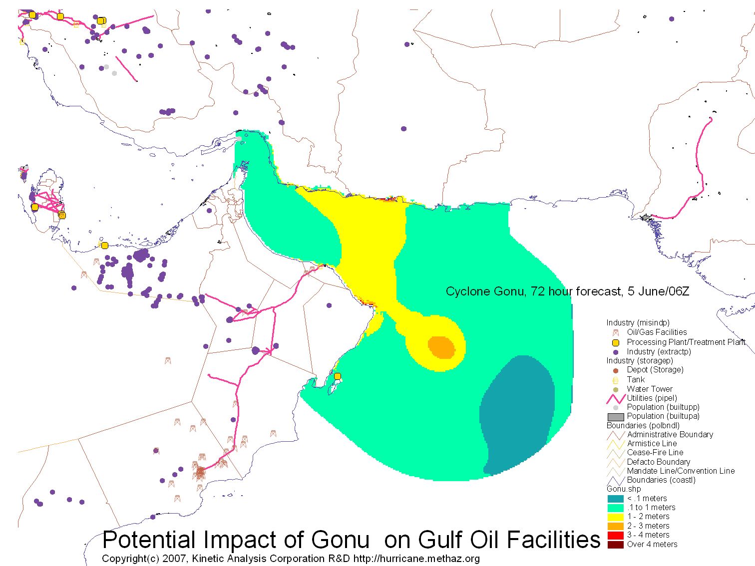
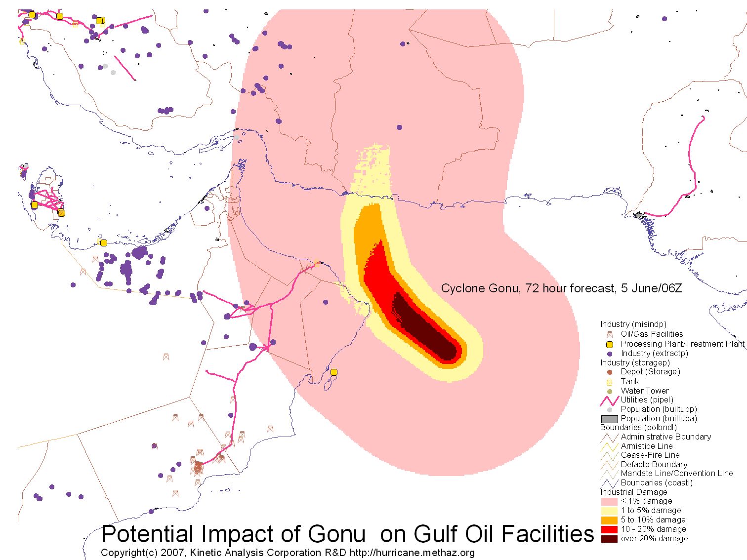
As for damage assessments, a tip of the hat to Kinetic Analysis Corporation (affiliated with the University of Central Florida). Early estimates of damage and tracking are available here (Scroll down to Gonu). Here's a graphic:

Chuck Watson of KAC/UCF has also been kind enough to send us some graphics of the storm surge model with the current forecast:
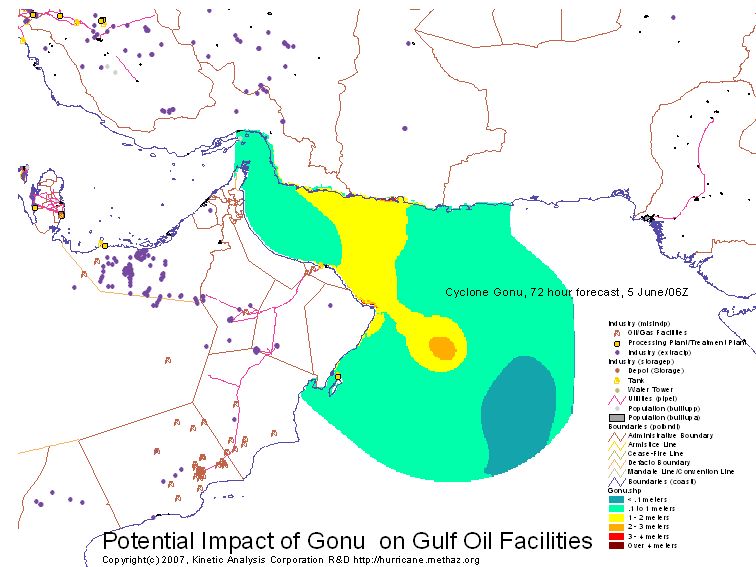
(Click here for a full size surge map, and click here for the projected damage map.)
Also, click "there's more" below for more graphics and links, and there's much more from our readers in the comment thread as well...
Here's a link to a map of land-based oil assets on the peninsula.
Regarding GONU...
http://news.google.com/news?hl=en&ned=&q=gonu
Sorted by date...
http://news.google.com/news?hl=en&ned=&q=gonu&ie=UTF-8&scoring=n
![]()
http://wwwa.accuweather.com/news-blogs.asp?blog=andrews&date=2007-06-04_...
--I can say with confidence that this forecaster has never seen the likes of this
If you go here, and click
on the North Indian Ocean links, you can get a feel for how rare this is. From 1995 on, no tropical storm of any strength ever reached the Persian Gulf.

Contact
- Content: editors at theoildrum dot com
- Tech support: support at theoildrum dot com
License

This work is licensed under a Creative Commons Attribution-Share Alike 3.0 United States License.
I didn't know they got hurricanes in the gulf
Boris
london
They are called "cylcones" ... in the Indian Ocean ... but as you say too rare in Arabian Sea to have a special name.
Seppo Korpela
New GONU thread on front page as of 7:30am EDT, please put all NEW insights, links, and resources there--feel free to move the germane stuff from here over there as well into the new comment thread.
Cheers,
PG
Storm wont hit Saudi oil hub, Oman on high alert
No worries people! Everything is gonna be just fiiiiiiiiii.............
A Dubai-based shipping agent also said no official warning had been sent to his company.
"If it was dangerous, we would have been informed," he said.
Faith, a many splendored thing.
In a comment which ended up not posting itself correctly, I pointed out that the element of surprise is going to play a major, major role in magnifying any damage.
This happened in 1999 where I live in Germany - a truly respectable pocket hurricane blasted through on Dec. 26 - and most people had no idea of what that meant.
I haven't heard the term "pocket hurricane". But I'm always up for learning something new on TOD. I suspect it refers to a tropospheric V-fold event, or a very intense midlatitude cyclone. Perhaps falling along the wrong side of a well-developed bent-back occlusion.
I've seen the footage of that forest being flattened in the 1999 event. Truly amazing.
-best,
Wolf
There isn't really a good term for what happened during that storm - 'pocket hurricane' is my own invention.
It was an 'Orkantief' (literal translation - 'hurricane low' or more accurately, 'intense low-pressure system') which started in the Bay of Biscay and which then barrelled through France, Switzerland, and Germany. It was actually quite narrow and focused - but very, very powerful by any measure. There does not seem to have been any rotation of the storm, for example, and the temperature was only mildly above freezing.
But it lacked several 'normal' hurricane features - no real flooding, no real severe lightning.
But for a number of reasons, Germany was totally unprepared for what happened -
1. Dec 26 is part of the Christmas holidays - most everyone was at home, including the weather service employees and radio/TV news departments.
2. Hurricanes as such don't happen here - meaning that no one really had any idea what was happening - or more importantly, what was going to happen. I suspect this factor will play a very major role in the Persian Gulf.
3. The weather had been freezing around a week before the hurricane, but everything had thawed in the heavy rains in the days before the storm - this is a major reason why so many trees were uprooted - of course, about half of the trees which were destroyed simply snapped in half, but of the remaining half, if the ground had been more firm, they likely would have survived better.
Hurricanes don't usually produce much lightning.
My memories are from Virginia - and the thunderstorms before and after a hurricane were always very, very impressive.
This was one of the things that made Agnes so interesting to a child - it rained for days, but only rarely was there any lightning, so we could all play outside in the downpours, and watch the flooding first hand at the local creeks.
Generally, these are just first hand impressions describing personal experience.
I am amazed that so far there isn't much reaction. This isn't even on the CNN homepage. And oil prices, while up a little, are not reacting much. Yet.
Dante at PO.com says oil is up 3% in Europe, on shipping concerns.
there is a live chart on the right sidebar just above the site meter showing WTI front month crude, which is up $1.35 -or about 2% just before noon EST. Nat gas up 4% but I think that has more to do with refining arb than the hurricane - how much LNG do we get from Qatar? Not alot now but in 5 years, yes.
AP thinks Gonu is partly to blame:
Word is starting to get out. Posted 12:08 pm
http://www.bloomberg.com/apps/news?pid=20602099&sid=a79exNcmifwE&refer=e...
"Category Four storm...the U.S. Navy said"
Who'da thought that the Navy would have their "stealth" cyclone weapon working so quickly? Now, just got to learn how to aim it.
The Weather Channel has picked it up now, as well...
http://www.weather.com/newscenter/tropical/index.html?from=wxcenter_news
Franc (penguinzee)
Saudi Arabia has a pipeline from the Persian Gulf to the Red Sea that can carry (from memory) 4 or 5 million b/day for export to Europe (plus internal demand and petrochemical feedstock).
I would hope that they are shifting to that now.
I think that we will see complete unpreparedness in the Persian Gulf. Winds may not be that high but the winds might exceed design limits.
Any thought on storm surge into the Persian Gulf ? Would even half a meter disrupt loading platforms etc.?
If I were a tanker captain heading for the Straits of Hormuz, I would stop right now and wait for developments.
To the lee of Qatar might not be a bad place to be.
Best Hopes,
Alan
Anything electrical in its path is probably going down for a week or two.
It would be nice if a reader had a map of the oil assets in and near the persian gulf (we are spoiled at TOD)
I am also curious if the installations in that area are not as fortified as they might be in the GOM which has periodic hurricanes - to my knowledge theres never been a hurricane IN the persian gulf - would be kind of tough to maintain the velocity at the exact course (unless it was steered by the Russians of course...;) Would a CAT 3 do damage anywhere?
Yep, here's what we need:
a) A topo of the whole peninsula (I am guessing the answer to Alan and Nate's query is that KSA is pretty flat, ergo storm surge will matter...)
b) a map of the oil assets, including rigs, ports, pipelines, etc.
c) is there anything oil related on the Indian/Pakistani side of the gulf?
d) and of course, anything else related...all links, etc., welcome down below.
For an idea of low-lying areas and population centres, try http://www.flashearth.com/ (needs Flash plugin)
Choose 'Microsoft VE (labels)' from button menu, and type 'Oman' into bottom right search box. Lat/Lon is given on the map - Gonu is expected to hit around 22.0 N, 60.3 E.
Zoom etc. should be the same as Google Maps/Google Earth.
Offshore Rigs
Many of the Gulf of Mexico offshore drilling rigs have been redeployed to the Persian Gulf. So they can withstand the minor winds that will be left by the time Gonu hits Oman.
OTOH, production platforms are site specific and designed for local conditions. And these are the ones that matter !
I still believe that winds will be a trivial problem inside the Gulf, waves a secondary problem. My major concern is over storm surge.
A wall of water is being pushed through the Straits of Hormuz. Will this be enough to cause significant problems ?
The path is the WORST case for storm surge !
The winds to the Northeast of the eye/storm track will be forcing water into a funnel. The outer winds at "just" 80 or so MPH, those closer in with even more force.
Alan
Really? What, no more oil to be had in the Gulf of Mexico?
More like the Saudis were willing to pay more money for the rigs and outbid everyone else.
I think you misunderstood. There are basically a number of different structures in the offshore oil business. The first is the drilling platform. This just drills holes. It does not produce the oil or have anything else to do with production. It is these hole drillers that have been moved to Saudi Arabia with the lure of more money over there than here.
But once the hole is drilled, a production platform is placed over the well (or more often, over several wells) and it collects the oil for either piping to the mainland or to be loaded onto ships for transfer to the mainland. These production platforms are still in the Gulf producing even as we write.
And note that not all drilling rigs have moved out of the Gulf, just a sizable fraction. There is still drilling occurring just at a greatly reduced rate from before.
Ghawar Is Dying
The greatest shortcoming of the human race is our inability to understand the exponential function. - Dr. Albert Bartlett
Thanks for that!
Staring at the map, it appears to me any storm surge traveling up the Gulf is going to get worse and worse as it approaches the Straits of Hormuz from the outside. The Gulf of Oman is basically a funnel as you say, and it narrows to significantly less than the width of the storm, seemingly offering ample potential to concentrate the surge energy. So the worst affected resources would be those on the Omani or Iranian coasts close to the Straits of Hormuz, but on the outside of it.
Inside of the Straits, it seems like any surge will be spreading out from the restriction the Straits pose, and thus losing height/energy. So there will be less effect there.
Think of the volume of water being forced into the Persian Gulf over several days.
It is not kinetic energy, but potential energy.
Alan
The Persian Gulf is quite a bit bigger than the storm. Even if half the water in 15' surge under the storm made it into the Gulf (probably not likely), it seems to me it's only a few feet of (slow) rise up Gulf.
Conditions close to the Straits, however, would seem likely to get... interesting.
Stuart,
I do not see this as a "total volume under the cyclone" issue but as a rate x time issue. Thus What is the current through the Straits of Hormuz ? is of vital importance.
If Gonu stalled in the Arabian Sea for an extended period, she would pump water into the Persian Gulf until an equilibrium was reached.
In addition, early rains preceding Gonu will have a small impact of the level of the Persian Gulf.
You are correct that the impact will be a slow rise in water levels in the Upper Persian Gulf plus whatever wave action modest, tropical storm winds will create.
Alan
Yes, oil is produced offshore from Mumbai (aka Bombay). There are several oil rigs in that region and I think they produce most of India's oil & natural gas.
anyone have any linkable resources on this?
The "bad" part of the storm will still be the NE quad right? So, India, Pakistan, and Iran should also feel this a bit...even if there's no direct pop...?
Here is some information on the Bombay (Mumbai) High oil platform. It gives information regarding location, size, capacity, etc.
http://www.mace.manchester.ac.uk/project/research/structures/strucfire/C...
They had a pretty bad accident a couple of years ago when a ship collided with the platform.
Hello Suyog,
Thxs for the info. So, inquiring minds want to know: did the insurance companies do a 'hit' on the Captain later for screwing up so badly? =(
Cyclones are not unusual there, though, are they? I would think they'd be prepared to handle this.
Cyclones are very unusual in the Arabian sea which is along India's west coast. They are very common in the Bay of Bengal which is along India's east coast and south of Bangladesh.
Well,
the storm may have to negotiate these on its current track:
From Wiki: Geography of Oman:
The Jebel Akhdar, Jabal Akhdar or Djebel Akhdar (Arabic: الجبل الأخضر meaning The Green Mountain) is a mountain range in Oman, extending about 300 km northwest to southeast, between 50-100 km inland from the Gulf of Oman coast. The highest point, Jabal Shams (the mountain of the sun), is around 3,000 metres (around 9,800 feet) high [1]. It is the highest point in Oman and the whole of eastern Arabia. It comprises the central section of the Jebel Hajar range, and is located around 150 km from Muscat.
Methinks, off the top of my head, that even Cat 1 winds will wreak havoc wherever they appear. For those of you not familiar with hurricanes, Cat 1 is 74 mph sustained winds (120kmh). Add in the total lack of experience in dealing with this kind of storm, and the seemingly total surprise at its emergence, leaves me with the feeling we COULD be in some very deep trouble here.
Several factors to consider here, among them surge (mostly coastal in nature), rainfall runoff, and wind. I would be most concerned about runoff in the desert, especially in the Empty Quarter, e.g. Ghawar. I don't know the soil conditions there, but I can tell you, sand does not soak up water as quickly as you might think-having lived in Florida for a long time, I've seen typical thunderstorms wash away literally tons of sand, cars, trucks, roads, etc. Depending on what happens (and this is pure speculation) I wouldn't be surprised if a land-based pipeline or two broke in this storm, on top of any coastal damage.
This storm could get messy, real quick...
Franc (penguinzee)
http://www.imd.gov.in/main_new.htm
Indian Met Dept has a forecast as well. Go to the Cyclone page (link at lower left of main page). I'd post the forecast gif, but I don't know how.
Thanks for the tip.
<img src=urlOfImage>
Where you replace urlOfImage for the url of the image you want.
Folks consider that the Hurricane season of 2005 in the Atlantic also started by early June - check some historical facts at Wikipedia.
This year we already have a name tropical strom in the Atlantic and now Gonu. In the late stages of the 2005 season an atlantic tropical storm took the unprecedented path East landing smoothly in Portugal...
I think last years ZERO hurricanes in the GOM was a white elephant and has lulled people to sleep about the damages these could have when oil distribution chain margins are very thin.
Back in the day of Wind power, no-one would sail in the Caribean from September to November. It's the Oil Age, we tend to forget some simple facts about Nature...
I know that storm surge depends on the shape of the bottom, as well as the energy of the storm. I would expect prices in Europe and Asia to go crazy. $100 oil? $5 gasoline? What about the production from UAE and Kuwait? How about the Iranians? This is a stealth wildcard in the great poker game. How many US Navy ships are in the area?
Oilmanbob,
Great point about storm surges. Let's take a look at the bathymetry of the strait.
www.lib.utexas.edu/maps/middle_east_and_asia/iran_strait_of_hormuz_2004.jpg
Nice depth map, Rex.
One thing to look at is the depth of the water itself. Cyclones need about 200' (60 meters) of water at 80°F (27°C) to sustain itself. Looking at that map, you could say the storm will start to weaken by the time it reaches the northern end of the Gulf of Oman (you could draw a line from Al Fujayrah across to Jask-this is likely where that will happen). Before that, you also have to consider the mountains in Northern Oman-besides disrupting storms, mountains can also be a source of water flooding-if this is a heavy rain event, you will see whole towns (not to mention any oil facilities) wiped out in a flash.
Franc (penguinzee)
Good points about strength.
It seems to me that the storm surge is the story to watch, along with any ships that get stuck in the strait.
A side effect of this is that there are two carrier groups essentially trapped in the gulf. No immediate issue but you can imagine a sequence of events which renders this situation even more undesirable.
Issue? Just when, in Newspeak, does an issue become a problem? I'm getting sick of every problem being downgraded to an issue. Similar to 'Likeosis' , Issueorhea is becoming as prevalent as usury.
I suppose I'll just have to add it to this list with 'try and', 'different than', and so on.
Another current favorite is 'To tell the truth', which is just a verbose way of saying 'frankly', which has almost disappeared. It also implies that the speaker doesn't always do so, which makes me marvel at its popularity.
To tell the truth I'm, like, sooo out of touch with the issues.
Usually when something is immediate it is a problem or a threat, but calling a hurricane an issue? We've gone a long way baby.
Hi Petrosaurus,
Sorry you're not enjoying my prose.
I don't use "to tell the truth" for exactly the reason you stated. I don't mince words, I am trying not to be inflammatory on TOD, since it seems to happen naturally.
The "issue" I was referring to was having two carrier groups locked into the Persian Gulf, not the hurricane itself or its direct effects.
My point was that while the CG is not in immediate danger it's easy to see why we wouldn't want to stick two in there in the first place. Tonkin Toys? Maybe. In any case I'm not the droid you're looking for.
Have a nice(r) day.
You Dont like the "Nik Naylor's" of the world?
Petrosaurus, whats the matter, did you used to date a woman with "issues"?
$100 oil?
Don't say that. I would lose $1,000.
Just plead "above ground factors", Robert. ;)
Ghawar Is Dying
The greatest shortcoming of the human race is our inability to understand the exponential function. - Dr. Albert Bartlett
LOL!
Quote of the day..
And in further comment, I honestly do not see how this could produce $100 oil unless the cyclone entered the Persian Gulf proper and then caused massive storm damage, which appears very unlikely. I could see an $80 blip temporarily but not $100 on this alone unless the situation changes drastically.
Ghawar Is Dying
The greatest shortcoming of the human race is our inability to understand the exponential function. - Dr. Albert Bartlett
it not going to 100$ on this storm but if there is damage that results in lower production from Oman, UAE, if some distribution parts are down, employees dislocated, etc. it means any further disruptions later in the year will have a thinner cushion.
Kind of like playing 'don't tip the waiter' for large stakes
Hi R.R.
Thanks for my daily smile from the line on your blog:
"By no means am I a gambler, but I am an investor."
Going to the casino to do some "investing" this weekend? ;)
Declare " force majeure"
The Company shall not be liable to the Customer in any manner or be deemed to be in breach of these Conditions of Sale because of any delay in performing or any failure to perform any of the Company's obligations under these Conditions of Sale if the delay or failure was due to any cause beyond the Company's reasonable control (which shall include, but not be limited to government actions, war, fire, explosion, flood, import or export regulations or embargoes, labour disputes or inability to ...
Tides at Ras Tanura
One take away I got from the poor predicative quality of tides is that inflows from Straits of Hormuz strongly affect tides there. and normal tides rarely exceed a half meter.
http://www.vims.edu/physical/research/TCTutorial/tideanalysis.htm
The above graphic depicts a 29-day analysis of a tide record from Ras Tanura, Saudi Arabia. The red curve is the measured water level, the blue curve is the predicted tide based on a tide model using the harmonic constants obtained from the analysis, and the green curve is the residual or the difference between the two. Since the green curve shows some pretty strong deviations from zero, does this mean the predictive model is flawed? Not really. We should expect to see some non-tidal variation in water level showing up in the green curve; in fact, the strongest oscillations that appear there have a period of about 5 days – way longer than tidal. Still, since the analysis used only nine tidal constituents to fit the data, it’s possible that the green curve also contains some minor tidal variation not accounted for in the predictive model. In statistical terms, the tide model appearing above accounts for more than 90 percent of the total variation in water level (r2 = 0.91).
The spring-neap cycle is very apparent at Ras Tanura, a big oil terminal on the west side of the Persian Gulf. The tidal type there is semidiurnal with two highs and two lows each day. But the Persian Gulf (Arabian Gulf to the Saudi Arabs) is a strange place in terms of tidal dynamics. The tide wave entering the Straits of Hormuz generate two large rotary waves for the semidiurnal tide and a single large rotary wave for the diurnal tide inside the Gulf. As you might expect, the amphidromic points for these waves are spaced far apart. To see the consequence of this arrangement on tidal type, look at the next graphic for Safaniya, a coastal town less than two hundred kilometers to the northwest of Ras Tanura.
Ras Tanura is right on the water right?...like 15 ft above MSL. Don't they have problems with erosion or something? Seems like even a little surge there would really screw things up...
What I would give to have my old job back, before I became a Chef/Author. Digital Nautical Mapping. The "Company" Which will remain nameless that I worked for, had maps of the whole area. Down to the 4th decimal place on the Seconds of Long and Lat. In laymens terms, within about 2 to 6 inches I could give you the location of something off the map I was holding, to a real world spot. Given that Most of the work at that level were 10,000 scale Harbor Charts, The fine tuned maps. I once had to Warp ( take a 2-D image to the 3-D global mapping parameters) a 10,000,000 scale map that literally was the bottom 1/3 of the globe. Not an easy task to say the least.
The Straits of Hormuz are narrow. Lots of channel markings and No-shipping zones and Things that can go bump that you really don't want to go bump.
From Mapping the entire Gulf of Mexico, for over 5 years, both as a collector of data, and as the guy that set about scanning 1000's of charts, I can tell you any storm does changes to the bottom of the ocean.
You are going to have bottom silt and sand moving about and Chaos. I would be more concerned about underwater structures than anything top side, Unless the winds are over Cat 2, then Plot the course and see what is not nailed down good enough.
MAN! I do so wish I were back where the guys used to plot every storm for what potential we'd have to go about changing in our databases.
I don't remember which Collection Datum the region is under though,,, Oh well, not really important, But I could find out some info a lot faster than I can now.
Cheers, It was going to be one of those weeks in my personal life, now it's going to be one of those weeks in the rest of the world too... Way Cool.
This place frickin amazes me with the people who come out of the woodwork with expert commentary. You must be kidding me, you are a former cartographer of the Middle East. If so by all means keep us informed on any developments you find interesting.
This may have been mentioned below (haven't had the time to read all of the comments) but in 1953 the North Sea experienced something similar, ie big storm, high tide and a 'funnelling' of the storm surge. From wikipedia's entry: "A combination of a high spring tide and a severe European windstorm caused a storm tide. In combination with a tidal surge of the North Sea the waterlevel locally exceeded 5.6 meters above mean sea level. The flood and waves overwhelmed sea defences and caused extensive flooding. Officially, 1,835 people were killed in the Netherlands, mostly in the south-western province of Zeeland. 307 were killed in the United Kingdom, in the counties of Lincolnshire, Norfolk, Suffolk and Essex. 28 were killed in West Flanders, Belgium. Further loss of life exceeding 230 occurred on watercraft along Northern European coasts as well as in deeper waters of the North Sea; the ferry MV Princess Victoria was lost at sea in the North Channel east of Belfast with 133 fatalities, and many trawlers sank."
USGS interactive map of oil fields on the Arabian peninsula:
http://pubs.usgs.gov/of/1997/ofr-97-470/OF97-470B/arabGmap.html
oil trader friend of mine says as soon as the hurricane hits the dry/sandy air of M East, it falls apart quickly.( at least in the past)
but there might still be delayed shipments, etc.
Oman expecting storm surge of 12-18ft.Armed forces on alert.Oman produces aprox 700m bl/da. Nothing out of gulf for 5 days.
Waves currently 40-50ft in Arabian Sea.Many ports are in a panic, trying to reverse loadings!
Do you have any links or citations for this information?
The 40-ft waves are reported here
What is "reverse loadings"?
Taking oil from tanker back into storage.
Thanks! Someone asked, "What does that mean, pump backwards?" I guess he was right! ;-)
They are pumping oil from tankers to onshore tank farms ASAP.
I wonder how full those tank farms are regularly, in % terms? Could they handle 3-4 days of backlog?
Market doesnt really seem to care much. Gasoline is up 3 cents for July delivery
HO up 5 cents.
I think 5 dollar a gallon gasoline is certain this summer.
This is enough of a disruption that we probably won't be able to keep the pace of imported gasoline up. A couple of hurricane scares later....
The plus side is this might force KSA to show its real capabilities this year.
$5 a gallon gas is another positive outcome.
It is the only way the US will start conserving.
Sooner is better than later.
Best Hopes for a $6 price spike#,
Alan
# GoM disruption before Oman comes back on-line and over $6 would seem reasonable.
So if they get bottled up...
Do they shut down?
How long does it take time to restart?
I don't think you can have waves that high... 10-15 feet would be more like it.
You mean in the Gulf?
Because waves over 100 ft. high have been documented elsewhere.
Yes you're right, I mixed it up with the strom surge...
Check your link BTW.
Oops. Had an extra letter in there somehow.
They are called ROGUE waves and yes they happen. They were thought to be a myth for a while, till several of them having gotten their pictures on camera and video over the last 20 years or so. Rogue waves happen just because, Hurricanes cause high seas because of the wind force and the churning of the ocean due to wave action.
New Scientist had an article on them back in 2001, I was still working in the Nautical Mapping world and Everything about the Sea was of interest to me.
The more the churn the more the damage, You really don't want to get hit by to many big waves, few Ships are safe. Rogue waves do still pop up and ships do still sink without a trace.
Since normal tides are 0.5m, then 3m-5m storm surge will probably wreck havock with their offshore production and docks.
Robert-do you have any idea of where to find inventory stats on Asian refineries? I'm guessing that a five day shut down of the ports is probably as much as they can stand without really cutting deliveries.
In the Port of Houston many tankers stand offshore and act as floatin storage, there is limited storage onshore and docking fees are very high. Is there much of that in the Persian Gulf?.
I would suggest that we write off Omani production for at least half a year. It is difficult to design loading facilities to withstand that type of surge, and there would be little reason to do so in Oman.
Furthermore, storage tanks are likely to be damaged in that type of surge.
Add infrastructure damage due to HEAVY rains (figure 1 m or more) and the need for relief to the population. Housing and essential services are likely to be heavily damaged.
Alan
This cyclone/hurricane could be the scapegoat that the TPTB will might use this year for explaining higher prices. Peak Oil will take a back seat once again.
The Qalhat LNG loading facility is near Sur south of Muscat.
It seems to be in the path of the cyclone.
http://www.hydrocarbons-technology.com/projects/qalhat/index.html#qalhat3
nice catches Alan and rainsong.
anything LOOP-ish in the area?
hmmm...storm surge modeling for the Persian Gulf. not much on google.
nothing like the USF GoM risk assessment for the Persian Gulf that I can find or anything like that either.
Does Oman, UAE, or KSA have anything like the MMS?
Just kidding.
Storm Surge modeling ?
There is some free tidal prediction software at the bottom of this link @ Ras Tunara tidal
http://www.vims.edu/physical/research/TCTutorial/tideanalysis.htm
I have NOT looked at it and do not know if it can help model storm surges or not.
I suspect no one in the world has modeled this.
Alan
sorry, I got a phone call and didn't finish typing but hit enter! *laugh*
I am sure that there's no one who has done the modeling like these folks at KAC/UCF have for the GoM...they take in to account surge, wind, everything...and all those factors' effects on assets. Invaluable tool for the GoM, if one comes.
http://hurricane.methaz.org/
Good guys too.
actually, they do have some preliminary assessment, but nothing to the detail that they would have for a landfalling GoM hurricane...but the damage maps are very interesting (scroll down, no hard link...)
http://hurricane.methaz.org/tracking/
I looked at the models and I really think that they are underestimating the storm surge. Some energy will be dissipated on the Iranian coast, but much will go through the Straits of Hormuz.
Wave action from the Arabian Sea will diminish once the cone expands inside the Eastern Persian Gulf and only new waves from the "weak side" of the cyclone will create new waves (and these will be pushing water out of the Persian Gulf).
Rainfall will be "over 6 inches" for northern Oman.. HOW much over ? I am used to 0.5 m minimums but I live in a more humid climate.
I think storm surge will be a bigger issue in the Persian Gulf than they expect.
I would love to know the currents in the Straits of Hormuz right now. Several knots I strongly suspect.
Alan
I wonder if the situation might produce some sort of tidal bore:
http://en.wikipedia.org/wiki/Tidal_bore
Extreme surfers may want to take a chance and converge on the Straits of Hormuz now, so they can "Surf the Soliton"©.
"If only his legs would hold! He already had a world record, he must be at least a mile inland, no one had ever ridden a wave for a mile! But the frothing, purling peak was miles overhead and the Barrington Apartments, thirty stories all, was coming at him like a flyswatter."
From Larry Niven and Jerry Pournelle, Lucifer's Hammer.
Cometary impact = Peak Oil in high gear?
-best,
Wolf
ugh
I have an email in to Chuck Watson of KAC/UCF. We'll see what he has...that would be very helpful stuff. No idea what they've got on Oman, etc.
Oceanweather Inc has a Gulf wind and wave simulation called PERGOS but I believe it's commercial only.
They do have a regularly updated wave height/direction map for the Arabian Sea here. It also has a Java loop for animation. Currently showing roughly 10 meters wave height at Gonu's core.
Omani production goes through the offshore PDO facility near Muscat (MAF complex) and another further south on the coast No idea what its design spec is - but a storm surge may well test its limits. The base at MAF is on the coast. It would look very strange with a super tanker parked in the visitors bay of reception, instead of mthe usual mooring 1 mile offshore. Note also that heavy rainfall could cause problems with the MAF with flash flooding and debris.
'Oman's pipeline system is mostly focused on delivering crude oil to the country's only oil export terminal at Mina al-Fahal, near the capital Muscat. PDO operates the Mina al-Fahal facility, as well as the Main Oil Line that runs to the export terminal. PDO operates approximately 1,000 miles of oil pipelines throughout the country, according to industry sources' The MAF complex also houses the countries main oil refinery.
http://www.marcon.com/marcon2c.cfm?SectionGroupsID=30&SectionListsID=30&...
Do they have flash floods in Oman often?
With only 4" of rain a year, do they even bother to build drainage infrastructure?
Had a thought. Those tankers can't go in circles in there. They have to go in straight lines and are limited to movement by the channels they travel in. They could get blown all over and split open creating an ecological disaster. Also, those countries in that area are real funny about any boats getting into their territorial waters, even by accident. Get ready for weird world.
Hurricane Zone has a nice collection of satellite imagery:
http://www.hurricanezone.net/#02a
It has that lovely buzz-saw motion.
(takes awhile to download)
US Navy Joint Typhoon Warning Center link:
https://metocph.nmci.navy.mil/jtwc.php
Thoughts on GONU:
1. It will significantly disrupt shipping from the Persian Gulf for several days. You can't safely go through a wind field like that, and there is not enough room to attempt to skirt it. Persian Gulf tanker traffic will shut down for a few days at least. This by itself makes it a pretty big deal.
2. There are not a lot of hurricanes in the Arabian Sea, because the basin of water is small (a hurricane must form above about 10 degrees latitude), and storms tend to be suppressed by dry air and there is a lot of that coming off the Arabian peninsula. I suspect that dry air is why the storm is forecast to weaken before landfall.
3. This is apparently a category 5 storm now. Hurricanes do not maintain that intensity for too long; the intensity fluctuates due to eyewall replacement cycles and other factors.
4. Water temperature will not be a factor causing the storm to weaken. This chart shows all water in the area to be extremely warm: http://www.osdpd.noaa.gov/PSB/EPS/SST/data/global100.c.gif
5. The billion dollar question is how much damage this storm will do to oil infrastructure in the Persian Gulf region. I think the answer is going to be not much. It may do some damage in Oman. Wave height alone could be a problem in Oman even while the storm is far away, especially if their facilities are not built to handle it. However, to significantly harm the infrastructure of Saudi Arabia and the other Gulf states, GONU would have to steer a course for the Persian Gulf, enter it, then make a sharp left turn, all the while retaining its strength. That's just not realistically going to happen.
6. Asia is more dependent on the Persian Gulf oil than the U.S. Watch the TAPIS price: currently $75.00, up $1.46 as of 11:06 GMT - about six hours ago.
Do you have information about how the ports, loading facilities, and offshore platforms are actually built in the Persian Gulf? Are they build to withstand even a Cat-2? Specs in the Gulf of Mexico used to be for Cat-3 til the last few years and now insurance companies want Cat-4/5 structures. Since the incidence of cyclones in the Persian Gulf region itself is so small, are the offshore facilities built with any tropical cyclone force in mind at all?
If you cannot answer those questions, then I think it is premature to say what even a weakened Gonu would do if it got loose in the Persian Gulf. I freely admit that the probability of that event appears miniscule even now but the structural integrity of those facilities is an unknown quantity at the moment, at least for us bystanders.
Ghawar Is Dying
The greatest shortcoming of the human race is our inability to understand the exponential function. - Dr. Albert Bartlett
GreyZone,
I cannot answer those questions. I suspect that they are not built to withstand anywhere near the weather we experience in the Gulf of Mexico, so if a hurricane really did get into the Persian Gulf, it would be big trouble. I just don't expect GONU to make it that far. Has a hurricane ever entered the Persian Gulf?
To my limited knowledge, no there has never been a tropical cyclone within the Persian Gulf within recorded history. In fact, I have read articles asking why there are no tropical cyclones in the Persian Gulf or the Red Sea, two apparently similar structures from a weather perspective.
I agree that the probability of Gonu getting into the Persian Gulf proper right now appears vanishingly small. Let's hope it stays that way.
Ghawar Is Dying
The greatest shortcoming of the human race is our inability to understand the exponential function. - Dr. Albert Bartlett
This news link, http://www.gulfnews.com/region/Oman/10129969.html provides some historical info and an interesting picture from the last flooding storm Oman had last March.
That was, I believe, in the pattern of monsoons or heavy rains and not an actual tropical cyclone. And note the problems they had simply with heavy rains. Imagine how much more fun it will be when there is storm surge and potentially 185 mph winds slamming Oman.
Ghawar Is Dying
The greatest shortcoming of the human race is our inability to understand the exponential function. - Dr. Albert Bartlett
Also, the weather geek URL listed below by Professor Goose states that while there have been rare Cat-4s in the Arabian sea, none have ever entered the Gulf of Oman, let alone the Persian Gulf.
If all holds as expected, the desert air will rip this storm apart... unless it's made of tougher stuff than we think.
Ghawar Is Dying
The greatest shortcoming of the human race is our inability to understand the exponential function. - Dr. Albert Bartlett
"the desert air" and the 10,000 foot mountains
Keep in mind that hurricanes have successfully negotiated the Gulf of California and struck the Imperial Valley. Let us not forget an earlier Hurricane Katrina from 1967, and Hurricane Kathleen from 1976, both of which made decent strikes in southern Arizona. These storms can be surprisingly resilient even under tough conditions, like tall mountain ranges and a large supply of dry, continental air.
-best,
Wolf
Already a very nice eye wall on this guy (or is Gonu a girl?)
https://metocph.nmci.navy.mil/jtwc/satshots/02A_041130sams.jpg
THe US Navy has issued a warning and no sail zone: https://metocph.nmci.navy.mil/jtwc/warnings/io0207sa.gif
Assuming several days of lost shipping, maybe we will soon get an answer as to whether SA really has the spare capacity they say they do.
BINGO! We have a winner. Very good point...
Saudi Aramco is reported to have 90 to 100 million barrels of storage, most of it within the kingdom.
Assuming that this storage is not damaged (and heavy rains seem unlikely in the major Aramco oil fields with the current track), they could just fill storage for a week until Ras Tunara reopens (if IT is not damaged).
Alan
Heavy rains are the secondary threat to storm surge.
Oman will get plastered, and Iranian production is at some risk of heavy rains, even though most of theirs is in the Upper Gulf.
Alan, do you have a link for thier storage?
I was looking for this to see how long they could pump from storage.
Saudi Aramco storage, like all else, is a deep dark secret (other than the pre-Saudi days). The 90 to 100 million barrel guess is based on an earlier analysis here @ TOD.
Some in Amsterdam, some in the Caribbean, most in the KSA>
Alan
Wow, that's a lot of static tankage! Is some of that just MOL restated?
Errol in Miami
Don't underestimate rain, though. Look at Agnes (not that it is all that relevant in desert conditions compared to the Eastern Seaboard) to get a feel for what massive flooding in mountains roughly 50-100 miles from the coast can do.
From http://www.nhc.noaa.gov/HAW2/english/history.shtml#agnes -
'Agnes was barely a hurricane at landfall in Florida, and the effects of winds and storm surges were relatively minor. The major impact was over the northeastern United States, where Agnes combined with the non-tropical low to produce widespread rains of 6 to 12 inches with local amounts of 14 to 19 inches. These rains produced widespread severe flooding from Virginia northward to New York, with other flooding occurring over the western portions of the Carolinas.'
As an extra note - 'Agnes had a devastating impact on the already-bankrupt railroads in the northeastern United States, as lines were washed out and shipments were delayed, leading to the creation of the federally financed Conrail railroad system.'
From Wikipedia http://en.wikipedia.org/wiki/Hurricane_Agnes
Funny you bring up Agnes.
I grew up in Pennsylvania and remember Agnes well.
Agnes entered the Cheasepeak and essentially followed the Susquahanna, between the mountains, all the way to the New York state line and then stalled out.
The rain just poured off the mountains and followed the Susquahanna back to the Cheasepeak. Conowingo dam at the head of the Cheasepek was overtopped where the railroad cut goes past it. There was real concern the whole structure would fail. So much fresh water entered the bay that the whole ecosystem was less salty for years.
Guess she didn't have change for the toll.
Alan, I'm a gulf coast resident, not an expert, but I think you are right about the storm surge. How high are the loading docks? How about the levees around the oil storage?
The tankage and oil should be safe enough, they're too massive to damage, but the transfer pumps electric motors should be flooded and fried.Power lines down, transformers blown. I doubt there is much drainage, the roads will wash out, and the workers at the docks won't be able to get to work. If I were an Omani I'd grab my family and head for the mountains. Afterwards, their fuel stations will be shut down from no electricity or workers, so everything will be a big mess for a couple of weeks, very little oil shipped, very little gasoline from the Indian Refineries near Mumbai, or the refineries at Saudi or Dubai.
"very little gasoline"
And Iran was already in the process of instituting gas rationing anyway, weren't they?
Oilmanbob,
You say that the tanks holding the oil are to massive to be damaged. Just curious, wouldn't the land they are built on be a major factor in this. Sand mostly for many or is the land more stable with a better subsurface that they are anchored to.. Water rushing by could make them unstable would be a concern perhaps. Construction codes (if any) for such an event that could now take place will determine if they can withstand the kind of pressure that the water will place upon them, plus wind perhaps.
Looking at what happened in the MS gulf coast from Katrina and how far inland the destruction was makes this something to really watch. Remember Katrina was only a 2 when it made landfall. The storm surge had been built up long before it made landfall as it became a 5, then went to a 4/3 as it turned north and faded to a 2 not very far from the shore.
Water is the enemy from a cain as you know if you live by a coast and have experience one. Wind and tornadoes are second.
Quid Clarius Astris
Ubi Bene ibi patria
In Katrina the tanks that were full were OK, those that were empty were moved, partially crushed and otherwise damaged. I saw one with the imprint of a ship hull about half-way up the side.
During the 1993 Missouri floods, I was a pipeline engineer in Ponca City, OK. We spent quite a few all nighters and contract $$ getting the tanks along the system prepared for submergence. Don't forget that oil has a SG < 1.0; the net bouyancy force can grow to some unbelievable numbers. There are a lot of failure modes: corner welds, penetrations, etc. Those tanks aren't really designed to come off the ground and hover!!
This is just for a gentle flooding. Add a horizontal flow component and the situation gets more dicey. I found one source that speaks about scouring that caused pipeline ruptures.
I also saw the damage that winds can do to storage tanks. This one was under construction so didn't have full design strength, but est. 60 mph straight winds buckled it like a cheap beer can. We made the contractor take it almost completely apart and rebuild it anew because of the cold-work that was done on the steel.
I think we're fortunate (it would seem right now), that we won't get a 'field test' of the flooding/scouring resistance in the other gulf.
This is really not the way to start June and the summer driving season!
June is starting off ugly, with the Iranian/OPEC near '100% allowable' statement on Saturday, and now GONU.
Iran sees higher oil price, warns on supply
I went out to get some juice ;-) , and came back and GONU had its own keypost!
Reading from the text portion of the navy report/forecast, and looking at the storm track so far:
The waves have already been created, and the surge is being pushed along. As Alan noted, the NorthEast quadrant is where the strongest energy ("push") is located.
Therefore, regardless of the eventual track, large waves and a large stormsurge are a certainty well into the gulf. The navy evaluation of weather conditions to the North, and the geography to the East and West in that direction, all seem to push Gonu right up the gulf. Weakening later will still allow ample energy to add to the waves, and push the surge along.
The funneling effect will make these phenomena much much much worse. Waves can travel very efficiently - i.e. with little loss of energy. They will be feeling major effects all the way to the straights in the North.
I'm off to work until late tonight but I expect to see some pretty serious trouble by the time I get home tonight.
There's past year storm tracks at The University of Hawaii (click on the North Indian years). Here's the most active past year I could find (1998):
A storm of more than about 40 knots has not reached the Arabian peninsula in the interval for which there are images (from 1995 on).
Googling "Persian Gulf Hurricane" produced only links to things like "..Persian Gulf. Hurricane Katrina..." and a reference to the parting of the Red Sea by Moses (the last time this happened?)
HA! Now that's a good one.
I think its pretty clear that unless the Russians are steering the eye through a needle (...;) this cylcone wont make it into the persian gulf with hurricane strength - but the storm surge could be a big deal. here is pic of Musandam peninsula mountains in northeast Oman
interesting. who'd-a-thought there were mountains THERE...
Not anywhere for the water that does come on to Masqat to go though...
I think you and Alan are right. This is going to be all storm surge and seeing how good Omani and UAE's infrastructure can stand the assault.
Man, those Russians are good.
But if you have mountains, that increases the chance of flooding as well.
Hello Prof. Goose,
Your Quote: "Man, those Russians are good."
LOL! [As I apply my tinfoil hat] I thought we were the undisputed world leaders in weather control with HAARP?
Bob Shaw in Phx,Az Are Humans Smarter than Yeast?
hee. :) I was mostly responding to Nate's statement of "the Russians threading the eye of a needle..." but hey. *laugh*
Totonella,
Please please, if you are going to poke fun at least get the facts straight.
The US is HAARP
Ruskies have WOODPECKER. (so named because of the sound it makes when Hams discovered it way back)
oh and you can't bet that those that watch them will be looking at the activity level over a period of time to see if anything pops up so to speak.
Quid Clarius Astris
Ubi Bene ibi patria
Speaking of the Russians, and whatever technology they may possess, Putin is getting about as diplomatically hostile towards the west as Russia has been since Perestroika. His rhetoric couldn't be any stronger lately.
His recent security speech to the Munich Conference is fascinating:
http://se1.isn.ch/serviceengine/FileContent?serviceID=PRIA&fileid=B2F6E6...
The mountains are a very critical feature for the biology of the region. They trap a layer of warm, moist air against the coast, forming clouds that don't tend to rain, but are stripped of water as they condense against vegetation. Damage to these forests could also reduce local water supplies. These forests likely arose during historically wetter periods because they apparently don't regenerate after being removed, but are sustained by fog drip.
I have never been to Oman, so would be interested to hear from anybody who has visited the coastal fog forests there.
I was birdwatching in those mountains last year. They were the hardest looking mountains I have ever seen - utterly black harsh and bare with a trace of Acacia thorn in the wadis and otherwise volcanic rocks.
They made me thing of the Mt of Shadows that guards Mordor in the Lord of the Rings.
Any rain there will go straight to the sea, there is no soil to stop it.
PS. Good birdwatching though: Hume's Wheater and Bay-backed Shrike were the best birds.
How apropos: Vlad the Impaler visits Mordor.
I think you might want to worry about that much wind and rain on the inland electrical infrastructure too.
Where's Iran's infrastructure? Looks like they're the ones who are going to get the mean side of the storm.
a darned important question. not much yet, but I did find:
http://www.eia.doe.gov/emeu/cabs/Iran/Background.html
Chabahar and Bandar Abbas seem relevant.
Here's a map of the area:
(here's full size).
So, what do we know about Bandar Abbas?
Seems an important port, a couple of refineries for heavy sour.
Chabahar has a couple of refineries too.
Yeah. Bandar Abbas would seem to be situated about where the "funnel" theory says the storm surge would be worst. The Iran Chamber says:
Here's a map:
Looks like it might be fairly low-lying...
It could be that Iranian oil exports become the real story here....
Oh, yeah: Wiki says:
Also:
Nice post Stuart.
And now it looks like the storm is going to turn towards Bandar Abbas. And make landfall as at least Cat 1.
Super Cyclone Gonu projected track
The Utexas database of maps had Bandar Abbas with a tanker terminal as well, although I don't see where the oil is coming from or how big. Middle east petroleum map They also have a 232,000 bbl/d refinery for mostly domestic consumption...not a good thing as they are already planning rationing.
Looks like Iran may not be so lucky this time around.
The track posted here shows the storm passing nearly 200 miles east of Bandar Abbas. At Bandar Abbas, this would produce weak north winds blowing from onshore Iran, and no storm surge.
There is little likelihood that there will be significant storm surge in the Straights of Hormuz due to a funnel effect, and certainly not in the Persian Gulf. To get any such surge, the hurricane would have to hug the coast of Oman while moving northwest and retaining its strength. The forecast takes it north (Hurricanes like to go north, and when they get far enough north they eventually turn east).
I'm not saying the storm is a non-event. It essentially is blockading the Persian Gulf for a few days.
At Bandar Abbas, this would produce weak north winds blowing from onshore Iran, and no storm surge.
I'm actually surprised by this (your comment seems quite correct though - the forecast KAC simulation shows little surge at Bandar Abbas).
I don't entirely trust the models on this one. We've got a major cyclone driving a wall of water into a narrowing strait. Even when (if) Gonu turns northward it's hard to believe that there will only be 1-3ft of surge at Bandar Abbas.
Storms can still take everyone by surprise. Dennis in 2005 caused a significantly greater surge than expected because of a 'trapped wave' along the Florida coast.
The current forecasted storm track is to the east of Bandar Abbas. There is a major oil refinery at Bandar Abbas.
The Iranian oil terminals were further to the west.
Map of Iranian oil terminals:
www.humanitarianinfo.org/iraq/maps/060%20A4%20Oil%20Teminals%20Persian%2...
Omani LNG facilities might be damaged by the cyclone.
At the time of my comment, the forecast track was taking it right up the Gulf of Oman. The current track, I agree, looks to be no threat to Bandar Abbas. I guess the track forecasts aren't stable yet :-)
Of course, I wasn't suggesting it was guaranteed...just eyeballing the probability circle which is quite big at 72 hours out. Still a chance.
Something that looks guaranteed is a Cat 1 or 2 cork in the Persian Gulf.
At this rate, it looks like ships won't be able to leave/enter for about 3 more days.
At the 1/500,000 scale it is a Coastal Chart. Not great at showing you shore features, and not good at giving you much detail about soundings in the area. The sandy looking shading is part of a coastal shoaler area, but again at the scale of 500,000 That is all it tells me, which like me telling you, Hey dude, That's a Chart not a Map... Like I mentioned before, I used to have access to 5,000 to 20,000 scale charts for the whole area.... Oh well, I really don't think that the National Geo-Spatial Mapping Agency is going to be letting go of all of their data to any of us any time soon.
What about all those US Navy ships congregated in the Persian Gulf? Is there any danger to them? They always leave the GOM in a storm.
Not this time!
They have their orders, and are waiting to carry them out.
As soon as the cyclone gets into the straits of hormuz then the attack on Iran begins.
Think about it. What are the chances that a CAT 5 cyclone would head into the gulf aimed right at the straits at this point in time?
Hello Korg,
I repectfully disagree. The US would not attack when any possible escape route out is temporarily blocked by Gonu. It is also very difficult [impossible?] to run carrier deck flight ops when the ship is bucking and rolling in high hurricane seas and roaring, swirling winds if they did have to make a run for the open Indian Ocean.
But I do bet they are very much on a elevated alert level because of this cyclone. Any commercial airplane or boat that strays from its logical course will be given a miniscule amount of time to recorrect it heading. Remember the commercial passenger jet that was taken out by a missle from an AEGIS cruiser? I would think the US Navy is more trigger-ready than this sad event at the present moment--the Admirals, Captains have to be exceedingly careful of their crews.
On a different tack: what is the possibility that Gonu could move enough subsea-sand into Hormuz that it would need dredging to get the ships moving again? Impossibly high?
Bob Shaw in Phx,Az Are Humans Smarter than Yeast?
Hi Bob,
I guess we don't get many massive cyclones hitting the Straits of Hormuz.
Uncharted territory?
Hello Don in Colorado,
Thxs for responding. Another remote? possibility might be the rainfall generates sufficient mud runoff to start a subsea landslide into Hormuz. Obviously, this would be the absolute worse case for exports--could take a hell of a long time to clear for shipping. Even I think this is Nutty, WILD & CRAZY speculation on my part. =)
Bob Shaw in Phx,Az Are Humans Smarter than Yeast?
How about naval mines? I suppose there are one or two of those tethered in and around the Straits. Will the storm shake any of them loose? Would you want to be the first tanker through the Straits to find out? I imagine they will want to use all those mine sweepers they have conviently pre-positioned there to check. That would take some additional time (days?).
good point - who is our naval mine expert?
Meanwhile, over at PO.com, someone thinks it's Iran that will attack during the storm. Since the finicky, over-complex U.S. targeting and detecting technology will suffer more during the bad weather than the brute force Iran is likely to use.
I disagree.
THe bestt way for the US to have a successful strike at Iran is to have the Gulf clear of ships, aircraft, etc..
Then anything showing up on radar is a target. The worst part of this cyclone is going to hit the Iranian side of the strait and more thatn likely disable Iran for a day or two, a window perhaps. Having been on a Carrier and working flight ops, I can tell you you would be amazed at what kind of weather they can operate in. And while Iran is getting pummeled the carrier could be at the north end of the gulf and still conduct flight ops. The best window is reight after the cyclone hits Iran, no tankers in area for Iran to hit, and lots of confusion in the iranian forces. A good time to land troops and secure the Strait.
Might want to Google Paul van Riper and MC02. :-)
Hello Leanan,
I disagree with the person at PO.com, but who knows, I could be wrong.
Weather is the great equalizer in war. If Iran is going to get it's ass kicked by Gonu--I think the last thing they want to do at this time is attack the US Navy. US military satellites are way above the weather. My feeble two cents.
Bob Shaw in Phx,Az Are Humans Smarter than Yeast?
Actually, I don't think anyone is planning an attack during the storm.
And if Iran does suffer a lot of destruction, we'd look like first order bullies for attacking them at such a time.
Come on you know we will claim they tried to attack under the cover of the hurricane if we do attack.
Great point. At the minimum the scenario above would result in a regional conflict with most players lined up against the US.
Worst case?
I'm a doomer, and I don't want to think about the potential worst case result...
Not in Iran's interests to attack. What people need to worry about is that the Persian Gulf has not been hit by anything stronger than a tropical storm EVER. Everything is built down by the waters edge and nothing is designed to withstand even a minimal hurricane. What this means is, we could see massive oil infrastructure damage, and gasoline and other oil products become UNAVAILABLE at any price. At the least, oil deliveries will be disrupted and delayed for possibly weeks. Get your gas now or risk having none.
It is NOT in Iran's interest to attack, I agree. However, it is in the US interest. Remember, weather is a force multiplier and this is the worst weather they've ever seen in modern history. If the US is going to attack Iran this year then this is the optimum time IMHO. Our forces are equipped and trained for ALL weather operations, theirs are not. THe advent of a cyclone coupled with an attack will create havoc with thier command and control and by the time they figure out what is happening it will be over. Remember, if we attack Iran we have to protect the straits. No question about it. Once this cyclone rips up their defences we move in and conquer. No issues of shipping in danger or reinforcements arriving.
Isn't it just COMPLETELY FRICKIN WEIRD how all of a sudden a CAT 5 cyclone appears and heads right up the mouth of the GULF?!?!? This has never happened as far as we know. And isn't REALLY strange that the Navy, who monitors these cyclones and knew the track days ago, did not move their carriers out of the gulf as per the normal operating prodcedure???
Think about this on a larger scale and it scares the shit outta ya....
Interesting note: 2 days ago the Iranian President said that the "Countdown button to Israel's destruction had been pressed", Coincidence???
Yes, coincidence. The President of Iran says something like that every week or two.
No one can conduct an amphibious assault during a hurricane. That's pure insanity.
no one expected the Spanish Inquisition either. :)
Well, listen - it gets WEIRDER YET. President Ahmadinejad PREDICTED this hurricane LAST YEAR!!!!!
Check out this story from July 2006:
Iran president warns of hurricane in Middle East
So the IRANIANS must be the ones with the secret hurricane weapon, and they are testing it on themselves before they unleash it on everyone else!!!!
:-) (for the humor impaired).
You watch Stuart, people will take this out of context and start proclaiming he prophesized the hurricane.
Real Funny :)....Not
Example: If you had wanted to invade the Gulf Coast of the US ....OR...land a contingent of marine sabotuers, when would have been the best time in 2005??? Right after Katrina hit, chaos everywhere and no one could have stopped you or in the casse of sabotuers, noticed you. And this in a place that is regularly hit by hurricanes.
Now flash to Iran 2007, a place NOT hit by cyclones, totally unprepared. Now come Wednesday after the cyclone hits expect one of the two above actions to happen. Remember, weather is a FORCE multiplier. If we had plans to attack iran and did not do it now then one could say that our generals are bluffing or do not know shit about warfare.
My bet is on landing special forces behind enemy lines.
Or perhaps they know about international law. Iran doesn't exactly have a history of aggression towards other countries. But with the warmonger in the WH anything is possible I guess, laws be damned.
This is proof of an attack on Iran is likely.
Watch the vid, its worth it.
http://rvincoletto.multiply.com/video/item/124
The Apple iPhone is the reason they're going to invade Iran?
Weather negates technical advantage, can reduce skill advantages but does provide concealment for small unit operations. This kind of weather is a big negative for large unit coordination though. Definately not a force multiplier IMHO. US special forces have been in Iran for over a year gathering intel, confirming targets. We don't need a hurricane to take off from Afghanistan or Iraq, and jump out of a C130 on a nice starry arab night. In fact this hurricane will put some missions behind
schedule.
Sorry I have no links to support my thoughts.
Regards,
Gunga
Hello TODers,
This is a fascinating weather development. Not ignoring any possible storm surge, wind, and rain damage so well discussed by other TODers already: any guesses on a mega-sandstorm once this gets well onshore? How quickly can the affected people clear roads, equipment, etc from drifted sand dunes?
Is the electric spiderweb strung along high aerial power towers [what is the wind-rating for these towers?], or is it ground-based? Any shore-based desalinization/potable water plants likely to be destroyed by storm surge? These people could care less about exporting any FFs if they are desperately trying to restore minimal water operations before they die of thirst. I wouldn't blame them--> water is always Priority One in a desert.
Bob Shaw in Phx,Az Are Humans Smarter than Yeast?
this is what most optimists/cornucopians miss when viewing peak oil - we live in a REALLY complex world - cheap oil allows us to call up overtime crews to clear sand and water, work on infrastructure repair and replacement, etc. Expensive oil, or unavailable fuel, causes domino effects that are very difficult to predict or model. Our systems are built on the assumption that anything and everything can be repaired relatively quickly - at some price. Those assumptions will be called into question in the next decade.
Joseph Tainters work on decreasing returns on increasing complexity comes to mind.
Nate, the history of life on the planet, not to mention of the universe itself, is, among other things, a history of increasing complexification of literally everything. Human life represent higher order biochemical functioning than, say, dinosaurs, which themselves reprented a higher order functioning than what went before them. With increasing order (complexity) also comes increasing stability, with examples too numerous to mention.
But let me give one. The world economy is much more complex now than it was in, say, 1928, and is much more stable than the economy of that time.
Increased and continuing increasing complexity is the stuff of what the future is made of.
i disagree. we have increased complexity because we've had an enormous per capita energy gain which is now in decline. Even the IEA mentions that heavy oil is going to use up 20% of the total energy it produces compared to 5-6% in the case of high quality crude. Have you read "The Collapse of Complex Societies"?
and the world economy appear stable on the surface only -but just under the surface one can see the systemic risk posed by a simultaneous upward shift in % of economy devoted to transportation and energy. There is not the diversification of transport methods there used to be - liquid fuels is used for rail, ship, air, and truck. Also, most areas are now completely dependent on imports from low costs producers in other areas.
I wrote about this here
Look at your own life or that of some of your friends - as they add soccer practice, violin lessons, wedding shower, a new cell phone, dinner with bosses cousin, workout at gym across town, do your taxes, dentist, doctor, internet blogs, retirement plans, etc. do you have as much quality time to read a book and play with your children? And if you multiply the above sentence by 'continuing increasing complexity' -does it take more or less to bring down the whole system?
Decreases in net energy must be met by decreases in complexity or increases in efficiency- otherwise we stop growing, period.
I've read the Collapse book. Didn't find it too helpful.
I agree a decrease in net energy can decrease complexity, but only below the threshold where efficiencies can no longer meet reduced supply.
Hypothesizing about the effects of decreased energy supply is one thing. Assuming the world will actually see a net decrease is another---this assumption is, in my mind, a guess, and not a very good guess at that. Success with nuclear fusion, for instance, will obsolete hydrocarbons in quick measure, my point being not to discuss "will fusion succeed," but to indicate that nobody knows the future, which is my basic problem with most posters on this and other forums.
I certainly do not know the future.
So far, energy per capita reached a peak in 1980. And on oil alone, by the only measures we have seen, it used to be over 100:1 energy return - dropped to 20:1 in the 1970s and is now between 10-15:1 - (this work done by Professor Cutler Cleveland and Charlie Hall) Finding costs as per John S Herold are over $30 per barrel, whereas oil in the ground from previous discovery is in teh single digits - the good stuff has been found.
I know that at some point in the future, (and I have written about this extensively on this site), a drop beyond point X in net energy means we either stop growing, or an increasingly large % of the population will have to work in the energy production/distribution sectors. I am unsure what 'X' is - but it is a discrete number and I will happily change my hypothesis,(
Nate, yours speculations draw one of several possible futures. Another possible future---the more probably in my mind (and FWIW Simmons would probably agree)---sees a transition, without too much societal cost, into the next (call it mineral/solar/whatever) dominant energy source. Peak oil represents a transport fuel problem. Personally, I see considerable room for efficiency gains in solving the transport problem even without new means of travel or new infrastructure, which we'll surely see. For instance, for the cost of one tankful in my wife's car, I run my little scooter almost a year.
I think you might want to further research your notion that energy per capita peaked in 1980. I'm relying on MIT, among others, for a different understanding.
Hello, Mr. Plains
The suspension is getting to be too much! Are you BenjaminCole's long lost little brother?
If not, could you please post some links or something to help Nate "further his research"?
"I'm relying on MIT..." Yea, and ExxonMobil's got my back! Holla! =P
You and Nate can do your own research. Try the EIA, which reports that total energy use per capita in the US grew 3-4% thereabouts from 1980 to 2005. Total energy use growth per capita worldwide is way above that---because they are in the industrial growth cycle, because they haven't the benefits of efficiencies we do, etc.
That's the problem with these websites: people, like Nate, say things ("total energy use per capita peaked in 1980") that 1) carry important unquestioned assumptions and 2) are flat out wrong. Then if someone does inject a bit of critical thinking into the dialogue, people like spudw pipe in with vapid, informationless comments intended, surely, only to goad.
OK.
In the top spreadsheet on the EIAs website, per capita energy consumption in the US was 344 million BTUS in 1980 (the all time peak at that time). In 2004, the last year on their page, it was 343 million BTUS per person. We've been in a 25 year plateau. Your 'unquestioned assumption' of 3-4% growth would have meant a doubling of per capita energy consumption to 720 million BTUs per person by 2005 (using the midpoint of your stated figues of 3.5%) - but in reality there was not a doubling but a small decline.
Im not not trying to goad - please show me where your source differs.
Nate, try pages 38 and 299 of the EIA Energy Review 2005. Page 38 gives info to calculate per capita energy consumption for the US, page 299 for the world. US growth from 1980 to 2005 is >3%, for the world >4%. Add in efficiency, which reduces demand per unit of (GDP, heating, whatever), and one can speculate that those figures do not represent maximum rates achievable (in other words, we have untapped energy supply capacity).
Here is the EIA link with the calculations done by them - all the way back to 1949.
US Per Capita Energy Consumption (column 2)
It turns out that 1979 was even higher than 1980 - we have not consumed as much energy per capita in any of the 27 years since.
And energy supply capacity and efficiency were not the unsubstantiated claims you suggested I was making.
my source is the United States Department of Energy branch Energy Information Agency. This traditionally most optimistic of sources itself is a bit misleading as it shows North American per capita energy consumption only from 1980 onwards with 1980 being the highest year (tied with 2000)so it looks like a naturally declining trend. But 1980 was also the peak as per capita consumption had been rising up until that point - this can be verified by a variety of energy databases including BPs and any of the population/census databases.
What is the MIT link?
Also, if you back out a 40% increase of energy consumption in the middle east (which I could argue alot of which wasnt used by 'individual people' but on energy infrastructure itself, then the world as a whole is already in decline (per capita). Basically population has increased faster than energy production.
serengetiplains,
Nate, Prof. Goose, Stuart, Robert, Heading Out and many others on this site provide incredibly valuable insights into our world of energy. Sticking your head in the sand and claiming that nobody knows the future is a disservice to this site and these contributors.
Their purpose is to understand trends, reveal the known, the "known unknowns," and hopefully help the world to create adaptive capacity to handle the "unknown unknowns." If you didn't find Collapse helpful, maybe you can try "Panarchy: Understanding Transformations in Human and Natural Systems" (edited by Gunderson & Holling). Or even check out the Resilience Alliance. Adaptive capacity is like having not only a Plan A, but also a B, C, etc... so that you maximize your chance of success in a variety of potential futures.
It's one thing to plan for the future and another to wish. Which are you attempting to do?
I don't believe that, and you didn't provide any evidence, so.... the examples I know of point to the opposite, complexity is a relatively short-lived phenomenon because it tends to be less stable. You can't get more stable than very simple. Of all the systems that exist in the Universe, only a minute fraction are complex and stable. Our perspective is highly skewed because we live in that tiny part that is complex and stable.
The normal state of the Universe is diffuse clouds of gas, or dead lumps of matter. Not much complexity there.
Those "higher order biochemical functioning" dinosaurs encountered a very low order non-functioning piece of rock. The rock won that round.
What goes up also goes down.
It is my belief that the only forward pointing function in the universe (Entropy always increases) leads to the understanding that complex systems must develop and become more complex.
Because complex systems create MORE entropy than simple systems (through organizing other systems into low entropy ones, creating more entropy than the original system could have) humans are now in a deadlocked race to get off the planet earth. Therefore complexity begets complexity, whereby the rate of entropy generation goes up exponentially at each level of complexity. (Pretty much humans are good at hastening the heat death of the universe!)
Maintaining society costs energy, lots of it. The web costs electricity(massive server farms and computer processors), the highest quality energy we have. Cars (ICE) do work through thermodynamic transformation of heat(low quality energy)-typically chemical potential energy, with large losses.
Being able to feed the scribe to maintain the books which store a societies knowledge is quite important. Ask yourself, how many books from the pre-Roman era are lying around? Will Shakespear survive another 400 years? Will 'Elements'? Will 'The Republic'? Even from the turn of the century, most stuff has been lost.
Now think about the volume of scientific papers being written today. How many will be useful in 10 years?
I agree. Desalinization plants will be especially vunerable to storm surge. Also intakes could be clogged with sand or outright destroyed.
This bizarro cyclone/hurricane is also an excellent example of changes in weather we have experienced here so far this year. I much prefer Climactic Change to Global Warming to explain some of these phenomena. It seems much more appropo.
If the weather/climate is changing, what is the new norm? Airdale talks about weather "spikes". Is this just another "spike"?
Fasinating in a morbid sort of way. What a period of time to be alive.
May we all live in interesting times.
Unless there are a lot of super-tankers just hanging around wating for a spec load that any oil that doesn't go in the regular flow will get added onto the final shipments, say in a 100 years time? Or at least get spread out over a long period. If the shipping capacity is 10mbd then we can't ship 20 tomorrow to make up for the loss today???
I wish we could afford the life we are living.
"If the shipping capacity is 10mbd then we can't ship 20 tomorrow to make up for the loss today???"
Good point. Anything that doesn't ship, doesn't get made up for. Also, consider the delay in arrival of shipments.(and the timeframe could be significant) This could be very ugly. But, that's what happens when you have just-in-time delivery and operate at maximum limits.
If the straits are closed for six days, or if the overall effect is this long because tankers now unloading must later be reloaded, world stocks will go down 100Mb.
John - what are world stocks now?
In theory, if there is no damage, only delay, they would have to build up those stocks again - so if they did it over 1 month - that would be 3 million extra demand per day - over 3 months would be 1 million per day, etc. I should think this would put a bid under oil for the near term, even if there is little damage. US NYMEX closed for the day with july crude up $1.10 to $66.12 - December was up $1 to $69.6. As of yet, the collective wisdom of the oil traders is this is not too big a deal.
From the most recent IEA OMR.
So, if the speculation on this thread says 100mb will not be delivered over a weeks' time, does that mean we would fall out of range (and from the looks of it, well out of range)? Would be nice to have more up-to-date numbers, but we will have to do with this for now.
Bloomberg is now featuring GONU:
http://bloomberg.com/apps/news?pid=20602099&sid=aWFd1sNoXnA0&refer=energy
Mentioning evacuations underway, 7,000 people so far...
Betcha WTI will be @ $70 by week's end...
Franc (penguinzee)
I'm surprised to see this - I thought oecd had been steadily drawing down stocks since oct peak...
IMO this does not tell the whole story. Higher price for tapis implies lower stocks in the (much higher populated) east.
China filling its own strategic petroleum reserve could be having an impact on the price of tapis.
We're always dicing and slicing the numbers. If I could get people to just look at the bottom line numbers for crude AND product stocks, we'd all better see the trends.
And for the US, they've been steadily rising for months. Please look on the EIA latest report under the section Stocks, line 2.
http://tonto.eia.doe.gov/dnav/pet/pet_sum_sndw_dcus_nus_w.htm
The reason the MSM get's away with misinforming is because each week they reveal the least negative number in the most positive terms. It's like saying one week my cash balance is positive because I took money out of an ATM, and neglecting to mention the 1000 inch plasma that went on the card. Then the next week saying total debt went down (minimum payment) but omitting that the cash I took out of the ATM was used to purchase crack.
"As of yet, the collective wisdom of the oil traders is this is not too big a deal."
Nobody's amygdala has any pre-existing connections to the cortex for the event "hurricane in the Persian Gulf". So the collective vote of emotional significance is ungrounded. Neural networks don't do well at classifying data when there has been no training set. Have to fall back on serial mode rational analysis which takes longer.
excuse me while I go update my priors. *snicker*
(that's for you Bayesians...I know you're out there...)
Which is the problem that people have with accepting a global peak. Worldwide, supply disruptions and price increases have historically been followed by increased supply. While this is true on a global basis, it definitely not true on a regional basis, e.g., Texas, Lower 48, North Sea, etc.
So, we have no case histories of what can happen to Persian Gulf area oil production and refining assets when hit by cyclones, but we do have some recent case histories of what happened in other areas.
That is both funny and true.
I tell you, he's on a roll...
I am not thinking so much of the stocks themselves, but the ability to move it to market. If shipping is disrupted for 1 week, for example, you cannot just double up tankers the week afterwards to make up for it.
Recall how we talk about peak oil as the problem where the reserves aren't important - it is the ability to produce that is key.
"Gonu" is not to be found on the BBC, CNN or CBC websites.
This thing will be a big surprise when it does hit the news.
I wish we could afford the life we are living.
you may be correct that it is not covered in mainstream media, but I assure you that oil traders are on top of this info (in fact, i found out about it from a trader at 8am). There are hundreds of analysts poring over info on events like these and the consensus aggregate dollar vote is that it is slightly bullish for oil prices.
HOWEVER, as we can see from info in this thread, these analysts would not have too large of a sample size of historical info to make judgments on -
Im sure by tomorrow night our time (Wednesday Oman time -there is an eight hour time difference)
I told my friends in the coffee shop this morning that a huge hurricane was close to the Persian Gulf.
They thought I was completely nuts ...
Had you told them a tropical cyclone was heading for the Arabian Gulf they may have understood better:-)
21st century terminology for the 21 st century.
Um ... you want to keep things simple with these guys.
You'd lose them with cyclone ...
deleated
Understand, but my point is that the general public may once again attribute any change in gasoline prices to a conspiracy because: "We ain't never heard of no storm over there."
I wish we could afford the life we are living.
Weather Channel just dismissed it as predicted to strike "generally unpopulated areas". These people haven't a clue.
Here are the top stories on the major news sites as of 8:30 PM EDT:
MSNBC: Stunning Setback: Charges dropped against Bin-Laden's driver
CNN: Congressman faces international graft charges
BBC: NATO condemns Putin missile threat
FOX: Gitmo cases in chaos
Scrolling down doesn't help as there is no mention of Gonu anywhere on the front pages of these news sites. Yahoo! News also has no front page reports on Gonu.
This may sound tinfoil hat, but I'd argue that the Iron Triangle is doing its job extremely well this day!
PO and Gonu probably being sustained by mostly Peakoil.com and TOD. PH keeping things in perspective. We are so toasted.
};-|
Ya...besides the energy-related consequences of this cyclone...it's just frickin' freaky weather. In a perverse way, people usually love this kind of abnormal disaster in the making. Usually the MSM would run this type of thing until they were blue in the face.
Why not this time?
Usually the MSM would run this type of thing until they were blue in the face.
Why not this time?
Yes, extremely odd. BBC News Online does not have the story even now. You would think it would be the top story under their Mideast section. If we have the story(and have had it most of the day), it can't just be incompetence.
Dubais and Oman oil down Tapis and Minas up $2 each
Yeah I think the traders are getting it. For everyone else first it's got to sink in and then the connection has to be made to the potential of it happening in a neighborhood near me. Katrina like reaction time though. Excruciating from our perspective, huh? The Reuters article from rainsong is good. We'll see if Gonu climbs the charts by tomorrow.
I think the traders are in a "wait and see" mode and not overreacting this time. Sometimes they do and sometimes they don't. They are not building on the speculation, but waiting to see if there is really any actual infrastructure taken down. Go figure why this storm isn't causing panic buying of futures whereas the GOM storms did.
Yes and they may just be jumping the wrong direction on this one too (by waiting). I believe on that one there was so much refinery shut in they didn't take much SPR it was gasoline that went skyhigh ($2.70 wholesale) then $78 oil. Europe saved the US with a 2 MMbpd fillup. Doubt that would be the case if this one materializes. Wonder what the world stocks picture will be like in a week or two.
Try a day or two.
That's the 'wait and see' part. Crude Stocks like WTI are sufficient today even with this demand juggernaut loose in the US.
Gasoline would be the problem and if this Gonu thing goes critical suppliers might darn near turn the gasoline tankers around mid ocean. Only thing is right now world crude stocks are pretty good too.
Think the traders are sidling up to the tables and acting coy. Temporary disruption, draw on the tanks for a while. Any infrastructure gets hurt and the pretense will drop like a rock.
Yep ...In calling Gonu a Cat 5 The Weather Channel said there has never been anything higher than a Cat 3 in the Gulf of Oman previously recorded. (BTW they finally mentioned that "a lot of oil" normally comes out of this area, too) Now that'll get their attention!
I've been a weather junkie for decades. One thing I've noticed is that the weather patterns are just that, patterns. Look at the 2005 hurricane season versus the 2006 hurricane season. Hindsight tells us that the El Nino's southern jet stream shears the tops off of hurricanes.
My point is that if the pattern for one Cat 5 in the Gulf of Oman exist, then that pattern may persist for a while, and perhaps the year.
How about 17 named TCs a year next to the oil?
Top Stories on CNN
• Ticker: Who has most to lose in the GOP debate?
• Democrats clash on Iraq | Special report
• Navarrette: Dems lack clarity on immigration
• Missing word sees Gitmo charges dismissed
• Parents deploy to Iraq, leaving 3 kids behind
• Small plane crashes into homes | Video
• Bullfighter boy learning to kill
• Divers dismantle artificial tire reef
• World War II vet's trunk turns up after 60 years
• NASCAR's visionary leader dies
Top World News Stories on Fox
• Russia Would Target Europe Over Missile Defense Shield
• Dispatches From Iraq: Death or Glory Part I
• Ahmadinejad: Israel's Destruction Getting Close
• Holocaust Diary of 14-Year-Old Girl Unveiled
• Video: JFK Plot Suspects Face Extradition From Trinidad
• Gates: Taliban Fighters Using Iran Weapons
• Hundreds of G-8 Protesters Clash With German Police
• Ex-Liberian President Taylor Boycotts War Crimes Trial
• Israeli Army Pushes Into Gaza Following Rocket Attacks
• Report: Baghdad Security Plan Falling Short of Goals
• Helicopter Crash at Sierra Leone Airport Kills 20
• Komodo Dragon Mauls, Kills Boy, 8, in Indonesia
• Turkey Asserts Right to Act Against Kurdish Rebels in Iraq
MSNBC
Putin rebuffs call for suspect in poisoning
• Karzai orders swap of slain Taliban for hostages
• Helicopter crashes in Sierra Leone, killing at least 20
• Amsterdam ramps up the nudity | Video
• Komodo dragon kills 8-year-old boy in Indonesia
• Video: Exotic cub debuts at Sydney zoo
Top News on BBC.news
• Ex-Liberia leader boycotts trial
• Missing US soldiers' IDs on video
• Greek shot in double-park row
• New controls on media in Pakistan
• New vow to spread Lebanon fight
• Launch date for iPhone revealed
Top News on AP
• Iran Hard-Liners Pay Homage to Khomeini
• Nigeria Files New Suit Against Pfizer
• Wyoming Senator in Serious Condition
• Indian Casinos Gross $25 Billion in 2006
• Ark. Researchers Use Tubes to Study Cows
• Metals Prices Climb on Supply Concerns
• Would-Be Suicide Bomber Dies in Somalia
• G-8 Security Fence Troubling for Germans
• Some Say U.S. Sanctions on Sudan Weak
• Anti-War Marine Blasts Military
• Women Prosecuted for Smuggling Children
Doesn’t the lack of mention of this seemingly important story seem just a little bit strange?
I expect it is on peoples radar screens - the odds are that it will be a huge deal to people in Oman and Iranian coast, but not too big of a deal to the world - the second the scales tip (if they do) to being a big deal for oil infrastructure, media would be all over it (except I get an odd feeling that the media themselves either have a peak oil muzzle on or are in denial - perhaps they have gotten burned reporting on Peak Oil in the past - they are used to stories that take hours to unfold, not years.)
Nate -
In this instance I believe that your odd feeling is highly accurate.
I guess we will just have to wait and see how things play out this week!
The weather geeks are on this too:
http://www.easternuswx.com/bb/index.php?showtopic=135276&st=60
there's some conjecture that it could stay strong if the dry pocket stays west...if it hits at a Cat 2 or greater, it could "pinball" in that chute.
Enhanced Infrared imagery found at:
http://cimss.ssec.wisc.edu/tropic/real-time/indian/storm/dvor-nh02A.GIF
I would recommend going to google earth and checking out the lay of the land. If the storm surge is strong and its like a funnel then at the tip its going to be bad, very very bad.
E 24 N 56.
Just one location. I tried to tell from the view about the grid, and couldn't see above ground lines, but the transformers would be.
could wipe out those storage facilities, flat flat flat.
The side that will face the brunt to the NE is Mountains, and I wonder about the surge hitting it and "bouncing back" to the south and west. don't know, but there seems to be lots of variables for the water to find the least path of resistance.
As for guys putting on your tin foil hats, are you keeping a copy of the Casper Weinberger statement to the committe, or is that a snopes too.
Quid Clarius Astris
Ubi Bene ibi patria
Gonu Alert -- Category 5 Status -- Reuters
http://www.alertnet.org/thefacts/reliefresources/TSR/200702A_02A.htm
PrisonerX:
The storage tanks are made of steel, and are strong enough to hold a heck of a lot of oil when full. Piddly little 'ol hurricane winds won't touch them. But the levees around the storage tanks, are they high enough above sea level to not submerge in a 4 or 5 meter storm surge? What about torrential rains, are there pumps to keep the area inside the levees dry? What about the transfer pumps for the oil? Will their electronics stay dry? What about the docks, will they be able to withstand 40 ft waves on top of a 15 ft. storm surge? How are they going to get workers back to the tank farms with washed out roads and no fuel because the electric pumps at the fuel stations don't work? This cyclone is going to cause a disruption lasting at least a couple of weeks, and with the tankers not operating a couple of months to get caught up on deliveries.
All right, tinfoil hat crowd, was this cyclone (1) sent by Allah to punish for the US troops in Saudi in response to the prayers of Al Quaida (2) sent by Russia to get crude prices up on the world market or (3) sent by the CIA as a cover for the US invading Iran (4) sent by Gaia as a punishment for using too much fossil fuel(5)All the fault of the major oil companies who want to distract us from their profiteering. No messing around now, I want some answers!
To early for me to answer that Bob,
but this new track that they just published did get me to raise an eyebrow. Looks a little familiar in more ways than one.
Lets see what it does, how it behaves, a better look at the eyewall and the inflows, then I may give you a real hoot.
and yes from looking at the terrain from google earth this could end up being a real mess. Where I live there is a "mapco" facility I think owned by valero. I have done a video and shot around and down inside them. big massive things for sure.
and speaking of the tin foil hats. I went to weatherwars.info to see if Scott was following and had any thoughts, and someone has hacked him and taken down the site. Don't know when, but it was up a few days ago.
I was going to copy and paste the statement by Casper Weinberger on "weather manipulation" earthquake creating and other by him to a sub committe. He said the Ruskies were way ahead of us on this and we needed to catch up. Haven't seen it disputed.
Quid Clarius Astris
Ubi Bene ibi patria
My turn in the foil hat:
If I postulated last year that right after a couple of carrier battle groups rotated into the Gulf a Cat 5 would arrive to plug the Straits, what would you have thought?
How plausible is it to attribute *any* of this Iraq/Iran game to mere greed, or the idiocy of a dry-drunk CIC?
Then again, what were the odds that Lou Gehrig would come down with Lou Gehrig's Disease? ;))
How'd he not see that coming
I thought these things were all caused by butterflies beating their wings in the Amazon. . .
so you're saying that this butterfly couldn't have been let loose by the IronTriangle and only a wild butterfly can start the chaos theory ;)
Quid Clarius Astris
Ubi Bene ibi patria
I sent it, because it was perfect timing. We were all worried about Houston. Who could even imagine this.
The good folks over at the Goddard Space Flight Center maintain the MODIS Rapid Response System where they publish enhanced image material of the Terra and Aqua satellites. They usually have the pictures ready the next day and they also maintain an archive. Of special interest right now may be the area covering the Arabian Sea, even though Gonu is only partially visible.
THANKS Lightman,
I've been looking for better images and with more detail.
I sure wish it was in view now.
would love to seem some CU detail of that eyewall, especially since its a 5 (again?). Is that emblem on the map with a 5 saying it turned into a five then. Interesting "location" if so
Quid Clarius Astris
Ubi Bene ibi patria
Category 5 Cyclone Aimed at Strait of Hormuz at Stratfor
Article claims 195mph winds
At the time of this post, they have predicted a turn towards IRAN.
No Oman eye landfall, although now it will stay Cat 2 until after Muscat and then HIT Iran with Cat 1.
Super Cyclone GONU Storm track
PG: Bandar Abbas may be in jeopardy now! Bandar Abbas has a 232,000 bbl/d refinery(under expansion to 250,000 bbl/d) and a oil loading terminal.
Muscat(oil terminal and refinery) will still get hit, but with the weaker side.
Its not the weaker side. This track provides constantly increasing on shore winds as the storm tracks the coast to Muscat. This will provide the most destructive wind direction and nearly the highest storm surge until Gonu passes Muscat perpendicular to its track. Muscat's only saving grace is it is not at the point of the Peninsula. . If Gonu is far enough off shore, then the winds will shift parallel to the coast as it passes. After that it sees the weak side of the storm.
El Nino and Atlantic Hurricanes
The Pacific El Nino event tends to be counter Atlantic Hurricane as it is associated with a southerly position of the N hemisphere Jet Stream that tends to shear off the top of Atlantic storms.
The recent history of El Nino events from wikipedia is this:
1997-1998
2002-2003
2006-2007
The last significant El Nino event was 1997-1998 as this surface temperature anomaly map from Goddard Institute for Space Studies shows. Note these maps compare the average for April with the mean April value for the period 1951 to 1981. In 1998, the El Nino is identified as the anomalous tongue of warm water in the Pacific Ocean extending off the W coast of Peru.
1998
And so here's the charts for 2005, 2006 and 2007.
2005
2006
2007
The key observation is that the El Nino that showed signs of building late last year does not have a major expression in April. There is little sign from the April 2007 map that 2007 has an El Nino event building, and by inference little negative sentiment on the Atlantic Hurricane front.
I'd also draw attention to all those brown colours in the circum Arctic area which I discussed here.
PS - it seems that Australia along with much of Africa has been writte off as habitable territory:-))
This has been an interesting day and shown the power of the intertubes to find detailed and up-to-the-minute information on what is occurring in remote parts of the world.
I think I feel sorry (to say the least!) for the poor Omani citizens who are going to get a big upset to their lives in a couple of days or so.
The average income per head in Oman is around $5,000 ...
http://www.nationmaster.com/country/mu-oman/eco-economy
So, at a guess ... they don't live in McMansions ... or even as well as the poor Americans hit by Katrina in New Orleans.
Are the changing weather patterns caused in any way by our consumption of fossil fuels? ... if so, do you feel any guilt for your part in it? ... do you think our politicians will act to stop it getting any worse?
Xeroid.
The average income per head in Oman is around $5,000 ...
On the other hand, there will be precisely zero debate in Muscat tonight about when, whether, and how deeply the national government should involve itself in relief and reconstruction efforts. In the Middle East, (in fact, in most countries), that isn't even a question.
And I doubt that the national government will turn down $1 billion in foreign in kind assistance.
Best Hopes for the Sultan of Oman being a better ruler than GWB,
Alan
OK - it’s hitting the wires right now - mostly international.
The thread out front is updated with the latest info from Accuweather, the latest plot, and the latest damage assessment from Chuck Watson's group.
We'll likely start another post for tomorrow morning...that's my guess. Keep it here for now.
Great connection to have Prof G,
very kind of him to make up that model for you, us
Quid Clarius Astris
Ubi Bene ibi patria
absolutely...we've stayed in touch since Katrina/Rita. He wasn't so busy last year, but methinks he might be this year.
Prof G,
I don't know if its the same university, but one of the researchers at a Fl. university noticed that very small earthquakes were being read when the Hurricanes passed over land. They were quite surprised and planned on specifically looking to see if they could figure out more about them.
Is this the same place and if so could you see if they have any more info on that. Curious to see if they documented it again.
thanks if can or can't anyway
Quid Clarius Astris
Ubi Bene ibi patria
In my opinion, an oil shortage created "artificially" by a hurricane is just what the world needs. It's certainly better than waiting until we have a permanent oil shortage created by geological peak oil.
We really need something to wake up the public and our politicians, so that they finally do something (energy conservation, anyone?) while there is still time.
Then again, the first big warning shot was fired in 1973, and we basically ignored it. I have doubts that this time will be any different, but I can always hope.
What I keep thinking about is what happens if this does cut down the supply and distrupt the flow for even a couple of weeks, then a caine in the Gulf that shuts down the rigs, and perhaps even worse, take out some land based industry.
Be careful of what you wish for.
Quid Clarius Astris
Ubi Bene ibi patria
Not directly related to the current cyclone, NASA has a plot of all cyclones in the last 150 years, and while there are a fair few tropical storms, there are none that track actually into the northern region which this one is heading, and i cant see any tracks that reach past category 2, and it looks like this storm could potentially make landfall in Oman at category 3.
NASA also has a nice sat. pic. of Gonu.
edit:
-how many hours from GMT is EDT?
Andrew
(in Australia at GMT+10)
on a slightly off-topic tac, a plot of the intensity of all storms for last year might be of interest to some people
Andrew,
GMT is basically the time it is in London.
You also have to determine whether Daylight savings time is in effect for one or the other. 5 hours I believe currently for the US with Daylight savings time.
Thanks for the link.
I saw what I though I might see in the blow up. I'm going to wait for others to say if they see the same thing that wear a tinfoil hat ;)
Quid Clarius Astris
Ubi Bene ibi patria
Cyclone forces Oman to evacuate 7,000
http://news.yahoo.com/s/ap/20070604/ap_on_re_mi_ea/oman_cyclone;_ylt=AqR...
Al Jazeera is pretty quiet. No weather news. Their English language weather page casually shows "Tstorms" for Masqat: http://english.aljazeera.net/NR/exeres/B5751DD0-3F72-4F53-A47D-73012E827...
DST is 1 hr ahead.
http://www.timeanddate.com/worldclock/
World clock site that I use when talking to friends in other lands and I can't figure out it calling them now will wake them or I'll have to get up at about now and catch them in my future, or their now. Round globe makes of some really odd time travel thinking. The sun is shining on a freind I have in Russia, I wonder if she is sitting reading my e.mail or having a coffee.. It is 1 am where I am a bit past my bedtime, but I love Weather Events more than sleep.
That is a good image from NASA. It confirms what the weather-geeks have been saying, that if GONU remains intact when it enters the Gulf of Oman proper it will be a historic event - first hurricane in the GoO. (Well, it already is a historic event that it was classified as a cat 5 for that part of Indian Ocean.)
Over on the weatherunderground tropical blog of Jeff Masters they are showing some sat photos of how the Omanis have built their towns right on the coast, and on the dry creek banks. Gonu is unlikey to be a major wind event for Oman, but could be the greatest flood tragedy in Oman's history - those poor people will simply be washed out to sea.
Ever been to the Bay of Fundy? Any chance of
a tidal bore type occurrence here?
bobolink, thats what we've been talking about as storm surge. In a hurricane or cyclone the low barometric pressure makes the sea level rise, and then the waves are on top of the sea. So with a 15 ft storm surge and 40 ft waves like this storm, port facilities and offshore production platforms could be crushed. Think about the effect of tons of water at your doorstep because sealevel has risen, then 40 ft. waves pounding your building, or dock for hours. The waves pick up any floating trash and it becomes a battering ram.
I live in Galveston, Alan in New Orleans. In 1900 Galveston had a hurricane that killed 8,000 people. We built a 17ft. concrete seawall in Galveston, and hauled in dredged sand to raise the city. And I'm sure you are aware of the damage from Katrina and Rita. That's why we're worried.
I've worked briefly in the MAF complex and it is built bang on the coast, in the wadi mouth with hills either side. Buildings start a few metres above sea level and only 50 metres from the shore line, more or less. The refinery is a few hundred yards inland. Sea affects could be significant - it is hard to put this into context when you only ever see the place on a calm, 40C, sunny day. The offshore loading 'dock' is a mile or two offshore. Flash floods are more known about in Oman - the rains often having the most dramatic impact miles away in areas where there has been no rain - just a sudden flood down an otherwise dry wadi.I am guessing this storm will bring a different kind of rainfall to the more usual localised thunderstorms. Local governments will not have dealt with this before so how they behave, and how the people react to any warning will be a challenge. A colleague in Muscat tells me that a storm warning has been given by the government to all Omanis. Currently dark skies and rain expected to start in the next few hours.
Apparently the Iranians think something's up:
http://www.defensenews.com/story.php?F=2799730&C=mideast
It's unlike them to make such specific threats, revealing their tactics.
Scary Link. Also see my comments above.
So when is the best time to attack. NOW. When you have the weather advantage. We can attack with various means in inclement weather. They CANNOT. This nuetralizes their threat and by the time the weather clears there will be 50 marines at each missle lancher. If the bush administration does not take advantage of this storm then I doubt they will really attack Iran.
Why are you still sitting there, Chickenhawk? Your local recruiting center would love to have you.
http://digg.com/business_finance/Cylone_Gonu_Thread_and_Link_Dump
if you are so inclined... :)
(don't forget reddit or fark or slashdot or...or...or...)
TAPIS crude oil in Asia has opened for trading, and within minutes appears to have risen more than two dollars from it's previous close:
http://www.upstreamonline.com/market_data/?id=markets_crude
At 0106 GMT, TAPIS was at $75.87, up from its close at $73.55
However, that is still below the highs of $77-79 that it has been pushing over the last two weeks..
cheers
Phil.
Tapis is up, the Chinese stock exchange opened down Tuesday morning in a third day of panic sell off. Am not sure if it will spread to other markets.
Omani electrical Infrastructure
Page 18 of this pdf.
http://www.pdo.co.om/NR/rdonlyres/5007ED42-B05C-49F3-ADF6-94709957FA24/0...
I tried and failed to do a cut and paste of the graphic. Perhaps others better skilled...
Alan
Still nothing on BBC, ZIP. Check out their weather forcast for Muscat, Oman. Supposedly Sunny on Wednesday with 11 mph winds out of the northeast.
http://www.bbc.co.uk/weather/5day.shtml?world=2426
I guess they figure if you ignore the storm it will go away.
Gonu is being covered on CNN this morning. The track has changed; it's missing Oman and hitting Iran. As a category 3, I think they said.
The weather guy is saying, "Don't worry, the oil fields are far away from the coast."
Ummm...what about how the oil gets from the oil fields to the rest of the world?
There is some good info and graphics on Jeff Masters' "Wunder Blog" on wunderground.com. I will attempt to post a link:
http://www.wunderground.com/blog/JeffMasters/comment.html?entrynum=690&t...
Everything seems fine apparently... Though surely exports will be halted for considerably longer than 6 hours and that's not even taking into account any storm damage?!
http://www.bloomberg.com/apps/news?pid=20601086&sid=aV5KgBeKRpUY&refer=news
New Gonu Thread as of 7:30a EDT. Please place new insights and resources there.
Guys - WOW, this coverage is brilliant!!!! You are all to be congratulated for your excellence of technical brilliance on this topic.