| Dammit! We Wasted a Day of Sunlight! | The Oil Drum | Bioplastic - Better Living Through Green Chemistry ? |
Hurricane Gustav and Energy Infrastructure - Early Open Thread
Posted by nate hagens on August 27, 2008 - 12:08pm
(Welcome: we are now on a later and more updated thread, which can be found here: http://www.theoildrum.com/node/4478 NB: you may want to just go the front page (it will be post #1 or #2) to get to the most recent thread: http://theoildrum.com ...)
By now most people know that by this weekend there will likely be a hurricane spinning its way somewhere in the Gulf of Mexico. This open thread outlines the initial analysis by Chuck Watson/KAC/UCF and some resources on GOM oil and gas infrastructure. ( We will try and update this with new graphs and forecasts as long as this storm is considered a threat to energy infrastructure)
(Welcome: we are now on a later and more updated thread, which can be found here: http://www.theoildrum.com/node/4478 NB: you may want to just go the front page (it will be post #1 or #2) to get to the most recent thread: http://theoildrum.com ...)
From KAC/UCF google earth link

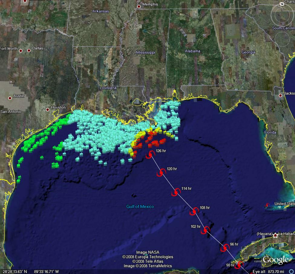
From Chuck Watson:
Both GFDL and HWRF (which will replace GFDL) are showing fairly explosive amplification in the mid Gulf. Even the official forecast is now showing damage to the OCS facilities, and GFDL is showing Katrina-like long term disruption. None of the official tracks are onshore yet, but our in-house runs out to 180 hrs are showing hits to refineries and pipelines, as well as knocking SPR off line for a couple weeks as well. Of course, estimates beyond 72 hours are more "possible scenarios" than real forecasts, and a little wobble one way or the other makes a big difference in damage, but Gustav is starting to get scary.
The Gulf of Mexico represents about 25% of overall US production, or represents 10% of US Oil usage. (*Ed. Note - I believe Nat Gas is about 13-14% of US production)
Using the 6Z 27 Aug GFDL run, we are showing some facilities off line until early December. The total loss is 12% of Gulf oil production between now and the end of the year (126 days). Interestingly, NG isn't so much of a hit - only a 5% loss of the remainder of the year's production.
I asked Chuck Watson what the odds were that this storm wouldn't even make it to the Gulf as a strong hurricane this was his reply:
20% chance it stays as a high TS/low Cat1 due to interactions with Cuba, crosses the northern Yucatan, then across the southern Gulf as a week system.
20% chance it tracks across eastern Cuba, never really gets it together and stays weak cat1 or lower up the west coast of FL (Fay like track).(this is my current favorite scenario for some reason)
30% chance it follows the current guidance and stays below cat 3.
30% chance it follows current guidance, amplifies, and is cat 3 or higher.
100% chance we're probably wrong . . .;-)
We are still 4-5 days out from a potential US landfall so uncertainty is high, though given the stakes, Gustav is becoming kind of a binary event. Chuck has put together a dynamically updating page that will reflect the latest damage models/forecasts at this link: KAC/UCF models.
On current track, which the weather geeks (and I use the term "geek" in kinship...) at http://easternuswx.com and Jeff Masters at WU say is too early to say for sure, but this could do a lot of damage.
PRODUCTION/INFRASTRUCTURE MAPS AND REFINERY INFORMATION
We have accumulated resources from previous hurricans below, but we'd like to find updated materials if you know of them. Recent refinery maps, recent rig maps in the gulf, recent gas fields, SPR facilities, the Intercoastal Canal, pipeline stations and transfer points, etc., etc. Leave links in the comments please.
Also, here's the EIA's Alabama, Louisiana, Mississippi, and Texas Resources pages. They will also likely come in handy. Also, here's a link to the national page.
Here's another good resource for infrastructure maps and such. (scroll down a bit)
Here's a map from CNN with large and small refineries laid out. (though it is an old storm track)
Very detailed piece by RIGZONE on rigs and other infrastructure in the area. (thanks mw)
Here's a flash graphic of the oil refineries and rig maps, emphasizing Beaumont and Galveston's importance. Click on oil production. Note the many rigs on the east side of the storm that will get the brunt of the damage from the NE quad of the storm...hence the high long-term GOMEX oil production damage estimates below.
Contact
- Content: editors at theoildrum dot com
- Tech support: support at theoildrum dot com
License

This work is licensed under a Creative Commons Attribution-Share Alike 3.0 United States License.
i recall when katrina hit (or was it after rita), the gov't released the SPR.
i wonder if they'll do the same. any thoughts?
The long term problem facing the Gulf Coast is the rapid decline in oil shipments from the proximal producers--Venezuela & Mexico (VenMex)--which will force the refiners to rely on much longer supply lines, from Africa and the Middle East, subject to the overall world supply/demand situation.
I had expected that we would hear calls for a release of oil from the SPR by the end of the summer, specifically because of crude supply problems on the Gulf Coast--my premise being that refiners would have problems fully offsetting the decline from VenMex. It looks like I was wrong, and to give credit where credit is due, I suspect that the primary reason that we have not heard calls for SPR releases (specifically tied to the Gulf Coast) is because of declining demand (which is Datamunger's point).
However, in May, 2007 VenMex accounted for more than 25% of US net petroleum imports, and as of May, 2008 their combined petroleum shipments to the US were dropping at an annual rate of 27%/year. Venezuela is currently on track to approach zero net oil exports around 2027. Mexico will probably approach zero net oil exports in the 2010 to 2012 time frame.
Regarding the hurricane, it looks like our key problem is going to be gasoline supplies. Using a Minimum Operating Level (MOL) of 170 mb, we have about 63 hours of supply in excess of MOL.
The US barely survived Katrina.
If Gustav hits at the same force/location
The US becomes a different place.
One example:
Will the the CSX railroad be rebuilt across the Rigolets.
And will it be rebuilt along I-10 in MS like
CSX wanted after Katrina.
What on earth are you blathering about now? Show me any proof whatsoever that we "barely" survived as a country.
"Blathering"?
Ihold with all statements I've made that the US never recovered from Katrina.
Name one thing in the US that's improved since Katrina?
Of course you think that the Financials have absolutely nothing
to do with Katrina at all.
That housing peaked in 05? Nothing whatsoever.
Come on back. Love talking to people channeling Cheney.
How do you think that bush got that 71% disapproval rating?
;}
Population and GDP.
Though I will grant that from a wide angle lens, neither of these necessarily represents an 'improvement'.
Population and GDP?
So as the pop grows we're better off with fewer resources available?
And GDP? Don't even get me started.
You wreck your car and the GDP improves.
GDP is so wrong a measurement scale I'm surprised you even brought it up.
"But, even so, there’s one thing I know, and that I knew even at the end of the day on Monday, August 29th, 2005, when I was one of the small group of people in the country who was aware the coast was buried under water, even as newscasters crowed (premptively as it turned out) that NOLA had dodged the bullet: the Mississippi Gulf Coast is never going to become a Homestead and Naranja Lakes, with grass slowly overtaking empty slabs. The surge and wind hadn’t even finished dying away when people started picking up the pieces, and they haven’t stopped."
http://www.wunderground.com/education/Katrinas_surge_part10.asp
This guy and me were on the same page that day.
I knew what a CAT 5 storm was capable of.
My school, built to withstand Katrina was under 4 floors of water
(28').
Do yourself a favor and read the series this guy put together.
To see how unprepared NOLA now is.
And the Superdome/Convention Center are off limits for
storm shelter.
I wonder how many NO natives are aware of that?
I think an interesting alternative to the GDP as a measure of U.S. economic health is
Infrastructure Quality/National Debt or
Infrastructure Spending/Annual Budget
Low spending and/or large debt, then we're not doing so well, which is the current situation.
In 2005, ASCE (American Society of Civil Engineers) gave the U.S. infrastructure an average grade of D, and said that we would need to spend at $1.6 trillion dollars, which I'm sure is now too low. Check out the link below. Its not a pretty picture.
National Infrastructure Report Card
http://www.asce.org/reportcard/2005/page.cfm?id=103
I had dinner with a couple of civil engineers recently. They said that we should expect to see more and more bridges falling down.
I concur. Even without peak oil. With peak oil, it's going to be worse.
yikes!!
do they know where?
In a Post-PO world, do we even need bridges...? At least for cars...?
Well without as many cars and trucks on them (esp. trucks) they should last longer...
Just want to say thanks to Chuck for sharing this data. I see that his work is a commercial venture but appreciate his allowing TOD to view his projections.
Thanks!
We agree! It's nice when people contribute time and expertise receiving something 'other' than pecuniary rewards.
Agree. 8D
Is there a concise update on the status of New Orleans' flood defense systems? I want to believe that they are at least back up to pre-Katrina levels, but I am skeptical...if Gustav comes in weaker than Katrina or less-directly, is there still a threat to the city?
I'm no expert but I will say this. Katrina passed East of New Orleans as a Cat 3 storm (after reaching Cat 5 in the Gulf). The east side of the storm is the more powerful, meaning New Orleans MISSED the brunt of the storm.
According to the latest models, Gustav is projected to make land just West of New Orleans, placing the city in the bullseye of the most destructive forces.
It's always something of a crap shoot cowboy as which would be the worst track for a particular storm. N.O. is actually about 90 miles north of the Gulf. If there are high winds and a slow mover a track to the east of NO could be the worst. Lake Pontchatrain borders the north side of my former hometown. Strong and sustained north winds from an E tract storm would push the whole lake into the city. On the other hand, a slow, very rainey storm settling over the city could cause more flooding then Katrina without breaking a single levee.
Regardless of the path and nature of each storm, living below sea level seldom works out well.
"N.O. is actually about 90 miles north of the Gulf."
With all due respect, Rock, NO is now on the GOM.
"It all comes down to this: You simply can't build the levees high enough under any scenario in Louisiana," said Clifford Smith, a member of the prestigious Mississippi River Commission, a seven-member panel created by Congress to advise the corps on works projects. "That the corps still doesn't act on this fact, doesn't commit to building wetlands and barrier islands immediately, leaves me so depressed you can't imagine it. I'm in depression over this."
http://www.grist.org/feature/2008/03/20/tidwell/
"The number one thing protecting New Orleans right now is not the corps, it's chance," says Tulane University law professor and coastal protection activist Oliver Houck. "The historical odds show Katrina doesn't come every day. That's all that's really protecting us right now. The odds."
And if we can't save New Orleans, is there really any hope for Miami, Charleston, New York, Annapolis, and all the other low-lying coastal cities in the queue."
The scope of the catastrophe caught New Orleans by surprise.-
NYTimes Aug 31 2005
They'll be surprised again.
New Orleans is more vulnerable than at the time of Katrina, which destroyed some 700,000 acres of protective coastal marsh according to this. Check out the video for details.
Good point Mc. I guess you could say the NOLA is actually part of the GOM that has been reclaimed just as the Dutch do. Well, not quit as good as the Dutch perhaps.
I still remember the first time I went to the top of the Plaza Tower (first sky scraper in NOLA). It was really amazing for this city boy to see that the city was really surrounded by water. Some of the water might only be a few inches deep but it was everywhere you looked.
Sure there is and it beats the FEMA trailers
http://www.n55.dk/MANUALS/WALKINGHOUSE/walkinghouse.html
This one is water, wind and hurricane proof...
http://www.n55.dk/MANUALS/MICRO_DWELLINGS/micro_dwellings.html
Yeah, but there is a lot of uncertainty in the track. Every 3 hours or so they update the forecast, and you can see the track change. For example, the 11AM shows it heading right up the LA/MS line. The next forecast will almost certainly show something else.
In the past I have seen animations for other hurricanes where they just play the sequence of forecast maps, and you can see the 5-day out path wobbling all over the place.
In a couple of days it will be easier to say where this is really headed.
Basically, they are about where they were before Katrina - could probably handle a direct hit by a Cat 2, or the back side of a Cat 3. (This from a friend of mine who did the post-storm analysis for FEMA that has yet to see the light of day . . .).
--Chuck Watson
A Stationary Tropical Storm can flood New Orleans.
The MRGO is still not fixed.
Like one guy said, the good news is all the erodable soil
that was in the levees has been washed away.
NO is lower now by 3 inches than when Katrina hit.
St Bernard will be inundated once again:
"Out of the thousands of buildings in the parish, only a handful were salvageable afterwards. Out of 26,900 homes, less than a half dozen were left habitable. Think about that number; some of you reading the blog may not be living in a city with that many residences."
http://www.wunderground.com/education/Katrinas_surge_part05.asp
For the core of City of New Orleans (not NO east, Lower 9th, Algiers across the river) flooding came from collapse of the interior canal levees FAR below design standards.
The Interior canals are used to take pumped rain water out to the Lake.
"Solution" was to create movable dams to prevent water coming onto the interior canals (limited volume inside the canals even if they fail), and a half-assed attempt to install pumps to bypass the temporary dam.
IMO (and others) rainwater flooding is a near certainty with a majort hurricane because of the new "bypass" pumps installed.
ATM, 33% chance of hitting New Orleans.
BTW: Pay no attention to mcgowanmc, he has no understanding or knowledge and he has an ax to grind.
Best Hopes for dodging the bullet till 2011,
Alan
"BTW: Pay no attention to mcgowanmc, he has no understanding or knowledge and he has an ax to grind.
Best Hopes for dodging the bullet till 2011,
Alan"
;}
Nonplussed. Completely.
That you could even say that. As an aside. But now I've got complete empathy for you, Alan.
"At every step in the scramble to correct the engineering breakdowns of Katrina, independent experts have questioned the ability of the corps, an agency that has accumulated ever more power over the fate of New Orleans, to do the right job.
On the road to recovery, the agency has installed faulty drainage pumps, used outdated measurements, issued incorrect data, unearthed critical flaws, made conflicting statements about flood risk and flunked reviews by the National Research Council.
At the same time, the corps has run into funding problems, lawsuits, a tangle of local interests and engineering difficulties — all of which has led to delays in getting the promised work done.
you owe me an apology.
Sincerely,
James
From the sameAP Article from 2 days ago-quoted above:
"This does not mean they'd stand up to storms for a century. Under the 100-year standard, in fact, experts say that every house being rebuilt in New Orleans has a 26 percent chance of being flooded again over a 30-year mortgage; and every child born in New Orleans would have nearly a 60 percent chance of seeing a major flood in his or her life."
http://ap.google.com/article/ALeqM5jMa_nuEikwXhi2pghnzi2sacoKfAD92OF3I80
You keep saying "North" and "South" levees on the Mississippi River when there is no such thing. Only East Bank and West Bank and either upriver or downriver.
You do not understand the hydrodynamics (or even the difference) between river flooding, rainwater flooding or storm flooding.
You have made nonsensical statements about "needing to blow the levees" to let a 26" rainfall out !
And more.
You are scanning the various blogs (some of which are quite good) and extracting whatever serves your purposes.
You claim to be from New Orleans, and then give evidence (eye of Camille passing over your school) that you are from the Casino Coast.
No apology necessary.
Alan
Didn't the corp finally get permission to install floodgates on the canals?
I do not know about "permission", but they have installed the gates and inadequate pump capacity around them. The levees are a US Army project and have been since 1928.
Alan
But East bank and West bank are arranged similar to the banks of the Seine in Paris, correct? i.e. the 'east bank' will always be on your right as you float downriver, which would actually take you east and north for a bit through NOLA?
Hello.
Just got back and read your post.
I was told earlier that I need to be less specific about
my location history details.
Let's take this one item at a time.
North Levee of the MS River:
The mound of dirt that is on higher ground. Example:
Covington, LA is North of the MS River, and it's levees.
And there's a reason that NO is called the Crescent City.
You can stand on St Charles and have the levee West, South, and East.
Do you really want to play this game?
So I say Upriver, South Levee. Should I say "Levee opposite
the Bonnet Carre" instead?
Please.
You never ask for me to expand on any of this. AAMOF, you tend to ignore
what I write, even as I post back up sources. You could use some to
back up your opinion of the Corps doing such a great job.
Now we come to it:
"ou have made nonsensical statements about "needing to blow the levees" to let a 26" rainfall out !"
Taken out of context. Like it's some kind of whim, when instead it goes to the heart of the Corp's mission.
In context, NO can easily be saved from any flood at any time by blowing
(creating a crevasse) on the levee opposite NO Upstream, say,
opposite and a little downstream of the Bonnet Carre.
That clear enough? On the same levee that the Morganza Spillway is located on.
Better. Why not open up the Morganza to allow more MS River into it.
Again, the answer is because once opened up, the Morganza can never be closed.
The River will switch into the Atchafalaya. More on that as and if you wish.
"Relations between diverse racial and economic groups were needlessly strained by the lack of planning and flood management procedures. Fearing that a flood in New Orleans would ruin the economic structure and investment stature of that city, bankers and commodities brokers convinced the governor to open the levee at Caernarvon 14 miles downstream. The destruction of the levee and the resulting flood inundated the two lower parishes of Louisiana displacing thousands of people and destroying the trapping, farming, and fishing industries for the following several years. Given the crevasses upstream from New Orleans, the necessity of dynamiting the levee was questionable.
http://www.srh.noaa.gov/topics/attach/html/ssd98-9.htm
Even in 1927, these folks knew that creating a crevasse anywhere near NO
would divert the River, never to get it back.
"You claim to be from New Orleans, and then give evidence (eye of Camille passing over your school) that you are from the Casino Coast.
No apology necessary."
I said I lived in NO. Tulane to be precise.
Traveling from Fat City and River Ridge to Westwego to Pat O'Brians/the Monteleone to the Rigolets
and Bay St Louis. For 4 intensive years, then 15 years off and on.
I've had to look up to watch freighters pass by, so don't get holier than thou with me. I know how quickly garbage rots and smells on Bourbon.
Laissez les bon temps roulette is the NOGC motto.
Might as well be "Laissez faire et laissez passer, le monde va de lui même!" .
NO sinks and the waters rise. From now on.
And you will leave NO within the next 10 years or you will, like the
Black shareholders above, be living on the MS River Levee
located closest to the RD Shell building.
Sincerely, noting your lack of apology,
James
Concise status update: They suck.
IF this run verifies, I fear major implications, and not only for New Orleans. It is still too early to say, but at least residents have warning this time. We'll see steep discount rates in action....

Hello Nate,
LOL! Have you noticed how the hurricane graphic looks like a MRI: two brain halves, primitive brainstem in the middle, major artery and vein running down the neck, white area as the spinal cord? Let's talk discount rates as the head spins at puree' blender speeds!
US Gulf Energy Region Remains 'Under The Gun' of Gustav
My favorite map of GOM infrastructure: Gulf of Mexico : Maps and Spatial Data. Select the PDF Visual 1. Everything is on this map, rigs, pipelines, refineries, leases.
The EIA data released about an hour prior to this posting suggest a moderately tight supply of crude &
refined products
http://www.rttnews.com/Content/ForexTopStory.aspx?Node=B3&Id=695445
It was considered top news at FOREX.
The real story seems to be natural gas though. UNG has
been on a tear recently,up 6% yesterday and 2 1/2 already today.
Iam inclined to believe NG is being shadowed by oil
prices and concerns.But, whats a smuck like me know anyway? Oy gevey!
as was discussed last week or so, there is all time record short interest by speculators in the NG contract - so even if this storm ends up being benign, some of the larger shorts HAVE to reduce exposure to what would be a 3+ standard deviation spike.
http://www.wunderground.com/tropical/tracking/at200807_model.html
Some of the most recent models have a track over the cuba mountains then into florida, which would be great news. Best hopes for Alan not having to worry about this one.
A pro forecaster who I respect says that a track westward of Isla de la Juventud and west of Pinar Del Rio will send the cane more into western Gulf/TX away from heart of refineries and oil/gas platforms. A track OVER those two landmarks would be more consistent with current NHC and other models showing central Gulf cane (i.e. more damage)
.jpg)
The pros over at Storm2K don't give much credit to the Florida tracks.
That's because those computers' models are usually dead wrong.
GFDL, HWRF, and GFS have been the most accurate for some time. Don't trust the outliers.
Well, those tracks still seem to be moving around quite a bit. The latest update shows them ranging between Biloxi and Beaumont. Looks like it's still a crapshoot.
News here in FL is showing a high pressure system over the east part of the state, keeping the storm no closer than Pensacola or so.
Yesterday was the first day it did not rain at my house in Orlando in a week, so the high must be doing something.
Here's a link to the long line of Gulf hurricanes.
There are very bad storms every 5 to 10 years.
http://www.geocities.com/hurricanene/gulfcoast.htm
Folks:
The track and intensification profile for this system is abnormally poor due to energy budget imbalances in the Pacific Ocean (i.e. upper trough phasing issues) that will arrive onto the west coast of North America circa day 4-5. Inspection of the current data indicates increased model fidelity of track and especially intensification is still 24 plus hours away and more likely 36-48 hours out. Latent heat release is a extremely non-linear process and with the above forcing issues described above...even more so. Local in-house studies suggests models that are least impacted with the aforementioned uncertainties with this type of system usually are the Hi-Res ECMWF (or ECMWF) and then GFDL. The NHC discussions do an excellent job outlining in layperson terms these issues...which they tried to do in the 11 AM update.
In other words, any speculation on the track and intensity should be questioned beyond the point of the latent heat energy mass will filter into the north and western gulf. More specifics should be kept to a minima (i.e scientific non-skill) due to the forcing and wave phasing issues yet to be resolved
Pay close attention to how west coast trough that will develop is handled and also the closed upper low off NE coast by day 4.
Hope this helps.
Regards,
Nichoman
NOAA NWS
Are you really an offical NOAA NWS employee? If so, we welcome your insights.
Yes. I provide the above information to educate those on the inherent limitations of our science. Just like the Peak Oil...data and reproducability are all that matters. I follow oil drum because our family is in oil business...I agree the oil production data suggests we are in trouble...but just how much...and how soon?
Welcome aboard. And thanks for taking a moment to update us, it's not like this is your "busy season" or anything :)
As with any science that depends on large sets of highly variable data and no real "control group" upon which to test hypotheses, predicting weather patterns and future oil production levels can have high degrees of error.
But, of course, as the day of the predicted event draws closer, your degree of confidence of a particular model also increases.
So, are you representing yourself on this blog, NOAA, or both?
What, if any, discussions has there been of TOD at NOAA? If you care to share.
From the satellite photo I viewed this morning (c. 4:00 AM) the system appeared to be more disorganized than killer hurricanes of days gone by. It is only a tropical storm at 45 mph. One needs more time to watch this one.
Forecasters correctly predicted the track of Katrina within about 48 hours of landfall. There was plenty of time for evacuation.
There is a large system forming to the east of Gustav that might become a cyclone within 24 hours.
within about 48 hours of landfall. There was plenty of time for evacuation
False.
At 9 PM Friday, NHC gave a <10% chance (4% ?) of New Orleans being hit by Katrina. At 10 PM Friday (hardly an optimum time) the eye reformed and this was raised to >50%. I called a few friends to warn them, but stopped when I woke one up. Sent eMails. Most people learned of Katrina Saturday morning.
At about 1 to 2 PM Saturday, roads into New Orleans were blocked to allow for contra-flow out (1.3 million people). The roads out were closed sometime between 2:30 & 5 PM Sunday (different roads, different times).
Just BARELY enough time, and NOT 48 hours !
Alan
Nichoman, I know you're busy this morning, but any expert POV on this morning's readings? Might find it useful for Alan in the Big Easy.
If I understand you right, you're explaining this:
http://www.nhc.noaa.gov/refresh/graphics_at2+shtml/143014.shtml?table?large
Note the last (Monday) column.
The probabilities are about equal for everything from dissipated to Cat 3.
The output is provided because key decision makers want it. Our skill though is marginal, but something per customer feedback is perceived better than nothing. We use ensembles as a key tool input parameter which have inherent limitations. Non-linearity and probabilities don't easily go together...most folks aren't interested though in the limitations of our science. Human nature.
For what it's worth to you, I check that page regularly when something is going on and I DO appreciate the output (even though as a scientist I understand the pain of putting out something you're not ABSOLUTELY SURE about) and I extend my sympathy for the "abuse" you take when the hurricane's don't follow the track (viz the post below). Maybe just know that some of us out here DO understand the limitations of science (yours and ours).
So if I understand correctly in lay terms, wetting your thumb and sticking it into the air to feel for wind direction has about as much accuracy? And, we should stop building below sea level in storm prone areas?
I'm somewhat kidding. However, after living in Florida (and still do in part) and going through Katrina in Miami, I found it was better to look at the larger empirical trends and adjust accordingly on a 1/2 day basis.
FWIW, if I was in NOLA, I would be booking right now. I don't have to be told twice. This also brings me back to another "told ya so" which is shared with many others in the country. After Katrina the question was debated whether the city should be rebuilt. I said no and was castigated for being so heartless. Common sense comes in many forms and being insensitive to people's choice of residence is one of them.
I suggested rebuilding and fortifying enough of the city to maintain shipping, and the support services including residences, but let the rest go. If others want to continue to live in the risk areas, its at their own peril. Frankly, I'm tired of covering for foolish decisions, and then allowing them to continue because "they are there". This goes for all the multi-million dollar beach homes along the coast of Florida and GOM also.
Although we call it Mother Nature, she is neither kind nor sentimental like your mother.
Agreed. The tax dollars of the many should not be made to subsidize the ignorance of the few.
90% of Florida was uninhabited swampland when the US bought it from Spain.
Thomas Jefferson told his envoys to offer up to $10 million for New Orleans. Napoleon counter offered with $15 million for the center of the North American continent. An extra $5 million for Arkansas, Missouri, Iowa, Minnesota, the Dakotas, Nebraska, half of Colorado, Wyoming, the rest of Louisiana and bits of Texas, New Mexico, Montana and what is now Canada.
You bought us "as is, where is" (and brought down half the US Army to prevent a revolt) and made later commitments in 1928 and 1968.
Your reasons for suddenly breaking faith after 2 centuries ?
Alan
GCC - things change. Not to mention the teams of engineers probably did more harm than good in the long run. The best laid plans of mice and men...
That's where it goes from common sense to personal. Sir Alan of BE has an emotional attachment, whereas the other 99.5% of the tax payers that have to pay for the fix ups do not. The same could be said for many other high risk areas, such as those that insist on building right in the middle of high forest fire zones. This is going on in Kelowna, BC. It's insane.
NOLA has a purpose as I mentioned before. That's what all the battles were about (I actually know the tune Battle of 1814 by heart), but one has to question whether that fits our present circumstances. Yes, NOLA will thrive as a port city as more and more ocean shipping is used - but should it be a major residential centre extending beyond it's natural limits to protect itself at great cost and risk?
This may appear cold, however I believe more objective thinking is required on this issue.
I agree with the above post 100%. Feel the same about any and all substance abusers, including food (and I am not as thin as in my youth), etc. Make your choices, surely, but don't ask others to cover your ass when an obviously poor and self-destructive choice knocks you on it. If others *wish* to help, so be it, but the Fed Gov doesn't ask us whether our tax dollars should go to NOLA or not.
There is a large difference between what can be reasonably expected from variability and dead certainty that the future is not tenable. Japan ha shown that EQ's need not end a city or society, for example. But NOLA's future is untenable. You will see a minimum of one meter of sea level rise by the end of this century, and more likely between 3 and 5.
http://flood.firetree.net/?ll=30.0917,-90.5507&z=7&m=3
How do you justify trying to keep that city alive? At those levels you've got to get up to Baton Rouge to be on dry land. Keep in mind that the oceans are much like a bathtub. A 1 meter rise in level equals a multiple of meters in tides and storm surges. What the hell are we supposed to do to protect NOLA from a 3 meter higher sea and the consequent storm surges?
There are only two answers to this: NOLA must become a walled city or it must cease to exist. If the former, the character of the city, so dependent on water, Cajun influences, etc., takes a hard hit. If the latter, one hell of a lot of resources can be put into more viable solutions for more viable places.
And do let us note I have a brother in NOLA who has no thought of ever living anywhere else.
Best Hopes for Greater Objectivity,
Cheers
But to be fair, a 3 meter rise in sea level (and storm surges, etc) will change the look of almost any coastal area. Look at Florida, for example, or coastal Texas (Corpus and Houston come to mind).
Yup. Exactly. Now is not too early to plan what to save and what not to. Cities that must be walled in perhaps should not be saved. Cities where a sea wall might do, maybe you save them. A national plan would be exceedingly complex, and sea level flooding is not even close the the only issue. What of the Southwest? What do we do about drought? About water shortages that may be essentially permanent? What do we do about more tornadoes? Dying forests? Bees gone missing? Etc., etc., etc., etc., etc., etc., etc....
There are hard choices ahead. NOLA seems like one of the easier ones to me.
But I don't live there.
Cheers
The solution for New Orleans is unique among coastal cities. Not walls per se (except as tertiary protection) but miles and miles of swamp around New Orleans, rising with the sea level. Use the massive quantities of silt that come down the Mississippi River every year (highest in spring, and a new Dust Bowl will increase the building materials).
If need be, open up the Bonne Carre spillway every spring and not just one year in ten and fill up Lake Pontchartrain.
Two prototype diversion structures, of one dozen needed (perhaps more) and on a larger scale.
http://www.lacoast.gov/programs/Caernarvon/factsheet.htm
http://www.mvn.usace.army.mil/pao/dpond/davispond.htm
As for objectivity, there is a glee in saying "abandon New Orleans" that drives many critics, NOT objectivity.
New Orleans is the low energy transfer point for North America. Six of seven Class I railroads, the busiest railroad bridge in the world (old data), dual track, unlimited weight, barges N-S on Mississippi River, E-W on Intercoastal Canal, closest Gulf Coast Port to Panama Canal (Mobile almost as close).
Best Hopes,
Alan
Re: transfer point: Railways have got to be among the easier things to move, no? (As compared to highways, canals, etc.)
OK, you have finally actually addressed sea level rise. Are you seriously saying silt alone will hold back 5 meters of sea? And what all the areas around NO? NO is built in a bowl, not on a hill! Is the silt going to protect not only NO but all the surrounding areas? Or even states?
Objectivity: Gleam? if you say so. But not in my eye, so not relevant to this discussion. I don't like the implication of the comment being used here, thanks.
Diversion structures: these are designed for storm flooding, not permanent rises in sea level.
Cheers
I wonder why we never questioned (to my knowledge) rebuilding Biloxi, Pass Christian, etc. The Mississippi coast seems at least as vulnerable as New Orleans.
It was questioned.
Newsweek (I think) had an article pointing out that it was the combination of cheap air conditioning and a decades-long lull in hurricane activity that allowed so many of us to move to the Gulf Coast.
They questioned whether it was sustainable if hurricanes returned to normal levels (let alone got worse due to climate change).
They didn't consider what happens if air conditioning is no longer cheap.
Forget Biloxi. What's going to happen to Florida?
Buy land in Baton Rouge and north of the I-10 I-12 in LA. Biloxi I've not looked at.
Cheers
The National Hurrican Center predictions about Gustav make no sense to me. They predict that Sunday morning, at the time when the hurricane hits the open water of the Gulf, http://www.nhc.noaa.gov/refresh/graphics_at2+shtml/143014.shtml?5day#con..., it will start to lose strength, http://www.nhc.noaa.gov/refresh/graphics_at2+shtml/143014.shtml?table#co.... When Hurricane Katrina was near this point in the Gulf, it took off from 115 mph to 145 mph and didn't let up until landfall, http://www.nhc.noaa.gov/archive/2005/KATRINA_graphics.shtml. (But didn't forecasters make a similar prediction for Katrina?)
I wasn't able to attach the tables/images from the NHC web site.
It is possible they are expecting some significant wind shear to enter the gulf by the weekend. Wind shear = hurricanes worst enemy.
Local meteorologists talked a bit about wind shear. Possible...
Best Hopes for SEVERE wind shear !
Alan
With all due respect, Alan, I'd never want to live under those conditions. Your posts seem to be focused on hope.
Living in NO seems akin to me flying to Las Vegas once a year, betting my house, and hope I walk away cleanly.
No thanks.
Even before Katrina, I described New Orleans as a city of GREAT positives and GREAT negatives.
Post-K, we got new negatives (living here the first year was difficult) but some of the old negatives are shrinking significantly.
It took me over a decade to define this, but the biggest attraction of New Orleans for me personally (I enjoy many aspects), is that there is NO pressure to conform here. I am allowed to be who I want to be.
People are judged much more on character than what they do, how much money, etc. One of the few places where being a "good guy" is rewarded.
The August heat & humidity is a burden (don't trust air you cannot chew !), as are hurricanes (evac about 1 out of 4 years), crime, etc. But the positives STRONGLY outweigh the negatives.
After having lived free, I would die if forced to live in 99+% of the USA. Which is why I would leave the USA if forced out of New Orleans.
Best Hopes for the Positives of New Orleans,
Alan
Over here in Cascadia, we've been having a damp, cool mid- and late-August due to a persistent zonal flow over the Pacific. Looks like a pattern more typical of October has set up early. I suspect that some of the impulses heading eastward may begin to interact with their southern neighbors (systems like Gustav), likely in complex ways. Increased westerly shear could be one of the results. On the other hand, cool-trough/hurricane interactions can have an explosive-development effect on tropical systems, too, as the descending air along the trough can enhance convection outside the area of descending air (air that descends in one location has to be balanced by rising air in another). Camille (1969) is an example.
-best,
Wolf in YVR BC
SSTs aren't as severe this year. There is a patch of heat that Gustav has a chance to hit. We'll know in 3-4 days...
Thanks Nichoman, your post came up after I made mine. Your explanation does help greatly.
Jeff
I just got an email from a friend of a friend with some graphics of SSTs and hurricane track. I don't have time to upload the graphics right now but here are the comments from 'Hurricane Jim', a "freelance correspondent who has been covering wars and disasters for over 15yrs, from the Balkans to Iraq. He has been chasing and covering major hurricanes since 2003." (i.e. I can't attest to his expertise but he clearly knows more than me)
Again - I get the sense this storm is binary - its too far out to say with certainty whether it will go the track that some fear - if it does it could be a disaster - it could also fizzle. If the latest EURO run verifies the track taking Gustav up the WEST side of Lake Ponchetrain - this would be considerably WORSE trajectory than Katrina.
If I have more time this afternoon Im going to write a post on hurricanes and receding horizons - the mere fact we are worried about infrastructure in the entire US due to a storm is because the good oil was found (and used) long ago...
Holy crap. o_O
But is he really expecting this to be stronger than Katrina? Katrina was a Cat. 5 at one point.
It sounds like he might 'feel' that way, but every professional weather observer knows that 120 hours out alot can happen. However, it wasn't just this latest EURO run - it was the last 3. Also at least 3 of the other major weather models show a very strong storm in general vicinity of New Orleans. But I am over my head, so I'll ask him.
That is what occurred to me when I posted the excerpt yesterday from the 1900 Galveston Hurricane. This storm caused major damage across the country. They had hurricane force winds in Chicago, and it caused major damage and killed people all the way up into the Maritime Provinces in Canada:
http://www.islandnet.com/~see/weather/events/1900hurr.htm
The time to update your insurance is not when the storm is at your door.
But, just like many of our Peak (fill in the blank) discussions, if this one fizzles, then everyone will go "oh, well, nothing to worry about," and go back to squabbling over important things like illegal music downloads and steroids in baseball. The levees can wait another year.
The US financial system and the US government finances are in worse shape now than they were when Katrina hit. Banks are not going to be in good enough condition for large numbers of people to not be able to make payments on their loans because of hurricane damage. Disruption to gasoline and diesel supplies in the Southeast would seriously upset the fragile economy. The US government would be expected to respond with aid, at the same time it needs to provide aid to Fannie and Freddie, FDIC, auto makers, and others in financial difficulty. We will need to import more diesel and gasoline, making our balance of payments worse (assuming enough can be found).
FYI - not that I am becoming a weather junkie or anything, but thought I should post it.

There are 3 more 'waves' and at least one of them is forecast to become a hurricane (95L). The latest EURO ensemble (which from what I've learned is one of the more 'conservative' models), shows Gustav hitting New Orleans on Sep 1 and then the next cane hitting Miami on Sep 5..
The Louisiana link incorrectly sends us to Texas.
Some would view ending up in Texas instead of Louisiana as a good thing :)
Perhaps, but not I. :)
There's always this possibility:
http://www.theonion.com/content/video/hurricane_bound_for_texas_slowed
Found this link from Jeff Master's blog on wundergound.com On a more serious note, interesting (and scary) post about the loop current eddy in the Gulf that's similar to 2005.
http://www.wunderground.com/blog/JeffMasters/show.html
fixed. thx.
I found the most fascinating part of the Katrina hit on N.O., was how much damage a cat. 3 hurricane could do if the conditions were right. The US has been hit by many cat. 3's, and they have done a lot of damage, including Andrew which chewed up Florida some years earlier. But the way the N.O. area is situated provides a perfect location for storm surge. With the loss of tidal wetlands over the years the water just keeps piling up and washing farther in doing billions of dollars of damage. Then of course the levees also failed.
Does anyone know if the levees are now cat. 3 proof? They have been fixed to withstand this hurricane should it make landfall in N.O., right?
if the levees are now cat. 3 proof?
Promised in 1968, not delivered due to malfeasance. Promised again in 2010, now delayed till 2011.
Best Hopes for Luck till 2011,
Alan
CSlater8,
Just for the record, Hurrican Andrew (which tore my home apart while I was in it) was the last Category 5 hurricane to hit the U.S. not a Cat 3.
Interestingly enough, Gustave means "staff of the gods"!
And "staff" can be used as a synonym for what? So the gods are going to ____ the GOM? Who's side are these gods on anyway?
'Staff, ..as a synonym for..' Hire a bunch of people?
You ain't kidding, He works in mysterious ways!
I think "shaft of the gods" is the more accurate translation.
Bob Breck, my favorite local meteorologist, gave a 15 minute seminar on the uncertainty @ Gustav. Too complex to repeat, except, little certainty on the path till Saturday and "if a consensus of the models develops before Saturday, that is just deceiving".
Much focus on slow speed (the factors that steer Gustav change over time, and the longer Gustav hangs out around Haiti, the more things change).
BTW, NOPD will patrol till 55 mph winds, then retreat to 5 safe locations around the city and re-emerge when wind speeds slow down to 55 mph.
Best Hopes,
Alan
The NOPD should head out West where they can patrol way past 55. The speed limit is 65, when you can find folks going that slow. :-)
I think looking at NOAA's satellite photos, it's not a sure thing this storm will even regroup into an actual hurricane. The Haiti mountains ripped it up pretty good.
Can you post a link to those satellite photos? All I see on the NHC website is cartoon drawing of TS Gustav and other tropical waves.
Try here, and poke around a little.
Something for everyone (tropical storm wise). No connection, just use it as a resource.
Update:
Caribbean Visible Loop
Doesn't look well-organized. I've had a gut feeling - and that's ALL it is - that Gustav may end up being much ado about not much more than a typical low-level hurricane. (Not to mean there's no danger, just in comparison to a Cat 3 - 5...)
Now, the one behind it... that's looking a little more organized... scarier...
Cheers
Gustav is reforming a bit at this hour just west of Haiti. We'll be able to see in the morning whether it has legs or not.
OK, I think it may have legs and arms. Alan, I would start your evac plan no later than EOD today based on one more modelling round. Door is always open in Kansas City and the basement is yours.
SOAB, Alan. I see three cells that could turn into hurricanes in the next couple of days. There's another looming down in the SW quadrant of the GOM. Let us know where you go and how NO is preparing.
http://www.ssd.noaa.gov/goes/east/tatl/loop-avn.html
Thank you for having this thread about Gustave.
Interesting article I found at www.nola.com about documenting what repairs you've had done since Katrina damage so you can prove what you had before Gustave hits. I imagine this is applicable to much of the Gulf coast, not just beautiful New Orleans. How horrible! Another burdensome thing to do before evacuating.
http://www.nola.com/hurricane/index.ssf/2008/08/be_sure_to_document_the_...
Best wishes to those in Gustave's path, human and animal.
Torion
That's an interesting animation. It looks like a regular wave pattern, with four patches of storm activity. The westernmost is an unnamed storm which is merely raining on the coast of Mexico west of Yucatan. Then there's Gustav. Then TD8 is humming along out in the middle Atlantic, just getting organized. Finally there's a circulating patch of clouds off the coast of Africa.
But they are more or less regularly spaced across the tropics.
Well, so much for gasoline under $4.00 per gallon. That was a fun little interlude. We now take you back to our regularly scheduled reality.
remember, that comment was BASED on that run verifying. This far out (4-6 days) anything can happen. Just to be clear, Chuck Watson, or anyone who is forecasting damage or shut-in production, does so based on the ensemble of model predictions at the time. This is a base case - could be worse - could also be non-event. That is why this is so maddening.
Why so maddening? It's not as if the nature of hurricanes has changed since Katrina. It's always been necessary to wait till 48 - 72 hours out to have a fair sense of where they are going.
People have grown impatient due to the effects of anxiety/anticipation, I'd say. This is a good example of more information not being "better" information. The new tools are far, far better than before, but this just leads to more anxiety...
Careful what you wish for...
Cheers
maddening in the sense that the slack in our system has gradually but inexorably disappeared in the last decade. The odds are that this won't be a direct hit on energy infrastructure. But because of the lack of resilience in our total just-in-time-cheap-fossil-fuel infrastructure, we have to wait until the last minute to see if our lives change next week, or at some future date..
I fully understand your point Nate. Total madness.
Just in case it's a direct hit, why don't you start your trip out here for ASPO a bit early. Say by Friday. You are welcome at my place. I hope you aren't allergic to my pet hens and honey bees.
I took you a bit too literally, it seems.
An aside, if I may. A couple weeks ago you made a comment about Korea trying to change... something. I can't even remember what the context or comment was. I responded that, living in Korea, I saw nothing that supported your comment... It was too vague for me to get what you were referring to.
Do you remember what it was you said?
Cheers
OT: Your description is a bit vague for me to remember the context...;-) I've spent a good deal of time here in past few weeks. The only thing that comes to mind is that someone said 'you can't change human nature on any meaningful short term time scale' and I agreed, with the exception of maybe the Koreans (who have been known to actively clone, gene splice, etc. in various experiments - so it was likely a joke -in fact it had to be because I know little about Korea other than I love squid bulgogi and bibimbap
Yup. That was it. Mystery solved.
Thanks.
Cheers
Here is something I just came across over at storm2k.com. I'd just preface this by noting that some are suggesting that it might totally break up into nothing, others are saying it'll intensify on track in accordance with some models. I don't think anyone knows at this point what Gustav will do. I'd also point out theres another depression in the Atlantic, 95L that might threaten Florida, shortly after Gustav gets done with whatever its going to do.
As a hurricane junkie, I'll go ahead and throw in my two cents. One thing about Katrina that this storm most likely won't have is Katrina was absolutely massive. It was a long lived hurricane that underwent an eyewall replacement cycle as it barreled into the coast. After an eyewall replacement, the storm's windfield becomes much much larger, and then continues to intensify. Per Wiki:
If I remember correctly, the tropical storm force winds also extended 270 miles out from the center. We're talking a storm that had tropical storm force winds (at minimum) from tip to tip around 400-500 miles across (there are areas that are slower than others, and one side tends to be faster than the other). Right now, Gustav has 45 knot winds, and tropical storm force winds extend 50 miles out from the center.
Also consider Kartina left Florida as either a Cat 1 hurricane or very strong T.S. (can't find the info right now) and churned in the Gulf for 4 to 5 days without any land interaction. Compare this to Gustav which is projected to go over Cuba and needs to shoot the gap between Cuba and Jamacia, after which it hits the U.S. coast in two days. There just isn't time for it to strengthen like Katrina did in terms of wind speed or size (it may get one but not the other).
I'm not saying it's gonna be nothing, it's likely going to shut in a lot of production and refinery capacity, and if I lived on the coast, I'd be gassing up my car right now. But from my armchair weather station, I don't see it ripping up Gulf oil production to a degree anywhere near Katrina's.
http://www.wunderground.com/blog/JeffMasters/show.html
In Jeff Masters they are talking about the storms forward movement potentially slowing and hanging offshore for a few days. If it happens that could get it up to Cat 4-5.
Actually, a stationary or slow moving hurricane churns up cold water from below and can inhibit further intensification.
TD 8 is here. Navy just put down 95L.-----
Watch out Florida!
Hannah and Ike will not be far behind Gustav. In fact, the lastest Euro run early Thurs am shows 2 hurricanes (Gustav and Hannah) threatening US on same day! (Tuesday). Has that happened?
Wouldn't it be ironic if both hurricanes slammed into the US during the GOP convention? Ironic, due to prayers by the right for heavy rain to fall on Obama's speech TH. night at Invesco Field, yet instead a dual hurricane punch to the gut could take all the media focus off the convention. It would be like being at a pro-baseball game on a hot Summer night between two rival teams and the fans end up watching a series of fights in the stands instead of the game. I witnessed just such a scenario one evening in the 80's in a game between the A's and Yankees at the Oakland Coliseum in late July. After the 7th all out brawl with security forces on the run to break them up, the players on the field seemed like they were just going through the motions, realizing they weren't that evenings entertainment.
If two cat. 3 or greater hurricanes were surging onto land causing all sorts of havoc, would you opt to watch someone celebrate the last 8 years, calling for 4 more, or turn to some channel with debris flying by and people trying to drive in waist high water?
Goodmorning world (from here in the UK).
Gustav has now started tracking WSW!?! Good to see it has weakened to 45mph and hopefully (but not likely) it will dissipate. The shear just now might rip it up. I have a friend in Cancun who got a cheap deal just now (I wonder why?).
Marco.
It actually went south more than west. This means the newest runs aggregate west of New Orleans. However, these models have historically had an eastern bias - so to indicate that far west means (to me, an ecological economist), that New Orleans area still very much in play

Has anyone done any statistical analysis on which of the models gets it closest to the real path?
I googled hurricane path/track models accuracy in various combinations but got no real info on which model trumps.
Marco.
Gustav is probably up to 60kt. You can keep it down in those waters.
It looks like it's up to near-hurricane strength now. If it moves past Jamaica as a cat 1, does that change the strengthening forecast as it moves into the GOM?
Yes, but I don't think the Gulf is particularly above anomaly and also someone mentioned that shear currently there will have a negative effect on the strength of the hurricane.
http://www.aoml.noaa.gov/phod/cyclone/data/go.html
http://www.osdpd.noaa.gov/PSB/EPS/SST/data/anoma.8.28.2008.gif
and on the Wind Shear issue from jeff:
http://www.wunderground.com/blog/JeffMasters/comment.html?entrynum=362&t...
Marco.
Marco--
The problem is the warm cut off loop from July centered in the GOM, in deep water. We don't want Gus picking energy on that one. Unfortunately, that is the case on most models.
Also I think the link to my shear map is OLD!!! oops.
The theory still applies, but yes i'm sure that loop is in the SST charts somewhere....
My Evacuation Plans
vary by how serious I think a hurricane is.
I leave for a serious one between 3:00 & 3:30 AM (least traffic) and go well inland. Timed for the last 3 AM to get out.
A less serious one (likely Gustav, but too early to tell) I wait till the last hour before they close the roads out (old, heavy M-Bs are stable in cross winds) and I go to the intersection of I-12 & I-55 in Hammond. Safe enough for several hours after New Orleans is hit. I stay in a parking lot (no overhead lights, no near-by debris), eat a meal I packed and drink a bit (non-alcohol), listen to radio. When New Orleans has dodged the bullet, I drive back in.
Last out, first back in :-)
And if I have to go further I have Interstates in 3 direction (E, N, W) from I-12 & I-55. Minimal traffic by then.
Best Hopes,
Alan
Alan,
Good basic plan. I was in Houston when Rita hit. It was amazing to see how many fairly intelligent folks traveled north to avoid a northward projected hurricane. I also waited until the storm was 12 hours from landfall. At that point it was clear that Houston was no longer ground zero. I still left town that Friday morning for a meeting in Austin. The highway was completely empty unlike the 80 mile long bumper to bumper jam the day before. Texas was very lucky the storm veered. I passed thousands of folks stranded on the highway with empty gas tanks (took some folks 12 hours to go 80 miles before running out of gas). Had they been stuck out in the open when hurricane force winds hit hundreds, perhaps thousands, would have died. Growing up in Nawlins I also know how to escape these storms. Like you, my usual plan is to head a couple of hours out of town and then make that last minute adjustment. If G heads for Houston it will be very interesting to see how folks react this time. I can see two extreme possibilities: almost no one leaves or the majority start heading out 3 days before landfall....where ever that might end of being.