Hurricane Gustav, Energy Infrastructure and Updated Damage Models -- Thread #4 (Updated 8/31 23:00 EDT)
Posted by nate hagens on August 31, 2008 - 7:00pm
(Welcome: we are now on a later and more updated thread, which can be found here: http://www.theoildrum.com/node/4478 NB: you may want to just go the front page (it will be post #1 or #2) to get to the most recent thread: http://theoildrum.com ...)
Hurricane Gustav approaches La. just south and east of N.O as a Category 3 hurricane- At 11pm EDT, NHC continues to say that 'some intensification is possible tonight'. 0Z (23:00 EDT) models have increased damage forecasts a bit from six hours ago, but not a lot; however, this can change if it weakens further or re-intensifies with a different landfall trajectory. The Louisiana Offshore Oil Port, or LOOP, and Port Fourchon, which has historically been a land base for offshore oil support services in the Gulf, lies directly in the path of Gustav and is expected to take damage. As you will see below, a good bit of oil and natural gas is also expected to be taken offline: some for weeks or longer, according to Methaz' models. We probably won't know for a while.
Matthew Simmons, of Simmons International says this about the importance of the LOOP:
LOOP is the only facility in the Gulf to unload VLCC tankers which carry over 2 million barrels of crude. They can in theory be "litered" by unloading onto smaller tankers that can make it into the Gulf Coast ports but this is very lengthy timewise and the spare capacity of these smaller tankers is slim. We get about 1.2 million b/d of crude imports through Loop. (+/- 10%)
Keep scrolling, there's a LOT of maps, data, and information in these posts. We have moved all the graphics under the fold except in the top posts for bandwidth's sake.)
(Welcome: we are now on a later and more updated thread, which can be found here: http://www.theoildrum.com/node/4478 NB: you may want to just go the front page (it will be post #1 or #2) to get to the most recent thread: http://theoildrum.com ...)
Updates today from Chuck Watson at KAC/UCF:
Here's the 23:00 8/31 update: Synthesis of data available at this time: The Loop looks to take a direct hit. Estimating minimum 14 days down time assuming it holds up to specs. Peak waves probably in the 40-45 ft range offshore, so any remaining older stuff built to the older air gaps are probably toast; the newer stuff (55ft gaps) should be OK, but will take a few wave hits. Some potential for undersea slumping and scour - bet we loose some pipelines. GOM overall production will probably take at least a 3-5% permanent hit; pending new wells. The models yield these data for the next 60 days as of right now (longer term under the fold):
14 day:    8.07 MMBBL ( 50.12% normal), gas   59.56 BCF ( 66.06% normal)
30 day:   19.84 MMBBL ( 57.51% normal), gas  140.53 BCF ( 72.74% normal)
60 day:   42.75 MMBBL ( 61.96% normal), gas  298.11 BCF ( 77.15% normal)
Bunch of minor damage to "refinery row" (in along the river); most should be back up in a week or so, if product is available.
Humanitarian note: this isn't a great track for NOLA, but the weakness we're seeing on the normally stronger side of the storm may save it from worse damage.
Based on the 18Z (2pmEDT) update: While not wonderful, the forecasts for GOM infrastructure continue to improve. While the NHC forecast remains pessimistic, and Gustav shows some signs of trying to regain its strength, it is not having a lot of success. For wave and surge generation, organization is key - even if the spot winds pick up, unless the wind field is organized well overall surges and waves will not be as high as the raw wind speed might indicate. Our surge models are dropping water levels significantly (still, 18 ft will ruin your day). Surge model run is attached - much less dramatic than the Cat 4 maps floating around. Damage trends for other models are improving as well. This is looking less and less bad for the GoM Oil/Gas production, IF the post-Katrina improvements hold. The disorganization and track shifts have reduced the threat to the LOOP - makes me happier. I'm really thinking that by tomorrow evening we will be talking about "dodging a bullet". Final word: DON'T NOT EVACUATE JUST BECAUSE THINGS LOOK BETTER! These are just models. Don't bet your life on it.
UPDATE: 23:00 EDT 8/31 - Graphic below is damage models based on LBAR hurricane forecast track, key is below. Numerical damage estimates are below the fold for oil and natural gas shut-in and damage.
Path/damage estimates using LBAR 23:00EDT forecast-click twice to enlarge
For all graphics: Rigs/Platforms: Blue: evacuated only; Yellow will require inspection before restart; Red: damage requiring repair; Refineries: Black: operational impact (partial shutdown) Green: Operational impact (full shutdown) Red: Damage likely; Ports: standard hurricane flags for wind
We are not hurricane experts at theoildrum.com. Neither are we experts on damage forecasts to oil and gas infrastructure from weather events (though thankfully we do have an expert that helps us). What we try to do, and have been doing for over 3 years, is articulate the fragility and urgency of our nation's, and our world's, energy situation. As Hurricane Gustav moves nearer, and professional meteorologists and energy analysts gauge the impact it may have on our energy infrastructure, feel free to browse our archives of hundreds of empirically based analyses and perspectives on the myriad energy issues that form the backdrop not only for this hurricane, but for any exogenous event that disrupts the increasingly uneasy balance between energy supply and demand in our modern interconnected world.
There are many resources under the fold (by clicking "there's more" in this post), including details of the latest oil/infra damage estimates from Chuck Watson at KAC/UCF as well as lot of other resources including rig maps, models, google earth maps, and a lot more in the comments.
Click map to go to WUnderground
From Noon EDT 8/31: Here's the noon update. Given the weaker forecast at landfall, things are not looking as dire. Bad, but not catastrophic. Still showing a near direct hit on the LOOP, but damage has come down, to weeks rather than months. CAUTION: Just because the storm is weakening, and therefore less forecast damage to the GoM infrastructure, doesn't mean this storm can't kill you. Stay safe, stay gone!
From 6a EDT 8/31: The LOOP is my main concern at this stage. It's an important piece of infrastructure, and it is right in the bullseye. A 20 mile left or right shift, and 10 or 15 knots of wind speed means the difference between days and months of repair/recovery time. NHC track is Bad for the LOOP; some tracks to the east are better (not so good for NOLA, though). I'm sticking fairly close to my probabilities from a couple days ago, minus the Mexico and Tampa side trips: 30% Cat 3/4 landfall in LA, 30% cat 2 landfall in LA, 10% to Pensacola area, 20% farther west, 10% something goofy.
(UPDATED 23:00 EDT 8/31)
Here are production estimates from Chuck Watson:
LBAR ATCF Forecast Time: 2008090100
14 day:    8.07 MMBBL ( 50.12% normal), gas   59.56 BCF ( 66.06% normal)
30 day:   19.84 MMBBL ( 57.51% normal), gas  140.53 BCF ( 72.74% normal)
60 day:   42.75 MMBBL ( 61.96% normal), gas  298.11 BCF ( 77.15% normal)
90 day:   66.53 MMBBL ( 64.28% normal), gas  466.48 BCF ( 80.48% normal)
6 mon :  164.04 MMBBL ( 79.25% normal), gas 1028.71 BCF ( 88.74% normal)
1 year:  376.79 MMBBL ( 89.77% normal), gas 2206.80 BCF ( 93.88% normal)
A comparison of Chuck's models over the past day for a reliability check:
Compare the 6 month forecast from the last five model runs:
30/18z:  152.45 MMBBL ( 73.65% normal), gas 1040.40 BCF ( 90.30% normal)
31/06z:  139.37 MMBBL ( 67.33% normal), gas  972.17 BCF ( 84.39% normal)
31/12z:  159.36 MMBBL ( 76.99% normal), gas 1007.31 BCF ( 87.44% normal)
31/18z:  172.35 MMBBL ( 83.26% normal), gas 1149.46 BCF ( 99.78% normal)
  1/0z:  164.04 MMBBL ( 79.25% normal), gas 1028.71 BCF ( 88.74% normal)
Early on 8/31, when models were improving, Chuck said:
This is looking less and less bad for the GoM Oil/Gas production, IF the post-Katrina improvements hold. The disorganization and track shifts have reduced the threat to the LOOP - makes me happier. I'm really thinking that by tomorrow evening we will be talking about "dodging a bullet".
Final word: DON'T NOT EVACUATE JUST BECAUSE THINGS LOOK BETTER! These are just models. Don't bet your life on it.
Here's a new graphic for the forecasted surge from Chuck (17:00 8/31 update):

Also, an important Safety Tip: it is VITAL that folks DO NOT use our info for evacuation planning (this means you, Alan!). Our discussions here are with respect to a bunch of hardware, not feline or even human lives. We don't want to be wrong on either the high or low side, especially since being wrong on the high side has bad consequences for pricing, that's why I keep emphasizing this thing may not be as bad as the models are predicting because there are signs and portents the storm will not gain as much strength as forecast. If you are in an evacuation zone, get your pets, get your insurance paperwork, and GET OUT.
--
A note on our modeling process: we take the official NHC track, the raw computer model tracks like GFDL, HWRF, LBAR, etc, and even run our own in-house fast cycle track/intensity models. These track and intensity estimates are feed to our main hurricane model (TAOS), which computes the wind, waves, storm surge, currents, etc. at each point in our database of over 50,000 elements in the GoM like rigs, platforms, pipelines, pumping stations, refineries, etc. We then have engineering
models for each type of infrastructure that calculates the damage and estimated down time for that element, as well as downstream impacts (eg if a pipeline is down, the upstream elements can't pump and the downstream elements don't get product).
Chuck has put together a dynamically updating page that will reflect the latest damage models/forecasts at this link: KAC/UCF models. We will be updating this thread with damage estimate and breaking news as this story unfolds, as well as post another story on why Hurricane Gustav or any exogenous supply event is potentially critical in a world with little slack in supply of high quality oil.
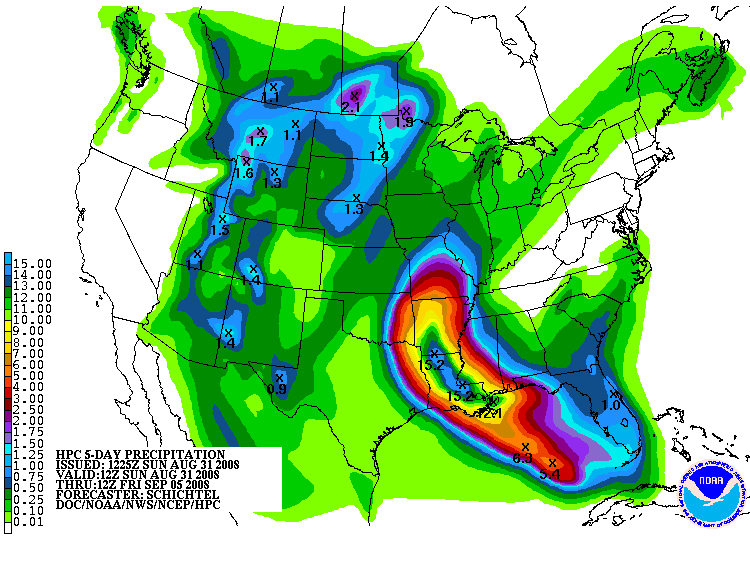
HPC 5 day rainfall estimates (12z 8/31)
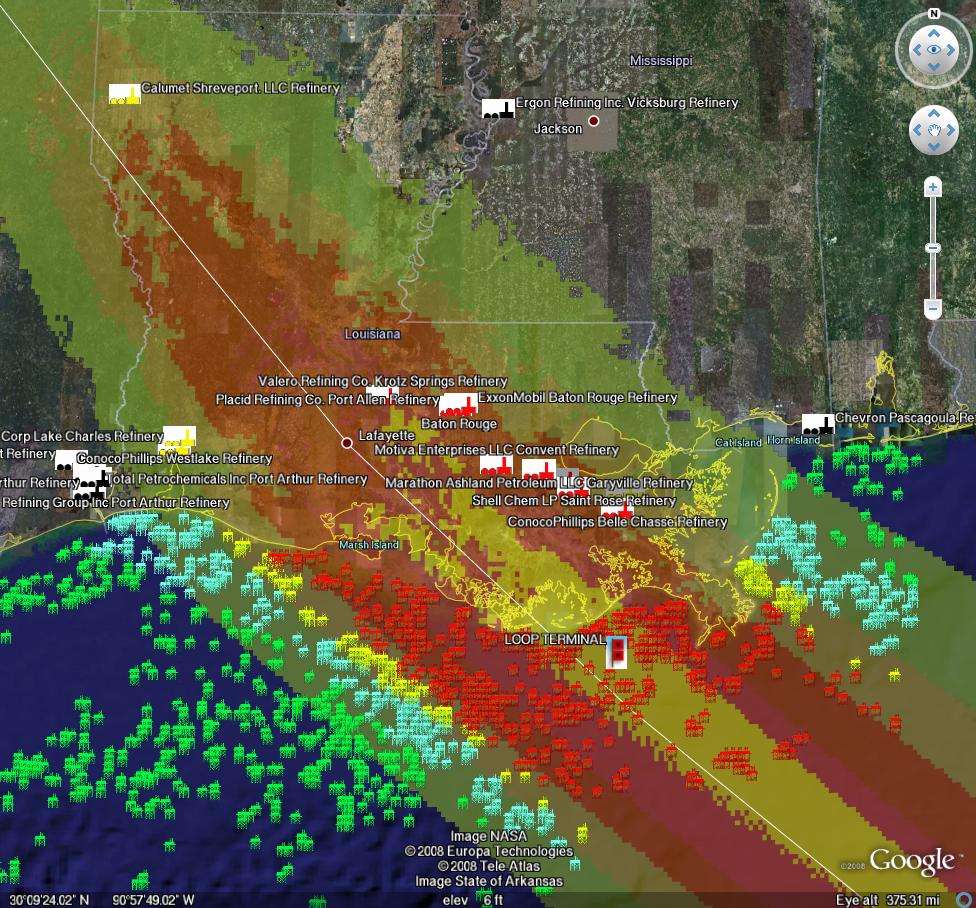
PRODUCTION/INFRASTRUCTURE MAPS AND REFINERY INFORMATION
Here's a link to a really good map of oil refining/SPR storage facilities in respect to the path of Katrina (NB: OLD TRACK MAP!) and here is a listing of production and refining capability for the state of LA.
Just to give you a rough idea of where things are, the map above is a probability swath for Katrina (OLD TRACK MAP!) with the Thunder Horse platform as the red dot, and the other purple dot represents the Mad Dog development (100,000 bd); the Holstein development that produces at peak, around 100,000 bd of oil; and the Atlantis field that may have ramped up to around 200,000 bd in all. Put together these projects have the potential of around 650,000 bd, but as can be seen, they were sitting in an uncomfortable spot relative to the track of the Katrina.The white dot is where Port Fourchon is. This is where the Louisiana Offshore Oil Port, or LOOP, is located. Rigzone pointed out that this is where the foreign tankers offload, Google and Terraserve maps you can see that the area is very low-lying. One of the big concerns is that there will be sub-sea landslides or other ground movement that might affect the LOOP. Were this to be disrupted, then foreign tankers would need to be diverted elsewhere, with the likely port being Houston.
We have accumulated resources from previous hurricans below, but we'd like to find updated materials if you know of them. Recent refinery maps, recent rig maps in the gulf, recent gas fields, SPR facilities, the Intercoastal Canal, pipeline stations and transfer points, etc., etc. Leave links in the comments please.
Also, here's the EIA's Alabama, Louisiana, Mississippi, and Texas Resources pages. They will also likely come in handy. Also, here's a link to the national page.
Here's another good resource for infrastructure maps and such. (scroll down a bit)
Here's a map from CNN with large and small refineries laid out. (though it is an old storm track)
Very detailed piece by RIGZONE on rigs and other infrastructure in the area. (thanks mw)
Here's a flash graphic of the oil refineries and rig maps from Hurricane Rita, it emphasizes Beaumont and Galveston's importance. Click on oil production in the tab. Note the many rigs on the east side of the storm that will get the brunt of the damage from the NE quad of the storm...hence the high long-term GOMEX oil production damage estimates below.
Here's a link to Rigzone's coverage of Gustav.
You want a detailed map? Well here's the probably the best MMS map I could find. Very detailed and lots of interesting stuff. (VERY big .pdf warning)
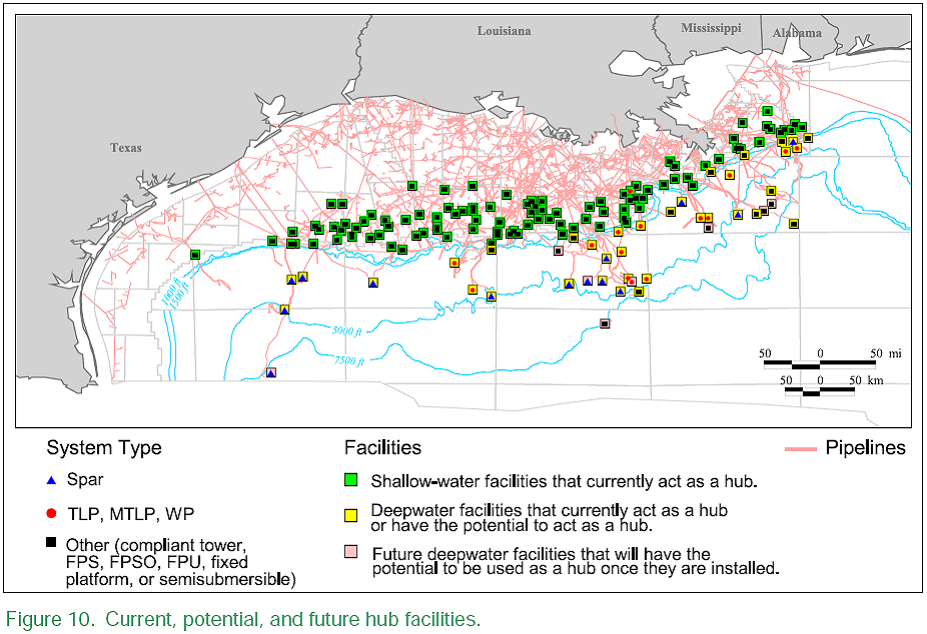
Also, Scott Wilmoth at Simmons & Co was kind enough to send us this map. The map below captures only deepwater infrastructure. For a complete list of deepwater development systems (includes operator, depth, location): http://www.gomr.mms.gov/homepg/offshore/deepwatr/dpstruct.html
(Please deposit new relevant links, graphs, and comments in this new thread...we have updated the resources part of this post with new maps and some more old maps and articles from Katrina on the LOOP and Port Fourchon--important parts of the infrastructure, as we learned about three years ago. Please leave personal anecdotes and themes unrelated to hurricane for the other upcoming 'bigger picture' posts, as yesterdays information was difficult to upload for those on dial-up)
Hurricane Gustav, Energy Infrastructure and Updated Damage Models -- Thread #4 (Updated 8/31 23:00 EDT)
PDF version
255 comments
Hurricane Gustav, Energy Infrastructure and Updated Damage Models -- Thread #4 (Updated 8/31 23:00 EDT)
PDF version
255 comments
Contact
- Content: editors at theoildrum dot com
- Tech support: support at theoildrum dot com
License

This work is licensed under a Creative Commons Attribution-Share Alike 3.0 United States License.
Don't relax just yet. Gustav's interaction with the Cuban land mass took some of the steam out of the storm. It could quite likely rebuild before making landfall and arrive with the same or even greater intensity than Katrina, and unlike Katrina in a more target dense area.
Under the current model I envision outer bands blowing into the mouth of the river (from the east) prior to the passing of the hurricane, effectively raising the level of water, (hence blocking the way for relief), then the eye passes over the city or just upstream from it and dumps much more water which will have nowhere to go.
I don't wish to see something like this happen, but it does look possible, if not probable.
If you're in New Orleans, leave. Now.
Have been reading this site daily for over a year, just now making first comment.
Gustav may leave a more memorable impact on the U.S. than did Katrina. Should Gustav reach its full potential of inflicting destruction on the energy infrastructure of the gulf region, the entire nation would feel immediate economic after-shocks that Katrina could have never delivered in her time.
It's starting to look like this could be worse than Katrina in every way. It's currently forecast to hit NOLA in a worse spot and angle. It's more powerful, and some meteorologists say it will be bigger. (Most thought that was extremely unlikely before last night.)
I suppose the bright side is that we're better prepared. The evacuations are going more smoothly, and presumably the oil infrastructure is hardened.
But our reserves are depleted now. We have less inventory. And as Gail has pointed out, our financial system is less able to withstand this kind of blow. It won't be able to offer mortgage holidays and loans like it did last time. The government will no doubt step in...but they're not exactly in great shape financially, either.
Looking at the bigger picture, ATinNM looks at the cycle of destruction and debt created by hurricanes in the poorer Caribbean nations. Let's not forget Gustav is not striking only the USA.
Here's an excerpt:
500 years and the Europeans are counting down to the last days.
One wonders how the Arawak made it for thousands of years.
Jerome...you hit on something we haven't much discussed here with Gustav. We are in a worse situation financial situation now than when Katrina hit. The ability to finance the rebuilding in the wake of Gustav is going to be much more difficult now that credit is harder to come by (personal, commercial, municipal, etc.).
Some are not going to rebuild I think due to the new stipulations on loan terms or people/companies may just find out that they won't qualify for new loans.
The big petro companies will rebuild, but that will slice into profits more and more.
It's ironic that the hit will be taken by some of the disaster-capitalist vultures who swept up the pieces after Katrina, buying up what they thought was prime real estate.
http://www.powells.com/biblio/18-9780805079838-0
"People still reeling from catastrophe were being hit again, this time with economic 'shock treatment,' losing their land and homes to rapid-fire corporate makeovers."
Whatever we do, we must make sure we do it with borrowed money.
You talk about the economy affecting the reconstruction. What about the other way, what effect might have the hurricane on the already weakened economy, or it may be the first piece to start the domino fall.
Also, insurance coverage is different (lesser) than what it was when Katrina hit. Insurance companies realized how much they could lose if a big storm hit, and how difficult it was to tell wind from water damage. According to Insurance may not cover as much under Gustav, deductibles of 2% to 5% of the home value are now mandatory. When Katrina hit, deductibles were much smaller.
Also many policies have a wind exclusion. (The always did have a water exclusion.) If people with the wind exclusion want wind coverage, they can only buy it from the state-sponsored insurer, Louisiana Citizens Property Insurance Corporation. Coverage from Citizens is only on a depreciated value basis, and does not include additional living expenses.
With the lesser insurance coverage available, people will have to dig more deeply into their own pockets to pay for damages. This is almost certain to have indirect financial impacts. People are already having difficulty paying their mortgages. With all of the payments required under deductibles, and the possibility of being without a job and having no coverage for additional living expenses, even more folks will default on mortgages. This will make the plight of banks in the area even worse than they were before.
Long term, the prospect of multiple hurricanes hitting the area with little insurance coverage available would seem likely to depress real estate values. Thus, even homeowners who can make it through the immediate problems are likely to experience a loss when they sell their home. This will have a further adverse impact on banks.
I am a network admin for an insurance defense law firm in Mississippi which handled a large part of our state’s Katrina related insurance defense. People, often rightfully, get emotional about the way the large insurance concerns handle the aftermath of a massive disaster. It’s a numbers game for the insurers, and they are obviously in the business to make a profit. What I’ve found fascinating is the whole Scruggs debacle with severe corruption on the defense side of a large class action legal battle. When people are suffering, everyone wants to see aid (in this case, reconstruction aid) delivered as quickly as possible. However, the Scruggs incident shows exactly what the insurance companies fear and why much of the legal wrangling takes so long. Scruggs represented a large number of innocent clients, and their interests were severely hurt due to bad representation.
The chaos following a major natural disaster is rife for corruption. It attracts unscrupulous elements of all sorts, and we witnessed the misuse and sometimes embezzlement of government funds in the devastation following Katrina. For right or wrong, we will see the process of insurance settlements take a period of years in many cases. The government’s ability to provide large scale infrastructure renewal is very limited in the short term, too.
Many in the nation object to footing the tax bill for bailing out people who intentionally rebuild in disaster-prone areas. Some called for NOLA to be abandoned. If the storms are becoming more frequent, and if our coastal cities are subjected to cycles of destruction more often than every 10 or 20 years; I believe our system will passively cause the abandonment of high risk areas like New Orleans. Congress won’t vote to abandon or relocate NOLA until long after it has been effectively abandoned by our reconstruction processes working on a slower cyclical scale than the storms do. With 20 year (I don’t have exact figures at hand) cycles of destruction on the Mississippi Gulf Coast, the system functioned to rebuild the diverse interests. With 10 or even 5 years cycles of destruction, many elements of society won’t have the opportunity to exist in the high risk areas.
I would mark this post up 10 times if the software allowed.
Best wishes for eliminating 100% of the fraud in NOLA.
And what of the fraud in Iraq? What of the fraud getting us into Iraq? The frauds constantly committed BY the insurance companies with unscrupulous practices?
What of the fraud committed by abandoning insureds because they actually use the insurance?
Shush...
Cheers
But this seems beneficial to the rest of us as people will tend not to try to live where they ought not try to live.
When Uncle Sam chips in to pay for storm damage of people who live near rivers and coasts this amounts to more prudent people paying for the decisions of less prudent people. I hate it when that happens. The less of it the better.
"Let's not forget Gustav is not striking only the USA."
Thank you for that Jerome.
Its my one and only complaints about TOD is the fact that the discussions get too academic at times treating humanity as an afterthought.
Its not bad enough that I will demand my money back though ;-}
Pre-Katrina New Orleans provides numerous usefull comparisons to the greater U.S. economy of 2005. Many parts were ugly and decaying, but the shiny facade was intact and attractive... and the party beads were flying.
Today - with the asset-evaporated, credit-curdled, economic climate forcing the U.S. Treasury's sawing of load-bearing walls to open more "auction windows" - the U.S. economy has been layed bare of it's Bourbon Street.
Gustav itself - for all it's destructive bluster - might come to be known as the calm before the storm.
From all angles, we're in a precarious situation here.
Yep, the word on the street is that the Chinese are closing their discount window. Socialism works great until the lending stops. The time comes when we actually have to produce something someone will pay for -- other than paper.
First of all, NHC doesn't show much strengthening because of drier air aloft:
http://www.nhc.noaa.gov/text/refresh/MIATCDAT2+shtml/311457.shtml
Katrina at this point was a category 5 hurricane, which mainly meant that it collected cubic miles of sea water which was the storm's powerful surge. This surge washed out infrastructure - Gulfport's casinos, Murphy Oil's refinery piping, New Orleans' floodwalls - even though the hurricane itself had moderated to a cat 3 at landfall.
Keep in mind, much of the Gulf infrastructure has been replaced/upgraded since Katrina. Properties in New Orleans have had rotten trees removed, doors and windows strengthened and roofs replaced; weak structures demolished and flood walls repaired. The drainage canals that allowed the surge to inundate the city have been sealed off and a new pumping system installed. Much of the petro infrastructure damaged by Katrina has been replaced in the meantime.
Hurricane Rita was another cat 5 storm that followed a similar track to Katrina that did little additional damage to the New Orleans. Damage was limited to the Texas and western Louisiana coast, where structures were either very close to the water or poorly designed and constructed.
The petro industry designs for storms in Louisiana, like they design for earthquakes in southern California. A big problem is the age of equipment:
http://www.simmonsco-intl.com/files/OTC%202008.pdf
The new stuff should hold up just fine in this particular storm ... and Hew Orleans, too!
Unfortunately, the long range forecast (not too accurate, however) has Hanna entering the Gulf via the Florida Straights by the middle of the week:
http://www.hpc.ncep.noaa.gov/medr/9mh.gif
Recently, storms that enter the gulf via the Straights tend to turn into cat 5's.
Keep in mind, much of the Gulf infrastructure has been replaced/upgraded since Katrina.
This is part of why I think this won't be as bad as Katrina. The storm itself may be, and it may cause worse damage. But other things combined to make Katrina stand out. I mean, we have had really bad hurricanes in recent years, but no other hurricane has had that level of fatalities since the early 1900's.
I'm sure that procedures have been tightened, and that any number of identified problems have been well documented, action plans written, etc.
But do you honestly think that since 2005 there has been massive investment in actual physical infrastructure? And if so, obviously depending on the storm itself, do you think that this newly improved infrastructure will be able to withstand it?
Personally, I bet this storm is likely to reveal just how much wasn't repaired/improved after Katrina/Rita. Maybe we won't find out, which will be a blessing for many.
I have actually commented a few times that another direct hit by a major storm within just a few years of Katrina might be the end of New Orleans as a major city. But the kind of death toll that Katrina caused is a very rare occurence. The levees were a major identified concern prior to Katrina. In fact, I did think Katrina was going to be pretty bad, and commented to my wife before it hit that it may very well wipe out New Orleans. But the worst of the levees have been patched up, and people are heeding the call to evacuate.
I am not downplaying the storm, just saying that Katrinas are exceedingly rare.
Depends ... I've been to New Orleans several times before and after Katrina/Rita (My brother owns a house there). People in New Orleans with means can afford insurance. Insurance allowed home and business owners to not only repair direct damage but to make improvements. The structures of people with means tended to be stronger and better located, above sea level, for instance. The wealthy neighborhoods did not flood nor did they sustain much in the way of wind damage. More damage was done by fires that were difficult fo fight because of no pressure in hydrants or fire department out of service.
Persons without means or in neighborhoods that were well below sea level such as Lakewood in NO or in ares east of the city such as St. Bernard Parish, were wiped out. The cheaper, newer suburban- style structures were ruined. Infrastructure improvement here would be limited to replacement, in that light, any infrastructure replaced may or may not be sturdy enough to withstand a storm.
The repairs to the industrial infrastructure have been substantial, where essential. New Orleans area industrial infrastructure is massive; oil terminals, piers, refineries, chemical plants, power stations, pipelined, railroads, canals and locks, warehouses ... because of a built-in redundancy, much of these facilities were ready to operate in a short period of time after Katrina. Nevertheless, there were large problems with pipelines and electric power availability. Large areas of south La and Mississippi were without power for months. This included refineries. Storm currents damaged pipelines under shallow water that took a long time to repair. Like the flood walls, the repaired sections are as good as new and should withstand anything other than the direct hit of the most powerful storm.
As for the older sections adjacent to the repaired sections? ???? ;)
I think its fair to say that the older, shallower platforms and support structures are in poor condition due to neglect. Many of these items are at the end of their service lives and it would be uneconomical to improve them. I cannot judge whether this is wise ... Other facilities, such as the refinery at Chalmette, which received a direct hit from Katrina is very much in service and has been - as far as I can tell - been the subject of continuous improvement. Power must still be supplied to the plant and fuel to process, obviously.
In my opinion, the problem with repair to the city and it's support structures is more a matter of concept than investment. the MRGO canal is still ready to direct trillions of gallons of ocean water into the heart of New Orleans and St. Bernard parish. There has been more than enough time to remove the shippers who use that canal and close it. The basic design approach hasn't really changed since the 19th century; to fight the water rather than accomodate it. The fight approach is familiar, but it is expensive and requires the entire area to be equally defended; any leak or rupture anywhere can inundate the whole. The approach is ignorant, in my opinion; water has been in the southern gulf for millenia and to predend it can be kept out at all times is delusional.
Part of this has to do with the 'dialog' between the 'environmentalists' and the business people who run things. That's a characteristic of the 'peak oil' problem, isn't it? Denial...
1:40 AM from Nationl Hurricane Center;
It seems as if Gustav will be a moderate hurricane. There should be minimal damage.
It also appears Hanna is going to turn to the north parallel to the Florida east coast and make landfall on the Georgia-South Carolina border.
http://www.nhc.noaa.gov/refresh/graphics_at3+shtml/025514.shtml?5day#con...
That is really out of date now. It's dated 11pm and the data it's based on is older than that. Gustav has strengthened and organized a lot since then. There's good eye, and it's shrinking quickly. (Not a good thing.)
And the track is east of the predicted. Any wobble now can make a big difference in where it comes ashore, but at the moment, it's looking a lot worse for New Orleans than it did when that forecast came out.
And another update just came out. Gustav is slowing quite a bit. Which could help it intensify.
And it really is east of where it was predicted to be.
Dear Leanan,
where do you get your latest data from?
See my blog. URL is in my profile. I put all the links I am following there. :-)
The high points...the NHC just came out with another update. And CNN is doing wall-to-wall coverage.
Been there, done that. Thx.
Here's a radar image.
Radar has been where it's at for the last couple of hours, because the satellite was in eclipse. Satellite is just getting back now.
You have some great links there. Especially the forums. Really appreciated.
thanks for the links via your blog. that easternuswx forum is hopping -- several posts/minute.
What I think is really of interest is that both of them are the same size at roughly the same spot in the Gulf. The last tracking point for Gustav is 86W 24.5N and Cat-3. The similar tracking point for Katrina was also Cat 3. I compared the archived Katrina track on Weather Underground to the one for Gustav. The difference with Gustav though is that it became a Cat 4 before making it's first landfall, Katrina was only Cat 1 when it passed over the tip of Florida. I don't know if that means anything or not but for comparison purposes, this one was much bigger sooner.
That's a useful comment! Are you sure about this ?!?
Yes I am positive, here are the pictures.
My God, the Gustav tropical storm path prediction goes up the Mississippi, right into the region that got flooded last month.
Also, look at the sea surface temperatures in the gulf of mexico. They're up, which means stronger hurricanes. It's about 30C which was about what it was before Katrina.
Gustav May Hit Gulf Platforms Harder Than Katrina
Most gulf oil pumps shut down ahead of Gustav
Gas pumps running dry in New Orleans; oil companies close refineries, rigs
And here's Shannymara's new link. It's a map of the Gulf Coast, with oil infrastructure, dynamically updated every 10 minutes with weather radar, Gustav track, etc. The darker squares are newer rigs. Only active rigs are shown.
"It's a case of a large number of people making a big, unexpected rush to service stations."
What did you expect then? That has to be one of the dumbest things I've heard in a while.
As I noted yesterday, nationwide we had about 60 hours of gasoline supply in excess of Minimum Operating Level (MOL). With refineries shutting down, with people rushing to fill up their cars and with consumption in the Gulf Coast area way up as millions of people move inland, shortages are inevitable.
I couldn't agree more. Look at the list of impacted refineries and GOM production in the Kinetic Analysis top of these threads.
If this is the case, if we drop below MOL for a significant (more than 60 hour) length of time, is there any way of predicting which areas will be affected? Someone said that the Western part of the US would be ok (since their pipelines come from the west coast?). Any maps or stats on what this would do to other regions? I assume the southeast would be the worst affected, as it was after Katrina. Besides that, any specific predictions/guesses?
We look to you, o intrepid Oil Drum experts, to sound the alarm... :)
The problem is that sounding the alarm for 'this week' is actually counterproductive. What will happen will happen. We (and others such as ASPO, Energy Bulletin, and a handful of outspoken civic leaders) have been trying to articulate for years that it is past time for a seamless transition away from cheap oil, and high level discussions and policy changes need to be top priority to direct our remaining quality fuels towards scaling of renewable infrastructure, and (if possible) changing the conspicuous consumption metric.
The odds are that this storm will not be a catastrophe (Im not an expert, its just that the odds are that EACH storm will not be a catastrophe). But over time, those small odds add up, and with a stretched (financially, energetically, and socially) system, the straw that breaks the camels back will always be one event away.
Have you ever noticed that when gasoline supplies get tight, it's always North and South Dakota that report the first station closings? Leanan says it's because they're at the end of the pipeline.
It is not that Leanan "says," it is because they are at the end of the pipeline.
Why would that matter? All the nodes on the pipeline are bidding for product. Why sell it all for a lower price at an earlier point on the pipeline?
Just a quick street-level anecdotal report: Here in coastal Maine the gas stations have been packed since opening this morning. Folks figure the price is bound to rise post-Gustav. My neighbors on both sides and behind me filled up all their vehicles and spare gas cans with $3.61 gasoline. Several gas stations already have bags over some of their pump handles.
I think that really says something since this is the weekend as well.
It is only a shortage of gasoline if you arrive at the gas station and there is no gas left and you have no gas in your tank. Since you are then screwed and must stay in New Orleans you can comfort yourself by noting that the rush to the gas stations was unexpected and there really is no shortage. Your family, if any left, can put that on your grave stone.
That sounds grim and doomerish, which is saying something coming from me :-)
Per Alan Drake's report yesterday evacuations are running smoothly and if there are stations that run short the refills are happening within an hour or two - plenty of local supply available for the dash out of the gulf region.
This won't be a bodies floating in New Orleans repeat of Katrina, this is something new ... and it's going to affect all of us if the predictions come to pass.
Yes, it sounds like they were prepared for the fuel issues this time. Jeff Lindner, a Houston meteorologist, has been reporting on the fuel situation:
I wonder how that will affect supplies in the rest of the country, though.
Watch the Colonial, TEPPCO, Plantation, I believe. The experts
can do better with the rest.
Pipeline & Gas Journal, Nov, 2004
24th Annual 500
100 Leading Liquids Pipelines
Barrels Delivered Out of
Rank System In 2003 (000)
03 02 Name of Company Total Crude Oil Products
1 2 Shell Pipeline Company 1,221,253 814,565 406,688
LP
2 2 Marathon Ashland Pipe 879,504 530,045 349,459
Line LLC
3 3 Colonial Pipeline Co. 836,607 0 836,607
4 4 Exxon/Mobil Pipeline 651,103 431,730 219,373
Co.
5 6 Enbridge Energy, Ltd 525,572 525,572 0
Partnership
6 5 LOOP LLC 510,089 510,089 0
7 8 SFPP, LP 409,203 0 409,203
8 9 LOCAP Inc. 407,168 407,168 0
9 7 BP Pipelines North 382,244 228,466 153,778
America
10 11 Alyeska Pipeline 362,554 362,554 0
Service Co.
11 10 Sunoco Pipeline LP 355,909 144,695 211,214
12 12 Mobil Pipe Line Co. 350,198 222,980 127,218
13 15 Conoco Pipe Line Co. 338,626 233,356 105,270
14 16 Buckeye Pipe Line Co. 336,737 0 336,737
LP
15 13 Chevron Pipe Line Co. 301,189 244,251 56,938
16 26 Plains Pipeline LP 298,293 298,293 0
17 17 Tosco Distribution 244,122 105,156 138,966
Corp.
18 14 Mid-America Pipeline 242,003 0 242,003
Co.
19 18 Magellan Pipeline Co., 237,629 0 237,629
LLC
20 24 TE Prod Pipeline Co. 229,693 0 229,693
LP (TEPPCO)
21 19 Plantation Pipe Line 223,545 0 223,545
Co.
22 20 Teppco Crude Pipeline 214,299 214,299 0
LP
23 22 Oiltanking Houston 202,019 100,620 101,399
Inc.
24 21 Explorer Pipeline Co. 196,439 0 196,439
25 29 West Shore Pipeline 166,304 29,218 137,086
Co.
I haven't noticed the gas prices coming up this weekend in Atlanta yet. During Katrina gasoline wasn't available at many gas stations for a few days and this was also were we saw the anomalously high fuel prices:
maybe it's only a short-term dilemma that gas stations don't have enough numeral 4's...
maybe the problem is that there's only one digit to the left of the decimal?
This scenario, of difficulty evacuating an overshot population away from the coast quickly in the face of tight gasoline supplies and limited exit strategies, is the crux of the overshoot problem. All of a sudden systems that operated smoothly and viable reactions to crisis become inoperable. Tight supplies lead to chain reaction problems with shortages elsewhere and further stress on the economic system (Insurance, anyone?) in a cascade. The stupidity of repopulating NO after Katrina will become clear after this. We had three days to evacuate a reduced population of this city, and it was still a herculean task.
We will see this scenario play out over and over from here on out as things get tighter all around.
The floating bodies this time will be mainly white Suburbanites.
The central part of New Orleans (aka not Algiers (West Bank, escaped last time, not Lower 9th, not New Orleans East) is at relatively low risk of levees breaking. Rainwater flooding a risk, but fast movement (17 mph) will limit that.
Coastal towns wiped out, West Bank (especially east of Harvey Canal) at severe risk. North Shore at risk for 2 days of xx feet storm surge (xx depends on complex models of speed and strnegth and diameter and EXACT path, but pretty bad to worse).
Most at risk areas have "apparently" lower rates of evac (hard to judge ATM, just indicators. North Shore NEVER expected to evacuate, so a shock to them.
Asymmetric hurricane due to ingestion of dry air on "right front side". Normally strongest point is weakest. Unsure if this will continue to landfall.
Cat 2 or Cat 3 now. Some dispute due to asymmettric nature of Gustav.
Finished packing, taking a nap. Out mid-afternoon, roads close time around dawn Monday.
Best Hopes,
Alan
The death toll from Katrina was evenly spread out into the upper class neighborhoods as well.
The difference being that the police didn't shoot or block any of the upper class neighborhood inhabitants, if news reports are to be believed.
Because they were not in the process of looting, pillaging or raping.
This time even Nagin has broadcast that anyone caught in these acts is going directly to general population in Algiers.
Musashi, I love it. Someone actually willing to say something truthful, though not PC, gets negative ratings. Unfortunately we are all going to have to begin to face the truth, not wishful thinking.
Just some perspective.
Here are some pictures and captions from the AP (via Yahoo) in the aftermath of Katrina. I've just linked the jpg's because they are fairly large (260KB ish).
Looting:
A young [black] man walks through chest deep floodwater after looting a grocery store in New Orleans
vs
Finding:
Two [white] residents wade through chest-deep water after finding bread and soda from a local grocery store after Hurricane Katrina came through the area in New Orleans
Anyhoo.
Shocking and Depressing
To be fair, one is AP, one is AFP. IME, there's a big difference between those two news services. AP has a more American outlook, AFP more European.
Like those looting, pillaging, or raping tourists -
'Frightened Japanese, European and American tourists say police fired over their heads to end their attempt to leave New Orleans.
Stranded since Hurricane Katrina hit the city on Monday, the 200 tourists were thrown out of their hotel on Thursday morning and said they were confronted by police as they attempted to get to buses to take them to safety.'
http://www.abc.net.au/news/newsitems/200509/s1452073.htm
There is also a Fox link of the incident - http://www.foxnews.com/story/0,2933,168270,00.html - for those that prefer their news presented in the correct fashion.
Somehow, I doubt it. It's always the poor that suffer.
CNN is reporting that the homeless population has exploded in New Orleans. The local homeless outreach group says many of them are trying to ride out the storm in New Orleans. By holing up in vacant properties that survived Katrina. They think that since those homes weren't flooded by Katrina, they'll be safe this time.
And I suspect it's not the suburbanites who can't afford to evacuate.
In fairness, the suggestion from Alan was that the storm track looked probable to hit areas where the inhabitants consider themselves to be utterly safe, and thus many of them would not leave.
Of course, the storm might not track as predicted yesterday, but his point was based on large number of comparably well off individuals who would remain directly in the path of a hurricane.
That includes Alan himself, it would seem. :-(
You can see the front part of the eyewall now on Shanny's map. It looks like it's going to pass right over New Orleans.
Alan planned to weather the storm in Hatteisburg, MS. He intends to return to NOLA tomorrow if the damage isn't too major.
In the end he didn't go anywhere...
The suggestion from Alan implied that the poor areas of N.O. suffered a disproportionate number of deaths and that people of means evacuated.
Actually most of the deaths occured in the elderly.
http://www.wkrg.com/hurricane/article/new_report_released_on_hurricane_k...
"Ewe's not fat. Ewe's fluffy!"
And of course this comes at a time when the EU is meeting to discuss the reaction to Russia's activities in Georgia, with the backdrop of the (likely) Russian whisper-campaign about the possibility of cutting off some of the EU's gas as part of their cudgel diplomacy. The sooner housing is made net carbon neutral, the better. Time to acquire solar hot water, and even a solar oven.
What do you expect, hypocrite. NATO sponsors war criminal Saakashvili and defends his barbaric attack on civilians (NOT collateral damage, but deliberate targeting with mass extermination weaponry)
and Russia is supposed smile and say what a bunch of humanitarians you are. NATO is threatening sanctions and it should expect fully justified retaliation.
Tussle on the Drumbeat, guys.
Hopefully the OSCE report that's supposed to be out tomorrow will take some of the wind out of the sails of the "punish Russia" types, at least in Europe. I don't expect it to have much effect in the US.
While I agree that, in my incomplete view, the Russian govenment has acted civilized and the US government barbaric in Georgia, why "Diss" Will? He didn't even comment directly on any of this he just said we need hot water heaters ... The Villain!!! There's enough violence and dissension in the world already, keep your ripostes on target.
This is a graph that was posted by ace on thread 2, showing historical oil US oil production in the Gulf of Mexico, and his forecast of future oil production in the Gulf of Mexico. The US total crude oil production is about 5 million barrels a day, so production from the Gulf is about 28% of that total. Some production was offline for several months after Hurricane Katrina.
This is a graph Gail made of federal offshore natural gas production in the Gulf of Mexico. State offshore natural gas production is not available monthly, but it isn't very much. Adding Texas and Louisiana state offshore natural gas would only increase the total by about 5%. Gulf of Mexico natural gas (federal plus Louisiana and Texas state) currently amounts to about 13% of US natural gas production. When Katrina hit, we lost the equivalent of about one month's natural gas production.
Generic SLOSH forecast for a Cat 4 Hurricane
If I'm reading that right, magenta is 24-28 ft. And that's right at the Bonnet Carre.I can't find whether the Bonnet Carre is open or not. If it's open the surge could...
If it's not...
I'm expecting Petro Chemical Alley to be underwater at 16 ft.
Unless an expert tells me otherwise.
Get ready for a shortage of plastic sacks.
Besides praying for those in the path and under evacuation, I find myself mulling over what a severe hit on New Orleans will do to the American landscape, as well, of course, as our gas and energy situation. It seems like that among those thousands who did return to New Orleans, if the city is devastated yet again, many will not return this time. The voice of those who said that Katrina was a once-in-a-lifetime event will, I think, be overridden by the reality. How many people can afford to lose homes yet again? How many people can afford to evacuate and rebuild over and over again? How often will the country fund such a rebuild - one we've essentially failed to pay for already?
I doubt the City of New Orleans will cease to exist entirely, but I do fear we may see the continuation of its erasure as a major city - the first but not last such city.
Bill Mollison apparently suggested that one of the great works of permaculture should be the relocation of our coastal cities - I don't think we're ready to begin that work, but I wonder, if Gustav and Hanna and their posterity are sufficiently dire, whether this might not force our hands and our consciousnesses.
Sharon
It's not only gas and oil. New Orleans is a major port. Oh how quickly we forget the coffee, sugar shortages after Katrina. The inability to ship grain from the heartland.
I heard someone say cognitive dissonance on another thread. Sounds about right.
She didn't say New Orleans would vanish entirely.
It's a port, but it needn't be a major city, and was fading even before Katrina. And it's a port because of massive government effort, which may not be possible for long in the post-carbon age.
Didn't direct the cognitive dissonance part at her.
New Orleans' fate was decided long ago.
Read Rising Tide.
You can have a deep sea port or you can have a protected ciy, but not both (the plan instituted to clear and deepen the ship channel destroyed the barriers in the gulf that protected the city).
That's the problem, Leanan. NO cannot vanish. It's the most strategic city in the US.
But it can't stay where it is, either.
NO, or whatever, wherever south of the Old River Control Project will have to be major enough to supply roughly the Louisiana Purchase Territory.
I say Baton Rouge or Lafayette are the next NO's. There's no other way unless everything is built right on the MS River levee. From a NO Saints Sportsblog (and why do the fishing/boating mags and the sports blogs have the best info on offshore energy and local land conditions?:
"I talked to a police officer next door who said yesterday, before the models even shifted eastward, that they were planning for at least 6 ft across the west bank.
http://saintsreport.com/forums/showthread.php?t=80139&page=61
EDIT:All those concerns, and I haven't even mentioned the stupidity and hardheadedness of my family members from the coast who think going to Donaldsonville and Lafayette is evacuating.
http://saveourwetlands.org/cansaveno.html
"But the 1973 flood surfaced another unhappy fact. We had given nature its space, but we were now taking it away. The Atchafalaya floodway remained privately owned and people were beginning to settle in with towns, schools, churches, the whole nine yards.42 As the Mississippi waters raged down on Louisiana in the spring of ‘73, dangerously high and still rising, the Corps faced the unenviable choice of whether to open up the full floodway and drown these towns—shades of Plaquemines and St. Barnard—or to open only a part of the floodway below them and hope for the best.43 The Corps opened part, hoped, and lucked out. At which point, blinders-on, the Corps marched forward with a channel project that would dry up the floodway and invite wall-to-wall development along the entire length of the Lower Atchafalaya from guide levee to guide levee, fifteen miles wide and sixty miles long.44 I remember a New Orleans District official telling me at the time, stars in his eyes, “Oliver, this is going to be another Ruhr Valley!”45 I said I couldn’t wait for him to pull the plug on all that new investment the next time the Mississippi rose."
Or a 24 ft storm surge came up out of the GOM.
What will this new city be built with? Mud and banana leaves?
Halliburton, Blackwater and as much of your tax money as they can steal.
We need a port on the Mississippi. It is no accident that New Orleans is one of the oldest cities in the US. It is in about the best location possible for a port. On the other hand, as various people have pointed out, you don't need a major city to have a port.
IMO, there will be a port there, no matter how many times we have to rebuild it, at least until sea level rise obsoletes it. Whether a lot of people live there is another question.
This really is easy: go ahead and dig it all out up to Baton Rouge. Relocate the most historic stuff up there so they are sister cities. That's where 5 meters of sea level is going to take you anyway... the train tacks are pretty easy to move compared to some other infrastructure, I'd wager.
Just get ahead of the wave. So to speak.
Cheers
Or until the river decides to move on, as it does regularly.
"One who knows the Mississippi will promptly aver...that ten thousand River Commissions, with the mines of the world at their back, cannot tame the lawless stream, cannot curb it or confine it, cannot say to it Go here or Go there, and make it obey; cannot save a shore that it has sentenced." - Mark Twain
Rebuilding commercial infrastructure is a investment and business decision.
People needed to operate infrastructure an be ferried in and out as on the oil rigs.
Allowing general population in certain locales for the single purpose of permanently living off the gravy train can be qualified by putting the full burden on those choosing to live there, with no possibility of recourse.
Anyone living in the suburbs is living off the gravy train of tax-supported US military forces defending the pro-US parts of the oil industry around the world. Of course with US troops in 130 countries it's hard to tell which ones are where for what reason. But I guarantee you we will not abandon the suburbs until many subsidy schemes have collapsed.
Suburbs allow for a high octane mix of non-renewable and renewable energies, resulting in a higher standard of living (per Odum). The one thing Kunstler misses in his rants is that removal of some of the non-renewables from the mix still leaves a semi-functional system. Post-peak-oil migrations to urban centers are not pre-ordained and will be limited by issues of crowding and catastrophes like these hurricanes. The End of Suburbia is not as clear-cut as he would make it.
If you spent half as much time doing productive work as typing psychobabble you would have enough resources as to not feel oppressed.
Without the taxes the productive people pay, no matter how reluctantly, the welfare leeches you speak for would starve.
Wait and see what happens when enough productive people and capital leave the US, I expect you will have the Zimbabwe you dream of.
But, but, but - just about all the American media is universal in its belief that the world's most talented and productive people are always coming to America. Like all those Chinese and Indian engineers, since Americans are too busy doing productive financial engineering and earning law degrees to protect imaginary property.
As for capital - where is the world supposed to place its savings, unless it is the hands of the productive American consumer? Remember the savings glut, which both Greenspan and Bernanke identified?
Or is it, maybe, just maybe, that the problem isn't 'welfare leeches,' but something a bit deeper down? Maybe America itself is no longer much of a productive society, and the world, however reluctanctly, will stop their support for America's good times?
That's a understatement.
They should stop financing a society that wants a free ride on OPM, and the corporations that want the same at taxpayers expense should be put under with extreme prejudice also.
Plenty of very productive small businesses that can easily self finance. If some idiot in DC wants to put too much of a tax burden on the few left that can make things happen, watch them leave.
I've been thinking along the same lines. I'm more in Greer's camp than yours, but I think we will withdraw from the coasts. Not in any planned way, and not quickly. Rather, after each storm, fewer people and businesses will return, their resources, and the government's, increasingly exhausted.
I don't quite agree, but this disagreement has a few caveats -
a. This is not about the sea level rising 20 feet in the next century. In such a case, decisions in a place like Manhattan are a foregone conclusion
b. The distinction between port and city is quite relevant - in this case, the point is about a city based on the port, not a city which used to be a port. New York City being a fine example of what I am not talking about.
In Europe, a number of major port cities have been kept functional for centuries, as the coast retreated - Hamburg being a fine example. Though the differences between the sea retreating and a coastal region sinking should not be ignored, the advantages of a major river meeting salt water far outweigh even concrete disadvantages - witness Amsterdam's continued existence, for example.
I don't see a retreat from the coasts - what I do see is the rearranging of population. Alexandria is a really interesting example of this - it has thousands of years of history, including some very major ups and downs (largest pre-industrial city that was not the capital of an empire, was one claim, for example) Today, according to wikipedia, 'with a population of 4.1 million, is the second-largest city in Egypt, and is the country's largest seaport, serving about 80% of Egypt's imports and exports.'
When it comes to major cities, the rule is still location, location, location, and where major river meets salt water is still the best way to bet to hit the jackpot. A city based on a port will be at the mouth of the Mississippi for thousands of years, even if there might be centuries of interruptions, as occurred with Alexandria. New Orleans as we know it? Probably not. But then, today's Alexandria has little to do with the Greek city which was the capital of Egypt for a thousand years.
I think 20' in the next century is possible.
And I think we may find, in the post-carbon age, that we no longer have the resources to keep the river pinned where it is. It wants to move west, and in the end, it will win.
I'll give NobodyPanic po.com credit for this one: "nightmare scenario: east coast runs dry on gas just as another large hurricane comes ripping up the carolinas and into virginia. how's that for an ugly thought?"
That would just about do it.
I won't speak for Virginia Beach/Norfolk (which has never been evacuated, to my limited knowledge of people who grew up there) or the Outer Banks, but in Northern Virginia, it wouldn't matter much. This is even more true of the rest of the state.
What would be a disaster is Long Island, Rhode Island, Cape Cod, etc.
I think the good folks over at realclimate.org would strongly disagree with this. That is not to say that anything resembling BAU won't create a climate warm enough that the equilibrium sea level wouldn't be at least 20' higher, but that they don't see a mechanism for the ice to melt that quickly. It looks like although meltwater lubricates the base of glaciers, and allows them to flow quicker, the water quickly drains, so the timescale for destruction of the ice cap will be determined primarily by the time it takes to melt the ice inplace, which is still many centuries.
New report disputes the "many centuries" timescale:
That's 18.4" by 2100. Not even close to 20'.
James Hansen disagrees.
Could he be wrong? Of course. But everyone thought he was nuts when he started talking about global warming 20 years ago, and now it's looking like he was not only right, he was too conservative.
What's happening in real life is much worse than predicted in the models, which suggests we don't understand the problem fully. Hansen thinks the ice melting could go nonlinear in a catastrophic way. I hope he's wrong, but I wouldn't bet on it.
RealClimate are working from their models, which have been consistently wrong on the conservative side. Hansen is speaking from a review of the geologic record and the last time temperatures were this warm AND experienced a rise as large as that expected this century. That was several million years ago but the net results was 25 METERS of rise in roughly 1-2 centuries total.
Collapse of the Laurentide
http://www.sciencedaily.com/releases/2006/03/060312210108.htm
From papers I read on the subject it appears to be exponential, not linear. With the sea level rise roughly doubling every decade. So if it is - say - 1 inch (or 2.54 centimeters) the next decade it could be 256 times that in the last decade of the century -- or more than 5 meters between 2090-2100. And 10 meters in total, knowing the meaning of the exponential function.
In other words: 1 inch may account to nothing in our minds, but in case it IS doubling each decade... that's pretty much a runaway change.
EDIT: Actually, make that 13 meters, as 256 X 2.54 centimeters = 6.5 meters.
In the case of NOLA, there's a pretty good choice of where to go: Flood maps for sea level rises puts Baton Rouge on the beach at 5 meters of sea level. That would put NO back on the coast. They could even plan a port, set aside land, and wait for the water to rise. By the time they get half the city moved there may well be a meter of rise already and a fair indication of how quickly it'll come (assuming we don't get a flip to the cold side from thermohaline slowing/stopping.)
This is something they should do. Save the most historic stuff and create a new city: New Baton Rouge of Orleans! We'll lose Alan, of course, as he's stated he'd become an expat, but the internet should rectify that problem.
;)
My little bro and his partner - unbelievable - just BOUGHT a house after watching something like ten properties get pummeled by Katrina... I wanted to smack him, but hard to do all the way across the big, big water.
Cheers
This is sounding more and more like the story of how Houston replaced Galveston as Texas' greatest port. It took 40 years from the destruction of Galveston to the completion of the Ship Channel. Then Houston went nuts.
The cost of living on sandbars and landfills in hurricane zones is taking a toll on everyone. While individuals may have insurance, the cost of damage to infrastructure is born by everyone. Fires, floods, earthquakes, tornados, hurricanes -- too many of us live a precarious lifestyle that takes no heed to the risks. By socializing losses, we have created this moral hazzard since people take the attitude that someone else will pay the loss. WE WILL REBUILD!! Yes, with OPM, why not.
The old definition of insanity as repeating the same behavior expecting different results. The different result comes when we bankrupt ourselves. The people of N.O. were warned for more than thirty years that what has and will happen, will happen again and again. So, if they enjoy living below water line, fine, just don't ask me to pay for their insanity.
Flood insurance is generally from the federal government.
And people are losing their individual insurance. Home owners in NY and NJ were cut off because of the Florida hurricanes and Katrina, even though they weren't hit. Because the insurance companies suddenly started worrying about hurricanes.
Florida has been forced to offer state insurance for homeowners who can't get coverage. It's going to be a disaster, IMO.
Florida also has some interesting building codes. All new homes in storm surge prone areas must be on stilts, the height of which depends on land elevation or how close they are to the coast. Also, there's some programs where the counties have been offering to pay to put existing houses up on stilts. I don't know anyone who has done it yet though, I think most people don't believe that they would actually do it. That might be connected to what you said about the flood insurance, I'm not sure.
Driving down the delta just after Katrina it was striking how virtually all the houses and other buildings on stilts had survived, since they were out of the water, while those at ground level had been destroyed.
Yea: Don't sell the natives short where ever they may be.
The catch is that the homeowners insurance that is available doesn't cover as much. It tends to have big deductibles (up to 5% of the value of the building). Wind coverage from the Louisiana state-run company provides coverage only on a depreciated value basis, not on a replacement cost basis. Coverage is not available for additional living expense.
If the insurers don't cover the loss, the homeowners are stuck with the loss. I would expect more defaults on mortgages than would otherwise be the case.
replacement cost coverage is a gimmick, imo. if i have a total loss, i can replace my house with the one down the street for a lot less than the cost of suburban construction.
some insurers seem to want to inflate the coverage, and the premiums. a total loss is rare. most of the time, they will want to "repair" any damage. i use the term loosely.
I live in Florida and have one of those subsidized policies which covers next to nothing. If I didn't have a mortgage, I'd happily do without. Pay an outrageous premium for very little.
Yes, flood insurance is subsidized by ALL U.S. taxpayers. I agree with you that the migration away from the dangerous areas -- THE SANDBARS -- will begin now that the national credit card is maxed out. There is no more money to pay the cost of moral hazard.
I like to ponder armchair economics. Here is something that occured to me a few days ago, and it seems relevant to your comments on the national credit card. It seems feasible that the aftermath of the Bush administration will give us cumulative 30% inflation. During the bush terms, the national debt has gone from around $10B to around $15B. Thus, the new debt is approximately 33% of the total. Yet, if the dollar ultimately has lost 1/3 value... Is the value of the new $15B debt not essentially the same value of the old $10B debt? A wash? I know there are other implications, such as the loss of our creditworthiness as a nation. But, isn't this expansion of the money supply the same that ended my grandmother's nickel sodas and dime movie passes? I haven't been able to get my head around the implications of increasing national debt being offset by intentionally inflationary monetary expansion. I do know it amounts to a covert tax on our citizens and our nation's debtors. And I appreciate that TOD may not be the right venue for this coversation.
Current U.S. national debt is about $9.6 trillion, not billion. Public portion of that debt is about $5.7 trillion. Of course, those figures don't include unfunded Social Security, Medicare, etc.; those payments put the total debt at almost $60 trillion. U.S. national debt around time of GWB's debut was $6 trillion or so, so the ratio you noted still holds.
Maybe this is too far from the TOD arena, or at least this thread, but $$ are needed to recover from hurricanes, accelerate development of energy resources, etc., and economy and energy stories are obviously inextricably intertwined (btw, Chris Martenson just finished the peak oil chapters of his Crash Course, with many nods to TOD).
Oops. I did mean trillions. Was heading out of the house and posted hastily. You're right about the current debt being around $10T, and I can't recall what figures that I looked at the other day accounting for higher totals and projecting out some untallied current expenses.
http://www.cedarcomm.com/~stevelm1/usdebt.png
Either way, my question is about debt expanding while inflation eats into the actual value of the debt. I suppose it is a difference between the government spending directly from debt verses the government spending and letting the citizens and global creditors pick up the bill via inflation.
I'm not sure that the actual stated debt value will have much effect on how willing the government is to push subsidies and bailouts, though the slight of hand financing via inflation will have effects on all of us. I expect the government will keep spending as long as they can continue printing bills.
"Of course, those figures don't include unfunded Social Security, Medicare, etc.; those payments put the total debt at almost $60 trillion."
future obligations are not in any way part of any debt.
the only obligations that are part of the debt are owed to trust funds. money that was taken in for one purpose, like social security, and wasted on another, like search for wmds.
and for the record, the debt when bush took over was about 5.3 trillion and is now at 9.6 trillion, an 81 % increase.
My house insurance in California recently went down in cost. It seems the whole state was paying to make good on the loses from the Oakland Hills fire, but now that that has been paid off its back to more reasonable rates.
For the sake of accuracy that should really be ONM: Other Nation's Money.
And if those other nations are faced with refloating Fanny and Freddie, saving Lehman Bros, and a few hundred other banks, and footing the rebuild for NO and region, and putting up with juvenile US foreign policy in Georgia and . .
My hunch is we will see a rise in interest rates post Gustav. Credit will become scarce and you will pay a premium for it.
I'm not a big gold standard freak, but I swear the day that China, Russia and the Arabs bring back Bretton Woods and gold linkage, the US will become non persona grata to all objective businessmen.
Hello TODers,
The US is a huge net importer of many I-NPK products, and much of this needs to go past NOLA, then on up the Mississippi to the farming heartland. If Gustave drastically reduces the ability of these seagoing ships to transfer their loads to the trucking & RR docks and/or the barges going upstream, then we could see serious I-NPK price increases and/or shortages throughout the Central US area [as if the allocation already in place isn't bad enough already].
Aren't our Federal Reserve Banks of I-NPK currently already bulging with huge pre-built stockpiles to add resiliency to our national food security?
No? You mean our JIT inventory system will Never, Ever fail our critical need to grow crops to feed ourselves? Gee, then I guess we have no postPeak worries, no matter how many #'s of hurricanes hammer home, nor how due to ELM: decreasing #'s of crude tankers and I-NPK cargo ships will arrive.
Bob Shaw in Phx,Az Are Humans Smarter than Yeast?
Someone posted in an earlier thread there are 3 100' deep channels going from ocean to Mississipi River and that siltage, debris etc. could make them only 80' deep, which presumably would still be OK for traversing. I don't think anyone is an expert on this though since it's never really happened (and looks unlikely to happen here though I suppose possible)
Hello Nate,
Thxs for responding. It is not so much the navigable river channels, it is more the potential Gustave damage to the critical bidirectional import/export function of seagoing ships<--docks-->barges, RRs, and trucks.
Just as the graphs by Ace & Prof. Goose on this thread show decreasing GoM production due to the sequential hurricane hits to infrastructure: I am similarly trying to build an additional, concurrent case of these 'cane hits eventually decreasing the Mississippi River port process [4-page PDF Warning]:
http://www.waterwayscouncil.org/State%20Profiles/Lousiana.pdf
---------------------------------
The State of Louisiana borders 428 miles of the Mississippi River. This area is a vital segment of the inland waterway system, providing an economic transportation link from the Upper Midwest to the lower Mississippi Valley and the Gulf of Mexico.
In 2005, almost 260 million tons of commodities (mostly coal, petroleum products, chemicals and grain) moved to, from, and within Louisiana. These commodities had a combined value of $107 billion. Petroleum Products comprised 27% of this tonnage, followed by grain at
23%.
There are approximately 773 manufacturing facilities, terminals, and docks on the waterways of Louisiana that shipped and received tonnage in 2005. Five port areas in Louisiana were ranked in the top 15 in the United States in 2005.
------------------------------
Sequential storm destruction, combined with a reduced net energy & funding ability to restore and/or expand these facilities may soon be evident [see my other posts downthread please].
Consider my earlier links where KSA gave Morocco $500 million, and KSA is also moving strongly into Pakistani farmland, obviously, KSA is trying to enhance their postPeak food security function. If the LA port facilities take a heavy hit, will other countries heavily dependent upon USA grain exports ante up to speed port repair if we cannot rebuild at a rate sufficient to resupply their hungry masses?
Same goes for USA I-NPK importation: what level of port damage starts to reduce time dependent JIT resupply for meeting the seasonal planting cycles?
How did we handle this after Katrina?
Anyway, if Gustav goes up the Mississippi and refloods Arkansas, Missouri, Iowa and southern Illinois just after they replanted, fertilizer demand might drop - along with food production. Just hope that we don't get so much fertilizer washed back down the river that the fish in the Gulf all die.
Whoa, this must be what we mean by cascading blowbacks.
Hi everyone. Here's the latest plot of Gustav's intensity, up to 15:00 UTC 31 Aug 2008:
Gustav weakened rapidly while crossing Cuba, followed by a slower reduction in strength even as it moved over the open GOM. Given that the changes, such as increasing central pressure, are now fairly slow, and the hurricane is moving through favorable conditions, I suspect that renewed intensification could begin at any time. As of 09:00 UTC, the NHC is forecasting an increase to 125-knots (~145 mph, ~230 km/h) by 06:00 UTC 01 Sep 2008.
Gustav is accelerating, as indicated in this chart:
The hurricane is now moving at 15-knots (~17 mph, ~28 km/h), in the direction of 320 degrees.
-best,
Wolf in YVR BC
Katrina had a much larger eye than has formed in Gustav. It's cloud cover was more intense. It reached 175 mph rotation. The maximum storm surge was close to 20 feet.
NASA Sat. Photos:
http://www.nasa.gov/vision/earth/lookingatearth/h2005_katrina.html
Within a week of Katrina's landfall on 8/29, Rita made landfall.
Given the state of the global economy, this is looking like the end of global civilization. USA is already on it's knees and if you go down, we all go down. If Gustav hurts as much as Katrina, TKO.
On the bright side, Gus is not looking in great shape and all the warm water's behind him.
Prayers for all the Incarnated.
I share your concern, but 'end of global civilization' is a tad strong. Humans are a resourceful bunch -as long as we have ample energy...
Most likely the withdrawal of private insurance and the increasing inability to socialize the losses will now start to force people out of danger zones. One more major hurricane to hit Florida and the last of the private insurors will all pull out. The state can't possibly subsidize losses or insurance! The bonds of the counties and municipallities just keep piling up and soon they won't be able to make even the interest payments.
The losses and corruption at NOLA will always be socialized. The National Media is already salivating at the opportunity for Photoops from NOLA post Gustav, that they can use to screw the Republican Convention. Bush or McCain will fold and deliver another $200 billion to Landrieu. Only Obama can stop this, since he also has others fighting over that second tranche of $200 billion of OPM.
I didn't say the end of humanity Nate, but global civilization ???
I think our civilization has already gotten a lot less civilized during the last generation.
How about calling it a global market barbarization instead?
Ain't that the truth...Argentina here we come!
If I recall correctly, what saved America’s fuel crisis after Katrina were exports of refined products from Europe. Can anyone comment or provide data on the availability and capacity of refined product exports that could step into place should Gustav inflict significant infrastructure damage?
I suspect that the additional capacity is no longer there, as it was during Katrina, thus making the situation much more potentially dire. However, I have no data to support my assumption.
Unlike the US, Europe has large emergency reserves of refined product. Presumably operating US refineries will go to maximum capacity, and we will see some imports of refined product from Europe.
How bad the product shortfall is will be is a function of how bad the refinery damage is from the storm(s), plus the related problem of possibly widespread damage to the electrical grid from possible multiple storms--versus increased refining operations at undamaged refineries and versus product imports.
Here's a big difference from Katrina. Inspite of the weak economy, Dec heat cracks (distillate/crude spreads...the margins to produce heating oil and diesel)are at +$20/bl. We have mandated sulfur specs past the ability of our refineries to produce it. There's no margin for error domestically or abroad. There's no petroleum product more crucial to the economy. We're gonna get whacked with $5/gal retail gasoline and $7 diesel.
Oh wait...oil markets sold off Thurs and Friday. Gustav is a non event. Yeah right.
As I understand it we can import Gasoline relatively easily, but we export diesel (and there is not a lot of slack global supply).
OT: I wonder how DEF/AdBlue/Urea for the 2010 Diesel Engines is going to interact with declining Natural Gas Supplies.
An update from the NHC 11:00 discussion
That would be good for NOLA, maybe not so good for oil infrastructure.
better for LOOP, bad for rigs. all depends on how long it stays strong. :(
this website shows a map of the U.S. Pipeline system.
One can easily see how any disruption on the Gulf Coast can
effect the network.
(Scroll to the bottom for the map)
Pipeline System
To what extent are the Pacific states supplied by pipelines from Houston/GOM? The map (thanks for the link) shows trans-Rockies connections, but aren't WA OR CA et al. supplied chiefly through western ports? Can anyone point me to data that show typical delivery volumes through different pipelines?
TOD is on twitter and friendfeed: http://twitter.com/theoildrum and http://friendfeed.com/theoildrum
and the cumulative reddit link (where you can see everything we submit) is: http://www.reddit.com/user/MrUniverse/
From Hurricane Jim:
I agree with that analysis, there is a band of dry air just west of the storm which is entering in the storm circulation, check this animation:
http://www.esl.lsu.edu/webpics/AOI/00_loop.gif
Also there is a pocket of colder water ahead:
The storm seems to be fairly disorganized right now, the eye walls have not been able to reappear since leaving Cuba. I'm skeptical that it can reach level 4 before landfall.
Here's the water vapor satellite image for Katrina, taken 0245Z 29 Aug 2005:
And here's a recent image of Gustav, taken 1815Z 31 Aug 2008:
Katrina, of course, looks much more organized and intense than Gustav.
Gustav's center is further out from the coast in this comparison, so it has a bit more distance in which to strengthen compared to the location of Katrina in the above images. At 1800Z, the NHC indicated a 960 mb central pressure for Gustav, down 2 mb from the previous report, perhaps the first sign of a renewed intensification. The longer fetch of dry-air wraparound seen in the case of Gustav is interesting, but I wonder how big of a player it is in the overall strength of the storm. I would expect a region of descending air around a hurricane, due to the intense convection at the core, and this would show up as a "dry slot". The image of Katrina shows dry air both to the east and the west of the storm. The air around Gustav's core looks fairly moist over a broad region (extending 15º E-W by over 10º S-N). I am also left wondering how much the high cloud shield around Katrina and Gustav might be hiding drier air at lower levels in the above image (making interpretation difficult). My suspicion is that surface water temp, possible wind shear, and a serious hit from crossing Cuba are the big players with the strength of Gustav.
Then again, I'm much more familiar with extratropical cyclones. Dry air entrainment has different ramifications for these typically more northern weather systems.
Anyway, the above images show that Gustav has a way to go to match the organization of Katrina.
-best,
Wolf
I found this amazing animation based on Morphed Integrated Microwave Imagery (warning large gif file):
http://cimss.ssec.wisc.edu/tropic/real-time/marti/2008_07L/webManager/gi...
we can see clearly the eye walls.
That's a really effective animation. Is the lack of a wall to the SE due to the effects of the dry-air wraparound referred to by Wolf?
I'm no expert, but it looks like there was an eyewall replacement at 25N.
Here is the last animation:
http://cimss.ssec.wisc.edu/tropic/real-time/marti/2008_07L/webManager/gi...
The storm seems to intensify.
Actually, the original link works better for me (it's up-to-date); the new one is stuck in a 1-hr loop. Besides apparent strengthening, it sure looks like an abrupt move towards N25W (i.e., east of its N40W) trend at about 26.5 N. I hope that was an artifact or optical illusion, but....
I noticed that sudden jog north, too. You can see it clearly on the CNN satellite loop they're showing constantly.
The NHC should be posting an update any minute now. Maybe they'll clear things up.
About to pack up computer,
Good Bye for a couple of days and Best Hopes :-)
Alan
Have a safe excursion from home, Alan!
-best,
Wolf
Lots of discussion on c-span about the storm. My general impression from folks i talk to in NOLA is that it is too early to see how well the state, local, and federal gov is handling the situation. The only real change they are aware of is the fear factor, and threats of strong law enforcement actions on those that stay. The threats that Blackwater will be on the scene is an additional factor these folks i know are concerned about. Might be one of those cases where fear can make positive things happen. They tell me the real test of differences in how this one is handled will only be determined after the storm has happened. They say everything was great last time until the storm hit. By the way they left early yesterday.
Atleast the local and state government is remotely competent this time so whatever happens, things should be than last time at least in terms of stupidity. Nagin actually looks like he has a handle on his job now, quite an improvement.
The key part that peak plays in the hurricane situation is on the recovery side. In the case of producing area's that are highly depleted it make not make economic sense to rebuild the infrastructure. Thus if a platform is damaged and the field is old it will not be replaced.
This will continue to be and issue in the GOM from now on out. If you look post Katrina the rebound was from newer deep water wells not older damaged production. It was not replaced we just happened to have a final deep water development that was building up before Katrina.
You have to look at where the oil was produced post Katrina but I did not see any sign of a recovery or rebuilding of the older shallower production. Instead the Katrina recovery if you will just happened to result for new deep water plays.
Same for that matter for natural gas no real recovery just new deep water natural gas plays and probably bigger new shale NG plays.
Feel free to go look at the data but the supposed recovery from Katrina did not really happen like people assume.
Here is some more nice work from Rubin of CIBC, backing up the idea that these hurricanes trigger long-lasting production losses in the GOM, with ongoing pressure to recovery in the GOM. He is forecasting more of the same.
http://research.cibcwm.com/economic_public/download/feature1.pdf
G
A hurricane or similar event forces a well to go from marginal to fixed EROEI equation. What was once marginal barrels being produced at a profit from an energy (and dollar) investment made in the past (when oil was cheap) now has to be reassessed in real time. Low energy gain areas that are hit by hurricane will probably not make sense to reinvest in -in effect the energy (and dollars) would be better spent elsewhere.
EDIT: Chuck, has this type of thinking entered your longer term future production estimates? I.e. do you assume that if a well was producing that it will take a certain amount of time to be repaired but WILL be repaired or is there a category of 'production lost due to not worth repairing'?
Nice. Nice observation. I'm tucking that one away in my Marginal Cost file.
To your point: it was specifically Hurricane Rita that crossed through a ton of older, legacy, shallow water rigs on its pathway to the TX-LA border. It's my understanding alot of those were never re-established.
Good point. Hasn't that been a pattern over the years?
I would think that current high price would lower the bar on that question quite a bit, so it may not actually work out that way. Looks like a question of how many near dead wells there are. If the wells are that far down it probably won't make much of a difference.
Nate - Absolutely - this is a vital point with older infrastructure, and is partly why our numbers don't return to 100% even after a year. After all three of the recent hits, Ivan, Katrina, Rita, wells that were marginal performers were not restored. This has happened in Iran after recent earthquakes as well, although the data is hard to get ("Operation Bender" acquired it for us). The graphs up earlier show this - in a declining field like the Gulf, any time an accident or natural disaster takes out some of the infrastructure, production never returns to pre-incident levels.
HOUSTON (Reuters) - The Louisiana Offshore Oil Port said it was stopping all operations Sunday morning, including supplying refineries from onshore storage caverns, in order to evacuate employees Sunday afternoon ahead of Hurricane Gustav, a spokeswoman said.
"It's coming right at us," said LOOP spokeswoman Barb Hestermann of the forecast path for Gustav toward the Louisiana coast. "It looks like we're ground zero."
http://news.yahoo.com/s/nm/20080831/bs_nm/gustav_storm_oil_loop_dc_1
Best wishes to Alan and everyone else who calls NOLA home.
http://www.youtube.com/watch?v=oBESKLMJ7SY&feature=related
Cheers,
Paul
The NHC 4:00 report indicated:
"HURRICANE FORCE WINDS EXTEND OUTWARD UP TO 65 MILES...100 KM...FROM
THE CENTER...AND TROPICAL STORM FORCE WINDS EXTEND OUTWARD UP TO 220
MILES...350 KM."
The area of hurricane force winds is expanding, a distinct eye wall is visible on the satellite photos, and the minimum pressure is low.
Rita Redux? A Cat 5 storm.
Remember the $7 gas panic in 2005?
How does this area compare with Beaumont, Port Arthur as a transshippment point?
http://en.wikipedia.org/wiki/Hurricane_Rita
It's going to plow into Fourchon and then move through Morgan City.
At 90kts it may not be too bad, but at 110+ it will be worse (here) than Katrina.
Fourchon Facts from their Website:
Over 250 companies utilize Port Fourchon as a base of operation.
Port Fourchon plays a strategic role in furnishing this country with 15-18% of its entire oil supply.
In addition to its huge domestic hydrocarbon significance, Port Fourchon is land base for LOOP (Louisiana Offshore Oil Port), which handles 13-15% of the nation’s foreign oil and is connected to 50% of U.S. refining capacity. LOOP is the only U. S. deepwater port capable of offloading VLCCs (Very Large Crude Carriers) and ULCCs (Ultra Large Crude Carriers).
Port Fourchon currently services over 75% of the Gulf of Mexico deepwater oil production.
Of the over 165 current and pending deepwater projects that have been identified to date, over 50% are using or plan to use Port Fourchon as its service base.
Approximately 270 large supply vessels traverse the port’s channels each day.
Cargo transferred by tenants has steadily increased from 2002-2005 by an average of 12%. Largely because of the hurricanes of 2005, it is estimated that in 2006, tonnage will increase 74% to approximately 38 million tons of cargo.
Approximately 15,000 people per month are flown to offshore locations supported by Port Fourchon.
Recent truck traffic studies have shown that over 1200 trucks per day travel in and out of Port Fourchon.
675 million barrels of crude oil per year are transported via pipelines through the port.
Just saw a report that wave heights recorded a max 48 feet. That's gotta be tough on all offshore structure, above and below. Am I correct in thinking that wave height and duration would be more damaging than just wind. I wonder, too, if at some point extreme wind doesn't flatten waves rather than make them higher?
48 is bad, but most of the modern rigs/platforms have 55 ft of "air gap", so the wave can pass underneath them. The old standard was 35 feet - which is why Ivan, Katrina, and Rita did so much damage. Probably should have 75 ft, but that's just me. Wind does take the tops off, but not much. -- Chuck
Here's a new graphic for the forecasted surge from Chuck (17:00 8/31 update--right click to enlarge):
This simulation may not be accurately capturing the surge potential to NO. Shell beach is already experiencing a water level residual of more than 1m as of 0500GMT:
Meanwhile, the readings at Port Fourchon have gone a little wonky:
(Both plots in ft).
Real(ish)-time updates from NOAA Tides & Currents.
Without distracting everybody, what are the locations and status of Hanna, Ivan and Tropical Storm K?
Hannah looking Cat 1 into South Carolina later this week.
Ike not named yet
Invest 98 not threatening yet
You can see progress at http://www.wunderground.com/tropical/
Here's a link to some maps from Rigzone: http://www.rigzone.com/news/hurricanes/gustav_map.asp?m=All
[edit: made the image clickable, in case it's too wide]
Current wave heights in the Gulf:
Not sure if the waves are 40' high, or if that's just the highest their scale goes.
This one is big, takes time to load, and doesn't show anything interesting yet, but might be interesting later:
WaterWatch: Water Science That Weathers the Storm
It's a USGS hydrologic impact map with real time storm surge sensor data.
Those highest waves are right on top of Thunderhorse (Number 7 on the map)
New and improved -should be able to handle it yes?
Well, BP insists that it wasn't the hurricane that caused the original problem. It was a bad valve (not built to spec, or something).
If all they are getting are 40 footers they shouldn't have any problem riding it out.
Leanan, significant wave height is the average height of the biggest one-third of the waves, measured from trough to crest. Some waves will be bigger. If a platform has an air gap of 55 feet to a calm sea,a 40-ft wave is going to take up much less than this because the trough will be below mean sea level.
Good point, however will the man sea level not be raised due to storm surge?
This of course will vary depending on the depth of water surrounding the structure, and I believe landfall and high tide will occur about the same time..
Keep in mind, storm surge is caused by wind propulsion and low atmospheric pressure.
ro
At this link, there's a graphic tropical storm tracking map suggesting Gustav will become a Cat 4 storm at or slightly after landfall.
Don't know what they base the data on, but if you watch closely, you'll see it briefly register as a Cat 4 hurricane.
Wouldn't it be unusual for a hurricane to strengthen over land?
The forecast does seem to be worsening tonight. The storm is intensifying now, and it looks like it's tracking east of the models.
It does not appear to have taken the turn to the West as the models predicted. Looks like the worst case scenario for NO as far as location goes.
Sure does look like it is tracking more east...which would mean the high waves would be more in line to hit NOLA I think. It had been looking more like NOLA would escape this one...hope that will still be the case.
It seems like this thing will get the LOOP, NOLA and the GOM infrastructure as a Cat4, all at once. Not looking good.
No. Gus is struggling to get over the finish line, his aura is coupled to the coastline, won't strengthen going in,
HWRF could be a bigger problem
It is a weak cat. 3, and if historical trends hold true, it will lessen in strength as it nears landfall. There was shearing preventing it from becoming a cat. 5. Initial estimates of a cat. 4 storm before reaching Lousiana did not predict the wind shearing. When it quickly intensified to a strong cat. 4 storm near Cuba a bias formed. The bias was that this storm might be a major disaster. It is yet likely to do some damage however one cannot recall a cat. 3 storm wiping out the GOM oil and gas infrastructure.
CNN has been covering the effect on oil and gas quite a bit. They didn't mention TOD by name tonight (that I noticed, anyway), but they did mention "web sites" that are tracking the impact on oil.
They've sent Ali Velshi, the Hairless Prophet of Doom, to Grand Isle to report. Which seems a bit rash to me, but I guess that's why I'm not a journalist.
Hairless prophet of doom...same could be said of Jim Cantore, I guess. :)
EDIT: according to wikipedia, he is already known as "The Angel of Death," but what the hey.
Velshi was dubbed "The Hairless Prophet of Doom" (by Jon Stewart) because of his reporting on spiking oil prices. He usually covers business news, especially oil, not hurricanes.
".... I guess that's why I'm not a journalist."
too bad, for if you were, you would qualify as a vp candidate.
You couldn't pay me enough. I think you have to be a psychopath to be a successful politician. Palin, McCain, Obama, Biden,
Bush, all of 'em. Trust them as far as you can throw them.
Hillary?
Definitely. And her husband. I said "all of them," didn't I?
Just checking is all.
How rude!
I'm a psychopath too and proud of it. If you know which string to pull you can trust a psychopath far more than you can trust your average person. So what if a psychopath doesn't really feel much of anything himself, he probably knows how those feelings play out better than the average people. So, being a psychopath is definitely a perk in my books :-)
Looks like Port Fourchon is in the cross hairs and according to NO 250 mile radar will be there at 7 to 8 AM CDT tommorrow.
If the speed holds at 17 miles per hour.
You mean Port Fourchon - The Gulf's Energy Connection?
http://www.portfourchon.com/
How tragically ironic.
CNN just did a pretty long interview with Kevin Kerr, of Global Commodities Alert. It was about Gustav's disrupting oil supplies.
He said the biggest worry was the LOOP. And that crude prices might go down at first, and that refined products like gas and heating oil would be the problem.
I expect the price of crude to fall since there's no point in buying if you can't take delivery from the various pipelines and hubs.
This implies refinery's utilisation falling and opening of the SPR!
But the US also can't take delivery of refined products in affected areas, so I expect the price of gasoline to rise and maybe even go short supply for a while.
I think Matt Simmons may have it slightly wrong ... we shouldn't expect $200 CRUDE but expect REFINED PRODUCT priced as if it has come form $200 crude - it amounts to the same thing for the consumer though!
Hello TODers,
My thxs to all contributors, and best hopes for all caught in the path of this monster.
Obviously, heavy, flooding onshore rains will arrive long before the actual landfall of Gustave and its onshore surge of seawater. This giant regional soaking will probably send the Gulf Coast tributaries of the Mississippi, along with the main river itself to maximum capacity as this seaward flow will strain towards the sea.
Then, when Gustave's storm surge arrives: I would expect these gigantic kinetic forces to butt heads, building ever more hydrostatic pressure, until the storm surge finally overwhelms the river surge. Could this sudden reversal of river flow send a giant combo tidal & hurricane storm surge borewave far up the Mississippi [already at max rain capacity]? Consider this video of a regularly occuring Chinese tidal bore, but mentally add another 10-15 ft of hurricane storm surge to this upriver flow:
http://www.usc.edu/dept/tsunamis/video/china/
The Quiantang River is normally quite the tourist attraction for this event. When it gets dangerous is when the river is at peak capacity, then the onrushing upstream bore quickly overtops the banks. Will this occur in the NOLA area from Gustave, and how far could a potential overtopping bore go upstream? Baton Rouge?
If something like what I briefly outlined in this posting occurs: the industrial piers, docks, and ports far upstream could be heavily damaged. Thxs for any expert assessment of this possibility.
Bob Shaw in Phx,Az Are Humans Smarter than Yeast?
Alan Drake's earlier comment of elevated Mississippi outflow and the GoM pool of immediately NOLA offshore cooler water is what led me to surmise of this Gustave upstream bore scenario, but as I don't have key parameter data-->thus, it may all be fictional. Anyhow, for your consideration, NOAA's Lower Mississippi River Forecast Center's Significant River Flood Outlook [Sept 1st-5th]:
http://www.srh.noaa.gov/lmrfc/fop/
Does anybody have data on 2005 Miss. river levels from Katrina/Rita to compare with the current river level? Did the earlier flooding up north mean that the Mississippi is still running at an elevated level at NOLA?
To further buttress my hypothetical scenario, please examine NOAA's Gustave Storm Surge Projection graphics. You will need to click to zoom in, but notice how the probabilites for the storm surge on the river itself extend much further inland and miles upriver than the surrounding area outside the river itself:
http://www.nhc.noaa.gov/psurgegraphics_at2.shtml
The latest NOAA 5-day forecast shows Gustave stalling right above the area where my earlier weblink: LMRFC Significant River Flood Outlook, shows the greatest potential for massive flooding.
Again, hypothetically: the upstream bore could wreck many levees, then the hurricane stall would send the consequent floodwaters all over the place, further leveraging cascading blowbacks.
EDIT: Will Hanna head towards NOLA before the lower Miss. river basin can safely drain, or will she compound the misery? :(
Conditions are clearly beginning to deteriorate over southern Louisiana as Gustav approaches.
Pilot's Station East, SW Pass, LA, a meteorological observation station operated by NOAA's National Ocean Center located at 28.932N 89.407W (right on the tip of the Mississippi Delta), reported E wind gusts up to 59 knots (~68 mph, ~109 km/h) around 2130 CDT. Latest observation, 2230 CDT, shows NE 41 knots gusting to 55, and the sea-level pressure continuing a relatively slow declension. The anemometer is at 24 m, some 14 m above standard height, but even factoring this advantage in, tropical-storm-force winds are clearly raking extreme southern LA.
A line of showers and thunderstorms moved through the New Orleans area around 1900 CDT, producing gusts to 41 knots at the Lakefront Airport. Latest obs, around 2200 CDT, shows NE winds of 24 knots gusting 30.
-best,
Wolf
Quickest Evac Ever
At 3 PM, my traveling companion and I watched the 3 PM broadcast by Bob Breck.
Ingestion of Dry Air is cutting up one half of Gustav, the side affecting us, with very favorable implications, especially for the East Bank
3D graphics of storm very convincing. We decide to wait for traffic to clear out some more.
At 4 PM
Gustav will be primarily a rain event in the City of New Orleans. The half of Gustav has been cut into a hundred squalls on the side facing New Orleans.
More 3D Graphics, Bob Breck notes that eye will need to reform around the remaining half of the hurricane, pulling the hurricane away from us.
Dire warnings for the coast.
At 5 PM
Maximum gusts of 80 mph in the City of New Orleans. This means, among many things, no prolonged power outages and severe wind damage.
At 6 PM It is clear that this path and strength x area will not force large quantities of water into Lake Pontchartrain and hence no big surge
At 10 PM Gustav is *NOT* going to be a catastrophic storm. A major hurricane with damage that we can sustain in the City, but the coast is going to take a major hit. A strong Category 2 or a weak category 3 at landfall.
Computer projection is 32" of rain in New Orleans. I do not believe it. The storm is moving too fast
We are not going to evacuate for rainwater and unpack, Still possible to evacuate, but why ? Rainwater flooding possible in my home, but I can wade out if my last minute efforts fail (1" or so inches by plastic on door). Not going to be that big a deal even if it floods.
Best Hopes,
Alan
Alan, hope you know what you're doing. Wasn't expecting to hear from you. You're sure one stubborn coot.
Time will tell if your determination trumps intelligence or not.
Regardless, wish you well. Hold on, stay dry, and keep above the water line.
Keep us posted.
Cheers!
You're not leaving?
Oy. I hope you're not making a mistake. The 11pm update is a bit out of date, IMO. The new radar images show Gus strengthening. The dry air has been absorbed. It now has a very nice eye, and is regaining its symmetry. Cat. 4 at landfall is possible (though 3 is more likely).
It also looks like it's coming in east of the predicted track. Official forecasts not reflecting that yet, but it's getting so close now that it's hard to see it making the turn the models predict, at least before landfall.
And we'll be in the dark for a couple of hours for data. The satellite won't be in position, or something like that.
Actually, since we're nearing an equinox, it's satellite eclipse season.
From http://www.srh.noaa.gov/ssd/html/goesfaqs.htm :
And you're right, according to the chart NOAA gives (http://www.ssd.noaa.gov/PS/SATS/GOES/EAST/FL08-G12-Rout.html), no data from GOES East for about 2 hours.
Dang! That's the problem with solar. Never there when you need it. ;-)
Thanks for the explanation.
"We are a couple of hurricanes or some geopolitical problems--or a war--away from having a worse problem than we have today." A M Samsam Bakhtiari 2006[?]
... tipping already into Bakhtiari"s T-2?
from this little program here:
http://cimss.ssec.wisc.edu/tropic/real-time/marti/2008_07L/webManager/gi...
It looks like Gus is shifting east! I hope you stay safe Alan, but this thing ain't over till it's over. :P
It does look like it's shifting east. And it's been east of forecast for, well, most of the time I've been following it.
I really enjoy your posts, Alan, but I think it was a mistake not to go. Why take chances if not necessary? I adore courage and some of your patriotism... but...
Anyway, it's your decision. Best hopes. ;-)
Per conversation earlier this week Alan typically hangs at the I-12/I-55 intersection and watches the storm's progress. If they didn't even leave the city perhaps it isn't going to be so much of an issue. I sure hope so ... but it looks to be a long, hard season coming at us.
He couldn't hang where he usually does. They closed the highway.
Gustav does seem to be strengthening. "Tremendous, rapid organization in the last hour or so," in the words of one of the meteorologists at Easternuswx.
And it is noticeably east of the forecast track.
I can't help but remember Charley, which jumped from Cat. 2 to Cat. 4 in 90 minutes, to the surprise of forecasters and Floridians alike.
Though there doubtless will be some damage, the current price of Nymex crude is clearly telling us that the pros think Gustav is a nothingburger.
I would watch the refined products: distillate and RBOB to get a better sense of what markets expect (both up sharply at 1:00am). Plus markets are thin and lots of traders are at the Hamptons. If Chucks forecast is right, and looking at current track the LOOP is still in the crosshairs of the eye, we will have supply problems in coming months. Then again, perhaps the energy markets expect demand problems to be greater than supply problems? Who knows?
And I agree - usually the traders have it right, but not always. What about the guy who sold oil at $9.95 in 1999? Or the one who bought oil at $146?
I expect by Friday we will have better info spread through crude markets on what supply shortfalls will be. Current action just says more people are still long oil than short and the weak hands are reducing risk by getting out.
How come you changed your moniker again?
My post that was cut-off by power failure @ 6:15 AM
----------------------
Bob Breck at 5 AM (obvious lack of sleep, last broadcast @ 11PM plus "extended conversation with NHC", quite likely since he contradicted conventional wisdom and computer models with human judgment)
Maximum wind gust speeds inside the city of 70 to 80 mph. Earlier I said 5 to 10" of wind, now I think it will be 5" despite what the computer models say (30+"). AREA of low Cat 3 wind speeds is very small, with reduces the impact of storm surge and high winds. A point he made earlier, noting that Gustav was just half of a Cat 3.
He congratulated NHC on their track and explained why they had the intensity too high. I learned for the first time that one of their forecasters had worked for him as an intern. Talked with him and a senior guy that had been there as long as Bob Breck had been at Channel 8.
then power went off
Alan
GAIA to GUS: Aprroach is good, hold current vectors. Configure for target engagement.
GUS to GAIA: Confirm Big Muma: Hold and Configure.
GAIA to GUS: Confirmed.
US Gulf oil fields, refineries idled over Gustav
http://www.guardian.co.uk/business/feedarticle/7765737
From the Guardian article...
"This could be potentially the most dangerous storm for the energy sector we've ever seen," said Chris Jarvis, senior analyst at Caprock Risk Management in Hampton Falls, New Hampshire. "It is going right across the most important areas."
I dont understand how anyone can watch this devestating oil situation and think these oil markets are legit. Oil prices sold off on Thurs & Fri and arent really reacting tonight when the whole frigging Gulf Coast is shut down, both onshore and offshore, upstream and downstream. Massive hoarding is taking place. Fuel shortages are coming.
Its the same as Katrina. The powers that be went in and pounded oil values lower but the subsequent ramifications reverberated through oil markets for years. We moved up to $147/ bl much of which was because of Katrina disruptions. Now we have a storm that is just as bad if not worse and everyone thinks the pros think its a non-event. Its a huge event and oil prices would be up $15-$20 if there wasnt manipulation and supresion going on. It IS a big event. Oil supplies won't fully recover for months and stocks are much lower than Katrina. Wake up.
Downstreamer said,
"Its a huge event and oil prices would be up $15-$20 if there wasnt manipulation and supresion going on. It IS a big event."
Up $15 would still be only about $133 per barrel. If the oil price holds at below $135 through this event and there are no more than spot shortages, I am going to say that the oil market system is about as good as any market system for any product in the world, bar none.
RC
I'd sure like to hear an explanation of how "the powers that be pound oil values down."
How, exactly, do they do that?
Kindly explain.
Please don't say there's anything to this article about an imminient attack on Iran!
http://www.telegraph.co.uk/news/worldnews/europe/netherlands/2656680/Dut...
Anyone have any reliable information on this, say from stratfor etc?
This at the same time as Gustav and the Russian geopolitical situation, and we might be looking at something fairly apocalyptic.
lets keep this on topic of hurricane please. next one is deleted, apocalypse or no.
Should be apocalyptic for that post at the very least, eh? :-)
Fine! - just adding a related bit of what I thought might be possibly important news to the tail-end of this thread - was expecting another any time :)
No offence taken.
Any word from Alan?
Does anyone know how to contact him?
Would be nice to know he's safe.
He may be out of touch for awhile. There are already power outages in New Orleans, and it's probably going to get worse before it gets better.
I was just watching the drunk guys webcam over in Houma. Seems they lost power as well. A person in the chat room said so did NO.
I hope those levys hold. As much as Alan biatched about not having cat 3 protection till 2011, he still decided to stick gus out.
Alan, stay high and dry buddy.
http://tidesonline.nos.noaa.gov/geographic.html
Great site for watching the storm surge.
Good link -- it also shows pressure and winds for each station.
Great link is right! Shell Beach is already up 4.71 feet above normal level, and New Canal on Lake Ponchartain is up 2.2 feet--all this long before Gustave makes landfall! The winds must be driving water into these areas something fierce. Contrast that with Cypremort Point, which has barely budged beyond normal fluctuations.
And I'm starting to realize how little I know about cyclones and water level -- none of those stations west of Port Fourchon, and even including PF -- shows any water level change.
Weird. but cool. in, ah, a scientifically interesting way.
DJ is reporting some power outages as storm winds and rain start hitting NO.
The other huge and more permanent effect on oil supplies no one is paying attention to while Gustav churns.
While we are all looking at Gustav there is something else happening RIGHT NOW at the north Pole that may affect oil supply lines much more.
As of THIS week for the first time in human history the north pole ice sheet is an island.
I watched it happen live:
http://www.globalboiling.org/#Meltingpoles
The ice retreated from the full Russian and Canadian Coast lines this week. That has NEVER happened before since humans evolved on the planet. Canada has never had a clear shipping path over its whole coast and neither has Russia. They are no longer (ice)landlocked to the north.
Canada already has stated ships must notify it before using the route (What if they don't?). Who knows how this will affect Russian oil supply delivery options.
That means now ships can go from Europe to Japan over the north pole.
It cuts the shipping trip from Germany to Japan by 4000 km
This is like two brand new Panama Canals being created overnight.
It has huge shipping, strategic and every other kind of implication.
It is likely the north pole will now do this for the rest of our lives because refrozen ice doesn't have the same resistance to remelting that original ice does.
http://www.globalboiling.org/#Meltingpoles
A live camera feed from Houma, LA.
http://www.ustream.tv/
E.g. it will dump more black carbon from burning all the ships' bunker oil directly on the Greenland ice sheet and make it melt faster. Look how that eats holes through the ice already now (from long distance pollution):
http://polardiscovery.whoi.edu/expedition4/what4.html
Explore this site and see how dirty the ice has become.
GUS to GAIA: Target aquired......Taget Locked...........I'm spot on the Bull Big Muma.
GAIA to GUS: Deploy payload, repeat, deploy payload.
GUS to GAIA: Bomb doors open.................Payload deployed.
Time for a minutes silence in memory of all the innocent civilians bombed in Baghdad.
As you sow, so shall you reap. Karma.
Looks like Gus was hit by an air to air missel and has collapsed.
It appears the preperations may end up costing more than the damage. Luck of the draw.
The eye wall what ever it may be is now at Port Fourchon 6:30 AM CDT.
So much for the eastern jog, NHC nailed the track.
You've got something more recent than http://cimss.ssec.wisc.edu/tropic/real-time/marti/2008_07L/webManager/gi... ?
Looks like a direct hit on LOOP.
Looks like the turn west finally happened. Might be further west of the track, even.
The dry air might be a mixed blessing. It kept Gustav from intensifying, but is resulting in more tornados.
Still not out of the woods for flooding.
Some of us find the notion of collective punishment to be unjust (and just plain repugnant). Won't you help?
Seek and you shall find, ask and the door will be opened, knock - you will find true friendship.
In other words - you already have the answer.
So just as Gustav tears through the LOOP and is battering the oil platforms, what happens to the price of crude oil? Correct, it falls.
Obviously with all that supply shut in at the moment the price is bound to fall. Really, it appears to me that the price of oil has nothing to do with supply and demand, or, there is no supply problem as presented here on TOD.
Or, as many of us has maintained for years, the price of oil is largely set through trading of paper oil in the futures market, and not the trading of physical on the spot market. There is a decoupling of the paper and physical market taking place.
One of these days we are going to wake up to the absurd situation where we have simultaneous declining prices and shortages appearing worldwide, just like in the precious metals markets. Oh, wait!......
Francois.
Well, it does make sense.
The international demand for oil falls when LOOP is shut down. If LOOP imports 1.2 million barrels per day, LOOP being shut in means there is an additional 1.2 million barrels on the international market. So prices should fall, at least internationally.
And as your domestic refineries are shut in, at least partially, your domestic demand for oil also falls.
However, the price of gasoline and natural gas should increase once it becomes apparent how much production capacity is hit.
The price of oil fell after Katrina.
GUS to GAIA: Payload direct hit centre of The Bull, repeat, direct hit on primary target 11:15 UTC
GAIA to GUS: Good work big fella, maintain bearing, throttle down and standby for further instructions.
I just sent a package to the editors - landfall at Grand Isle around 7:30am ET, probably 95-100 knots peak winds, but the north side is a mess. Some evidence at 0815am ET that the "eye" has reformed to the south offshore, but during a landfall for a weaker storm you get weird frictional effects.
Yes, direct hit on the LOOP, but this probably wasn't as bad as it could have been. As long as the hardware performs up to specs . . . -- Chuck Watson
Looks like it may not be "the mother of all storms" as predicted by mayor nagin. Lets hope it stays that way. The oil markets seem to have taken the shutdown in stride. Guess we'll just have to wait it out and hope hannah doesn't develop into a biggie.
Hannah, now there's a good old fashioned biblical name, DO NOT TEMPT ME.