| An Update on ASPO-USA's Conference Sept. 21-23: Are You Going? | The Oil Drum | The Start of a New Semester: Some Changes in My Energy Lecture Slides |
Hurricane Ike, Shut-In Production and Energy Infrastructure (Updated 9/9 10:00 EDT)
Posted by nate hagens on September 9, 2008 - 10:12am
Hurricane Ike has crossed Cuba and entered the Gulf of Mexico, less than 2 weeks after Hurricane Gustav moved ashore in Louisiana, shutting in oil and gas production and causing damage to transmission lines. (As of Sep6, the LOOP came back up on one of the three mooring points, (8 days down time) - The 5 pm NHC forecast is for a late Fri pm central TX landfall - each of the last 3 NHC updates have shifted the track north and are forecasting Ike to be a 'major' hurricane. (e.g. Cat 3+). Any further model tracks north bring it close to large refining areas.
NHC Forecast for Hurricane Ike - click to go to Wunderground
New maps and new discussions as of 9/9 10:00 EDT.
Here is the latest update from Chuck Watson at KAC/UCF 09Sep 10:00 EDT:
Ike is moving over western Cuba, and we'll have a better picture this afternoon and evening as to what it will hold for the GoM oil/gas infrastructure. Currently the models are trending towards the southern Texas Coast. But there is a big question as to what happens as it approaches the coast. The HWRF (shown below) is showing a right hook into the Corpus Christi area. Obviously, if this happens a few hours earlier it would take the storm in to Houston (bad). But anything causing such a sharp turn would probably hurt the left side of the storm and kill off the intensity a lot (good).
The further south, obviously, the better for US GOM, but recall PEMEX offshore facilities - if it edges any further south, they will be impacted. Note the current runs are already showing wave impacts on their operations.
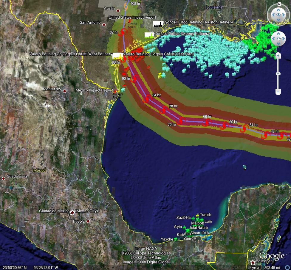
Initial path estimates for Hurricane Ike (Methaz HWRF Sep 9 12Z)-click twice to enlarge
For all graphics: Rigs/Platforms: Blue: evacuated only; Yellow will require inspection before restart; Red: damage requiring repair; Refineries: Black: operational impact (partial shutdown) Green: Operational impact (full shutdown) Red: Damage likely; Ports: standard hurricane flags for wind
We will be posting periodic updates of track and damage forecasts here, because one never knows if one of these events will be seminal. We're not hurricane experts at theoildrum.com. Thankfully we have an expert meteorologist who sends us track and damage forecasts relevant to oil and gas infrastructure. What we try to do on this site, (and have been doing for over 3 years), is articulate the fragility and urgency of our nation's, and our world's, energy situation. As Hurricane Ike moves nearer, and professional analysts gauge the impact it may have on our energy infrastructure, feel free to browse our archives of empirically based analyses and perspectives on the many aspects of our energy situation that form the backdrop not only for this hurricane, but for any exogenous event that disrupts the increasingly uneasy balance between energy supply and demand.
Chuck Watson has put together a dynamically updating page that will reflect the latest damage models/forecasts at this link: KAC/UCF models. We will be updating this thread with damage estimate and breaking news as this story unfolds, as well as post another story on why Hurricane Ike or any exogenous supply event is potentially critical in a world with little slack in supply of high quality oil.
A note on our modeling process: we take the official NHC track, the raw computer model tracks like GFDL, HWRF, LBAR, etc, and even run our own in-house fast cycle track/intensity models. These track and intensity estimates are feed to our main hurricane model (TAOS), which computes the wind, waves, storm surge, currents, etc. at each point in our database of over 50,000 elements in the GoM like rigs, platforms, pipelines, pumping stations, refineries, etc. We then have engineering models for each type of infrastructure that calculates the damage and estimated down time for that element, as well as downstream impacts (eg if a pipeline is down, the upstream elements can't pump and the downstream elements don't get product).
PRODUCTION/INFRASTRUCTURE MAPS AND REFINERY INFORMATION
Here's a link to a really good map of oil refining/SPR storage facilities in respect to the path of Katrina (NB: OLD TRACK MAP!) and here is a listing of production and refining capability for the state of LA.
Just to give you a rough idea of where things are, the map above is a probability swath for Katrina (OLD TRACK MAP!) with the Thunder Horse platform as the red dot, and the other purple dot represents the Mad Dog development (100,000 bd); the Holstein development that produces at peak, around 100,000 bd of oil; and the Atlantis field that may have ramped up to around 200,000 bd in all. Put together these projects have the potential of around 650,000 bd, but as can be seen, they were sitting in an uncomfortable spot relative to the track of the Katrina.The white dot is where Port Fourchon is. This is where the Louisiana Offshore Oil Port, or LOOP, is located. Rigzone pointed out that this is where the foreign tankers offload, Google and Terraserve maps you can see that the area is very low-lying. One of the big concerns is that there will be sub-sea landslides or other ground movement that might affect the LOOP. Were this to be disrupted, then foreign tankers would need to be diverted elsewhere, with the likely port being Houston.
We have accumulated resources from previous hurricans below, but we'd like to find updated materials if you know of them. Recent refinery maps, recent rig maps in the gulf, recent gas fields, SPR facilities, the Intercoastal Canal, pipeline stations and transfer points, etc., etc. Leave links in the comments please.
Also, here's the EIA's Alabama, Louisiana, Mississippi, and Texas Resources pages. They will also likely come in handy. Also, here's a link to the national page.
Here's another good resource for infrastructure maps and such. (scroll down a bit)
Here's a map from CNN with large and small refineries laid out. (though it is an old storm track)
Very detailed piece by RIGZONE on rigs and other infrastructure in the area. (thanks mw)
Here's a flash graphic of the oil refineries and rig maps from Hurricane Rita, it emphasizes Beaumont and Galveston's importance. Click on oil production in the tab. Note the many rigs on the east side of the storm that will get the brunt of the damage from the NE quad of the storm...hence the high long-term GOMEX oil production damage estimates below.
Here's a link to Rigzone's coverage of Ike.
You want a detailed map? Well here's the probably the best MMS map I could find. Very detailed and lots of interesting stuff. (VERY big .pdf warning)
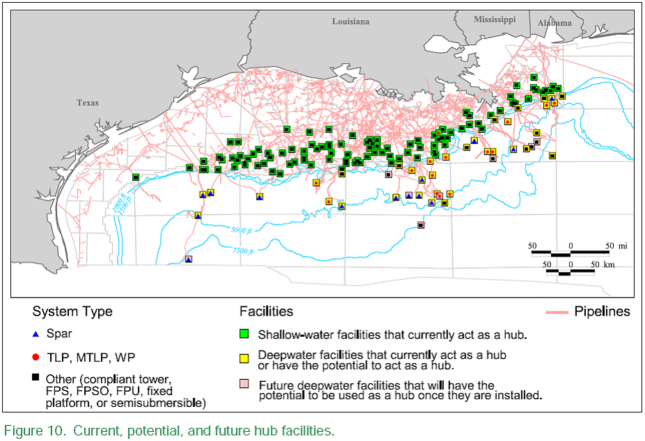
Also, Scott Wilmoth at Simmons & Co was kind enough to send us this map. The map below captures only deepwater infrastructure. For a complete list of deepwater development systems (includes operator, depth, location): http://www.gomr.mms.gov/homepg/offshore/deepwatr/dpstruct.html
(Please deposit new relevant links, graphs, and comments in this new thread...we have updated the resources part of this post with new maps and some more old maps and articles from Katrina on the LOOP and Port Fourchon--important parts of the infrastructure, as we learned about three years ago. Please leave personal anecdotes and themes unrelated to hurricane for the other upcoming 'bigger picture' posts, as some of these larger images are difficult to upload for those on dial-up)
We appreciate your help accumulating resources, stories, and newstips in the comment thread below!
Hurricane Ike, Shut-In Production and Energy Infrastructure (Updated 9/9 10:00 EDT)
PDF version
90 comments
Hurricane Ike, Shut-In Production and Energy Infrastructure (Updated 9/9 10:00 EDT)
PDF version
90 comments
Contact
- Content: editors at theoildrum dot com
- Tech support: support at theoildrum dot com
License

This work is licensed under a Creative Commons Attribution-Share Alike 3.0 United States License.
INTERACTIVE HURRICANE TRACKER :
A nicely done hurricane flash-site with fancy colours, for the wind-people, really worth a visit / bookmark ... over here
http://www.stormpulse.com/hurricane-ike-2008
The site keeps track of all sorts of updated info and history records for older hurricanes as well (and more)
The perfect stike became a split. No way to pick up the spare but the left side appears the likely target this time.
Headed right at Houston.
Flashbacks to the largest short term evacuation of people in the history of the world (Rita).
It's getting late in the season. The coriolis effect will
take over from weak steering currents.
Add in the "ghost tracks" of Edouard, Fay, and Gustav
and Ike will avoid going farther than Vermilion Bay
to the West.
Between PilotTown and Pascagula.
Large Cat 3.
Port Fourchon stays w/o power.
And just what is that thing com,ing out of the Bay of Campeche?
http://www.ssd.noaa.gov/goes/east/gmex/ft-l.jpg
http://www.esl.lsu.edu/quicklinks/hurricanes/2008/IKE/images/latest_fcst...
Coriolis? Sounds like some sort of sexuallly transmitted disease.
I don't know much about the science behind hurricane movement but I can do dead reckoning and read maps prepared by experts.
While some of the tracks agree with your assessment, the overwhelming majority have the thing headed further west.
We'll see soon enough (good Lord willing).
I also can google coriolis:
http://en.wikipedia.org/wiki/Coriolis_effect
http://i.flhurricane.com/images/2008/clark9latest.png
First, thanx for your reply.
Second, Either way, We should know by this evening the way Ike
moves into Cuba.
2a-Here's the Pattern I'm looking at right now.
Again, from Wikipedia-
"The precursor to Hurricane Elena was a tropical wave that moved off the coast of Africa on August 23(1985). It remained weak due to its fast westward motion and Saharan Air Layer around the circulation. As it moved through the Greater Antilles, it slowed somewhat, and a tropical depression formed on August 28 between Cuba and Haiti. It paralleled the northern cost of Cuba, and became Tropical Storm Elena that night. Conditions were favorable for additional development in the Gulf of Mexico, and Elena became a hurricane on the 29th.
A frontal trough of low pressure turned Elena to the northeast, but when the trough outran the storm, steering currents collapsed, leaving behind a stalled, strengthening hurricane in the Gulf of Mexico. It posed a threat to the west coast of Florida,[1] but after the crowds returned to the Mississippi and Florida panhandle coasts, it slowly looped back to the northwest and was changed to a north Gulf Coast threat, prompting another evacuation of the Mississippi Coast."
Third, the Coriolis Effect-(courtesy Wikipedia)-
"Freely moving objects on the surface of the Earth experience a Coriolis force, and appear to veer to the right in the northern hemisphere."
Fourth, whatever that is coming out of the Bay of Campeche,
Ike will not like it. And definitely will not veer into it.
September 10 is considered the peak of hurricane season. Hurricane Wilma came through south Florida in late October, 2005 and made a royal mess of things. I spent 3 days in Collier Co doing roadway damage assessment.
http://en.wikipedia.org/wiki/Effects_of_Hurricane_Wilma_in_Florida
Hurricane season ain't over 'til it's over.
Also, remember that in 2005 we actually ran out of the alphabet of hurricane names, and had to start with Alpha, Beta, Charlie, etc...
The projected path now takes Ike into deep South Texas, somewhere between Brownsville and Corpus Christi.
This means far less of an impact, both on heavy populations and oil facilities. There are some refineries around Corpus.
From latest advisory.
There is a reasonable possibility the NHC will move the track back north over the next 24 hours. Some recent model runs are trending back that way. UKMET model has Ike much nearer Houston for example.
UKMET has been the least accurate so far with projections. GDFL has tracked fairly well. I think the high pressure front coming down from the north will force the hurricane significantly south of Houston (possibly south of Corpus Cristi) for landfall.
And it may well do but for the moment Houston area has advanced into the 4 day cone now. People shouldn't forget that and that's what the NHC is strongly emphasising - not the centre position.
If we're still in the cone tomorrow, I'll start preparing.
And sure enough, at 11am EDT, the NHC shifted track slightly further north in line with UKMET and Euro. New GFS run also moving north and puts landfall north of Corpus Christi. Other models now expected to trend north as well.
http://www.nhc.noaa.gov/text/refresh/MIATCDAT4+shtml/091452.shtml
With the GFS now following this trend as well a further shift north by the NHC is quite likely. Galveston very probably in 3 day cone tomorrow if this trend continues.
Like I said, 8 am tomorrow morning I'll decide what I'm doing.
Seems sensible. I'm just glad to be on the other side of the Atlantic from Ike. Take care.
Ay caramba.
The latest map has Ike turning north after hitting the coast and coming dead over us (Seguin, Belmont, Gonzales).
Those fleeing the coast with horses might want to reconsider coming here (our Seguin Horse Center is a designated hurricane refuge for those with horses).
Watch and wait before making your move. No sense running INTO a storm.
The current track is hands down the worst track that I have seen since Rita, for GOM Oil and Gas production. The current track would not only place the bulk of offshore infra. in the strong quadrant of the hurricane, but, in addition the track almost goes WNW down the entire fairway of GOM infra. To top it all off, Ike could land near Houston, which then puts the refinery complex into play.
If I recall, the area that is due South of the TX-LA border is the area that holds the most amount of shallow water, legacy rigs that are old and not worth being replaced when they get destroyed. Katrina did not come close to this area. Rita, did. Ike looks to be ready to put his strong right shoulder, right through there.
In counterpoint, it appears to me that the GOM super-structure rigs are now much more unlikely to be damaged by hurricanes, in general. So what we see over time in the human-engineering response to hurricanes in the GOM is that infrastructure has moved quickly up the size scale, as a form of protection. This super-sizing trend, however, offers on one hand stronger structural protection against actual wind force. And yet, it represents a loss of diversity, in the GOM. So as time goes on here, we are placing more of our bets on the giant platforms, as attrition sets in on the small stuff.
Meanwhile, the little mosquito infrastructure will survive until its taken out, never to return. As Nate and others have pointed out, the marginal costs of production have exploded way, way past the levels of years ago when alot of this legacy infra. was first erected. The only way I could see little, shallow water rigs being erected again would be when we go through the next repricing cycle, and oil re-prices above 200.00.
If Ike conforms to the current track, as a strong 3 or even a 4, then we are going to have more permanent loss of production from the GOM from the loss of the legacy infra, in addition to gasoline/HO problem for the next 60+ days as Ike affects either or both Baytown/Houston.
Rita: http://en.wikipedia.org/wiki/Hurricane_rita
G
In the last two hours Ike has turned from its west-southwest movement to west. This has been predicted, but its early, and a bit too early to tell if this is a permanent course change, but if it is this could have Ike avoiding running up the spine of Cuba, meaning that it won't loose as much strength.
If Ike ran up the center of Cuba, this would knock him down severely. Moreover, I can't understand why NHC has Ike gaining that much strength so quickly. We saw what happened with Gustav just crossing 40 miles of Cuba (reduced from 4 to 2 and then barely go back to 3). Further, Gustav will have roiled the waters and sapped quite a bit of heat from the Gulf. I have no good source for SSTs, but perhaps someone here does.
I have a hard time seeing Ike going to a strong three or four in Western Gulf on the NHC track. Very different story if it just skirts Cuba!
Conditions are totally different now than 2 weeks ago in Gulf. Many models, including the NHC, have it as a Tropical Storm or weak Cat 1 as it emerges from Cuba, but strengthening still to Cat 3 in GOM at 120 hours (they don't go beyond 120 hours.), as opposed to Gustav which gradually weakened into shore. But from what I've read, meteorologists agree with you - the best to hope for is that landmass of Cuba takes some strength (and therefore potential for future intensification) away.
The one factor that NHC repeatedly misses (or at least rarely mentions) when storms enter the Gulf is the cool dry air factor pulled in from the north, which is what slowed Gustav's rebuilding. At this moment Ike is entraining dry air and preventing strength. As storms enter the Gulf they will pull down cool dry air from the north if it is there. Thats' why so many storms weaken dramatically as they approach landfall.
As Ike enters the Gulf, watch the color water vapor loop and that, more than anything, water temps and shear included, will tell you whether and how fast it can rebuild. If there is humid, wet air over the northern Texas and Louisiana, watch out! At the moment atmospherics over the continent look moderately favorable as dry air is moving out.
Ike's fundamentals are deteriorating as it entrains dry air its core tops are diminishing and its formation is going lopsided. Its feeder bands are small and diminishing. If it slows down even more, Cuba will knock the stuffing out of him and we may yet dodge another bullet.
Not sure that's what I'm seeing on latest imagery but I'm no met.
Eye just moving back over water now.
From the Flhurricane site DanielW, Cuba has never killed a hurricane.
I lost the source, but think that's true.
But you could give me an example of a Cat3 or higher that Cuba has shredded? I think you'll be hard pressed.
Thank you,
James
Going back to 1970 there hasn't been one single storm that tracked right up the center (or even close) of Cuba. George (1998) came closest, skirting the coast going on and off land for about 100 miles repeatedly and was knocked down to a TS. Nearly all storms cross Cuba the in the narrow cross-section. Beyond 1970 there are no track maps available that I know of. Hispanola has killed quite a few.
Here you go, 2008(IKE) <======== 1969 ===========>> 1880's (beyond?)
http://www.stormpulse.com/1969-hurricane-season
http://www.stormpulse.com/1890-hurricane-season
This is the real deal (!) for tracking old storms or IKE's progress today (use the searchfield for particular year or storm-name)
cool site.
but fyi historic 'canes have little bearing on the current climo, synoptics and particular conditions that are presently associated with Ike.
yes the site is very cool, and as for the present stats on hurricane IKE the info here seems to me quite updated .... "Latest Update Sun, Sep 7, 2008, 11:00 AM EDT"
http://www.stormpulse.com/hurricane-ike-2008
If you play with the "buttons" in the map-window (upper right corner , press more) you get all sorts of added info, like various forcast models, clouds, historical tracks and all sorts of crazy info ...
It is the real deal for "storm-folks" :-) very impressive stuff OMHO
Disclaimer for this site
Source:
Hispanola has the highest mountain east of the Rockies. At 10,000 feet it would make it difficult for a storm to even track across DR. No storm has ever tracked directly across the big island of Hawaii either but they have two 13,000 foot peaks. One hurricane got close enough to the big island a couple of years ago to interact with the southern mountain and it had the stuffing knocked out of it. It was amazing to watch on satellite.
"I have no good source for SSTs, but perhaps someone here does."
I have used these to get a handle.
Go 3/4 down page. links for:
"Sea Surface Temperature Data
* Sea Surface Temperature imagery from NOAA/NESDIS
* Caribbean Sea Surface Temperatures
* Gulf of Mexico Sea Surface Temperatures
* Atlantic Sea Surface Temperatures
* 30-day forecasts for Atlantic (U.S. Navy)
* Sea Surface Temperature imagery from U.S. Navy"
http://www.wunderground.com/tropical/?index_region=at
Jeff Masters latest forecast for Ike
Track forecast for Ike
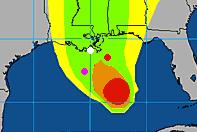
Ike has stopped moving west-southwest, and is now moving due west. A turn to the west-northwest is expected Monday. The latest 06Z (2 am EDT) computer models have shifted slightly north, but still predict Ike will track inland along the spine of Cuba for a day or longer. Along this track, Ike would likely weaken to a Category 2 or even a Category 1 hurricane. However, it would take only a very small deviation from the forecast track for Ike to spend much less time over Cuba and primarily track over the warm waters of the Florida Straits instead. While none of the models are currently predicting this, I give it a 30% chance that Ike will arrive at the Keys as a major hurricane of Category 3 or 4 strength because of an unexpected wobble to the north. The SHIPS intensity model predicts Ike will be a Category 4 hurricane with 135 mph winds if this happens. The Lower Keys including Key West are at greatest risk, and a maximum storm tide of 9-10 feet (Figure 2) can be expected in the Lower Keys in this scenario (storm tide is storm surge plus an adjustment in case Ike hits at high tide). I strongly encourage Keys residents to pay heed to the mandatory evacuation order and leave today. Ike could easily be much worse than Wilma was. If Ike does spend the expected 24-36 hours over Cuba, only tropical storm or Category 1 force winds are likely in the Keys.
Once Ike emerges into the Gulf of Mexico on Tuesday, a trough of low pressure passing to the north may be able to induce a more north-northwesterly to Ike, and pull it towards the Florida Panhandle, bringing tropical storm force winds to Tampa on Wednesday. The HWRF is the only model showing this, and the rest of the models push Ike more to the west, into the central Gulf of Mexico. The eventual landfall locations predicted by the models range from Alabama to the Mexican border. It is too early to have a feel for where Ike will go at this point, since landfall is probably 6-7 days form now.
Intensity forecast for Ike
Sea surface temperatures (SSTs) have warmed to 29.5°C underneath Ike and will warm to 30.0°C over the Gulf of Mexico. Shear has dropped below 10 knots and is expected to remain below 10 knots for the next four days. As long as Ike is not over Cuba, it has very favorable conditions for intensification. Once Ike passes Cuba and enters the Gulf of Mexico, the intensification potential remains high, as shear is predicted to be below 15 knots, and the waters are hot.
I'm watching Oil Storm first half of hour and the film is excellent.
BTW Ike might go south of Cuba and curve again on the trajectory of Gustav.
Uh oh! Ike has turned WNW early! This is no established track yet, but more than a wobble. If this continues Ike will spend a lot less time over land. Doubtful that it will turn enough to miss completely but is looking a lot more like Georges path.
From what I can see we will probably know by 2100 hrs CST whether Ike will ROAR or WHIMPER into the Gulf. By that time the trend should be well established.
If this goes into the Gulf as a 2, we are in for big trouble. However, I just checked the infrared SST's and find that the straits are not real hot and its clear that Gustav definitely brought the gulf temps down. No hot loop current is even visible. Therefore it doesn't look likely that Ike will be capable of explosive strengthening.
from what i understand it will be a much stronger storm if it goes north of cuba, but also miss energy infrastructure far to the east (AL/MS). If it goes across cuba or south it will track into GOM, but probably start as only a tropical storm. The strengthening would then be up to conditions in GOM at the time, which look favorable for further deepening. The scenario of going north of cuba, shooting FL straits, keeping cat 4 status then going west of alabama is not in any of the meteorolical predictions i have seen - going north now would be a good thing (for energy not for FL residents).
Or there is the possibility to go between Florida and Cuba into the GOM!
This isn't what I'm reading.
Jeff Masters Wunderground
Water temperatures near New Orleans are cooler than the rest of the gulf (as they were when Gustav passed. I wonder if that has anything to do with the water coming out of the Mississippi?)
However, west of New Orleans, all the way to the Texas coast and South to the Mexican border the water appears quite warm.
How much does strenth entering the GOM correlate with storm strength six days later, at likely landfall? My intuition would say that the strength it enters the gulf, is not that important, and that the strength several days out will be strongly determined by the conditions during the final two to three days. Of course I am not a hurricane guy. But, it seems that the concept of being rescued (or not) by land interaction with Cuba is only minimally relevant (unless it turns NE and hits Florida shortly after Cuba). Remember Katrina entered the GOM as a cat 1, but then had several days of ideal conditions.
Hello TODers,
Some random musings on Ike & Cuba:
Gustave recently hammered the western side of Cuba, and unfortunately, Ike is on track to hammer the rest of this island. Will these two storms start to send Cuba into a downward spiral of Haiti-like conditions, and what are the future strategic ramifications?
With Mexico poised to collapse soon, will the US ignore Cuba's plight so that resources can be husbanded for aiding Mexico in the future, or alternatively, securely closing the long Mex border? Or is the US now so broke that it will be announced that Haiti, Mexico, and Cuba are on their own? What is the economic tipping point where the US military must abandon our overseas adventures to concentrate on nearby Mexico and the GoM & Caribbea?
If Cuba gets hammered: will Russia again view this as a strategic opportunity to offset NATO encroachment on their border? If Russia is headed into internal net energy decline: maybe Putin will join the US in announcing that Cuba, and thus most Third World countries, are now on their own too.
Or will Venezuela and Chavez view Cuba as ripe for annexation? More immediate timeframe musings: imagine Gitmo being overrun by desperately hungry Cubans, then threatening to release the prisoners unless the US sends massive amounts of aid and rebuilding materials to Cuba. Since Mexico's navy is so weak, will Cuba launch a desperate assault invasion on the Yucatan using Chavez's help? Would the US Navy have to get involved?
Or would the US postPeak encourage Cuba, Mexico, and the rest of Central America to exchange blows so that US emigration pressures would be reduced? Or is it just lots of Easter Islands ahead with all that implies?
Lots of possibilities, and I certainly don't have the answers, but things maybe much clearer as soon as Ike clears Cuba. HINT,HINT: This might be fertile TOD-keypost areas for Jeff Vail, Gary Brecher [Warnerd], and John Robb [GlobalgGuerrilla] as I don't expect the Pentagon to assign a flag admiral to write TOD keyposts.
Bob Shaw in Phx,Az Are Humans Smarter than Yeast?
It would be interesting to see a Russian coastguard ship delivering aid to Havana. Or a Russian naval fleet, carriers, submarines, warships, the whole lot bringing humanitarian aid to the Caribbean :)
Do you think the US would mind?
Oh, I'm sure that the mainstream US media would run all types of stories about how fortunate Cuba is to have a benefactor like Russia.
Hypocrisy has no limit.
Hello Burgundy,
Thxs for responding. With Russian prodding, imagine postPeak and fast-collapsing Mex & Cuba instituting something similar to the present day Ukrainian fee/charge for the FF & natgas traversing their country, then continuing on to Western Europe.
Mexico and Cuba could both buy Russian anti-ship missiles to blanket the Yucatan Slot, then demand a cash percentage from every ship passing thru this narrow channel heading for US ports [or else blammo]. The insurance companies would freak out. Mexico and Cuba could also use this as leverage to force the US to continue taking their Overshoot emigrants that are trying to leave the dire in-country lifestyles.
If Cuba, with additional missile batteries, can also cover the Florida Strait, the GoM won't see much shipping traffic. That should provide plenty of incentive for the US to rebuild and expand the continental RR infrastructure [AlanFBE's ideas] real fast as every ship could only use the Western or Eastern seaports! For additional fun: imagine the Panama Canal under joint Russian, Chinese, and Iranian control when the US cannot afford its bluewater Navy anymore.
Who knows how things will turn out when a superpower implodes.
Hey Burgundy,
The Russian battlewagons may be docked in Havana Harbor real soon:
http://www.nytimes.com/2008/09/08/world/americas/08venez.html?ref=world
----------------------
Venezuela Announces Early Plans for Military Exercises With Russia in Caribbean
...“Go ahead and squeal, Yanquis,” Mr. Chávez said in a mocking tone on his Sunday television program, adding, “Russia’s naval fleet is welcome here.”
----------------------
Some may like to see what the weather geeks have to say
http://www.climatepatrol.com/forum/33/3982/pg2/index.php#pid18938
Some comments are scary :-(
I wish them to be wrong.
The discussion on climatepetrol also has an interesting discussion about the Gulf Stream. Something has happened and may be related to the intensity of the current Hurricane Season. See the comments for March 2008.
http://www.climatepatrol.com/forum/10/2484/pg9/index.php
Ike's turn WNW is now quite pronounced although still too early to plot a course. Even so, its looking more and more like Ike is heading into almost clear sailing. It's possible it misses Cuba altogether or just gives a little kiss. The weak ridge over Florida seems to be retreating. Doesn't look good for the oil patch.
The National Hurricane Center just released their 5 pm update, stating:
Cuba's coastline is WNW so missing it will be quite a feat, but Ike is trying hard.
Can the electric power transmission towers be constructed in a way that would allow them to withstand Cat 3 or even Cat 4 winds?
Could the way the power lines attach to the towers be modified to make it easy to take down the power lines before hurricane winds hit and then put them back up again after the winds pass?
If we enter a period of lots of hurricanes in quick succession we need to find ways to adapt. Moving away from floodable areas is part of the solution. But it would be good to be able to withstand heavier winds too.
Apparently France had a bad storm in 1999-00, and so they are putting many of their lines underground.
They also maintain their roads and bridges, and are building more railways, so it is perhaps unlikely that the US's attitude to infrastructure will allow similar investment - they have better things to spend the money on, like F & F.
For High Voltage (New Orleans region has 14 HV DC lines of 230 kV and 500 kV). go to higher % steel wires (Iceland has world's highest @ 50% steel). stronger towers, perhaps more closely spaced.
Underground is simply not practical for voltages in this range.
Alan
Presumably then France is putting the lower voltage lines underground, which reduces the number of lines the crew has to take care of.
The relatively few high voltage lines can anyway be built to a higher standard.
The situation may indeed be different, but in Germany one of our guys informs us that after the same storms with over a 1 million homes disconnected, they restored 95% within 24 hours.
Sounds bit like when the UK had a proper National grid.
A way to mitigate risk to distrupted electrical distribution is to implement Feed-in Tariffs allowing distributed power generation.
We have too many eggs in one basket and that basket keeps getting kicked.
If we do not like the consequences of centrally planned and managed infrastructure then de-monopolize government management by allowing free markets to distribute and innovate alternatives. It is working well in Germany.
Back in '05, my husband and his boat ran to Galveston to get out of Katrina's way, then to Fourchon to get out Rita's way. I'm a little worried that, with the shape Fourchon is in, it won't be a viable port in a storm, should Ike track towards Galveston.
Right now, he is working a deepwater rig in Keathley Canyon. It's 2-day run to any port, be it on the Texas coast or the Lousiana coast. Looking at the forecasts, it appears that Keathley Canyon is right in Ike's crosshairs.
Any thoughts on where an offshore oil rig supply vessel might run for shelter?
Once he's out in deep water, my husband is completely incommunicado.
Hello MarinersWife,
I am confused--Are you saying his boat doesn't have a Marine Band Radio? He is Nuts not to spend the money on this cheap insurance! He could also have a satellite phone--works anywhere in the world.
Sorry. What I meant by "incommunicado" is that I won't hear from him while he's out there. Of course his boat has capability to communicate within the oil field (Marine Band and such). It also has a satellite phone, but using it to contact home is generally frowned upon, because it's very expensive. Crew members can use it in an emergency, IF they have the opportunity to do so. Under normal conditions, boat crews, especially engineers, work non-stop 18 to 20 hours a day, 7 days a week. In emergency conditions, like with a hurricane bearing down on them, well... there are not enough hours in the day. It's "balls to the wall", as my husband puts it, 24/7.
Hope that phrase does not offend.... It's just that it describes the manic pace of a merchant mariner's work life better than anything else I can think of.
Thxs for the reply. I hope your husband is extremely careful.
Hello TODers,
Something more to consider on Gustave, Ike, and Cuba:
According to the CIA Factbook, Cuba has approx. 11.5 million people. IF these two hurricanes' massive rainfalls and the giant storm surges succeed in washing offshore most of the Cuban topsoil and their piles of O-NPK products [composts & manures]-->Cuba may have enter the I-NPK & sulfur markets BIGTIME to re-energize their topsoils back above potential Liebig Minimums.
Picture formerly rich, organic, mulchy farmland as now scoured, residual sand and pebbles full of ocean sea-salt. Rather difficult to get high harvest yields from this soil condition. :(
Have you hugged your bag of NPK today?
NYMEX CRUDE up 2.17
Not much of a spike considering what's going on.
and I am guessing that's weak dollar trading not hurricane trading.
Big oversupply in the rest of the world keeps crude prices subdued at the moment. There's a lot of material in the North Sea, Nigeria and S-A that needs to find a home at the moment. So you'll see a very different response to hurricane news than in a situation where world crude supply is tight.
Hello TODers,
I have been doing a little research on Cuba & agriculture.
From this link you can see the yearly I-NPK importation in table format:
http://www.nationmaster.com/time.php?stat=agr_fer_con_met_ton-agricultur...
-------------------------
2002 [latest avail. data] 121,900 tons, but back in the 1980's the yearly avg was roughly 550,000 to 650,000 tons yearly.
-------------------------
Sorry, I don't know how to make those cool charts. Anyhow, the I-NPK decline was caused when the USSR collapsed plus the US embargo forcing Cuba to go mostly organic:
http://www.wsicubaproject.org/resourcemanagment.cfm
------------------------------
...It has been estimated that around “50 percent of Havana’s vegetables come from inside the city, while in other towns and cities urban gardens produce from 80 to more than 100 percent of what they need,”[12] leaving produce that cooperatives can sell for a profit.
..Despite the benefits of urban and organic agriculture, however, Cuba still faces great challenges in providing its citizens complete food security. The country continues to issue food rations, supplies are quickly depleted, and it is often difficult for citizens to acquire certain goods without hard currency.
...Despite such efforts, however, Cuba’s environmental record is not perfect. Firewood, for example, was cut for household fuel,[26] as could be expected in times of economic crisis. Indeed, one report states that the “increased demand for firewood has brought about the indiscriminate cutting of trees and bushes, adding to Cuba’s already serious problem of soil erosion.”[27] What sets the country apart from others facing similar situations, however, is the concerted effort of the government to direct its scarce resources towards combating such actions. The country even managed to increase the amount of tree cover despite the economic hardships. Between 1990 and 2000, forest area in Cuba increased by 13 percent, as compared to an 11 percent average decrease in Central America and the Caribbean, and a 2 percent average decrease worldwide.[28]
---------------------------------
My feeble analysis:
So if these two hurricanes hammer Cuba badly, not only will they lose roofs off buildings and collapsed grid power, they might also lose much of their urban farmland to flooding and erosion, besides the immediate spoilage of the present crops and sparse stored foodstuffs. The power shortage combined with rural farmland erosion and windblown forest trees toppled will set off a national rush for firewood for cooking and water-heating, plus additional rural acreage converted to offset the urban permaculture lost acreage.
Additionally, Cuba might need I-NPK not only for their forced expansion of urban and rural permaculture, but even more I-NPK for a massive tree replanting effort to reduce/reverse anymore deforestation and consequent landslides. The highest point in Cuba: Pico Turquino 2,005 meters high.
Therefore, Cuba might be ideally seeking to purchase annually one million tons of many types of I-NPK products until their O-NPK system is fully functional again in five or more years.
But with global I-NPK prices expected to rise even without this new Cuban demand, plus Cuba itself being short of currency reserves, this just may not be possible. Even if Cuba gets an immediate injection of food aid: if they cannot be self-sufficient in growing their own food--> eventual starvation will probably eventually lead to a series of postPeak revolutions and other machete' moshpit effects. With all the Cuban sugarcane--> My guess is there is no shortage of machetes' in Cuba. :(
Selected data from the CIA Factbook:
https://www.cia.gov/library/publications/the-world-factbook/geos/cu.html
-----------------
GDP/capita $4,500 (2007 est.)
Public Debt 36.8% of GDP (2007 est.)
Reserves of foreign exchange and gold: $4.247 billion (31 December 2007 est.)
Debt - external: $16.79 billion (convertible currency); another $15-20 billion owed to Russia (31 December 2007 est.)
-------------------
If potent I-NPK like DAP is $1,000/ton, Cuba cannot afford to buy much of this for very long:
One million tons @ $1,000/ton = $One Billion USD
Will the US and/or Russia and/or KSA ante up the bigtime funds to keep Cuba from becoming another Haiti? Or is this now just impossible if the planet is going postPeak?
Bob Shaw in Phx,Az Are Humans Smarter than Yeast?
Hello TODers,
Latest NHC IKE Update:
-------------------------
000
WTNT64 KNHC 080149
TCUAT4
HURRICANE IKE TROPICAL CYCLONE UPDATE
NWS TPC/NATIONAL HURRICANE CENTER MIAMI FL AL092008
950 PM EDT SUN SEP 07 2008
...IKE MAKES LANDFALL IN EASTERN CUBA...
THE EYE OF HURRICANE IKE MADE LANDFALL ON THE NORTH COAST OF EASTERN
CUBA IN THE PROVINCE OF HOLGUIN...NEAR PUNTO DE SAMA AROUND 0945 PM
EDT...0145 UTC. MAXIMUM WINDS AT LANDFALL WERE ESTIMATED TO BE 125
MPH...205 KM/HR.
$$
FORECASTER PASCH/KIMBERLAIN
------------------------------------
Yikes!-->125 mph sustained winds! My best hopes go out to those poor Cubans riding out this monster. I can only say that I hope my Cuba analysis postings will turn out to be wildly overblown.
Bob - here ya go:
By all means download OpenOffice and learn to put some of your fascinating data into graphic form. I've been thinking of starting a thread on making charts etc. over at peakoil.com, too. That would be an excellent topic for Drumbeat as well, of course. We've many more visual presentation stars here at TOD. That would definitely be one for the bookmarks.
You want to host your image at a site like ImageShack. In this case I used PicOodle since ImageShack seems to be on the fritz. These sites provide the code to display your image here in thumbnail form (as I did), which saves bandwidth big time.
Very often you can find a good chart by searching for something on Google Images, too. Again, if the file's a huge 'un it's good manners to host the file at ImageShack or the like.
As you are at this topic: You saved this image as jpg, which is a format for photos. Graphs like this one are better saved as png or gif, providing a crisp picture and saving bandwith.
NHC 2:00 AM Advisory
AT 200 AM EDT...0600Z...THE CENTER OF HURRICANE IKE WAS LOCATED NEAR
LATITUDE 21.2 NORTH...LONGITUDE 76.6 WEST OR JUST INLAND NEAR THE
THE NORTH COAST OF EASTERN CUBA IN THE PROVINCE OF LAS TUNAS. THIS
POSITION IS 85 MILES...135 KM...EAST OF CAMAGUEY.
IKE IS MOVING TOWARD THE WEST NEAR 14 MPH...23 KM/HR...AND A WEST TO
WEST-NORTHWEST MOTION IS EXPECTED OVER THE NEXT DAY OR TWO. ON
THIS TRACK THE CENTER OF IKE WILL MOVE OVER MUCH OF CENTRAL CUBA
TODAY...AND BE NEAR OR OVER WESTERN CUBA ON TUESDAY.
MAXIMUM SUSTAINED WINDS ARE NEAR 120 MPH...195 KM/HR...WITH HIGHER
GUSTS. IKE IS A CATEGORY THREE HURRICANE ON THE SAFFIR-SIMPSON
SCALE. WEAKENING IS LIKELY AS IKE MOVES OVER CUBA DURING THE NEXT
DAY OR SO.
HURRICANE FORCE WINDS EXTEND OUTWARD UP TO 60 MILES...95 KM...FROM
THE CENTER...AND TROPICAL STORM FORCE WINDS EXTEND OUTWARD UP TO 140
MILES...220 KM.
ESTIMATED MINIMUM CENTRAL PRESSURE IS 945 MB...27.91 INCHES.
At 5:00 this morning Ike is a Cat. 2 hurricane.
MAXIMUM SUSTAINED WINDS ARE NEAR 105 MPH...165 KM/HR...WITH HIGHER
GUSTS. IKE IS A CATEGORY TWO HURRICANE ON THE SAFFIR-SIMPSON SCALE.
ADDITIONAL WEAKENING IS FORECAST AS IKE MOVES OVER CENTRAL CUBA
TODAY.
And here's how Ike looked as it made landfall as a high end Cat3/borderline Cat4. Image taken 3am GMT (11pm EDT)
Image from http://www.nrlmry.navy.mil/TC.html
And here's what it hit
Holguín Province
Thanks for the humanitarian perspective on Cuban sustainability and their I-NPK dilemma, Bob. Let's hope Russian assistance is in the works.
For future reference: Rigzone maps of production in the path of Gustav, ported over to Imageshack in case RZ takes them off their site. Originals here: Gearing Up for Gustav
The latest updates to Ike's position and forecasts are not good for oil production:
1- Instead of continuing to go over Cuba as predicted, Ike has gone West to sea. This means it will not weaken as much as predicted before entering the Gulf, it may even strengthen if it moves further West to deeper waters.
2- Ike is forecast to become bigger due to interaction with Cuba, with some professional forecasters saying its windfield might become as big as the Gulf itself.
3- Conditions are still favorable for strengthening over the Gulf.
Anything from a Cat 2 to a Cat 5 over the oil patch wouldn't surprise me at this point. A Cat 3 or Cat 4 seems more likely.
PS: I'm not an expert, this is all based on what I'm reading about this storm (NHC forecasts and professional/amateur opinions at storm2k).
As of 11:15am EDT, Ike has made it into the Carribean. 11am NHC update takes this into account. Based on that update the cone centre 5 days from now is virtually right on top of Houston. Must be noted though that the cone of uncertainty is still very large and this could still hit almost anywhere from the Florida panhandle to South Texas. However the consensus of the models is definitely trending towards Galveston/Houston area as a Cat 3 or greater with an extremely large windfield due to interaction with Cuba.
It looks as though the Russians have perfected weather control - for the 11am weather update GFDL, which apparently had the best record in predicting Gustav, is going for a track which pretty much hits the oil production just to the west of the job Gustav did, slap bang in the middle of the oil rigs, whilst NHC is going for a hit just west of Houston:
http://tropics.hamweather.com/2008/atlantic/ike/modelsmap_zoom1.html
Those darn commies in Havana still look like getting theirs, though, after a swing out to sea it is supposed to be turning north to go straight in there, so perhaps it is the CIA in control after all, and the oil industry is collateral damage.
If you really need something put into space for a reasonable cost, or weather, the Russians can do it.
The oil price peaks a few days before landfall, at least the average of Rita, Katrina, Dennis and Gustav. About one week after landfall, the oil price is back to its pre-hurricane level.
I can't seem to manage to include a picture, here's a link to the picture in question.
http://4.bp.blogspot.com/_-CXk2-VWGgQ/SMUt4yvVQQI/AAAAAAAAAB8/_hWilou8yc...
Update on Forecast for path and intensity of Ike:
Posted by JeffMasters of weather Underground, 10:13 AM EDT on September 08, 2008
http://www.wunderground.com/blog/JeffMasters/comment.html?entrynum=1072&...
Track forecast for Ike
The Florida Keys are probably off the hook. It now looks unlikely that Ike will bring hurricane force winds to the Keys. Ike continues to move due west, and the eye may pop out to the south of Cuba at times between now and Tuesday morning. It is unlikely that the eye will move far enough from the coast for significant strengthening to occur, though. Passage over Cuba has disrupted the eyewall enough that it would take at least 12 hours over water for the storm to reorganize, and Ike probably won't get that kind of time over water. Ike is expected to track west-northwest on Tuesday into the Gulf of Mexico, passing near or over Havana, Cuba. The expected track should bring tropical storm force winds of 50-70 mph to Key West and the Lower Keys on Tuesday afternoon.
The latest 06Z (2 am EDT) computer models no longer expect a turn northward towards the Florida Panhandle. As we've seen many times this hurricane season, the models were over-enthusiastic about the intensity of a trough of low pressure passing to the north. High pressure has been dominant over the eastern U.S. the past month, and the models have consistently been underpredicting the dominance of this high pressure. The current steering pattern, with high pressure entrenched over the eastern U.S., steering hurricanes into Florida and the Gulf Coast, is similar to the steering pattern of 2004 and 2005. This steering pattern has acted to steer six straight storms into the U.S., and is not expected to change significantly over the next two weeks, according to the latest long-range forecasts from the GFS model.
As Ike moves approaches within 300 miles of the Louisiana coast on Friday, there will be another trough of low pressure capable of turning the storm to the north. The GFS, GFDL, HWRF, NOGAPS, and Canadian models all predict that this trough will be strong enough to turn Ike northwards into central or western Louisiana. The UKMET and ECMWF models disagree, and think high pressure will dominate enough to force Ike westwards into Texas, between Corpus Christi and the Louisiana border. These two models have been trending too far south with Ike so far, so I would lean towards a landfall in western Louisiana at this point.
Intensity forecast for Ike
Ike will probably be a tropical storm or Category 1 hurricane on Tuesday afternoon when it emerges into the Gulf of Mexico. It will take the storm a day or two to reorganize. Wind shear is expected to be light (<10 knots) and water temperatures will be high, near 30°C, so Ike will probably intensify into a Category 3 hurricane by Thursday. Once Ike approaches the coast on Friday and Saturday, the total heat content of the ocean declines, and the shear is forecast to rise to a moderate 15-20 knots. The GFDL and HWRF models respond by weakening Ike to a Category 1 or 2 hurricane at landfall in western Louisiana. This is a reasonable forecast, but our skill in predicting intensity changes this far in advance is poor.
The 5PM long range track on Wunderground has him pretty much splitting the difference between Corpus and Houston, as a Cat 2 or 3, Saturday early landfall. The GFDL has him pretty much marching up the Houston ship channel.
Subject to change, of course...
or, to put it another way, "we don't really know for sure."
Update on Forecast for path and intensity of Ike:
Posted by: JeffMasters, 10:20 AM EDT on September 09, 2008
http://www.wunderground.com/blog/JeffMasters/comment.html?entrynum=1074&...
Track forecast for Ike
A trough of low pressure is currently passing to the north of Ike, and this trough has been able to turn Ike north of due west. Ike is now moving west-northwest, and this motion is expected to continue today, taking the storm across the western tip of Cuba, where Hurricane Gustav crossed just two weeks ago. By Wednesday, Ike is expected to take a more westerly motion again, as high pressure to the north builds in. As Ike approaches Texas on Friday, a new trough of low pressure is expected to pass to the north, potentially turning Ike to the northwest.
The latest 0Z/6Z (8 pm/2 am EDT) computer models show a variety of timings and strengths for Friday's low pressure trough, resulting in a high amount of uncertainty on where Ike will make landfall. Most of the models predict the trough will arrive too late and be too weak to affect Ike, and take Ike ashore near the Texas/Mexico border. These models include the NOGAPS, GFS, and GFDL. The HWRF is bit farther north, placing landfall near Corpus Christi, and the UKMET and ECMWF are farther north still, targeting a region between Freeport and Galveston. Oddly, these two farthest north models were the southernmost ones yesterday. Suffice to say, the crystal ball is still cloudy. The entire Texas and northernmost coast of Mexico are at risk from Ike.
Intensity forecast for Ike
While Ike is over Cuba, slow weakening will occur. Significant strengthening will not occur until Wednesday morning, after the storm has recovered from its crossing of Cuba. Water temperatures are a warm 29.5°C in the Gulf of Mexico, and wind shear is expected to be modest, 10-15 knots. Ike will be crossing over two regions of high heat content associated with the Loop Current and a Loop Current eddy (Figure 2). The GFDL and HWRF models show Ike responding to these favorable conditions by intensifying to a Category 4 hurricane on Thursday. By Friday, wind shear is predicted to increase to 15-20 knots, but the heat content of the ocean remains relatively high. There is much higher oceanic heat content off the Texas coast than was present off the Louisiana coast for Gustav. Thus, it is less likely that Ike will significantly weaken as it approaches the coast. The GFDL and HWRF models predict landfall in southern Texas as a Category 3 or 4 hurricane Friday night. The SHIPS model is less aggressive, and foresees a Category 1 or 2 hurricane at landfall. So take your pick--Ike could be a Category 1, 2, 3, or 4 hurricane at landfall. Such is the state of long-range hurricane intensity forecasts. A middle of the road forecast of a Category 2 or 3 hurricane at landfall is a reasonable one at present.
Another site to look at is Fox 13 I don't know how to post the link, but you can get it thru' Google.
Hello TODers,
http://ap.google.com/article/ALeqM5irQiP58k56Qjh5q9EljABJm1SJgQD9328VLG0
-------------------------------
Rice: Not wise to end Cuban economic embargo now
--------------------------------
I wonder if this increases the likelihood of Russian & Venezuelan warships docking in Havana to deliver aid after Ike finally clears this island nation?
Let's just hope that the Pride of the Russian Fleet, the nuclear-powered battlecruiser 'Peter the Great', doesn't have a mysterious 'Remember the Maine' kind of event if it docks at this seaport.
http://en.wikipedia.org/wiki/Remember_the_Maine
If Russia is going postPeak, but has designs on grabbing control of Venezuela's oilfields [like the US in Iraq], it might be more likely for a naval accident [incident?] to occur in a Venezuelan port. This could soundly establish a 'Putin Doctrine' to counterpose the 'Monroe Doctrine & the Bush Doctrine'.
http://www.google.com/search?hl=en&q=putin+doctrine
Superpowers sometimes treat their allies the worst. Will Russia manipulate Chavez like the US manipulated Saddam Hussein? Time will tell...
++
EDIT: Just as the US is bringing democracy to Iraq, it does not take a great leap of imagination to picture Russia [possibly China too?] bringing democracy to Venezuela. If the US & Nato are trying to bottle up the Russian Black Sea fleet [see Georgia & Ukraine], it would only make sense for Russia to move their naval base to Venezuela if they lose Sebastapol.
++
Alternatively, I wonder if Al-Qaeda [or some other radical group] is interested in a Russian version of the USS Cole attack? I bet Tom Clancy could have a great time writing a book on this geo-political extrapolation.
Bob Shaw in Phx,Az Are Humans Smarter than Yeast?
tot,
Interesting thought about Russian involvement with Vz oil fields. I'm not sure it would take overt action. We're always hearing reports of Vz difficulties maintaining its production infrastructure. Hugo might welcome some Russian engineers into his oil fields especially if they bring the equipment/capital with them. He already has the Chinese in country doing just that. Additionally, Hugo signed a multiyear supply contract with China last year. It would certainly allow Putin a visible oportunity to poke us in the eye.
Hello TODers,
We tend to be concentrating on Ike's potential upcoming damage to the US 's oilfields, but has anyone done a damage assessment on Cuba's offshore and onshore petro-infrastructure?
http://havanajournal.com/business/entry/pebercan_finds_new_potential_oil...
-------------------
Pebercan finds new potential oil field off Cuba and more wells planned
Published: Wed February 15, 2006
------------------
I hope that their safety engineering and training is equal to the US standard, otherwise the towering waves from Ike might be sending an incredibly huge oil slick to Florida's beaches.
Methaz, this is beyond my expertise, but the Pentagon & State Depart. might give you a juicy contract to analyze Cuba for them. :)
Bob Shaw in Phx,Az Are Humans Smarter than YEast?
As simple as it gets:
Oil is down to $104.25.
Even as Ike will be a Cat3 in the GOM and production
is at a standstill.
Disciplined prime brokerage margin clerks > hurricanes.
Here is a chart of Ike's history up to 1500Z 09 Sep 2008:
Ike weakened significantly over Cuba, and likely could degrade further when crossing the island's west side. Maybe tropical-storm strength as the cyclone enters the GOM. According to the NHC, Ike, while moving along Cuba's south shore, has maintained a small eye (6-8 nautical miles in diameter as revealed by Cuban radar systems), and a central pressure of approximately 965 mb. With sustained winds of 65 to 70 knots, Ike is still a potent storm.
The following graph, a basic method of following storm tracks with Excel, shows that Ike is now passing over territory swept by Gustav:
If Ike sticks with its current trajectory, as is expected by NHC forecasters, then the hurricane will soon be south of Gustav's path.
-best,
Wolf
Hello TODers,
As Ike clears Cuba and heads into the GoM: I bet things will now get much worse than this:
http://www.pww.org/article/articleview/13523/
-------------------------
Cuba: 55 years after Moncada
..Food import costs, for example, are up 30 to 40 percent this year, to $2.5 billion. Cuba imports 70 percent of its food. Half its agricultural land lies idle.
-------------------------------
For those seeking more detail [68-page PDF Warning]:
http://www.fas.usda.gov/itp/cuba/CubaSituation0308.pdf
-------------------------------
Cuba’s Food & Agriculture Situation Report
by Office of Global Analysis, FAS, USDA
March 2008
Executive Summary
Since 2002, the United States has continued as Cuba’s largest supplier of food and agricultural products. Cuba has consistently ranked among the top ten export markets for U.S. soybean oil, dry peas, lentils, dry beans, rice, powdered milk, and poultry meat. Cuba also has been a major market for U.S. corn, wheat and soybeans.
...Nevertheless, most food crops during the past three years have shown declining output trends. Cuba has become increasingly reliant on food imports to feed its people. Cuba’s total food and agricultural imports almost doubled between 2000 and 2006.
--------------------------
Hurricanes Gustave, Hanna, and Ike may now have sent Cuba on a course of massive decline. Is Cuba's Olduvai immediately ahead?
Bob Shaw in Phx,Az Are Humans Smarter than Yeast?
Ike has moved into the gulf, and is still looking quite formidable.
This doesn't sound good.
The eye of Ike has returned very quickly once back over water. I've never quite seen this type of hurricane behavior where it reformed that quickly after being over land for so long. I think with this type of organization, Ike has a high potential for getting back up to a low 4 category before hitting the western GOM. It is also jogging/pointing more northerly than the models have been showing, but hard to tell exactly with the wobble in the eye. I think anywhere from center coastline of Texas up to the Texas/Louisiana border has equal probabilities of direct hits, but depends on the interaction of Ike with the deep layer ridge in the northern GOM. If it fads, then Ike could steer more northwesterly.
This morning the entire Texas coastline wakes up to find itself in the three day cone of a projected Cat 3.
From what I understand, don't be surprised if the cone continues to shift more to the north over the next 24 hours as the models continue to come into more agreement. The 5 day cone (at top of thread) shows a strong bend towards the north. The timing of that is critical and the current NHC track is still a bit to to the south of the model consensus.
Evacuation order issued for Brazoria County coast
CNN: Earthquake at sea in Indonesia - magnitude 7 tsunami potential.
It all seems to be happening at once....
Before you got to bed. If you are in a mandatory or voluntary evacuation zone then leave now immediately.
No ifs, no buts. The probabilities are really turning against you if you don't.
Last chance to go is now.