| Peak Oil, Peak Debt, and the Concentration of Power | The Oil Drum | Sunday Times Predicts US As Top Oil Producer in 2017 |
Tech Talk - Reaching the Oil: Offshore Alaska
Posted by Heading Out on September 13, 2011 - 3:06am
I have tried in the last two OGPSS posts to show some of the problems that are developing in the flow of oil from Alaska to the rest of the United States. Based on a falling volume of oil produced from the existing fields in the North Slope, the delivery pipeline from Deadhorse to Valdez is approaching levels of flow which will make it more difficult to deliver that oil. There are fields in the region that are still being developed. Alaska_geo has pointed to several developments that are likely to take place over the next year, mainly in exploration but including the development of the Umiat field. One of the mechanisms that the Alaskan Governor has proposed to help encourage industry was to provide a road up to Umiat. The oil reserve for the Umiat field is estimated at 250 mb, but the road may take another five years to finish.
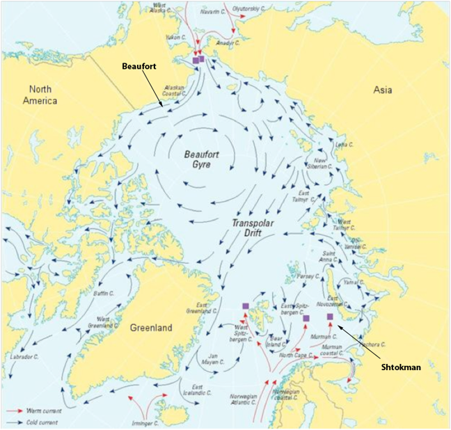
As with the subjects of the last couple of posts not everyone knows where the different places are in Alaska, so since one of the intents with this post is to look at off-shore deposits, let me put up a new map.
.png)
You will notice that the map shows Deadhorse rather than Prudhoe Bay; this is because that is the official name of the population center. There are a number of possible reasons for the name and I am partial to the one told by Deborah Bernard.
Once upon a time, a very famous, very rich man in New York set up a $6 million trust fund for his son. The only catch was this son couldn’t collect the money until he was 35 years old. The young heir went to Alaska . . . met some people who owned some gravel hauling equipment (and) talked the father into co-signing a loan for this company. . . Things went from bad to worse and he found himself in possession of several dump trucks, pieces of equipment, and a hauling company. He put the heir in charge of it and named it “Deadhorse Haulers.” (The) father, disgruntled that he was financially responsible for the ill- fortuned gravel company, said, “I hate to put money into feeding a dead horse.” Hence the name.
Which may also be why folk prefer saying that they work at Prudhoe Bay!
The major new exploration, however, will take place offshore, with Shell seeking to send two drilling rigs to the region to drill two wells in the Beaufort Sea and three in the Chukchi Sea, as I mentioned last time. (And I should perhaps have mentioned that of the $4 billion investment Shell is making some $2.1 billion went to the Federal Government in the lease sale). The total oil resource available in these seas has been estimated to be as much as 25 billion harrels of oil (bb) and 127 Tcf of natural gas. Alaska will be selling leases to an area of some 14.7 million acres this fall, though the sale has just been postponed until December.
It said the acreage involved, covering roughly the size of Massachusetts, Vermont, and Connecticut combined, would include 2 million acres in the Beaufort Sea as well as leases adjacent to the federally-controlled Arctic National Wildlife Refuge and the National Petroleum Reserve-Alaska.
The problems that will be encountered should the fields be this rich are not just limited to those involved in proving the presence of the hydrocarbons through drilling. Production and transportation of the fuel is a non-trivial exercise. Offshore wells will be located in the Arctic where the ice moves subject to wind and current.
sea ice in the Beaufort Sea has more time to grow and reach the thermodynamic equilibrium thickness, so it is thicker. Also, because of the circular rotation of ice in the Beaufort Sea, ice floes frequently bump into each other. Ice deformation is common and leads to thicker and more ridged ice compared to other regions.
Unfortunately, the flow patterns are also not consistent, and may on occasion reverse, thus making the design of systems to survive in those conditions more challenging.
In fact, this the region around the North Pole, from the Beaufort Sea over to the Russian side and fields such as the Shtokman are where the some of the latest technical challenges lie. One problem is that there are not enough US icebreakers, and one of these, the Polar Sea, will be decommissioned at the end of the month while its sister ship, the Polar Star, has been laid up since 2006. There will then be only one remaining, the Healy.
So how does one drill and produce in such an environment? Initially the exploration wells are drilled using drill ships, though these can only operate during the time that the sea is ice free, which varies from year to year.
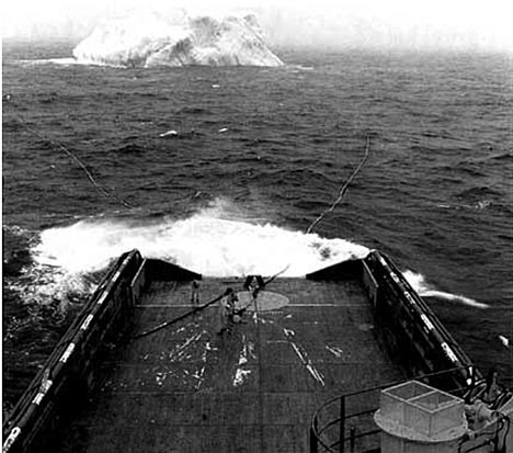
This limits the time of operation and can be a much more restrictive problem closer inshore and at times when larger and more permanent operations are planned. There is, after all, only so many places you can pull errant icebergs out of the way as the season develops. (The market for hauling icebergs to Arabia never developed). And the problems come in all sizes.
Support vessels servicing the rigs are also in danger, not from the big bergs, readily visible as they tower from the ocean, but from the small growlers and round-tops, often undetectable on radar and virtually impossible to see in the North Atlantic waves. In some areas, sheer numbers aggravate the problem. The drill ship West Navion had to deal with over 200 bergs and deflect more than seventy while drilling in the Davis Straight.
As a result, ice islands are built that can give more protection to the site, and these can be reinforced with concrete, if needed.(Though it is cheaper just to spray on more water).
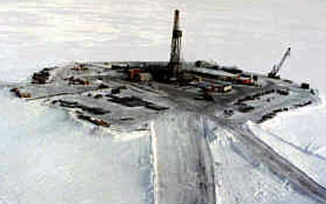
A number of wells can then be drilled from each island using horizontal drilling techniques to reach out into the reservoir surrounding the island. The islands themselves can be built using a spray technology to build up the ice, since this seems to give a cost advantage* over using gravel or flooded bays to form the structure. The islands can either be build over land or from a floating platform.
The Mars Island took 898 hours to construct over 46 days, using over a million cu m of water. This island is 26 ft thick and 700 ft in diameter.
Technologies such as these will allow development of the reservoirs, though it should be remembered that the fuel has to then be brought into some sort of transport system that can move it to processing and future customers. That issue is of even greater concern with the reserves of natural gas found in the Arctic regions, and so I will move on to talk about it next. But for now I will leave you with the thought that even though there may be considerable oil reserves in Alaska that remain untapped at this time, their ability to significantly change the current and near-term global supply in a positive way is realistically almost non-existent.
*Ice Island Study, Final Report MMS Project #468, by C-Core, August 2005
Contact
- Content: editors at theoildrum dot com
- Tech support: support at theoildrum dot com
License

This work is licensed under a Creative Commons Attribution-Share Alike 3.0 United States License.
HO - Nothing to add. Just wanted you to know someone appreciated you effort.
how do they keep the island from floating away?
As far as fuel goes you need to process the gas on the north slope to get diesel or DME.
It's a good summary and has a lot of useful information in it.
Since I worked for a company that ran a fleet of 26 ships on the Canadian side of the Beaufort Sea for decades and spent billions of dollars drilling offshore wells, I can add a bit about the geology. It's nothing at all like the Gulf of Mexico. There has been too much tectonic activity in the Arctic Ocean area, so most of the oil reservoirs have been fractured and the oil has escaped. Also, the deep formations have been much hotter than the GOM, so most of the remaining oil has been cooked to natural gas by thermal cracking. As a result the area is heavily gas-prone. We found lots of interesting things, but we didn't find any commercial oil deposits.
We (or rather one of our competitors) drilled one good oil well on one of the Arctic Islands which produced for years - they took the oil out every summer with a strengthened tanker, but it's since been plugged and abandoned. Other than that it was a complete waste of time and money - billions of dollars.
I wouldn't hold my breath waiting for big oil discoveries up there. I think the US government estimates are delusional, at best. There's lots of natural gas up there, but there's also lots of shale gas in cheaper, more southerly areas, so it doesn't make economic sense to develop the Arctic gas until the shale gas is used up and prices double or quadruple.
There's a bit of a boundary dispute on where exactly the dividing line between the American and Canadian sectors of the Beaufort Sea is. When the US bought Alaska from Russia, the Russian and British Empires hadn't agreed on the boundaries between their territories. The land borders have since been resolved, but the US and Canada don't agree on the exact sea boundaries.
Avoiding the floating sea ice is definitely a big problem. We had a $1 billion drilling platform at risk, so I helped design a computer system to monitor the radars and weather instruments and calculate the probability of the platform being crushed by ice. The plan was that if an ice floe came too close, they would disconnect from the well, pick up the anchors, and run for safety. Then after it went by they would go back and try to reconnect with their well. There's not much you can do to stop the ice from coming at you.
It would seem that based on your experience and theory about oil in the arctic, Prudhoe Bay doesn't exist either.
Prudhoe Bay would appear to be anomalous. The biggest oil field in the US, but the only big oil field in the US sector of the Arctic.
Once you've found all the big oil fields, that all there are, and I think we've already found all the big oil fields in the world.
I guess it's anomalous....as long as you don't count Kuparuk (only ~3 billion bbls) or Alpine or Pt McIntyre....etc. Yes, Prudhoe is the biggest oilfield in the US. It is also the biggest conventional oilfield in North America (including Canada).
I think I would like to wait and see what Shell finds in the Beaufort and Chukchi, and what Exxon/BP find in the Canadian Beaufort. No one doubts that peak oil is real, or that the size of discoveries is declining. But there is still a good deal of oil to be found, probably including some sizable fields in the Arctic.
I should have been more technical and said "supergiant" rather than "big". Sure, Kuparuk is "big" at 2 or 3 billion barrels, but that is not a real elephant in the global context. Prudhoe Bay was much, much bigger, at approximately 13 billion barrels, of which 2 billion barrels is left. The second biggest field in North America, East Texas, has produced over 5 billion barrels to date.
Even Prudhoe Bay caused only a temporary bump in the US production decline curve. At current US consumption rates, it would amount to about a year of oil consumption.
Maybe I'm a little negative about the potential of the Arctic because we spent billions and found a lot of things that didn't include any commercially viable oil deposits. Been there, done that, didn't even get a T-shirt to celebrate.
Other people I worked with bet their pension money on Arctic oil. I guess their pension plan now involves pushing a shopping cart from dumpster to dumpster in hopes of finding enough returnable bottles to buy a can of cat food. Sorry, I can get really negative because this is what happened to people I know.
On the other hand, the oil sands research I did has worked out really well from the standpoint of providing a comfortable retirement income. Most of Canadian oil production comes from the oil sands these days.
Dang right, RMG. And, at world consumption rates, that 25 BBL lasts all of 284 days!
To find oil, I think you need to look for areas where there were aluvial (is that the right word) deposits - rivers running into the sea or a lake, and where the deposits were covered, then subducted to an area of pressure and heat where the magic of oil could happen. This is not dinosaurs or forests we are talking about (those are mostly coal).
Geologists should be able to determine where the most likely locations are, and I surmise that they have pretty much run down all of them to find the "elephant" fields.
Does anyone know where else we can find these particular conditions? If not, we are in a heap of trouble...
Granted, a few fields will be located; history shows us that any gains in production have to come from existing fields, from techniques that allow recovery of more oil. At some point, either the difficulty in extraction is so great as to be non-economical, or there is really "no oil left." (I would add, I am surprised at how often when I bring up peak oil those listening think that is what I mean.)
I have seen nothing lately that would make me believe that our oil plateau will be followed other than by a steep decline. How that plays out in the economy is problematic - it seems to me that either oil prices go through the roof, or they remain constant while everything else drops like a rock. In either case, our consumer based industrial society cannot continue.
Now... my real question is why, with these facts seemingly evident to all who are paying attention, is no one with a serious stake in that society, and with either platform (media or political) or money sufficient to influence policies or to take direct action, doing so? I am mystified.
Craig
I think you are using too broad a brush, (it seems to me) painting the entire arctic gas prone.
That would depend on whether or not the poster is familiar with the thermal maturity of the sedimentary basins involved. In which case they may be able to make exactly that assumption.
That would also depend on which arctic sedimentary basin we are talking about (Hint: there are several).
That would also depend on which portion of which sedimentary basin we are talking about (hint: different parts of the larger basins have different thermal history).
That would also depend on which petroleum source rock in which part of which basin we are talking about (hint: there are several distinct source rocks in these basins, which are at different relative depths, and which achieved different levels of thermal maturity at different times, in different parts of the basin).
Yes, in my humble opinion, the original poster was painting with a rediculously broad brush. Arctic geology is not nearly as simple as some would like to make it.
I would agree.
Having mentioned this, a quick run through of the most recent USGS assessment of the overall Arctic (undoubtedly encompassing many of the basins which you are familiar with, and perhaps even more) reveals that the expected undiscovered ratio of gas to oil runs perhaps 18,000 SCF to 1 barrel of oil? At the means?
If one were to paint with a broad brush, that sounds awful gassy, on average, to me. And certainly the USGS can guess at what is thermally mature, and in which basins, and in which parts of which basins, better than most of us.
Spock,
I have no problem with the idea that there is much more gas to be found than oil in the arctic. And, in the broad sense, I don't have a quarrel with the USGS assesments, provided one understands what they are. They are a best guess, based on whatever data is currently available (which for some basins is very little). I might add that several of the USGS folks who made those assessments are friends of mine. Maybe the reality is much worse than they think....or maybe not. They have made an educated guess. We won't know until we drill.
Saying there is a lot of gas is not the same as saying there is no significant oil. However, some posters have taken the stance that there is little or no significant oil remaining to be found in the either Alaska or the arctic in general. In my opinion, I don't think the available data supports that opinion. Also, I might remind you that Shell/Exxon/BP collectively know a thing or two about arctic geology. Based on the fact that they have put some pretty serious money on the table, I infer that they also think there is some significant remaining oil yet to be found up in the Alaskan, Canadian, and Russian arctic.
Making blanket statements like "...There has been too much tectonic activity in the Arctic Ocean area, so most of the oil reservoirs have been fractured and the oil has escaped Also, the deep formations have been much hotter than the GOM, so most of the remaining oil has been cooked to natural gas by thermal cracking. As a result the area is heavily gas-prone...." as if that uniformly applies to the entire Russian, Norwegian, Greenland, Canadian, and Alaskan arctic margin is bullshit, in my humble opinion. It is a very big place. While certain areas have been heavily explored, there are other areas we really don't know very much about.
Could new discoveries in the Alaskan or Canadian arctic completely reverse the long term decline in world production? No, in my opinion. Could it help buy us some time for whatever comes after? Maybe. When you drill wells for a living, one thing you learn very quickly is that the earth is full of surprises. Some are pleasant surprises, and some are not. We won't know unless/until we drill.
Now I'm going to bed and get some sleep. Unlike certain posters, I'm not retired. I still work for a living, and I have some wells to worry about tomorrow. Good night.
I might remind you that Shell/Exxon/BP collectively know a thing or two about arctic geology. Based on the fact that they have put some pretty serious money on the table, I infer that they also think there is some significant remaining oil yet to be found up in the Alaskan, Canadian, and Russian arctic.
Or at least they may project that it will be economically feasible to extract when the price rises significantly.
The two propects Shell plans to drill in the Beaufort are both known oil accumulations, discovered in the '80s. At the time, based on the drilling and production technology then available, they were considered uneconomic to develop. Also, back then, we only had 2D seismic. Shell has shot state of the art 3D over both prospects. Obviously, based on the size of their investment to date, they don't share RMG's pessimism regarding the arctic.
Likewise, BP and Exxon have recently invested significant amounts of money in the Canadian Arctic. The Canadian and Alaskan arctic is a rather large place. Some areas are indeed mostly gas. However, it is well to remember that Prudhoe Bay is still the largest conventional oil field ever discovered in North America (including Canada), and is still producing more than 40 years after discovery.
The arctic is a big place, and the geology is not the same everywhere. Past failure in the Canadian Arctic does not necessarily imply future failure in Alaska, or further offshore in Canada.
It is true that Prudhoe Bay is the largest oil field in North America, but it may well be anomalous. Elephants of that size can't hide, not even in the Arctic. We were able to detect good prospects from aircraft, and I'm sure that using modern technology you could find them from orbiting satellites.
We drilled all the prospects we found, and didn't find anything that was commercially viable. That is not to say we didn't find anything, we found oil fields up to 500 million barrels, but a field that size is not economic in the high Arctic. You have to realize that the benchmark for economic cost was the Alberta oil sands, and we already know where the oil sands are.
As an aside, there is a major oil sands deposit on Melville Island in the Canadian Arctic. The oil sands deposits in Alberta are much further south, so maybe they will start to develop Melville Island in the next century, after the Alberta deposits are exhausted.
And, of course, I would like to mention that the Canadian Arctic is much bigger than the American Arctic, just as Canada is bigger than the US. Not that I'd want to make Americans feel inferior or anything.
That's right. And you were looking in relatively shallow waters. In the current round of Canadian Beaufort exploration Exxon and BP are going further offshore. Dome et al never explored that far offshore. The area that is being currently looked at in the offshore Canadian arctic has never been seriously explored.
It is true that by itself a 500 million bbl field in the arctic will not support the construction of a pipeline. However, if one or more billion+ bbl fields are discovered further offshore, many of those smaller fields will suddenly become economic. That is exactly what has happened and continues to happen in Alaska.
Published estimates of Shell's two prospects in the Alaska Beaufort are on the order of 100 to 200 million bbls. That is based on 80's vintage seismic and drilling. I am guessing that Shell thinks there may be more there. Note that an onshore pipeline now extends as far east as Badami. In the next year or two it will be extended to Exxon's Pt Thomson development. This means that there will be an onshore pipeline more or less to the point where Shell would bring oil ashore.
RMG, you can certainly choose to assume that your past experience in the arctic was the last word on the subject. However, Shell, Exxon and BP obviously disagree with you. Between them, those companies have quite a few fine geologists and engineers working for them. And they are betting many billions of dollars that you are wrong.
As always, we will have to await the drill bit to find the answer.
In the next year or two it will be extended to Exxon's Pt Thomson development. This means that there will be an onshore pipeline more or less to the point where Shell would bring oil ashore.
A point RMG pointedly chose to ignore ?- )--though as H O mentioned, getting that oil ashore may be no mean task. Any insights on just how tough it will be to safely ship any offshore arctic oil to shore?
The entire offshore Shell effort has been a challenge but they persist--maybe they are just fond of bashing their heads against the ice ?- )
Up in Deadhorse back in 2008 I had a few conversations with Shell's man coordinating the then ongoing offshore seismic. He said one big problem they had encountered was the lack of reliable three to seven day extended weather forecasts for the arctic seas. Since it took near three days to haul the seismic gear out of the water things could get awful dicey with not near enough warning. 2007 of course was the summer when the winds decimated the sea ice so it must have been especially fun that year.
(edit)Of course the guys that did 2d seismic back in the day had interesting times as well--my next door neighbor less then fondly remembers getting airlifted out of camps as the ice was 'exploding' all around him.
Speaking of 2007 ice--it is beginning to look like that year will keep the record for lowest minimum arctic sea ice extent for another season

of course that depends on the weather for the next few days. Last year the minimum ice extent was on September 19.
"Speaking of 2007 ice--it is beginning to look like that year will keep the record for lowest minimum arctic sea ice extent for another season"
Depends which source for that statement you look at... ;)
I use the NSIDC page as my reference. They do refer to the Bremen measurements regularly, however. NSIDC is just a handy one stop shopping site for me.
Today I'd almost be willing to bet that the arctic sea ice surface area will continue to wax until spring 2012. The Intellicast Infrared Satellite 'World' page has finally emerged from its garbled pixel spell and seems to be showing calm weather patterns up north and a consolidating equatorial cloud band. Probably won't be enough wind to reverse the arctic freeze up for the next week or so. But life can be full of surprises...
Sea ice area is fractal. It depends on how closely you measure it. Other teams using newer, higher resolution sensors, indicate this year the sea ice extent is below the 2007 level, but we are splitting hairs.
The estimate of sea ice volume for 2011 is 30% below the value for 2007. AT the current rate of volumetric melting the arctic sea will be ice free in August 2021.
Where did you get the 30% info? The source would be very useful/important.
Fractal area? In what sense? The closer you look at an area of ice to measure, the more it looks like an area of ice to be measured? I'm just too far removed from the mathematics at this point.
The source for Arctic seaice volume is usually the PIOMAS model. See for instance Neven's excellent blog on Arctic seaice.
Nice link--this chart is so dramatic I though it had a place in post devoted to arctic oil exploration and production
I certainly don't.
;-)
"Not that I'd want to make Americans feel inferior or anything" And neither do us folks in Texas.
There is an old joke around these parts that goes something like this:
"Because of it's vast size, it was proposed to congress that Alaska be divided into two states, to make it easier to administer. However, the plan was blocked by the Texas delegation. It seems the reason they objected, was because then Texas would be the 3rd largest state."
I used to try to avoid making Texans feel inferior by telling them that Alberta is 2% smaller than Texas. Unfortunately Alberta is only the fourth largest province in Canada, but if you avoid mentioning that, and avoid mention its oil reserves, you can leave Texans feeling sort of semi-important.
Okay, I tried to help but "big" is a relative concept.
Rocky - Sorry buddy...you're still living in the 19th century. Landmass size isn't important any more. It's EGO, baby, EGO. Go ahead...challenge us on that basis. Make my day!
It would be really nice if the "all we need to do is Drill Baby Drill and we'll be independent and gas will be $2" crowd would take the time to read unbiased information like this and grasp the technological challenges involved in the attempts to feed our fossil fuel appetite at the current rate. Mother Nature is in charge where much of these efforts will be carried out, and the only rules She obeys are those of physics.
I'll also second Rockman's comment that I really appreciate your Tech Talks.
We should drill anyway. Not doing so is like not picking up a 20.00 dollar bill because you will not be able to retire. Global warming will not change if we drill there or not. IMO
Well, it would technically make global warming a little worse. It's also putting money into a guaranteed failure since eventually the oil will run out again. Thats before we talk about the cost of this oil, and how we would deal with a blowout.
Which is to say we probably couldn't deal with a blowout there.
I'm thinking that in a few more years we will have a much better handle on the progress of anthropogenic global warming, and it may well become rational to wait for that part of the world to warm up to the point where drifting ice is not so much of a problem as it is now. Then all those reservoirs that RMG and his company found will become economic to produce... maybe.
I don't think we could deal with a large blowout or spill there at all. At least it is far enough away to make it much easier to try to fool people into believing that the oil was cleaned up. The Gulf spill wasn't cleaned up. It was mostly dispersed; into the air and into the water.
The Exxon Valdez oil spill is still ongoing 22 1/2 years later. Last week there was cleanup activity on the beach of Latouche Island of oil from the Exxon Valdez from 1989. If you dig down a bit on many beaches that were severely oiled you will find oil still there. Perhaps I'm a pessimist but has there ever been a successful cleanup that actually had the oil removed from a large spill or blowout?
Well, the Valdez spill certainly hasn't been recovered, nor has the spill been ongoing for 22-1/2 years. I wonder about the cleanup of big spills as well, certainly you want them to happen in the warm waters of the GOM rather than the Arctic. Warm temps can sure come in handy, making things like Ixtoc and the Macondo blowout dissipate. Cold temps in the Arctic just don't allow natural processes to handle the problem as well.
Just wait. As technology improves, we will become able to exploit economically ever smaller and lower quality oil reserves. In time, technology will have improved so much that the Exxon spill will be financially recoverable.
/.End sarcasm
In the mid 1960s I was on an old Navy icebreaker, pre-1945 I think, and we tried pushing a tiny iceberg near McMurdo with virtually no effect except to dent the bow. We did, however, send PR photos to the press, and the following year a couple of similar icebreakers got their photo into LIFE Magazine. Since an iceberg will follow the current I guess (as the post said) the idea is to reposition it in the current, like white water rafting on the Colorado but in very slow motion. But being able to tow a given iceberg in open sea doesn't mean one can do so readily near shore or shoals surrounded by pack ice under pressure and being driven by wind.
One concern I would have with these islands offshore of Northern Alaska is "How do you keep the ice sheets from just flowing over the islands?" I know the ice sheets can flow ashore for some distance.
The platforms are fairly large, and have been placed, in some cases, so that they end up sitting on the seabed, and thus generate an anchor in that manner.
Article on ice hazards seemed to be about glacial ice "true icebergs". To my knowledge there are no glaciers terminating in the sea on the north shores of western Canada or Alaska. Sea ice should be a different animal. Hibernia is off the Canadian Maritimes, and sea icebergs from Greenland.
Although I started just talking about Alaska, I was trying to tie in (through the mention of Shtokman) some of the problems that are more common to working in those waters in general. Because we had been peripherally involved in looking at putting anchors into icebergs as a way of making it easier to haul them around, I was going to do a little self-promotion, but then as the post developed decided not to. But I thought the idea of moving icebergs - more as you say a problem elsewhere, would be of general interest so I left that bit in.
,*; I am really thankful to this topic because it really gives useful information *”~
I was unaware of these problems with our Coast Guard icebreaker fleet. If the Polar Sea and Polar Star are both out of commission that leaves only the Healy for Arctic duty. The rest of our icebreakers are in the Great Lakes or Northeast, and they're built for lake and harbor duty and buoy tender duty, rather than the open ocean.
Are there commercial ships that fill the gap? The Russians have always been ahead of us in this space - how do I learn more about the condition of their fleet? And how does this play with the dramatic crash in ice extend and volume? Are we letting these ships slide because they simply won't be needed in a few years?
The Polar Star is undergoing a refit and will be reactivated in 2013.
"- how do I learn more about the condition of their fleet?"
Russian nuclear icebreakers
Nice article. Also, just minutes before reading this I read the following article:
Unearthing Arctic riches requires a fortune
Extracting oil, minerals requires huge infrastructure investments, and global warming isn't helping in the cold, stark environment
http://www.msnbc.msn.com/id/44349323/ns/business-world_business/
Decent treatment of the problems involved in getting out minerals, oile & gas in the artic. And this is in the heart of Canada where there is no ocean to contend with nor any right of way disputes.
Also interesting is that warming temperatures up there are seen as more of a problem than a solution to extracting the "riches".
Best hopes for other more "sustainable" solutions in warmer climes.
I have time for just a quick note now. I'll try to expand it a bit later. Ice islands are really used only for exploration, and then only in very shallow water. An ice island is just a temporary (winter only) feature. Well bores drilled from ice islands, even if they succeed in finding oil, would generally be plugged and abandoned. If a prospect is suffienciently delinieated to be worth developing, then a permanent gravel island would be built.
Alternatively, drilling can be done from an artificial island. Gravel is piled up above sea level to create an island from which a well can be drilled. If successful, the artificial island can be converted to a permanent production facility. In this case they are usually reinforced to prevent the gravel from being eroded. Endicott Field, NE of Prudhoe currently produces from such an artificial island. North Star (north of Prudhoe) is another example of production from an artificial island in shallow water. BP's Liberty project, which is now on hold but will probably go forward, will be drilled from such an island. In that case, rather than build a new island directly over the accumulation, BP has opted to expand one of existing islands (a satellite to Endicott). That's the reason for the extreme extended reach planned for the Liberty wells.
A variation on this is one of the caisson drilling structures. Back in the mid 80's I spent some time on the "CIDS" ("Concrete Island Drilliing Structure") when Exxon tested the Antares prospect. This was a concrete caisson floated out into the Beaufort Sea, filled with water and sunk to provide a drilling platform. In that case, an ice wall was built around the CIDS to provide additional protection from floating ice. The summer after the end of the (unsuccessful) project the CIDS was refloated. It was stored unused for several years in Prudhoe Bay. I believe it was then moved to Russia where it now serves as a permanent production platform.
In deeper water, such as where Shell now plans to drill, exploration is done in summer from a floating drillship, often with icebreaker support. If successful, it is likely a sea floor completion would be done and the oil brought ashore with a subsea pipeline. Because of sea ice, there might not be any permanent above water structure.
Edited for minor typo's and to add North Star as an example.
It may be that companies are betting on the most alarmist ice melting predictions.
http://thinkprogress.org/romm/2011/08/09/291788/arctic-death-spiral-sea-...
This piece from Joe Romm's "Climate Progress" has a graph showing the Artic ice free for 6 months a year by 2021.
The projection is questionable since it extrapolates a nonlinear trend into years with no data.
Why would someone spend 5 years building a road to get to a 250 mb reservoir? It does not seem worth it to invest that much time and energy into one days worth of reserves. I am willing to bet that road will never be built
There are other potential development opportunities in the Brooks Range foothills. A road could improve the economics for them and encourage more exploration. Developing infrastructure such as roads is, after all, one of the functions of government.
How many dollars are you willing to bet? Whether or not it will be built remains to be seen. However, at the moment the State seems quite serious about it. At least that's the message I get from friends who work in various state agencies.
I worked at one time along an oil pipeline here in the US built during WWII. It was clear to me the line was built very quickly to a "git er done now" standard. A far cry from how it is allowed to be done now, but they knew how to do it. The pipeline is still delivering crude today. Safely and cost effectively. I would bet that push come to shove, a serviceable road could also be built quickly and cost effectively.
A key requirement would be minimizing project complexity.
I worked pipeline right of way in some extremely rugged areas. D-8s get winched up & down 30% inclines, men, women and machines blast through vertical rock, we can do it relatively quickly. Our legal and political system is so much more complex now, and seems to have lost its quickness and flexibility, and appears to lack the focus to regain it.
I always hesitate to say 'impossible,' SG. So, I will only say that building a road that could service oil wells in the Arctic areas is a serious problem.
First of all, permafrost is constantly melting and refreezing. To go to bedrock is difficult, but again not impossible. What is is time consuming and extremely expensive.
That oil pipe in the lower 48 did not have those considerations. The Alaska pipeline had to be built to a different standard. For smaller fields, we may need $200 oil to make the expense of servicing and transporting affordable. Not that it won't happen.
Craig
Now you have to understand that the state has a couple oil dollars to spend for the next couple/few years. If spending those oil dollars on an arctic road has a decent chance of extending TAPS life and thus keeping more oil dollars flowing into the state longer (and of course those might be higher priced oil dollars to boot) it might not be all that bad a place to spend the money. Additionally the construction expenditures do help keep the state's economy limping along in the near term.
There is some local opposition to the road however.
While it will certainly be difficult and expensive (compared to lower 48 roads), it may not be quite as tough as you think. Recall that the ~400 mile Dalton Hwy (aka the "Haul Road") was built in about a year, crossing the Brooks Range. Since then, as part of the process of developing the N Slope oil fields, we have gained a good deal of experience in building roads in the arctic.
If built, this will be ~100 miles, over consdierably less formidable terrain. See The Road to Umiat for more information.
From the ref in my comment above about the proposed gold mine in IQALUIT, Nunavut/BAKER LAKE, Nunavut, Canada, and although we have gotten better at building roads in the Artic it is still tough, expensive and usually are only open a few months during the year:
"Most workers have to be flown in, as long as the often foul weather cooperates. The only land access is a gravel road the company built to Baker Lake, a small town 70 miles to the south. The road — which was supposed to cost $172,000 a mile to build — came in at $344,000 a mile."
"Heavy equipment, spare-parts and diesel fuel all arrive during a short summer shipping window, first by barge and then along that costly road."
""We know how to build on permafrost, we know how to build on non-permafrost. What we don't know how to do is build on permafrost that will thaw," said University of Ottawa professor Antoni Lewkowicz, a leading permafrost expert.
Softening permafrost
In parts of the Canadian and U.S. Arctic, buildings are already starting to collapse and roads crumble as the frozen ground warms up."
". . . Nunavut is currently so dry and cold that the average snow cover is only around 2 feet in winter, when frozen lakes and rivers can be turned into ice roads for the heavy trucks that supply the mines.
One such road, stretching 370 miles to the Diavik and Ekati diamond mines in the Northwest Territories and then to the abandoned Jericho diamond mine in western Nunavut, costs around $36 million a year and operates for around eight to 10 weeks."
"...usually are only open a few months during the year..."
The Dalton Hwy is open year around. In the winter, ~250 trucks per day travel up to Deadhorse. Note that this involves crossing the Brooks Range at Atigun Pass (elevation 4,739 ft / 1,422 m). The branch road to Umiat is planned to also be an all-season road.
See The Dalton Highway
Edit:add wikipedia link for info on Dalton Hwy
Not much to add to your summary on the Dalton but as I'd posted a couple of summer 2010 pictures taken from near the top of Atigun a couple Tech Talks ago I though I'd drop the TOD permalink to those shots here.
Atigun is beautiful in the summer but I remember reading a trucker's decription of negotiating that pass during fairly common 'near' whiteout winter conditions. He said it was like 'trying to drive with a piece of white butcher paper covering the windshield.' No one said it was an easy open year around road.
We've been throwing out a lot of Alaska place names. As HO noted up top, that can no doubt be confusing to many who are not familiar with the geography. A good place to start, with lots of information, is the Alaska Division of Oil and Gas website. In particular, go to their North Slope Maps and Publications page.
Note that in previous posts I have referred to Endicott Field. The official name, used on state maps, is "Duck Island Unit".
At what point do we start talking about outer space for oil? It won't surprise me. How can you run an economy reliant on cheap oil by replacing the cheap oil with expensive, hard to get at oil? Will the Alaskan pipeline even be flowing in 5 years?
MrEnergyCzar
Yes
How can you run an economy reliant on cheap oil by replacing the cheap oil with expensive, hard to get at oil?
So, what then is your answer to your question - the Bachman option of "forced" cheap fuel?
There are two answers - either get used to running the economy on expensive oil, or make it less oil reliant. Almost every other country is choosing less oil reliant. OF course, the more oil reliant you stay, the more oil you use, and the faster you use up your cheap stuff and are forced to use the expensive stuff - that is pretty much where the US is at.