Whither Wilma?
Posted by Heading Out on October 23, 2005 - 8:30pm
THE CENTER OF WILMA IS FORECAST TO BE NEAR THE SOUTHWESTERN COAST OF THE FLORIDA PENINSULA EARLY MONDAY MORNING. HOWEVER...WILMA IS A LARGE SYSTEM AND TROPICAL STORM FORCE WINDS WILL REACH THE FLORIDA KEYS AND FLORIDA PENINSULA WELL BEFORE THE EYE MAKES LANDFALL.UPDATEDDATA FROM AIR FORCE AND NOAA HURRICANE HUNTER AIRCRAFT THIS EVENING INDICATE MAXIMUM SUSTAINED WINDS HAVE NOW INCREASED TO NEAR 110 MPH...175 KM/HR...WITH HIGHER GUSTS. WILMA IS A STRONG CATEGORY TWO HURRICANE ON THE SAFFIR-SIMPSON SCALE. ADDITIONAL STRENGTHENING IS POSSIBLE TONIGHT AND EARLY MONDAY... AND WILMA COULD BE NEAR CATEGORY THREE...MAJOR HURRICANE... STRENGTH AS IT NEARS THE SOUTHWESTERN FLORIDA COAST MONDAY MORNING.
HURRICANE FORCE WINDS EXTEND OUTWARD UP TO 85 MILES...140 KM... FROM THE CENTER...AND TROPICAL STORM FORCE WINDS EXTEND OUTWARD UP TO 230 MILES...370 KM. A WIND GUST TO 85 MPH WAS RECENTLY REPORTED IN HAVANA CUBA... AND A GUST TO 55 MPH WAS REPORTED AT DRY TORTUGAS. SUSTAINED TROPICAL STORM FORCE WINDS ARE OCCURRING OVER THE YUCATAN CHANNEL AND WESTERN CUBA... AND THESE WINDS SHOULD REACH THE LOWER FLORIDA KEYS BY MIDNIGHT... AND SPREAD EASTWARD TO
THE MIDDLE KEYS AND THE SOUTHWEST FLORIDA COAST BY SUNRISE MONDAY MORNING.
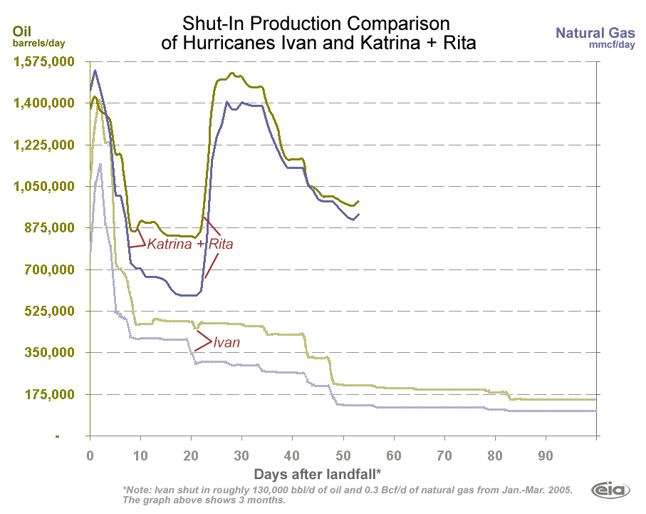
These evacuations are equivalent to 25.76% of 819 manned platforms and 11.94% of 134 rigs currently operating in the Gulf of Mexico (GOM).In this regard we seem to have reached a plateau in regard to improvements. UPDATED At ericy's suggestion I have included this graph from the EIA , and this related to his comment on the likely level of the plateau.Today's shut-in oil production is 986,805 BOPD. This shut-in oil production is equivalent to 65.787% of the daily oil production in the GOM, which is currently approximately 1.5 million BOPD.
Today's shut-in gas production is 5.337 BCFPD. This shut-in gas production is equivalent to 53.37% of the daily gas production in the GOM, which is currently approximately 10 BCFPD.
The cumulative shut-in oil production for the period 8/26/05-10/21/05 is 64,547,816 bbls, which is equivalent to 11.79% of the yearly production of oil in the GOM (approximately 547.5 million barrels).
The cumulative shut-in gas production 8/26/05-10/21/05 is 326.521 BCF, which is equivalent to 8.946 % of the yearly production of gas in the GOM (approximately 3.65 TCF).
This delay in getting repairs done is a fairly realistic occurance, but does make one wonder about the EIA optimism as to when production will be back to normal (they have said Christmas). I mention that because the Guardian just carried a story blaming part of the decline in the British economy on the less than sterling performance of the British North Sea.
Analysts said the biggest drag on the economy came from a decline in oil and gas extraction due to repairs of platforms. The ONS said lower energy output drove a quarterly fall of 6.8% in mining and quarrying, the sharpest drop in three years.It is interesting that they don't use the word depletion, and that, by implication, when the repairs are done production, and thus the British Economy, can be expected to rebound. Does the left hand know what . . .
Contact
- Content: editors at theoildrum dot com
- Tech support: support at theoildrum dot com
License

This work is licensed under a Creative Commons Attribution-Share Alike 3.0 United States License.
http://www.nhc.noaa.gov/storm_graphics/AT24/refresh/AL2405S_sm2+gif/211158P_sm.gif
http://radar.weather.gov/radar/loop/DS.p19r0/si.kbyx.shtml
The eye of Wilma is just now entering on the left. It is BIG. It looks like it will make a direct impact at Naples. The Weather Channel earlier predicted the Naples area to receive 12 to 15 inches of rain.
The Naples area is very low lying. US 41 through there is only 10 to 12 ft above MSL. There is a lot of new construction so most of that area should handle the winds well thanks to the new building codes (Coastal areas are designed up to 120 mph). Flooding will be a major factor though, but not like New Orleans.
East of Naples, things get a lot different.
Immokolee is a migrant community that does NOT have a lot of new construction. This means it will be vulnerable to wind damages. LaBelle, Clewiston and Moore Haven are all poor towns that do NOT need a hurricane coming through. Little new construction in any of them. Lots of trailers.
The Golden Gate Estates is a HUGE subdivision of five acre lots in swampland. If you look at I-75, where it goes from North-South to East-West, all that area inside the 'Bend' is the Estates. Flat, Flat and Flat. Drainage is impossible because elevation changes of 1 ft per mile are not unheard of. Lots of flooding potential.
Fortunately, FEMA announced they are ready to swoop in afterwards and 'save the day'. Florida has been hit by seven hurricanes in the last 14 months. I think we got it covered. (BTW, we are not overly impressed by FEMA.)