Hurricanes: Trend or Oscillation?
Posted by Stuart Staniford on December 3, 2005 - 3:18pm
Now that the Atlantic hurricane season is officially over (though in fact hurricane Epsilon is still churning away and who knows if we won't sneak in another) a bunch of stories are appearing with retrospectives on the season. I particularly liked this graphic from the LA Times: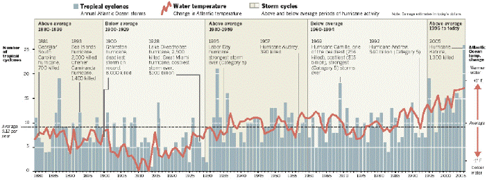
Would you say that shows hurricanes in an oscillation with no trend, or hurricanes rising on a trend?
The answer looks pretty clear to me: the best fit would be an oscillation riding on top of a rising trend. Note the way the last dip of the oscillation barely falls below the last peak, and the current peak is way above the prior peaks. Looks like it's going to be rather challenging developing oil and gas in the GoM for the next decade till we figure out how to do it with regular Cat 4 and 5 storms. Big version of the picture below the fold for those with wide screens.

“To be thrown upon one's own resources, is to be cast into the very lap of fortune; for our faculties then undergo a development and display an energy of which they were previously unsusceptible.”
—Benjamin Franklin
Contact
- Content: editors at theoildrum dot com
- Tech support: support at theoildrum dot com
License

This work is licensed under a Creative Commons Attribution-Share Alike 3.0 United States License.
Note that one of the effects of greenhouse warming is this: as the north polar ice cap melts, it stops one of the key elements of thermohaline circulation which has historically carried vast amounts of ocean heat from the tropics to the arctic.
The large reservior of warm water which now builds up in the Caribbean and Gulf of Mexico leads to larger, more frequent, more powerful storms.
You can right-click the image and "save picture as...", then view with another viewer. The entire image comes across.
http://www.latimes.com/media/acrobat/2005-12/20756378.pdf
Here's the source of the actual LA Times article from which the image originated (NOTE: LA Times requires that you use their free registration to view their online articles):
http://www.latimes.com/news/printedition/asection/la-na-hurricanes1dec01,1,2486171.story
Here's one article.
The waters between the US and Europe have been covered with shipping for centuries. I am from the Liverpool area, and my mother, grandfather, and great-grandfather all worked in the shipping industry. Record keeping was generally excellent by the last decades of the 19th century - passenger lists, crew lists, bills of lading, all significant events during the voyage were logged. Trade between European ports (especially Liverpool) and the US South and Carribean (hurricane country) was extremely extensive because those trade links became established during the slave trade, which was extensively facilitated by Liverpool ships. Sugar, tobacco, cotton both were major imports to Europe from the South and Carribean, and manufactured goods were extensively exported (Liverpool was known as the Cast Iron Shore at one period).
I would be surprised if many major Atlantic storms were not noted and recorded by Victorian society (let alone twentieth century society). And while I don't agree with NOAA's current official position on the cause of hurricane upsurge (which I assume has to pass muster with their political bosses), I do think they've made very extensive and thorough efforts to find and document past hurricanes. I think the low years are low because the basin was quiet, not because of missing data. Here's an example of the kind of data that they has been able to reconstruct for the period of interest (tracks for the first year of the LA Times map). You can see there's coverage of a number of storms that did not make land - even tropical depressions.
Here's 1884 - a quiet year in which nonetheless, two of the known tracks don't make landfall.
And here's 1887, the busiest year in the 19th century.
Sorry for the long comment, but I think it's a very important point.
Add 3 for 2005, and the decade is on track to equal 1931-1940. The eye of Ophelia never quite made land. It probably doesn't mean anything but taking easy 50 year intervals we find 1851-1900 97, 1901-1950 95 and 1951-2000 72.
For the past to be fully represented, there had to be a ship present at the time and in the location when a storm hit max intensity, every time. Not bloody likely. Surely there were hurricanes that only got reported as tropical storms, and tropical storms that got reported as depressions. Also some storms are very short lived. Gaston, last year was only about 3 days, and in times past such a brief hurricane could well have been entirely missed if it didn't come ashore, or came ashore in a sparsely populated area.
To compare with global warming one has to take a world wide view. I have read, but don't have the reference now, that globally there has been no increase in frequency, and that 2005 was not remarkable. Also I read that the Bay of Bengal is always warmer than the GOM this year, but does not produce more intense storms.
I don't think we know enough to draw any conclusions.Murray
1914, 1925, 1929/30, 1939, 1946. Except 1925 each of them can be at least partly explained by a probable drop in shipping. Murray
Anyone care to gather the data?
http://www.junkscience.com/Hurricanes/Hurricanes.htm
http://www.gfdl.noaa.gov/~tk/glob_warm_hurr.html
http://www.ucsusa.org/global_warming/science/hurricanes-and-climate-change.html
As Dot said...someone should run the numbers for hurricanes that have made landfall in the U.S. That should settle it.
Also, I wonder why we never hear of possible correlations (or at least statistical checking) of global warming and typhoon activity. Is it because the Pacific is much bigger with less intensive trade activity (and thus ship crossings) over the past century plus? If not, there should be fairly good data for comparative checking. In any event, surely there's good data for at least the last century. If hurricane hits on the US alone are a valid check, then typhoon hits on Japan, Korea, Taiwan and other North East Asian states would seem a useful comparative stat. Or is there something that makes the Pacific an invalid check?
Unfortunately, for things like global warming and peak oil, nothing is 'proven' until we see it in the good old 'rearview mirror.'
Anybody read Utterback or Christensen on innovation? We are the early adopters. We might test these ideas, but we don't move the market.
My cynical position is that no amount of advocacy will create mass action on GW or PO. It will take an obvious and observable environmental change in each case.
Until then early adopters do a service, no doubt, by trying out possible solutions.
It might be that what we think of as "average" is in fact way below average. As Jared Diamond points out, a cycle that is decades or centuries long ends up being invisible to humans. We assume the way it's been the past few decades is the way it's always going to be. And then are surprised when it changes. We move into the coastal areas during times of low storm activity, then get socked when activity returns to normal. We settled the west during an unusually wet period, then are left scrambling when the normal dry pattern resumes.
However, we may get the straight dope on hurricanes yet. Scientists have found that you can count hurricanes in tree rings:
http://www.physorg.com/news5747.html
It could let us see the hurricane pattern for the past 500 years.
Why do we care whether it's a natural variation or global warming? Because that tells us what, if anything, we can do about it. If it's global warming, well, maybe we can reverse the trend. If it's not, all we can do is get out of the way.
So the LA times may actually have made an interesting discovery by plotting it this way. It seems worthy of further investigation (and NOAA helpfully make the entire track database available online, so we can do so). In particular, I can't help thinking that the prior probability of the Ivan-Katrina-Rita sequence must have been truly miniscule.
What is interesting is that part of this upswing took place during a so-called period of "below average" hurricane activity. It is definitely an interesting thesis none-the-less and I believe it to be a more scientifically rigorous way of measuring hurricane trends.
Another interesting aspect to the study, were the indications that increasing sea surface temperatures (SST) only accounted for part of the increase. The researcher believes the increases could also be due to decreasing vertical wind shear and a potential decrease in the negative feedback cycle of deepwater upwelling after a storm passes. In other words, storms bring cooler, deeper waters up to the surface and decrease the potential for storms in that same path for a brief period of time afterward which accounts for the negative feedback. But since it appears sub-surface water temperatures are in a warming trend as well as the SST, there may be a weakening of this negative feedback.
Check out the short 3-page article for yourselves:
http://www.nature.com/nature/journal/vaop/ncurrent/full/nature03906.html
Here's the abstract:
"Theory and modelling predict that hurricane intensity should increase with increasing global mean temperatures, but work on the detection of trends in hurricane activity has focused mostly on their frequency3,4 and shows no trend. Here I define an index of the potential destructiveness of hurricanes based on the total dissipation of power, integrated over the lifetime of the cyclone, and show that this index has increased markedly since the mid-1970s. This
trend is due to both longer storm lifetimes and greater storm intensities. I find that the record of net hurricane power dissipation is highly correlated with tropical sea surface temperature, reflecting well-documented climate signals, including multidecadal oscillations in the North Atlantic and North Pacific, and global warming. My results suggest that future warming may lead to an upward trend in tropical cyclone destructive potential, and--taking into account an increasing coastal population--a substantial increase in hurricane-related losses in the twentyfirst
century."
What's my point? Trying to look at one noisy climactic phenomenon - hurricanes in GOM - and deduce a signal/trend is unproductive. Rather, a signal of global warming should be crystal clear when many phenomena are scanned and the uncorrelated noise of each is negated. Thus slight ocean current changes + melting of arctic ice + GOM hurricanes + precipitation changes + average temperatures + local changes + ... There must be hundered of measurable and noisy climactic phenomena which taken together ought to be sending a clear - noise free - signal that climate change is happening.
I don't have the skills to corrolate the Data of the Second half of the post.
But my off the cuff guess from all I have read is that We have been heading into a trend. I read Climbing magazines They have pictures of Ice Climbing Routes for the last 80 years, They have Places where the routes were set in with steel anchors in the Ice, these routes and climbing aids are gone. The ice that was there is not there, its edges have moved further up the mountain.
Tree lines have risen, Glaciers have melted or Moved in ways not predicted, Spring time come earlier now in the north country. Reefs dying off becasue the water temps have gone out of their best range. A lot of little things.
Where is the signal in all the data noise? I Don't have a "scientific answer", But my gut feeling is that we are in for a change and it does not matter why it is happening in as much as it is happening. IF man did it, we can't stop it now, its set to motion in a big way and even if we cut the power all off, it would still happen.
14 Hurricanes this season, twice the average.
There is no Plan B.
NEW YORK - Ford Motor Co. is likely to close five plants that employ about 7,500 workers, or about 6 percent of the company's North American workforce, the Wall Street Journal reported on FRiday.
In November, the company announced plans to eliminate 4,000 salaried jobs, or 10 percent of its North American white-collar work force, as part of the larger restructuring plan.
Assume 5 immediate dependents and a worker's $ turns over 7 times in that community.
"* In the long term, the rate of petroleum reserve additions appears
to be falling. As a result, engineering considerations indicate that
world petroleum production will peak in the 1990-2010 interval at
80-105 million barrels per day, with ultimate resources estimated at
2,100 billion barrels."
THE GLOBAL 2000 REPORT TO THE PRESIDENT: Entering the Twenty-First
Century.
A report prepared by the Council on Environmental Quality and the
Department of State. Gerald O. Barney, Study Director.
Penguin, 1982 (?)
http://groups.yahoo.com/group/the_dieoff_QA/message/5318
Courtesy -PeakOil: Life After The Oil Crash
Hopefully the data will be convinceing enought to quiet the skeptics...mabe NOLA as the new Venice?
Here's the story on those predictions. Personally, I don't think these people are looking at the strengthening of tropical Atlantic surface temperatures that Stuart discussed. Because of that, I am wondering if they will be off the mark. Living here in Houston we all constantly marveled at the astounding sea surface temperatures in GOM this year from August through October. Every time we saw a hurricane hit that warm water, my co-workers and I had to consider our shutdown procedures for our data center. And we're all talking about how many times we might have to repeat the evacuation of last year.