Transit-Oriented Redevelopment in New Orleans?
Posted by Super G on January 12, 2006 - 11:17am
New Orleans Mayor Ray Nagin's Bring New Orleans Back Commission has released a master plan for the rebuilding of the city (Powerpoint, PDF courtesy of NPR). Most of the news coverage of the plan focuses on the controversial process that determines which neighborhoods will be rebuilt. But the plan also embraces transit-oriented development and other new urbanist concepts.
I've excerpted some of the key slides and figures below the fold. Do their ideas have merit? Will they ever get implemented?
Transit and Tranportation Action Plan
- City-wide, high speed, light rail transit network connects neighborhoods to downtown and other employment centers.
- Light rail transit creates value and is a catalyst for reconstruction and new development.
- Rail transit links city to the airport, Baton Rouge, and the Gulf Coast.
- New roads will be designed with the wide median (neutral ground) model for pedestrians, bicycles, transit, and open space.
Immediate:
- Repair existing streetcar lines and rolling stock; restore bus service.
- Update plan for transit based on new circumstances.
- Design light rail lines plus rapid transit to the airport, Baton Rouge and the region.
- Secure funding for the rail system.
- Repair and improve streets and associated drainage.
Longer-term:
- Construct connections, jointly with the states of Louisiana and Mississippi, to the airport/Baton Rouge, Slidell, and the Gulf Coast.
- Construct new light rail lines.
- Develop bus rapid transit routes to improve service and connect to high speed, light rail lines.
- As population increases, convert highest use bus rapid transit to fixed rail.
![]()
Bring New Orleans Back Commission Transit and Transportation Action Plan.
Neighborhood Center Model
- Neighborhoods are the centers of activity and daily life.
- Neighborhoods require sufficient population to support the equitable and efficient provision of public facilities and services.
- Every neighborhood must have:
- Basic infrastructure: roads, drainage, utilities, services
- Public schools
- Cultural and community facilities
- Places of worship
- Health facilities
- Park and open space within an easy walk
- Convenience retail
- Access to public transit
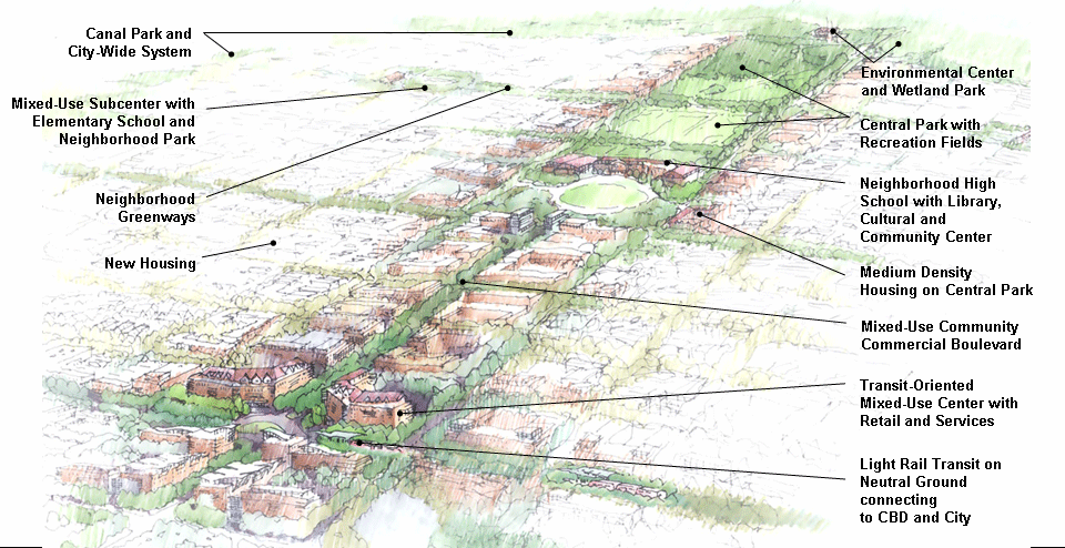
Bring New Orleans Back Commission Neighborhood Center Model.
“I'd put my money on solar energy… I hope we don't have to wait til oil and coal run out before we tackle that.”
—Thomas Edison, in conversation with Henry Ford and Harvey Firestone, March 1931
Contact
- Content: editors at theoildrum dot com
- Tech support: support at theoildrum dot com
License

This work is licensed under a Creative Commons Attribution-Share Alike 3.0 United States License.
I think Mayor Nagin's ideas have a lot of merit, but convincing the money people to go along with them may be difficult, at best.
IMHO, redevelopment, civic life and tourism would all receive a massive boost from the transit and other aspects of the plan. Imagine New Orleans as a tourist destination under this plan!
But I don't think the dinosaurs in DC will want that to happen. Other cities might want the same thing! We'll see columns from Randall O'Toole explaining why everyone should be given a car instead - perhaps so they can all drive away in the next hurricane. He's probably writing one right now. Call me cynical.
I really hope NO is able to get something similar to this through. I don't think the insurance companies will be much of a problem. Most of the city could probably just be condemned. If they can do it to replace working class neighborhoods with high priced condos, they can do it to rebuild a gutted city. But they would have to start now, before people really start the rebuilding process on their own, so rights of way can be purchased and streets can be widen where needed to allow for ped and bike paths, and express bus lanes/light rail.
How well these things are implemented depends on the buying power of the future owners. How well they are maintained and whether they prospers depends on who moves in, and whether they own or rent.
http://news.yahoo.com/s/ap/20060108/ap_on_re_us/katrina_urban_league
Looks like they have only improved the escape routes.
Don't worry there will be no more hurricanes.
Sea temps will drop.
Trans-Atlantic Current will resume to normal.
Pigs will fl.......
As for reconstruction, many are protesting, http://www.commondreams.org/views06/0112-34.htm
Every aspect of Katrina smells of death. Retreating to Baton Rouge, establishing a defense perimiter there (see pics in 1st link) that anticipates meters of future sea level rise, and just compensation for the many displaced seems like the only equitible, longterm solution.
People tend to be too quick to assume that mass transit provides energy benefits. But it shouldn't be surprising that 40 ton electric cars are not that efficient. I guess invisible quality of electric delivery makes it easy to forget that it's real energy.
Power Requirements: 600-900 Volts DC. Requires 288 KWH per hour of operation. Dallas' cars weigh 107,000 pounds and are primarily used in high-speed rapid transit service. They are built by Kinkisharyo.
Houston's Harris County Metropolitan Transit Authority doesn't publish kwh information on their Siemens-Sacramento-built light rail cars. Houston's cars are four tons lighter, so let's assume they are roughly equivalent. Houston's operation is more similar to New Orleans in that the 7½-mile route is entirely street running with more frequent stops than Dallas.
On a weekday, Houston light rail carries about 32,000 riders on 160 round trips, or 320 one-way trips. It takes about 35 minutes for the cars to negotiate the densely-developed route, which is particularly congested through the Texas Medical Center. The cars make thirteen stops. This means that the average rail car carries close to 100 riders per trip. Let's assume the average passenger travels three miles. The cars are almost always used in single-unit operation, the exception being major events like football or baseball games. The cars seat between 64 and 72 persons, depending on whether the seats are raised to accommodate wheelchairs and bicycles. There is room for 98 standees. This means that they have 50% more capacity than Houston's large three-axle buses.
kwh used per one-way trip: 288 X 35 ÷ 60 = 168 kwh
passenger miles per per trip: 100 X 3 = 300
kwh per passenger mile: 168 ÷ 300 = 0.56
Looks pretty efficient to me.
I also don't know what kind of systems they have in Houston and Dallas. Are these commuter lines? Commuter lines are notably quite efficient, because ridership is fairly high and consistent. Diesel commuter trains are very efficient as well. Systems that actually attempt to provide a real alternative to cars, and so have to run longer hours when ridership is less consistent, quickly lose their gain on cars in terms of energy per passenger mile.
Of course, to go the other way, the electricity doesn't usually come from fossil fuels (except coal which is relatively plentiful). So while electricity is not necessarily better than using fossil fuels directly, it is probably better in terms of peak oil, and maybe better in terms of CO2 production.
I'll be first to admit I am not skilled in energy calculations, but I checked your numbers out and they seem correct. Maybe you can help me with this and tell me if I am making a faulty assumption:
Calgary says their cars get "Power consumption (kwh per veh-km of operation) at: 3.23." That comes out to 5.38 kwh per mile. If this were applied Houston on a 7½-mile trip, they would use 40.375 kwh on a 35-minute trip or 69 kwh in an hour. That is a huge discrepancy to Dallas' claim of 288 kwh per hour of operation. If we used Calgary's numbers and applied them to Houston, with 300 passenger miles in the average 35-minute trip, the kwh cost per passenger mile would be only (40.375 / 300) .135 instead of 0.56. That would be equivalent to almost 250 mpg for a 1.1 passenger car.
The Calgary system and Dallas are more similar in that they are mostly reserved railway private rights of way at speeds between stations of 45 - 60 MPH. Dallas has two fairly long lines which together total 45 miles. For all intents these are electric railway commuter lines built to railroad standards but using light rail cars. Stations in Dallas average 1.25 miles apart. The stations are about ½ mile apart near the downtown Dallas area, but the distance stretches to up to 3½ miles in the northern suburbs. Here is a typical view of the Dallas system:

Houston is a street railway operation using light rail cars on a limited tramline concept, where stations are only ½-mile apart on the average and there are another dozen stops for motor vehicle traffic lights. Houston is very much like a streetcar line, other than the fact that the stops are about three times as far apart as those of a traditional streetcar:

Of the two systems, Dallas is much more extensive, starting operation in 1996 with about 20 miles and has grown to 45 miles since then. DART carries about 52,000 riders on a weekday, mostly between the suburbs and town. Vehicle frequencies on each of the two lines is about every 15 minutes on weekdays and every 20 minutes on weekends. There are many park and ride stations.
Houston, on the other hand, opened in 2004, and carries about 32,000 riders on a weekday. It's service is much more frequent, about every 6 minutes on weekdays and every 12 minutes on weekends. Houston's line primarily serves the Texas Medical Center, with 50,000 employees, and downtown, with 100,000 employees. There is only one park and ride station at the south end of the line.
Both Houston and Dallas offer free transfers to intersecting bus lines. Since Dallas is mostly elevated, subway and grade-separated rail right of ways, its speed is much higher than Houston's: 31 MPH versus 14 MPH, including stops. Because of the suburban character of Dallas' light rail versus Houston's urban one, the average passenger trip is much longer.
I just don't understand why Calgary's kwh per mile should yield such a lower energy cost than Dallas' number, since the vehicle weight and operating characteristics are so similar. Here is another source is closer to Calgary's specs, the American Public Transportation Association's 2003 Rail Fact Book:
POWER (miles/kwh)
Automated Guideway 0.16
Cable Car 0.13
Commuter Rail 0.11
Heavy Rail 0.15
Inclined Plane 0.07
Light Rail 0.13
Monorail (a) 0.32
If this is true, then, assuming Houston averages 100 passengers per trip, each traveling 3 miles, a fairly reasonable assumption based on their 32,000 ridership with 160 scheduled round trips, a 7½-mile run would consume 58 kwh, or, divided by 300 passenger miles, .19 kwh per passenger mile. This is higher than the .135 figure above, but much closer to than the .56 kwh per passenger mile I came up with yesterday based on Dallas' data. Your response along with Calgary Transit and APTA's figures makes me think that Dallas' kwh number is way to high.
http://www.nola.com/news/t-p/frontpage/index.ssf?/base/news-4/1131006964300900.xml
The map refferred to in the article is here
http://www.nola.com/hurricane/katrina/pdf/110305/1103A01.pdf
Plaquemines Parish-ROAD OPENINGS AND ROAD BLOCK
A roadblock allowing only parish residents to enter south Plaquemines is located near the the St. Patrick's Catholic Church in Port Sulphur. Anyone wanting to go below this point is required to have a permit from the President or Sheriff's Office.
That's because LA ceases to exist below Port Sulphur.
...in order to save itself from the waters surrounding it, the city of New Orleans is slowly destroying its own environment. The final death knoll of the city may very well come from the river itself. Scientists and environmentalists know that the Mississippi is trying to change its course that will bypass the city in favor of the shorter route to the Gulf through the Atchafalaya basin. So far, the Corps of Engineers has prevented the river from doing this. But, one day, it will happen, perhaps following a direct hit from a hurricane. As late summer and early fall approach every year (hurricane season), New Orleans stands with the threat that it will lose its own lifeline. No canal system and no levee system will prevent the disaster that will follow.
The river is moving away from the city. The city is sinking because of its weight, because no upbuilding by new muck for many decades, because of being cut off from the fresh water, because it is sliding off a cliff (the Continental Shelf), and because the Oil and Gas Industry is extracting oil out from under it. It is a city that for all intents and purposes is now Sea domain.
But the US needs the oil/gas/refineries and the Port so NO will not be abandoned. And the poor will follow the $. Ghettoes will form somewhere.
NO will be an ongoing disaster as a result.
Below is what I just submitted to the paid consultants (WRT Group) for the Planning Subcommittee of Bring New Orleans Back (the mayor's group).
Multi-Use Grand Boulevards Strategy for Revitalizing New Orleans
New Orleans was built around a series of Grand Boulevards during the 1800s, most notably Canal, St. Charles and Esplanade. Space was left on several other streets for more such Grand Boulevards that were never truly developed to their potential.
Picking up where the 19th Century left off, and going forward into the 21st Century with a development strategy that emphasizes a series of modern Multi-Use Grand Boulevards would play to the strengths of New Orleans. The citizens of this city respond far more strongly than most to a premier cityscape. We simply CARE, and deeply, how our city looks and feels.
Taking neutral grounds that are little used today and transforming them into multiuse, multi-modal linear parks would create a powerful attractor for rebuilding New Orleans. And it a concept that many New Orleanians would rally behind. Something better that is truly, fundamentally, New Orleans.
Defining a plan that has near universal support is essential to a planning success in the environment today. A concept that can be easily grasped and quickly create a `That could work' consensus. An idea that has the `Power of a Good Idea' that will sell itself.
A Grand Boulevards Strategy is more likely than any other strategy to create this consensus. Work done for the North Rampart/Desire project, involving Public Works and their experience, can bring costs down closer to European and Australian norms and make these Grand Boulevards affordable. Compared to projects being planned elsewhere with the `Federal Process', a few Grand Boulevards will seem cheap in comparison if built efficiently as was conceived for North Rampart.
Conceptually (but not comprehensively), consider Elysian Fields and Claiborne as two of the first new Grand Boulevards. A bicycle path, separated by shrubs (azaleas, camellias, sweet olive, crepe myrtle, etc.) from the street traffic. Then jogging/walking trails with benches. Inside that two rows of the old style `3 lamp' poles (see Canal Street in the CBD) every 100'. Interspaced in that 100' spacing between the lamp poles are cypress trees (perhaps live oaks on some blocks). And in between the two rows of lamps are 3 streetcar tracks running in grass.
A dramatic, straight vista up Elysian Fields, with the formality of a French garden. And a gentler, curving perspective on Claiborne, with the width varying and the garden blending and moving like an English garden.
But why 3 streetcar tracks ?
Three tracks can blend the attributes of classic New Orleans streetcar service with the attributes of modern light rail development. The outer two tracks provide local service, with stops every 3 blocks. The inner track offers express service in the peak direction with stops every half mile or so. Transit speeds would likely be comparable to the neighboring auto traffic if the streetcars get signal priority. Given the compressed urban dimensions of New Orleans, express service, with stops every half mile and traveling near the speed limit would be time competitive with driving and parking. And each stop would create an opportunity for TOD.
Perhaps, at express stops, small coffee shops could be set up on the neutral ground. Rentals might be another source of revenue for RTA. And these shops could become informal community gathering spots. In the specific case of Claiborne, it may be wise to take two traffic lanes next to the neutral ground (one each side) and transform them into linear park & ride lots or widen the neutral ground in a few specific places. Claiborne will become less like an `auto sewer' repelling people and more approachable.
A narrower, two track Grand Boulevard plan for North Rampart has already received conceptual approval from all significant parties (RTA, the mayor, Vieux Carre Commission, Treme) with the same design elements in just 36' of neutral ground with bike lanes in-street. Given the preliminary work already done, and the variety of different streetcar lines supported by the first half of Desire, this should be a priority.
Overall, this strategy will naturally create mixed incomes within a few blocks of each other, as has happened on St. Charles and Esplanade. New development would be naturally drawn to these Grand Boulevards. Zoning could allow higher density and heights (my preference is a limit of 4 stories in most cases) at Express Streetcar Stops.
West End Boulevard is a natural for another Grand Boulevard, with the additional opportunity that it is wide enough to be raised several feet and accept TOD on the neutral ground. As noted elsewhere, a limited stop express section could be added to West End Blvd. down the partially abandoned railroad ROW 4 blocks downriver of Canal with very inexpensive track on ballast construction.
With some rework, General de Gaulle is a candidate for becoming a Grand Boulevard. Washington can support a narrow, two track `Grand Boulevard' for part of the route as could St. Claude. Almonaster would be an interesting Grand Boulevard in some sections. Napoleon is already a Grand Boulevard in many ways, but it could definitely be enhanced.
Algiers Point has another `Good Idea' that can be inexpensively built. A single track loop around the perimeter of historic Algiers Point using three historic streetcars awaiting renovation in the Carrollton Barn would be an interesting local transportation connection to the Canal ferry and add another tourist attraction to New Orleans.
Concentrating upon a transportation strategy may have an advantage for federal funding. The FTA `New Starts' programs already has a dedicated sum of money and requires no additional appropriations till the six year renewal. Thus, New Orleans needs only get administrative priority over competing projects elsewhere.
In addition, it may be practical to raise the neutral grounds somewhat to create separate polders within New Orleans and thus include Grand Boulevards as part of a flood control strategy.
Good ideas, easily comprehended, filled out with substantial details, are more likely to have a real world impact with the public and the body politic than merely technical recommendations.
Alan Drake
Alan_Drake@Juno.com
I would go as far to suggest that you actively discourage use and ownership of cars within central NO and do what you can to almost force rational humans to use public transport and eschew car use. I know, it is an anathema to 'normal' americans atm, but that will change rapidly in the next 5 years, you have a chance to steal a march on other US cities - take it or die.
28% of residents (not all of them poor) lived in households without one automobile. Many more lived with one car where the American standard would be two (or more) cars.
I am generally opposed to "Park & Ride" as another suggested here. It consumes land (unless uses waste land like underneath our elevated Interstate Highways), it costs money (better used to add more track) and it does nothing for TOD except discourage it.
New Orleans is the best example of "Old Urbanism" design in the US and should be preserved on those grounds alone (there are, of course, many other good reasons).
I would appeal to all that read this to write their Congressperson & Senators and urge BETTER funding for New Orleans. More $ to local gov't and less to FEMA administration. Fund projects and NOT FEMA bureaucrats.
Alan