UPDATED: Cantarell and Questions Regarding Mexico's Oil Infrastructure
Posted by Sam Foucher on August 21, 2007 - 8:00am
Scroll down for the 5:00p and 11:50p EDT updates.
Hurricane Dean became a Category 5 storm last night with winds reaching 165 mph and reaching a low pressure of 909 mb (as of 2:15a EDT; Katrina was 920 mb and Camille 909 mb). Landfall occurred early yesterday morning with a second landfall occurring some time today. This is an historic hurricane by any standard.
Why this matters: If there were Cat2 winds in that area, we could have been talking about around 2.5 million barrels per day of Mexico's supply capacity being shut in for a while, and some of that shut in for an extended amount of time. Around 1.5 mbpd of that capacity is exported to the US (of the 20.5 mbpd the US uses, and the 85mbpd the world uses, each day). There are also some questions about the resilience of refineries and flow lines in the area of the second landfall.
Update (Khebab, 11:50 EDT):
HURRICANE DEAN ADVISORY NUMBER 35A
...DEAN IS MOVING BETWEEN THE WEST AND WEST-NORTHWEST NEAR 20 MPH...32KM/HR...AND THIS GENERAL MOTION IS EXPECTED DURING THE NEXT 24 HOURS. ON THE FORECAST TRACK...DEAN IS EXPECTED TO BE VERY NEAR THE COAST OF CENTRAL MEXICO DURING THE DAY WEDNESDAY. MAXIMUM SUSTAINED WINDS REMAIN NEAR 80 MPH...130 KM/HR...WITH HIGHER GUSTS. DEAN IS A CATEGORY ONE HURRICANE ON THE SAFFIR-SIMPSON SCALE. AN AIR FORCE PLANE IS CURRENTLY APPROACHING DEAN. SOME RE-STRENGTHENING IS FORECAST DURING THE NEXT 24 HOURS.
HURRICANE FORCE WINDS EXTEND OUTWARD UP TO 35 MILES...55 KM...FROM THE CENTER...AND TROPICAL STORM FORCE WINDS EXTEND OUTWARD UP TO 140 MILES...220 KM. ESTIMATED MINIMUM CENTRAL PRESSURE IS 970 MB...

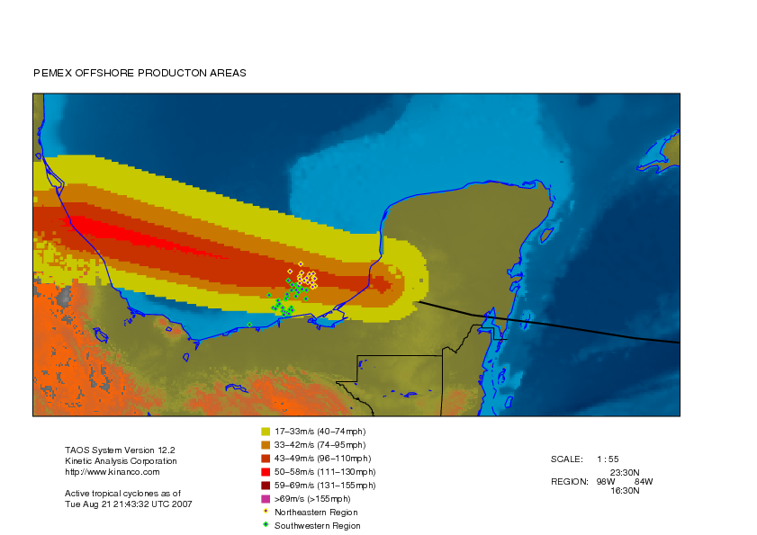
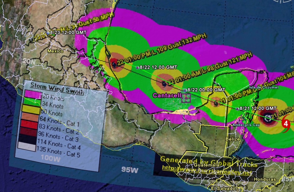
Cantarell and KMZ oil complex, 50-knots wind speed probabilities (NHC, forecast #35). Click to Enlarge.

Refinery position, 50-knots wind speed probabilities (NHC, forecast #35). Click to Enlarge.
More under the fold.
UPDATE FROM CHUCK WATSON at 5p EDT, 8/21
Chuck Watson of KAC/UCF has just released his damage estimates. Here's what he has to say:
NHC has dropped their intensity more in line with our estimates. I'm sticking with the earlier damage forecast - Southwestern about 10 days, Northwestern (Cantarell etc) 15 to 18 days, unless something unlucky happens like a critical component failure. So our total shut in forecast from this event is around 30 million BBL, which was at the low end of my earlier model. The storm decayed more than the NHC estimates.
Under the fold (click "there's more" below), we are going to try to bring together some of our information we have gleaned to this point. We ask that you post all stories, insights, links, maps, and other tools in this comment thread. If you have stories or insights you wish to share, please also feel free to use the editors' box to contact us.
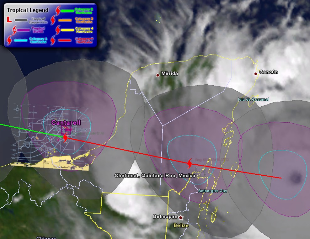
Cantarell and KMZ oil complex, forecast track and wind strength distribution (the purple area is at least tropical storm winds, blue is category 1 winds) from last night's run (21:00 UTC). Click to Enlarge.

A category 5 can make this kind of damage on landfall:
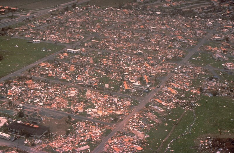
Hurricane Andrew (1992), category 5, a whole Miami neighborhood is
leveled..
Forecast track possibility along with "spaghetti models" from yesterday night run (21:00 UTC). Click to Enlarge.

Cantarell and KMZ oil complex and 50 Knot (58 mph) Wind Speed Probabilities - 120 Hours from yesterday night run (red to purple means probability > 70%). Click to Enlarge.
Wind distribution. Click to Enlarge.

QuickSCAT wind field. Click to Enlarge.
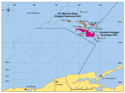
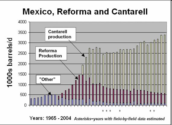
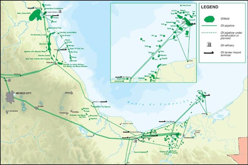
What is the area we're worrying about? Cantarell and KMZ, as said above, PEMEX is shutting down ~140 rigs and moving 13,000+ workers on land. Cantarell + Ku-Maloob-Zaap account for 66% of the total oil production of PEMEX in June 2007. Cantarell alone is 47% of the total....and here's the best pic we have (right click and view image to see full size):
***
The United States imported approximately 620,000,000 barrels from Mexico last year. (http://tonto.eia.doe.gov/dnav/pet/hist/mttimusmx1m.htm)
More on importers (Mexico is the 2nd ranked importer (at 1.5 MBPD) to the US behind Canada in 2007, then comes Saudi Arabia): http://www.eia.doe.gov/pub/oil_gas/petroleum/data_publications/company_l...
The IEA on Mexico: http://www.iea.org/Textbase/country/m_country.asp?COUNTRY_CODE=MX
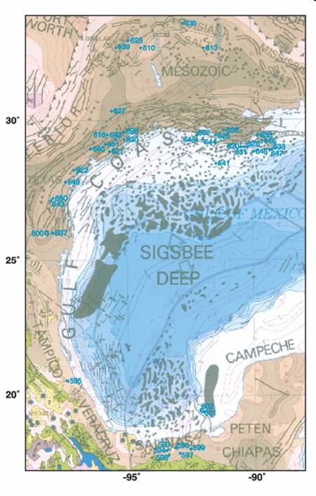
Google maps of the Bay of Campeche: http://maps.google.com/maps?ie=UTF8&om=1&z=7&ll=19.849394,-94.163818&spn...
***
Khebab posted "An Update on Mexico's Oil Production--The Rapid Collapse of Cantarell by the Numbers"
Last year, I expressed my concerns about the eventual impact of a rapid collapse of Cantarell on Mexico's oil production (story here). The last production numbers from PEMEX seems to confirm the rapid decline of Cantarell as well as the inability of the Mexican to rapidly bring new production online. The Wall Street Journal (thanks to Jerôme) published an article on Cantarell last week:
The virtual collapse at Cantarell -- the world's second-biggest oilfield in terms of output at the start of last year -- is unfolding much faster than projections from Mexico's state-run oil giant Petroleos Mexicanos, or Pemex. Cantarell's daily output fell to 1.5 million barrels in December compared to 1.99 million barrels in January, according to figures from the Mexican Energy Ministry.
***
Euan Mearns put some flesh on the bones of Mexican oil production here (discusses the KMZ area very nicely and has a couple of nice maps too.)
Following on from Khebab's posts (Jan 2007 and July 2006) I wanted to put some production geology flesh on the bones of Mexican oil production. The main points I want to make are:
1. Forecast production decline of 14% per annum in Cantarell sounds alarming but it is in fact the result of planned reservoir management.
2. The forecast decline of Cantarell is due in part to the diversion of nitrogen injection from Cantarell to the neighbouring Ku-Maloob-Zaap (KMZ) complex of fields. Production at KMZ is forecast to rise to around 800 MBD and this will partly offset production falls at Cantarell.
3. Cantarell / Mexican production is predominantly heavy crude, and it is postulated that any production declines in Mexico may be met by additoinal production of Saudi Arabian heavy crude forward to 2012.
4. Notwithstanding point 3, Mexican oil production decline means that 4 out of 5 major OECD producers are now in decline (Norway, UK, USA and Mexico), leaving only Canada with growing production and this presents the OECD with a growing problem of energy security.
5. The Hubbert Linearisation (HL) for Mexico reflects reservoir management (gas lift and nitrogen injection) and new field developments but the interpretation remains equivocal. A brief description is given of why Pemex have used gas lift and nitrogen injection to boost production at Cantarell.
***
Luis de Souza put together this analysis of world oil exports for Mexico
Mexico is here assessed to be capable of producing a total of 50 Gb to 2075, giving a midpoint of depletion in 1999, some fourteen years after what appears to be a premature actual peak in 1985. Production now stands at about 3.2 Mb/d, being subject to a fairly high depletion rate of 5% a year.
Mexico seems to have peaked only in 2004, but the future decline rate is maintained.
***
Ace also does some work on Mexico on his Updated World Oil Forecast.
***
All TOD Work on Cantarell and Mexico
http://www.theoildrum.com/tag/cantarell
http://www.theoildrum.com/tag/mexico
***
Mexican Oil reserves:
http://www.ruf.rice.edu/~leeman/MexOilReserves.gif
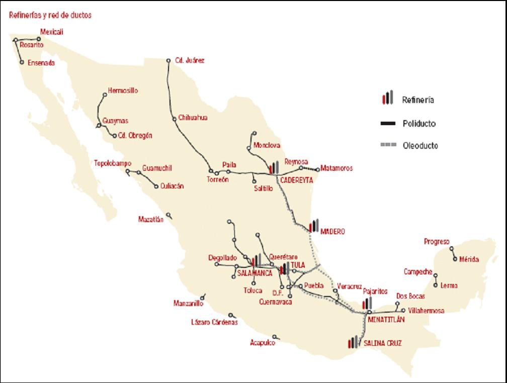
Mexican refineries:
http://www2.nrcan.gc.ca/es/es/NA-enrgpic2006/rpImages/5-04-e.gif
***
Some PEMEX background:
http://en.wikipedia.org/wiki/Pemex
http://en.wikipedia.org/wiki/Cantarell_Field
Here's a list of refineries:
* Minatitlan Refinery (Pemex) 170,000 bpd
* Cadereyta Refinery (Pemex) 292,000 bpd
* Tula Refinery (Pemex) 320,000 bpd
* Salamanca Refinery (Pemex) 236,000 bpd
* Ciudad Madero Refinery (Pemex) 190,000 bpd
* Salina Cruz Refinery (Pemex) 320,000 bpd
***
More from PEMEX on KMZ: http://www.pemex.com/files/content/ACFWVNY7kO2v.pdf
***
Almost Total Cantarell Evacuation
Mexico clears oil rigs as hurricane nears
Might order total well closureMexican state oil company Pemex on Sunday evacuated thousands of oil workers from the Gulf of Mexico and warned it might close up to 2.2m barrels a day of crude oil production as the powerful hurricane approached.
Pemex said it was evacuating 13,360 workers – most of its workforce in the area - and that it might order the ”total closure of the oil wells” in the Cantarell oil field and other fields.
http://www.ft.com/cms/s/0/96593284-4e46-11dc-85e7-0000779fd2ac.html
***
This is from the EIA Hurricane analysis for 2007, showing historical production of oil and gas from the Outer Continental Shelf of the Gulf of Mexico.

Oil production seems to be about 1.4 million BPD; natural gas appears to be about 7.5 billion cu. ft. per day.
***
And then some charts and maps and such:

Update (Khebab, 11:55 EDT)
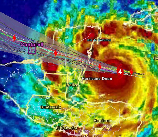
Hurricane Dean is a clone of Hurricane Janet (1955) who emerged in the gulf as a category 2:
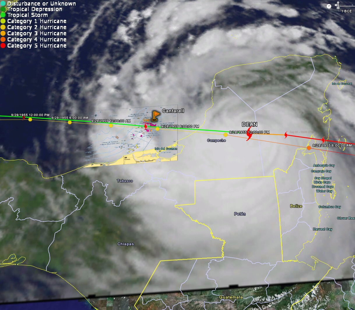
Cantarell and KMZ oil complex, trajectories of Hurricane Dean and Janet (colored circles). Click to Enlarge.
Contact
- Content: editors at theoildrum dot com
- Tech support: support at theoildrum dot com
License

This work is licensed under a Creative Commons Attribution-Share Alike 3.0 United States License.
Latest(10PM CDT) forcast track shows projected direct hit on Cantarell 7PM Tuesday.
http://www.nhc.noaa.gov/refresh/graphics_at4+shtml/203526.shtml?3day#con...
it seems that earlier predictions that land would slow the hurricane to below hurricane level winds may have been mistaken. This will be the FIRST landfalling Cat 5 in 15 years (Andrew) and a strengthening one at that. As of 12:45 EST NWS is stating it will re-enter Bay of Campechi as Cat2, which certainly will damage some of those old rigs...methinks the market has now overreacted in its underreaction
It'll hit Cozumel head on.
http://en.wikipedia.org/wiki/Cozumel
Cozumel has 75k people on it, its 12 miles to the coast, and the high point on the island is 15m. How much storm surge is expected with a 914mb core pressure? Is the tide in or out?
I am suddenly feeling a little sick and wishing I hadn't Googled that ...
It's going to hit far south of Cozumel. It is actually aimed directly at the capital of Quintana Roo, Chetumal.
I was looking at an older path projection. Sorry for the excitement ...
Winds down to 80 mph, making it a very low strength hurricane. Details can be found at http://www.weather.com/newscenter/tropical/?from=wxcenter_news
Again, as I mentioned on all the other threads, the sheer distance the hurricane had to cross over land would knock this hurricane down tremendously. It'll be lucky to reach a category 2 hurricane before hit makes landfall a second time. Seems like the worst is over.
What are the odds of a DIRECT HIT on Canterell at the worst possible time for the US?? Canterell may not recover. Why rebuild it if its in terminal decline? Just let whatever's left get the oil out at whatever rate it can....
Let's see here....2005 GOM oil production smashed, yet to recover fully....now Mex production smashed......Me thinks the odds are tooooo great for this to be coincidence..
I am trying not to think about the fact that there's no way the folks built those rigs to withstand Cat 2 winds in the Bay of Campeche.
But I am also trying not to think about the human toll of this storm. It absolutely wrecks me.
Professor,
I'm digging now trying to get current information on Dean. Did it actually cross Cozumel? Do we know exactly when? If the tide was in and its a 914mb storm the island is only 45' tall at its highest. How much storm surge comes with pressure like that?
If this came to pass at high tide Cozumel could very well be Mexico's New Orleans. There are 71,000+ permanent residents and if they can't have evacuated all of them.
-SCT
It hasn't made landfall yet. The recon just measured 905 mb.
Where can we get current position and speed, preferably with a map of the area? The tracks I've seen so far put it going right over the top of San Miguel.
Oh, and Wikipedia says they took a direct hit from Wilma in 2005 - took the top 5' off every tree, ruined the sewers, basically scrubbed the island bare. And now they'll be getting it just as bad, if not worse, and that is before knowing if they'll be taking storm surge, too.
Lets hope their government is more competent than ours at dealing with such events.
Best place to look is easternuswx.com or wunderground.com (Jeff Masters' blog). They're the real weather geeks and they're talking about this all night, guaranteed.
Fly the flag a little whereever you guys go. We need news tips on this story, especially on those rigs and infrastructure.
Cozumel 20.30' 86.57'
Dean 2100 GMT 18.2' 84.2'
Dean 0300 GMT 18.4' 86.0'
Dean 0900 GMT 18.6' 87.8' (estimate)
Closest approach estimate 0800 GMT (as I post) - 1.75' x 1.25'- roughly 2 degrees or 138 miles? No surge, no eye, but still quite the mess.
It is possible that many of the older rigs (drilling rigs) have not been designed to withstand a high category hurricane. However most of the newer production facilities (production platforms and FPSO) on the KMZ field have been designed to withstand cat. 5 hurricanes (100 year hurricane).
http://www.offshore-mag.com/display_article/295832/120/ARTCL/none/VESSL/...
Similarly moored installations remained in operation through both hurricanes Rita and Katrina. Although production will be shut in for a few days as a precautionary measure, production should be up again within 24 hours of the hurricane passing.
Older installations on the Cantarell field will clearly be affected to a greater degree.
I've found once a hurricane is big that the best predictor of its future intensity over water is the TCHP:
http://www.aoml.noaa.gov/phod/cyclone/data/go.html
While it's a foregone conclusion that it will wallop the Yucatan, once reduced over land it may not strengthen much over the Bay of Campeche, based on the TCHP. Of course that's not to say that it won't be strong by the time it reaches Cantarell...
_FT, LEX column, Aug 10, 2007
I would think that the government has a pretty good incentive to fix what it can.
http://science.reddit.com/info/2h52g/comments
http://digg.com/business_finance/Cantarell_Now_Directly_in_Hurricane_Dea...
We need your help folks. Spread this around, please.
From the NHC forecast update (02:25 EDT):
DROPSONDE DATA FROM THE AIR FORCE RESERVE HURRICANE HUNTER AIRCRAFT
INDICATE THAT THE MINIMUM CENTRAL PRESSURE IN THE EYE OF HURRICANE
DEAN IS NOW 909 MB...26.84 INCHES.
As if things could not get worse...
same as Camille. Yeesh.
Looking at the satellite loops it's uncanny how both arms of Dean remain over water - the northern one slotting through the gap. So even though it's got to navigate through Yucatan it might be hardly diminished. Surely the most severe hurricane that could possibly hit Cantarell.
"Waves On The River Of Mind" -- graffito outside local hamburger joint.
From the 2 am NHC advisory:
REPEATING THE 200 AM EDT POSITION...18.5 N...86.8 W. MOVEMENT
TOWARD...WEST NEAR 20 MPH. MAXIMUM SUSTAINED WINDS...160 MPH.
MINIMUM CENTRAL PRESSURE...911 MB.
Since then, Dean has continued to intensify, with a pressure of 909 mb just measured - the 9th lowest ever measured in the Atlantic basin. Landfall is imminent.
If we assume the worst and there is heavy damage on the rigs (I sincerely hope that there won't be any damage), what kind of repair timeframe could we be looking at? I mean how long do repairs on these things usually take?
Ignore me if this is too speculatory.
Hurricane Dean is really something. It made landfall a little before 8am GMT as a cat 5 – the first Atlantic basin storm to do so in 15 years since Andrew in 1992. The minimum pressures are likely to make this a “10 ten” storm. Who knows what’ll happen over the next 12 hours as it transverses the peninsula but seeing as the oil infrastructure is right on the forecast path and the storm made landfall as powerful as it did and is moving quite fast I’d say this is as bad as it could be for Cantarell and KMZ.
Hello TODers,
I sure hope they keep flying those Hurricane Hunter planes into Dean to fully instrument the 'cane crossing the Yucatan. I am insanely curious to see if Dean intensifys over land like Andrew '92 did in FL, and how far it gets before it starts to lose strength and intensity. Then if it does any re-intensification before clearing the Yucatan, then finally how much and how quickly it re-intensifies before it hits Cantarell & KMZ. Time will tell soon.
If the eastern landfall is just North of Chetumal: the storm surge of 12-18 ft, plus waves on top, plus 5,10,20 inches of rain could really saturate this area with warm water to further power the 'cane. As can be seen by this maplink:
http://images.google.com/imgres?imgurl=http://www.vivanatura.org/Yucmap3...
and a better geological relief map here:
http://ambergriscaye.com/pages/town/mapreliefbay.html
On the Eastern side: there is a huge estuary or bay that can can be overrun by this surge and then the seawater can be pushed quite a bit further inland if the surrounding land is under 20 ft above mean sea-level. Could this be miles inland? The cane rotational winds will fill this bio-reserve with stormsurge and the escape route for this water will probably down thru Chetumal Bay, instead of a quick flowback to the sea. My guess is that this storm surge will also be encountering huge floods of warm rainwater flowing down from higher locations. All potential fuel for the storm as the winds whip the heat out of these frothy, foaming waters. Not as good as hot, deepwater ocean, but it might be sufficient enough to keep Dean from degrading in intensity and size quickly on the overland traverse.
Notice from the map that a similar bay or estuary exists on the western side where Dean will be exiting into BoC. This can be another source of heat to help keep Dean strong over its land traverse if the feeder bands or eyeball bands can extract any energy from this area before finally clearing into the GoM proper.
Of course, the biggest factor is Dean's areal size. Does it have the 'oceanic suckage' to keep sufficiently sized feeder bands and eyeball bands pumping energy into the 'cane as it traverses land? From the latest satellite-animation maps showing Dean just offshore: by my eyeballing Dean appears big enough to basically fill the land traverse with the eyewall outer bands, and the feeder bands swirling in from the GoM, Yucatan Slot, and the Caribbean seem to be long and thick. All good signs to help Dean slowly degrade instead of petering out over the Yucatan. I am still speculating CAT 3 at Cantarell/KMZ, but I sure wish I could find a highly detailed topographical map of Dean's Yucatan traverse path.
Feel free to refute or embellish as desired, my fellow TODers.
Bob Shaw in Phx,Az Are Humans Smarter than Yeast?
Bob, the reason that Andrew, and some other Florida landfalling hurricanes retain much of their strength as they cross the penninsula is because of the numerous warm fresh water lakes and rivers in Florida. Also, storms maintain strength in Fl. after a rainy episode across the state that causes large amounts of standing water. My wife and I have been victims of these phenomena on numerous occasions.
Hello TODers,
To add further proof to my theory: please examine the infrared bloom that explodes off from the small bay in the western Yuc, and also the rapid expansion of the southside and northside infrared bloom when the eyewall of Dean first starts sucking the heat out of Chetumal Bay and the bio-reserve [northside of Dean] estuary south of Tulum.
http://www.weather.com/maps/news/atlstorm4/atl4satellite_large_animated....
This was from 6:00 to about 8:00 GMT if the animation auto-updates. Also notice if the eyewall tightens and shrinks as Andrew did when it got over land. Recall my earlier NOAA documented posting on this phenomena please.
Bob Shaw in Phx,Az Are Humans Smarter than Yeast?
If I recall correctly, hurricane hunters will not fly into a hurricane that is over land. There is too much turbulence. They can still measure the intensity of the hurricane accurately enough using land-based measurements.
Hello Chris,
Thxs for the history book footnotes. I just read the 4am NHC update:
----------------------
REPORTS FROM AN AIR FORCE HURRICANE HUNTER PLANE INDICATE THAT THE EYE OF DEAN MADE LANDFALL ON THE EAST COAST OF THE YUCATAN PENINSULA NEAR COSTA MAYA OR MAJAHUAL AROUND 330 AM CDT. THIS LOCATION IS ABOUT 40 MILES...65 KM...EAST-NORTHEAST OF CHETUMAL, MEXICO.
----------------------
If Dean keeps its 20 mph speed, just how much time will it take on the overland traverse? I figure the distance from Majahual to Champoton [south from city of Campeche and on the shoreline] as 200 to 220 miles; ten or eleven hours overland. Thus: 3:30 + 10 = 1:30 pm or 3:30 + 11 = 2:30 pm when it finally reaches the first waters of Campeche Bay. Does that sound about right, or does someone have a better calculation than me?
Bob Shaw in Phx,Az Are Humans Smarter than Yeast?
Per NOAA 4AM CDT Report central pressure just before landfall was 906 mb.
Just browsed the mainstream media reports on Dean. They are reassuring investors that Dean will do minimal damage to Mexico's oil fields but say nothing of the lost oil production off the world market.
This is what the BBC are saying this morning:
I don't get it, 2.7mbpd is shut in for at least a week, the most powerful hurricane to ever hit the the area is approaching... seeing as the oil infrastructure is right on the forecast path and the storm made landfall as powerful as it did and is moving quite fast I’d say this is as bad as it could be for Cantarell and KMZ. Can the old Mexican infrastructure withstand the likely Cat 2 hurricane tomorrow?
Even without any damage I would have expected more response from the market from the lost production alone.
As mentioned in an earlier post, much of the infrastructure on KMZ certainly can withstand a Cat. 2 hurricane as it is designed for Cat. 5. And as Mexico now is shifting most of its production from Cantarell to KMZ by transferring injection wells, KMZ is actually more important than Cantarell for future oil production. This is the reason for the calm oil markets. The infrastructure is far newer than that off the South US coast line that was heavily affected by Katrina and Rita. I predict that Mexican oil production will only be disrupted for a short period of time. However, I may of course be mistaken. My greatest worry is not the oil-production but the lives of the people in the path of the hurricane.
Those poor people in Quintana Roo. Its one of the very poorest parts of Mexico, very Indian, subsistance farmers and fishermen.
www.weatherunderground.com predicts that it will emerge as a category 2. The older platforms likely will have some damage, the most destructive may be to the pipelines. i doubt they are buried very deep in the bay mud, and if they are broken all the wells further out will be offline reguardless of whether the rigs are damaged
Most of the offshore workers likely live in areas which are being heaily affected with rain and winds near the bay of Campeche, the roads may not be passable for them to get to the boats to get them back to the rigs before Thursday or Friday, and the same with the seamen on the crewboats. We won't have any real idea about the true damage until early next week.
After Rita we had shortages of gasoline for a couple of days in the Houston area. There was no damage or electricity shortages, but all the tank truck drivers had evacuated with their families in the runaway scrape of an evacuation, plus the refinery workers to put the gasoline in the trucks. And I expect they will have the same in the Campeche area. You can expect those men to take care of their families firstbefore they get back to work, so it will be early next week before they get out there and survey the damage.
I seem to recall that, after Katrina, there were quite a number of offshore platforms that were not rebuilt, because it was not economical (too little oil remaining vs. cost of repair).
So, if older facilities are both more susceptible to damage and less likely to be repaired, that begs the question as to how much oil is being produced by older rigs.
Does anyone know whether this info is available?
Critical Mind
Those were mostly gas production platforms that't weren't rebuilt after Katrina, rather than oil. Gas declines a lot quicker. As I noted, i think it will be next week before the reports of permanent damage filter in. Pemex won't be able to even do a visual survey by helicopter until at least Wed. Afternoon and probably Thursday, too rough. Bob Ebersole
Bob,
Is there a good primer out there on what goes on in an oil/gas field for those of us who've not worked in the industry. My guess regarding the above statement is that natural gas is more easily recovered simply because it isa gas - no need for water or nitrogen injection to raise it, but it would be nice to have a resource that explains that stuff for we laymen.
-SCT
Note up under the header graphic "Tech Talk"...all of that is HO's sets of primers on extraction and such.
Venezuela Oil Shipments
I noticed that a BIG feeder band of Dean was centered on Lake
Maracaibo Venezuela. I do not expect damage, but it seems that loadings (to all destinations) and shipping to the USA from Venezuela may well have been disrupted for several days.
A small factor in the overall picture, but less heavy oil for all.
Alan
They ship a lot to the Lyondell-Citgo refinery in Houston. They're will be a big drawdown in crude stocks in the Gulf Coast.
I'm just worried about all those poor fishermen along that coast. With gusts up to 200mph everythings gone-houses, boats and god knows how many lives. Those are the kind of people who are too poor to evacuate without help, it may be worse than New Orleans, the winds and storm surge certainly are
Bob Ebersole
Hello TODers,
Anybody found a good topo-map of the Yuc yet?
This is the best I found so far, but it is just a map of streams to creeks to rivers:
http://edcintl.cr.usgs.gov/iabin/images/yucatan_srtm-level2_synthetic_st...
It sure would be nice to know how steep or level the lay of the land is with a true topo-map. IF the land is real level: imagine these flows not moving downstream much, just getting real wide, real quick from rain and storm surge. Hell some of these rivers will run upstream or backwards from the storm surge, making them incredibly wide, real fast.
From the map, it is easy to see the two bays or estuaries on the opposite sides of the Yucatan. This is pretty close to Dean's overland traverse route. It will be interesting to see after this is all over if many streams will be forced into new streambeds, or if even new islands or small inlets are carved out along the eastern seashore. Who knows?
Bob Shaw in Phx,Az Are Humans Smarter than Yeast?
Based on photos it's completelly flat and sandy, with tourist buildings right in the beach.
This is supposed to be ground cero:
Hello Ilex,
Thxs for the photo. Yikes!: No place to run, No place to hide--I sure hope anyone near the eyewall tried to put as much distance as possible between themselves and Dean as early as they could. I would not even trust my life in the orange building in the photo, and it looks fairly substantial.
Bob Shaw in Phx,Az Are Humans Smarter than Yeast?
I've been there. Those substantial building you see are just the tourist trap for cruise ships. They built a pier for the ships and a walled in area containing all the colorful buildings you see there to sell things to tourists. No one lives there. There is a fishing village (well formerly a fishing village, I'm sure it's mostly cruise tourist income now) about 2 miles south called Majahual. That's where the people live. Or lived.
That's the way it used to look, anyway. Probably no longer as of a few minutes ago.
If you have the bandwidth, pull up Google Earth. It gives altitudes at the bottom of the screen. The peninsula is not entirely flat. In my quick perusal last night some areas go from sea level to 20m pretty quickly. There are areas in the center in the 200 - 300m range.
So there should be places to get away from the storm surge (if you can afford transportation). There didn't look like a lot of buildings that I'd trust against Cat 5 winds. There was a picture of a nice little beach hut right in the path. Certainly history by now.
When it comes to hurricanes their is a certain logic to preferring a grass shack over a wood frame or cinder block construction.
If you live in a grass shack you assume it's toast, take any valuables with you when you evacuate and then rebuild when it's done.
With the "modern" building you resist evacuation because your "stuff" is there. Finally give in and throw some of the most valuable in your car. You return to find the rest of your stuff destroyed and you look forward to months of living in a hotel or with relatives while you wait for the insurance company to tell you how much they'll cover.
If Mexican production stays down for much time at all, it will give us a better clue about OPEC's and especially KSA's spare capacity. Their standard claim is that the markets are well-supplied, so they don't have to increase production. With a loss of 2.7 mbpd, it will be difficult for them to continue to claim the world is well-supplied. (Although in Sept '06 they had offered to increase production by 2 mbpd if anyone asked but claimed no one asked, they then seemed to forget that offer when Bodman asked them to increase production this summer.)
On another note, I just heard Capital One has closed down its mortgage division:
http://www.sfgate.com/cgi-bin/article.cgi?f=/c/a/2007/08/21/BU22RM3LF.DTL
I totally agree. After 9/11 with no planes for three days we got good information on the effect contrails have on surface temperature. Two weeks of 2.7M barrels offline will tell us much about what the rest can do in terms of capacity.
Oh, contrails? 1.5 degrees cooler during the day and 1.5 degrees warmer at night due to moderation provided by the extra cloud cover.
A look at the NHC shows that Dean will likely be a Cat 1 or Cat 2 when it passes over Cantarell due to weakening as it passes over the Yucatan.
Nevertheless, about 2.5 million b/d is already shut-in and will be offline all this week and likely for another week or so after that. There will be some damage in the oil fields but the extent of that will not be known for a while. There is low probability that the shut-ins will last longer than I've said here due to that damage.
The oil markets are bearish because Dean missed the U.S. oil & gas infrastructure. I ascribe this to America-centrism and a fundamental ignorance of market fundamentals (exports). There is also myopia and an inability to comprehend global oil supply tightness. If we draw from stocks, an already deteriorating situation can only get worse, perhaps much worse. Yet, traders can not think things through this far.
How can we explain the importance of declines at Cantarell when price-setters can not respond to its entire production being shut-in? (even if it's temporary)
8AM - DEAN DOWNGRADED TO CAT 3 - 125MPH WINDS
Looking more like CAT1 out the other side now.
Dave,
America-centric, surely you jest, isn't in the Bible that Branson, Missouri is the center of the universe?
(sarconal alert)
I suspect that shut ins will mainly depend on pipeline damage. If they are dragged around the way that pipelines were during Katrina and Rita, its going to shut off all the wells upstream of the damage until they are at least pressure tested Does anybody have a pipeline map? How deep is the water-as I recall, pretty shallow. Bob Ebersole
My guess is that traders aren't reacting for a couple of reasons. They have been preoccupied with the financial storms of last week, storms usually peter out over land and Cantarell getting hit by a hurricane hasn't happened before. They aren't good with new happennings...
Can't help but wonder what the political/economic fallout of a serious hit on Mexico's oil/gas/elec. might be. Their prez is leaving the summit in Canada early to deal with Dean's impact, and he's already got problems with the border, drugs, etc.
Wallstreeters seem to be singing the LaLa song with fingers firmly jammed in their ears.
Mexico is an interesting export case history. Their initial decline in net exports, from 2004 to 2005, was 9.7%. My Export Land Model (ELM) suggests that the net export decline rate should accelerate with time.
If Mexico's consumption from 2005 to 2006 had increased at the same rate that it increased from 2004 to 2005, their net export decline rate from 2005 to 2006 would have been 10.2%, as predicted by the ELM.
However, their consumption fell from 2005 to 2006--presumably because of the falloff in cash transfers back home from Mexican workers in the US (probably because of the decline in housing construction)--and their net export decline was only 1.7% from 2005 to 2006.
Note that Mexico was the only top 10 net exporter in 2006 to show a decline in consumption.
Dave, I used to have a place on the beach down in Mexico, a Cat2 usually does no damage that can't be swept up in a couple of hours.
There is no incentive to exaggerate the damage down there, so people just fix it.
One would imagine an oil rig to be a little more solid then a shack on the beach. It's usually a logistics issue, but the oil company has resources.
Other watches:
92L is unorganized, may not develop, but too early to stop watching.
http://hadar.cira.colostate.edu/ramsdis/online/trop_ge_vis_float2_0.html
Experimental(92L):
http://www.nhc.noaa.gov/gtwo_atl.shtml
http://www.nhc.noaa.gov/text/refresh/MIATWDAT+shtml/211205.shtml?
The other wave (not Invest'd yet) at 40W, is looking very good for development.
http://cimss.ssec.wisc.edu/tropic/real-time/wavetrak/winds/archive/wavet...
Also, in that image you can see a huge wave getting ready to BELCH off of Africa.
I haven't seen any discussion on Dean's likely impacts to the electric grid serving the Campeche area and the Yucatan Peninsula. Is the Mexican grid strong enough to shrug off a direct hit from a powerful hurricane? It is certainly in the realm of possibility that even as a Cat 3 storm Dean could wreak havoc on the southern Mexican grid, and disable parts of the Cantarell/KMZ complexes for weeks if not months.
Friedrich Schiller: Against stupidity the gods themselves contend in vain.
All offshore rigs have diesel generators, but the tank farms and the pumping stations on land would depend on the grid . The refineries are on the weak side of the storm on the mainland, but the power generating stations likely depend on natural gas from offshore. Refineries in the US all have back-up generators, and so do loading docks for oil in ports.
Dean is still on land in the Yucatan, its a little early to worry about specific damage. I need to state that any speculation I make is just that, speculation. At this point I'm sure we can all telephone the city of Campeche, its probably got only cloudy skies and some heavy showers.
Bob Ebersole
The nitrogen plant at Cantarell (located just onshore and southwest of the field) has its own electric generating plant (fueled by natural gas directly from Cantarell). This was done because the local grid could not supply sufficient amounts of electricity for the plant.
I don't know, but wouldn't be surprised if the nitrogen plant's generators can't be fed INTO the grid, providing energy not only for the plant but also for the several refineries and other infrastructure located on land immediately around the nitrogen plant.
If you look at the Google Earth mashup, there is a ship at abou 27 15'N and 64 56'W (due south of Bermuda) that was reporting 46mph winds and 13 ft seas.
from wunderground.com:
Rank Hurricane Season Min. pressure
1 Wilma 2005 882 mbar (hPa)
2 Gilbert 1988 888 mbar (hPa)
3 "Labor Day" 1935 892 mbar (hPa)
4 Rita 2005 895 mbar (hPa)
5 Allen 1980 899 mbar (hPa)
6 Katrina 2005 902 mbar (hPa)
7 Camille 1969 905 mbar (hPa)
8 Mitch 1998 905 mbar (hPa)
9 Dean 2007 906 mbar (hPa)
10 Ivan 2004 910 mbar (hPa
5 out of the 10 storms there formed in the past 4 years
Hello TODers,
10 day weather forecast for Mexico City is lots of rain and thundershowers. Recall that Dean is headed this direction. Will the Big Drain be up to the task?
EDIT: forgot the link to weather.com
http://www.weather.com/outlook/travel/businesstraveler/tenday/MXDF0132?f...
Bob Shaw in Phx,Az Are Humans Smarter than Yeast?
Hurricane Dean is now halfway across the Yucatan, will be across this afternoon. While Dean is significantly degraded, he has a huge windfield and is drawing in moisture and energy from the Gulf of Mexico, the Pacific, and the Caribbean.
From NHC 11 am advisory:
REPEATING THE 1000 AM CDT POSITION...19.0 N...89.6 W. MOVEMENT
TOWARD...WEST NEAR 20 MPH. MAXIMUM SUSTAINED WINDS...105 MPH.
MINIMUM CENTRAL PRESSURE...950 MB.
From 11 am NHC discussion:
AFTER MAKING LANDFALL IN A SPARSELY-POPULATED AREA...DEAN CONTINUES
TO TRAVERSE THE SPARSELY-POPULATED SOUTHERN PORTION OF THE YUCATAN
PENINSULA. THE EYE HAS FILLED AND CLOUD TOPS ARE WARMING. THE
INTENSITY IS ESTIMATED AT 90 KT BASED ON THE DECAY COMPONENT OF THE
SHIPS MODEL. DEAN IS EXPECTED TO EMERGE INTO THE BAY OF CAMPECHE IN
ANOTHER 3 TO 5 HOURS AS A HURRICANE...AND WILL HAVE ABOUT 18 HOURS
OVER WATER TO REGAIN STRENGTH. SHIPS AND GFDL GUIDANCE SUGGESTS
THAT DEAN COULD APPROACH MAJOR HURRICANE STATUS AGAIN...ALTHOUGH
THE AMOUNT OF RESTRENGTHENING WILL BE HARD TO GAUGE UNTIL WE SEE
HOW MUCH OF THE INNER CORE OF THE HURRICANE SURVIVES ITS PASSAGE
OVER LAND.
The Oil Drum gets a shout out today at the Washington Post discussion on the hurricane
http://www.washingtonpost.com/wp-dyn/content/discussion/2007/08/20/DI200...
Dean has to travel about 200 miles across the Yucatan today, so about a 10 hour overland trip. Hopefully, it will all but kill the hurricane. I'm betting it will be a borderline tropical storm as it emerges in the gulf.
The good news - probably little or no damage to oil and gas infrastructure.
The real issue now is when can Pemex start up operations again? Pemex 80% shut down for 2 days or more seems like a relatively big deal to me.
Jeff Masters expects it will be a cat 2 with 100 mph winds when it exists Yucatan
At last check it was a category 2 hurricane with 105 mph winds, but still hours away from the gulf. By now it may already be a category 1 hurricane.
Thx for the link. That was a good interview. Meteorology is certainly more interesting than just the 8 oclock news.
Khebab wrote:
Actually, as far as the oil markets are concerned, it's been a consistent and growing yawn since Sunday evening (EDT) when they first opened overseas for trading after the weekend.
TOD vs. the oil traders.
There will an interesting post mortem in any event.
Compared to what's happening in the credit markets, Dean is a side-show.
T-Bill rates had their largest one-day drop ever yesterday, and have been cut in half since Thursday (from FT behind pay wall):
In that sort of cash squeeze and rush to quality, a sell-off in oil futures should not be a surprise. If you're a "player" still afloat, then what do you sell to meet your margin calls:
A) Asset Backed Securities (of any flavor), which have no buy quote on your screens?
or
B) NYMEX Crude contracts, on which you may have lost money but there's a liquid market ongoing?
In the last few hours yields have been rising again:
http://finance.yahoo.com/q/bc?s=%5EIRX&t=5d
Equities are stable. In the past 24 hours some markets like Tokyo have continued to rally nicely.
Bloomberg links the fall in oil directly to Dean's sputtering.
http://www.bloomberg.com/apps/news?pid=20602099&sid=ayVjJCKSRZec&refer=e...
I don't doubt, as bloomberg also says, that general oil softness is linked to subprime fallout, but oil traders are still following that storm like hawks and they ain't scared.
^IRX closed at 3.42% - not exactly flying, still up .42% from yesterday
but for perspective, from Jan 1 to end July was essentially 4.40%-5.05% - and closed 4.80% on Aug 8, day before the roof fell in
for real T-Bills:
3 month issue 8/02 @ 4.825
3 month issue 8/23 @ 2.850
Cash is it these days, and we may see oil be depressed not for supply reasons, but rather unwinding of some of the past year's speculation
It is also interesting to note that the contango position of oil has been reversed, with long futures prices sloping down from front month - last summer, long futures were sloping up (which some people - to use an FT term - thought was a symptom of money market folks speculating in the oil patch)
from bloomberg:
U.S. Three-Month Treasury Bill Yields Climb Most Since 2000
Their front page adds the words: "....As Lure of Safety Wanes"
http://www.bloomberg.com/apps/news?pid=20601087&sid=a71TmD923UUA&refer=home
I really can't see how one can make the case that the fall in oil today is the result of panic selling on account of liquidity issues that trump the huge threat of Dean. Things are calmer than they have been in a while.
It really does look like Dean is a wash. Anyhow, damage reports will be available soon.
I've been to the Yucatan many times. It is essentially flat with scrubby trees on a limestone base. If you climb to the top of any of the Mayan pyramids you can see for miles. That's the high ground.
The reference and photo up top about the Hurricane Andrew's destruction is hardly a way to measure this. Beyond the Mayan ruins, most structures down the peninsula are barely half as solid as a typical Miami tract house. Chetumal may be the capital of Quintana Roo, but it's a backwater by American standards. And it sits very low.
http://chetumal.com/sights/chetbay
Well, we'll just have to see about how the concrete blocks hold out.
When TOD posters talk about evacuation, I think most people are thinking about American-type highway arteries. Forget it, not down there. Except for the one big road up to Cancun, everything else is like a U.S. county road...and much more poorly maintained. I've had to dodge many potholes inland between Tulum and Valladolid at a top speed of 25 mph. If trees are down and low areas flood, IMO no one is going anywhere. This is a terrible event.
The morning news coverage out of NYC media outlets is fretting about the TOURISM infrastructure, not oil. Just goes to show you where the priorities are for most people.
All that said, I love Mexico and will be traveling to Morelos State next week for a retreat.
UPDATE FROM CHUCK WATSON at 12:40 EDT
Chuck Watson of KAC/UCF has just released his damage estimates. Here's what he has to say:
We may see a microcosm of WestTexas' Export Land Model here. Mexico will be down much of their oil production for a week at least, more if there is significant damage from the hurricane. I would guess that they would use what production they have to satisfy their domestic market, while exports to the U.S. would suffer. Thus, if they have a drop of 30 million barrels, it may all come out of exports to the U.S. That would drop our U.S. crude stocks from 335 million barrels to 305 million barrels over the next month or so, if all other factors were static. This would begin to show up in the weekly inventory numbers maybe beginning as early as next week, but the week following that for sure.
Ok. So we have a pretty good idea of where Dean is going to hit, and how strong it'll be, and what the production shut-in will be, due to just precautionary closings, etc. We know approximately how many mbd will NOT be making it to the US this week. The markets are acting like it won't matter, but the numbers say otherwise.
Can anyone put this info together with the most recent crude inventories stats by region and give us an educated guess as to the impact at the pumps?
That is, should I be calling my relatives in Denver or Atlanta or California and telling them to top off their gas tanks now?
In regard to topping off gas tanks, nope.
Any short term shortfall in crude oil production can easily be made up from the SPR.
However, in the medium term a continuing question I have about the offshore production is what might happen to the undersea flow lines, which were heavily damaged in 2005 in the Gulf of Mexico.
In any case, longer term Mexico is following the Export Land Model, with declining net exports. If it were not for the decline in consumption from 2005 to 2006, Mexican net exports probably would have dropped by double digits from 2005 to 2006.
This is the first hurricane to make landfall for the season ... and its a category 5 ... right through a sensitive area.
The Atlantic basin has as much energy as 2005. There is already another proto-storm aimed at the east coast.
http://www.wunderground.com/tropical/tracking/at200792_sat.html#a_topad
I think this is a year for gas in cans as well as topped off tanks.
Not much of a "running start", that one.
September has traditionally been the deadliest month. Anything coming off of Africa over the next 4-5 weeks would be cause for worry.
WT,
Glad you brought up the SPR. There's every reason to believe; short of major interruption to Cantarell; that the US supply will barely ripple since we'll simply dip into the SPR. Granted the calculable "missing barrel" numbers are impressive, and Dean's path sure couldn't be worse for the Cantarell area.
Having said that...
1. The various calls on KSA up-thread are IMO misplaced. The Kingdom can plausibly call this a non-event for them precisely because we have the SPR. We won't call their bluff. Short-term gas prices are more influential than any desire for knowledge of the King(dom)'s state of clothing. Collusive behavior comes to mind. That is, suppose they are indeed approaching dire straits; they don't want to show their depleted hand, and we don't want to force their hand. No conspiracy; just basic human behavior.
2. Ever since I drank the PO-Kool Aid, I've held a belief that we will inexorably drain the SPR as a result of exactly this sort of one-off event. Rinse. Repeat. And when the nut cuttin' really comes, we won't have much of a cushion left. System resilience comes to mind.
Ed
Hmmm...Thought experiment: will a monotonic decline in SPR levels presage a PO-watershed?
The SPR is 330 Mbbl and we use 21 Mbbl/week. (Is Mbbl the right way to say that? I'm new here and not from the industry ...)
Cantarell's input to the U.S. is 1.5 Mbbl. If its offline two weeks we lose 21 Mbbl. Assuming we are indeed past peak oil what are the effects of restocking the SPR? We're already going to be watching what happens with OPEC to see if there is spare capacity ... is there also going to be signal in the manner in which the SPR is refilled, or is this an opaque process?
There are 690 million barrels in the SPR. You can track the status of it every week at this link:
http://tonto.eia.doe.gov/dnav/pet/pet_stoc_wstk_dcu_nus_w.htm
It has been unchanged for some time now.
Thanks. I went looking for that. Silly me to think that the data would be at http://www.spr.doe.gov/.
Cantarell going down short term is a non-event for gas prices. Much more interesting will be to see the recovery of flow rates.
Best Hopes for Good Rig Design & Engineering,
Ed
In 1995 when Roxanne took Cantarell off-line Mexico still met export commitments by drawing down on domestic inventories.
Is the size of the Mexican domestic reserve known? In fact, is there some resource that aggregates that information for all petroleum producing countries?
I would look at the posts linked above as well as ASPO's monthly reports. Mexico was a few months back I think.
what are the effects of restocking the SPR?
Uh'mm
We don't.
At least this Administration. Katrina draws still not replaced.
Bid 4 or 5 tines, all bids "too high".
Alan
Alan,
I looked at the history here:
http://tonto.eia.doe.gov/dnav/pet/hist/wcsstus1w.htm
And I don't see any big changes in 2005. Sure, a ten million barrel move, but on a seven hundred million barrel reserve that isn't really that much. Is there something I'm missing?
-SCT
Katrina was a minor draw on the SPR, to below authorized limits. But GWB, Cheney et al cannot seem to find the money to refill it (guess where the $ from the K sales went ?)
Alan
Poorly advised adventurism masquerading as foreign policy?
We don't.
At least this Administration
SPR began this administration at 541 Mbbls
Its now at 690 Mbbls
In the previous administration it began at 575 Mbbls
The main draws during that administration were in the second half of 1996 and 2000, election years, I'm shocked!
GWB did add oil when oil was cheap, but has still not replaced the Katrina draws 23 months later.
I do not think that Clinton was as Peak Oil aware in 1999 & 2000 (his last years in office, oil about $15-$20) as Dick Cheney is.
I have no knowledge of what the VP has told the incumbent POTUS.
No Hopes for GWB & Cheney,
Alan
Expect a SPR draw in the comming weeks:
We will have to wait for [Aug. 22] before knowing if Dean has caused any damages to the Mexican oil assets upon entry into the Bay of Campeche."
Hurricane Dean had strengthened into a Category 5 storm with 165 mph winds when it made landfall Aug. 21 near Majahual, Mexico, at 4:30 a.m. EDT. Moving west-northwest at 20 mph, Dean was expected by evening to reach the southern Bay of Campeche where the state oil company Petroleos Mexicanos has 66% of its oil production. Pemex reportedly evacuated more than 14,000 workers from 140 offshore facilities and has shut in production of 2.65 million b/d of oil and 2.63 bcfd of natural gas.
The US government said it is prepared to make emergency oil loans from the Strategic Petroleum Reserve to US refineries to help offset any loss of Mexican crude. Mexico was the third-largest oil supplier to the US in May, after Canada and Saudi Arabia.
Roger from the Netherlands
This may have already been posted, but the latest figures out of Mexico show continued decline in production, down 1.9% June to July and down 16% Y/Y. . .
http://www.bloomberg.com/apps/news?pid=newsarchive&sid=aJenGUuX0n7A
Interesting to me that they have actually been able to increase exports during that time, as I am a believer in the ELM.
They showed a small decline in net exports from 2005 to 2006 (1.7%), following a 9.7% decline from 2004 to 2005. It would have been a double digit decline if their consumption had increased at the same rate as 2004 to 2005, instead consumption fell from 2005 to 2006, presumably because of a decline in cash transfers from the US to Mexico by Mexican workers (because of the decline in housing construction).
BTW, I think that Pemex is reporting gross exports, not net (I think that Mexico imports some refined products).
In any case, even with the decline in Mexican consumption (the only one of the top 10 to show a decline), the top 10 net exporters showed an increase of 500,000 bpd in domestic consumption in just one year, from 2005 to 2006.
I think that depends on what OPEC does - or doesn't do - next month. I believe it would be a mistake to view Dean's impact in isolation from other world events. We still have a war going on remember.
Sorry if this question has already been posed, I have asked it on drumbeat also.
Jeff Masters at Wunderground this morning states
"The only hurricanes on record that survived crossing this portion of the Yucatan and maintaining hurricane intensity were Hurricane Roxanne of 1995, which hit just south of Cozumel as a Category 3, and emerged near Campeche as a Category 1; and Hurricane Janet of 1955, which hit near Chetumal as a Category 5 storm, then weakened to a Category 2 storm when it popped out into the Gulf of Mexico south of Campeche."
Was Cantarell functional in 95, did it sustain damage then?
Quick google says yes.
http://www.google.com/search?hl=en&q=Hurricane+Roxanne+Cantarell
Here's a PDF report from 95
http://omrpublic.iea.org/omrarchive/08nov95sup.pdf
Who knows what has been changed or upgraded though.
This is interesting. From the November 1995 IEA report:
Dean is now a mid-level cat 1 hurricane with maximum sustained winds of 85 mph and may weaken a bit more before heading out into the gulf. It isn't going to significantly damage the oil and gas infrastructure.
Cyclone Gonu now seems like a decent point of comparison - effectively shut down Oman's oil exports and disrupted shipping for a few days.
Dean represents a potentially a more significant, but very short term disruption of Mexican oil exports.
...meaning the oil speculators called it pretty much right, as of a couple hours, oil still off slightly....by the way, what happened to our market link to yahoo futures?
RC
Given the rate that the peninsula has weakened it, I'd expect Dean to have maximum sustained winds of barely hurricane strength, maybe 75 mph, by the time it hits open water again in 2 hours or so. It's also slowed down to about 18 mph, giving it a bit more time over land.
The yahoo charts were frozen on 10 AUG at Yahoo...no idea why.
They might begin to restart facilities tomorrow. Another glitch in the OECD 3rd qtr builds.
Dean is down but not out.
From the 5 pm NHC advisory:
REPEATING THE 400 PM CDT POSITION...19.4 N...91.3 W. MOVEMENT
TOWARD...WEST NEAR 20 MPH. MAXIMUM SUSTAINED WINDS...80 MPH.
MINIMUM CENTRAL PRESSURE...970 MB.
From the 5 pm NHC discussion:
DEAN HAS EMERGED INTO THE BAY OF CAMPECHE. THE ADVISORY INTENSITY
OF 70 KT IS AGAIN BASED ON TYPICAL DECAY RATES...AND HIGHLY
UNCERTAIN. AN AIR FORCE RESERVE UNIT RECONNAISSANCE AIRCRAFT WILL
BE IN THE CYCLONE AROUND 00Z TO ASCERTAIN THE TRUE STRENGTH OF
DEAN. BASED ON SATELLITE IMAGERY...THE INNER CORE OF DEAN APPEARS
TO BE LARGELY INTACT...WITH DEEP CONVECTION DIRECTLY OVER THE
CENTER. THIS IS EXPECTED TO ALLOW RESTRENGTHENING TO BEGIN FAIRLY
QUICKLY...AND DEAN COULD BE VERY NEAR MAJOR HURRICANE STATUS BY THE
TIME OF ITS LANDFALL IN THE WESTERN GULF.
This gives some appreciation of the magnitude of the event, and our thoughts should be with the folks down there:
Dean Bears Down on Mexico´s Oil Industry
Tuesday, August 21, 2007 - 09:08 PM
By MARK STEVENSON
Associated Press Writer
FELIPE CARRILLO PUERTO, Mexico
Hurricane Dean swept across the Yucatan peninsula Tuesday, toppling trees, power lines and houses as it bore down on the heart of Mexico´s oil industry. Glitzy resorts on the Mayan Riviera were spared, but vulnerable Mayan villages were exposed to the full fury of one of history´s most intense storms.
President Felipe Calderon said no deaths were immediately reported in Mexico, after Dean killed 13 people in the Caribbean. But driving rain, poor communications and impassable roads made it difficult to determine how isolated Mayan communities fared in the sparsely populated jungle where Dean made landfall as a ferocious Category 5 hurricane.
Dean weakened over land but was expected to strengthen as its eye moved over the Bay of Campeche, home to more than 100 oil platforms and three major oil exporting ports. The sprawling, westward storm was projected to slam into the mainland Wednesday afternoon with renewed force near Laguna Verde, Mexico´s only nuclear power plant.
"We often see that when a storm weakens, people let down their guard completely. You shouldn´t do that," said Jamie Rhome at the U.S. National Hurricane Center. "This storm probably won´t become a Category 5 again, but it will still be powerful."
At 5 p.m. EDT, Dean had winds of 80 mph and was centered about 60 miles west-southwest of Campeche. The storm was moving west at 20 mph, the National Hurricane Center said.
While 50,000 tourists were safely evacuated from resorts on the Yucatan peninsula, many poor Indians closer to the storm´s direct path refused military orders to leave their homes, according to Gen. Alfonso Garcia, who was running shelters in Felipe Carrillo Puerto, 30 miles north of the eye´s path.
Troops evacuated more than 250 small communities, and 8,000 people took refuge in 500 shelters, said Jorge Acevedo, a Quintana Roo state spokesman. Others turned away soldiers with machetes and refused to leave, but some of them changed their minds when the winds and rain intensified, he said.
Little was known about the thousands who rode out the storm in low-lying communities of stick huts or the handful who hid from soldiers evacuating smaller resorts like Majahual, where Dean made landfall with 165 mph winds and gusts of 200 mph _ faster than the takeoff speed of many passenger jets.
Mexican officials said they were making slow progress down nearly impassable roads to reach these places. In less isolated towns, people emerged to survey toppled trees and downed power lines crisscrossing flooded streets.
"If only the government would lend us a hand," said Georgina Hernandez, 59, whose three children all lost their homes in the town of Los Limones.
Dean´s path takes it directly through the Cantarell oil field, Mexico´s most productive. The entire field´s operations were shut down just ahead of the storm, reducing daily production by 2.7 million barrels of oil and 2.6 billion cubic feet of natural gas.
Insured losses from the storm are likely to range between $750 million and $1.5 billion, according to Risk Management Solutions, which calculates hurricane damage for the insurance industry. Most of that came in Jamaica, which said Tuesday it was postponing Aug. 27 general elections to survey the damage.
Dean hit Mexico early Tuesday along a sparsely populated coastline, well to the south of major resorts. The brunt of the storm struck the state capital of Chetumal, where residents spent a harrowing night with windows shattering and heavy water tanks flying off rooftops. Sirens wailed for hours as the storm battered the city, hurling billboards down streets. The Federal Electricity Commission said 90,000 customers remained without power by midday.
Electricity was also out to most of Belize, where no deaths or major injuries were reported. Just south of the Mexican border in Corozal, Dean flipped a residential trailer, blew roofs from homes and flooded streets.
The latest forecast put the storm on target to hit land again Wednesday afternoon at Tecolutla, a coastal river town about halfway between Tampico and Veracruz. The area is an oil industry hub, dotted with derricks and pipelines on land and home to many of the workers who maintain seven oil platforms a half-hour helicopter ride offshore.
That´s 400 miles south of Texas, where only heavy surf was expected. The space shuttle Endeavour landed a day early Tuesday because of the threat NASA had once feared Dean would pose to Mission Control in Houston.
North of Veracruz is a strip of resorts known as the Emerald Coast, and seven more oil platforms are just offshore. Laguna Verde, Mexico´s only nuclear power plant, is only 35 miles to the south, and hundreds of buses stood by to evacuate workers if necessary.
Calderon cut short a trip to Canada so he could travel to the hardest-hit areas. President Bush, standing by his side at a summit in Montebello, offered U.S. aid.
"We stand ready to help," Bush said. "The American people care a lot about the human condition in our neighborhood, and when we see human suffering we want to do what we can."
Dean was the third-most intense Atlantic hurricane to make landfall since record keeping began in the 1850s. It had a minimum central pressure of 906 millibars, the third-lowest at landfall after the 1935 Labor Day hurricane in the Florida Keys and Hurricane Gilbert, which hit Cancun in 1988.
"A very low pressure indicates a very strong storm," said meteorologist Rebecca Waddington.
The deadliest storm to hit Latin America in modern times was 1998´s Hurricane Mitch, which killed nearly 11,000 people and left more than 8,000 missing, most in Honduras and Nicaragua.
___
Associated Press writers contributing to this report included John Pain in Miami; Richard Jacobsen in Poza Rica, Mexico; Karla Heusner Vernon in Ladyville, Belize; Lisa J. Adams in Mexico City; and Michael Melia in San Juan, Puerto Rico.
Other than the remarkable fact that the oil price went down after 2.5 million barrels per day of oil was temporarily shut-in, Hurricane Dean appears to be a non-event.
The real lesson here is what the market did. The value of the commodity (oil) is more and more divorced from its actual value. This does not bode well for our world because it will be more business as usual when the oil price falls. Yet another excuse for OPEC to do nothing.
Ultimately, I believe the market signal over the longer term does demonstrate peak oil, but the signal is not strong enough to prevent the inevitable crisis. Complacency or panic. And for now? The former. Later (when)? The latter.
Dave, two things are happening, right now, investors are unwinding highly leveraged bets on rising oil prices, selling oil to make up for a loss of liquidity caused by the credit crunch and a failure to raise money on the money markets. The reason funds area able to sell it so quickly and well is because the market for oil is sustained. It may therefore be more of a case of how much this hurricane tempers the unwinding, which may have some way to go before bottoming out.
"Nobody needs to go anywhere else. We are all, if we only knew it, already there." (Aldous Huxley "Island" 1962, p38)
I think you're trying to pronounce a post-mortem after one day's worth of short-sighted trading by participants perhaps diverted by greater cash concerns.
Can anyone tell me more about the image:
HERE
Origin? Have better resolution? It's a good image.
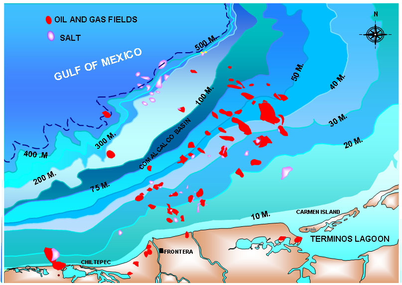
If I seem to recall properly, Rita and Katrina both caused non-trivial problems with detached pipelines and silt. I see a lot of susceptible pipelines in that image.
Watching the weather channel, it appears to me that there is an eye forming directly on top of Cantarell. If as Prof Goose fears, those rigs were not built to withstand Cat 2 winds in the Bay of Campeche, well that's another set of problems.
Back to that image, there appears to be another cluster of oil infrastructure blobs on the coast where H. Dean is set to make his second landfall perhaps as a Cat 2-3. According to an article above, this may well be "Tecolutla, a coastal river town about halfway between Tampico and Veracruz. The area is an oil industry hub, dotted with derricks and pipelines on land and home to many of the workers who maintain seven oil platforms a half-hour helicopter ride offshore."
It seems to me that the crude market may have totally misunderestimated the impact of this storm on global crude supplies in the weeks-months type of term. I don't know how open Mexico and PEMEX are with their data, and we may not know until after the fact just what went down.
I found that in a search...I believe the terms were "Mexico refinery", Mexico refinery list, and/or Maps of Cantarell.
I will do some digging...I did the searching from my other machine ... can't get to that until tonight.
That was the best resolution I could find. There's also another flash map that was good too in one of the other threads...ah, here it is...
http://www.pemex.gob.mx/index.cfm?action=mapa
A very cool map...forwarded from an industry insider. (it's Flash, so I couldn't paste it.)
Thanks for the reply Prof. Goose. I couldn't find the same map, but I've been comparing what I've found to that one. It is almost certain that the oil infrastructure blobs on the Veracruz coast there are around Tuxpan.
See This Map for example.
Seem to be multiple
refineriespower plants in Tuxpan too.Last I'm hearing is Tuxpan for the second landfall.
Mexico's coastal oil infrastructure is going to be put to the test.
There is a pretty detailed interactive map of Mexico at INEGI (Mexican geography agency):
http://galileo.inegi.gob.mx/website/mexico/viewer.htm?sistema=1&c=423&s=...
(it is in Spanish)
Select the layers you want to display. Among them are electric lines and pipelines (under the heading "Generación, Transmisión de Energía y Conductos").
I have a geoTIFF 1:250,000 scale topo map of the Veracruz region with location of electric and oil infrastructure but I don't know how to upload it (and it's ~5.2 Mb).
email it to me at the eds box GeoMex...I'll put it up.
I'm sure there's going to be more than idle curiosity tomorrow morning about the state of Pemex's 'region noreste.' Markets will react if there's damage or delay in turning the tap back on.
Right now, it looks as though Dean's reformed eye is already west of Cantarell.
Mexico City is in a lake bed right? This one looks like it's headed towards Mexico City. Any guesses what happens when this thing decides to unwind and release a couple million tons of water in central Mexico? Read Roar of The Heavens by Stefan Bechtel.
whoa
Tony
Hello TheMouse,
I have first posted info on this months ago, but here is a more recent newslink:
http://www.bloomberg.com/apps/news?pid=20601086&sid=a4otVGXRyL04&refer=l...
----------------------------------------
Sewage Spill Looms as Mexico City Mayor, President Cast Blame
Millions in Path
A failure in a single section of the main drainage canal could flood 210 square kilometers (80 square miles) and require the evacuation of 4 million people, according to an Inter- American Development Bank report.
``The question is not whether a catastrophe is going to happen, but when is it going to happen again,'' said Exequiel Ezcurra, former head of Mexico's National Institute of Ecology.
--------------------------
On another topic, if I was the Mexican President: I would make sure aid & security & electricity is restored first in the towns where the oil-workers reside, so that they would feel confident in leaving their families to more quickly commute back to the offshore platforms and other infrastructure areas.
Bob Shaw in Phx,Az Are Humans Smarter than Yeast?
Remember Mexico city is at 2,400 m above sea level and has a volcanic range to the east (e.g. Popocatepetl and Iztaccihuatl) exceeding 5,000 m asl.
When the remnants of Hurricane Camille in 1969 slammed into the Appalachian mountains of Virginia, 800 miles from the point of landfall, the water was squeezed out of the atmosphere and dumped 30 inches of rain in less than 8 hours. So you are just supporting my concerns.
The Valley of Anáhuac, where Mexico City lies, is a natural lake bed that has no natural drainage, except that made by mankind. Camile was a Cat 5 hurricane. Large hurricanes have LOTS of water vapor. At the rate Dean is moving it will hit the central valleys of Mexico within 36 hours, and being forced upward by the mountain ranges, will dump a tremendous amount of rainfall in a very short amount of time.
Tony
Hello TODers,
I would imagine it would be top-secret, classified, top-level only, Pemex executive and Mexican govt info, but couldn't a military spyplane be flying around Cantarell and KMZ right now taking detailed radar and infrared imagery of the offshore structures? A quick, but thorough analysis would reveal how many structures might be listing or sunk, or moved off-position, or maybe how much rigging and other equipment is twisted and inoperable. Any TODer expertise on this subject? Or do they have to wait until the 'cane passes, then do eyeball examinations only with helicopter and/or plane flybys?
Also, wouldn't pressure sensing equipment for the undersea pipelines show an immediate drop in PSI if Dean has wrenched them loose from the seafloor?
EDIT: Are military analysts allowed to have personal brokerage accounts to play the stock and futures markets? Imagine the coin you could make if you had detailed, early inside info even 2,4,6,12,24,36,72 hours ahead of the crowd when the official reports are released.
Bob Shaw in Phx,Az Are Humans Smarter than Yeast?
...analysts allowed to have personal brokerage accounts...
It's called insider trading. An "insider" is anyone who has real data or can manipulate an event and trade on it [take a position] before most others know the info. It is not necessary for the insider to have any connection with the company to learn the data or manipulate events. But you probably know this already.
Arkansawyer
Last week's inventory was released early.
Just a mistake...
There's been mistakes/confusion/something
with every inventory report since Memorial Day.
I'll start looking for action at 9:15 AM C.
Just to be sure.
When one uses the information you might have with the knowledge you are talking about and even if you lost money on the marketing of such knowledge the jail time is still 10 years and up. And that nasty label you get for the rest of your life. Traitor.
Seeing that there might be several highly placed Government officals which will remain nameless, who have or might have been trading with their own knowledge of things happening or might be happening. I'd hope that in the grand scheme of things they would also get labeled like us lower class flunkies.
Looks like abcnews.com did some homework regarding oil and nuke infrastructure to be hit next.
http://abcnews.go.com/Technology/WireStory?id=3507451&page=3
Everyone keeps commenting that the "Oil Market" doesn't understand what's going on.
The fact is, an amazing amount of contracts are trading by momentum daytraders who don't know crap about the oil industry.
I did the math, and just today only, and just for 2 Exchange Traded Funds (USO, UNG), the total dollar amount of the transactions was, get this:
$307,207,721.60
The people buying and selling this stuff today probably have no idea what a Ghawar or a Canterell is and most likely don't care.
This is what the OPEC bulletin keeps saying month after month. The price movement is not based on fundamentals but rather speculative interests.
That's why I sold my oil positions yesterday. If CNBC tells the sheep that all the oil wells are spared, then that's what they're going to believe. You can bet against it if you want, but you're going lose your money. Other the other hand, tomorrow when CNBC says Canterell is trashed and we'll never see another drop of oil again as long as we live, it'll rocket to the moon.
This is what scares me about the upcoming OPEC meeting in Sept. What happens if the popular meme becomes OPEC can't meet demand?
Well just have to send more economists out to make large discoveries.
Arkansawyer
But that's just it.
CNBC will go down before it admits "Canterell is trashed and we'll never see another drop of oil again as long as we live".
The importance of oil can be seen in every watershed event of the last 100 years.
But you'll never see the word "oil" mentioned.
Almost the same with wheat production.
BTW, this area of Mexico also produces alot of it's corn.
Australia's output may be between 14 million tons and 23 million tons, the analysts and traders said today by telephone and e-mail. Yields are at risk from dry weather, with less than 40 percent of average rain in most growing regions this month.-Bloomberg
That's approximately a 10 million ton haircut along
w/ the just released 2 million ton shortfall in world
production.
The NYMEX and ICE exchanges are the tail that wags the USO stock, not the other way around -those markets are much much larger, though still not huge. And the NYMEX traders very certainly know what Ghawar and Cantarell are - and they will be buying with both fists once things start heading up permanently.
A CBS morning financial show mentioned Dean & Cantarell by name and listed various US refineries (with b/day) that use Mexican oil. They said it was uncertain how long production would be shut in. They also said that the supply chain was vulnerable to even small disruptions.
That said, I am under-impressed by the wind speeds and storm surge from Dean yesterday and this morning. Little damage results from 95 and 100 mph winds (I have been through these), and evenly moderately hardened facilities can withstand 120 mph winds.
However, oil facilities are very complex and a single break in the chain stops production (the two oil export terminals on the East Coast of Yucatan seem quite vulnerable if not hardened). And steel structures exposed to salt water for 25 years are rarely "as designed".
My *GUESS* is a group of small problems that reduce Mexican oil production and exports below last week's levels for a month or more, but significant production and exports within a week. I would prefer a slightly bigger problem as a wake-up call.
Alan
http://www.ndbc.noaa.gov/show_plot.php?station=42055&meas=sght&uom=E
anyone see this wave height buoy data near Cantarell.
That's a rocking and rolling.
FF
FF,
This is why I keep mentioning the flow lines.
With the SPR, we can easily handle a disruption of Mexican exports.
However, what is interesting is that we may have to dip into the SPR. It once again shows that emergency reserves have emerged as the new "swing producer," because there is no excess crude oil productive capacity worldwide.
http://news.xinhuanet.com/english/2007-08/22/content_6579323.htm
Hurricane Dean will paralyze oil extraction in Mexico
www.chinaview.cn 2007-08-22 04:16:49
For those with no background in oceanography, the graphic in FF's link shows "significant wave height", defined as the average height from peak to trough of the highest one-third of the waves. The wave height in storms is quite variable. As a rule of thumb, the maximum wave height would be about double the significant wave height. With the observed significant wave height approaching 30 feet last night, The maximum height and wave power would have been impressive.
This buoy is about 225 mi to the NW of Cantarell.
This discussion has understandably been focussed on the short-term impacts of Hurricane Dean.
Taking a step back, it is of considerable concern that 5 of the most intense hurricanes ever recorded in the Atlantic Basin (as determined by minimum pressures) occurred in the past 4 years: Ivan, Katrina, Rita, Wilma, and Dean - of course all Category 5 hurricanes.
Since 2004 we are averaging more than 1 Category 5, Top Ten hurricane per season. Is this the new normal, and if so what are the implications for infrastructure and supply?