| Banana Methane Powered Cars, Pig Poo Power And Other Uses For Biogas | The Oil Drum | Countdown to €100 Oil: €70 Oil |
Happenings in Harmaliyah
Posted by JoulesBurn on March 20, 2008 - 11:00am
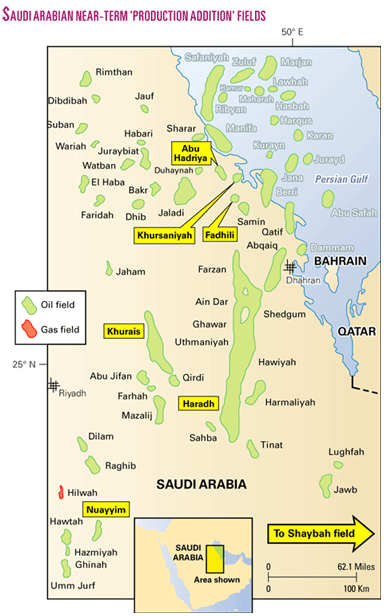
 I have seen the future of Saudi Arabian oil production, and it is Harmaliyah. No, really. Sure, there are a couple more good doses of oil to be had from Khurais and Manifa -- and perhaps a bit more from Shaybah -- but after that, what is there but a lot of little fields discovered years ago and produced for a short while before being mothballed? Saudi Aramco essentially admits this by including the rejuvenation of the Nuayyim field, up to a capacity of 100,000 barrels per day, in their list of megaprojects. Well then, why not Harmaliyah? It is of similar size, and both fields had about 50 wells drilled before being set on the back burner. Saudi Aramco hasn't said much about this little field in the shadow of Ghawar, so one might assume that nothing is happening there. Well, it just so happens...
Under Pressure
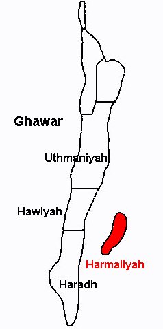
This little investigation has its genesis in a little-reported story from 2002. But first, let's back up a little. Harmaliyah, located 20 km east of the Hawiyah and Haradh areas of Ghawar, was discovered in 1971-1972 -- about the same time as Mazalij, a field of comparable size in the Khurais redevelopment. It was put into production and mothballed again three times over the years. There is a report of a gas-lift recovery effort in 1979-1980 similar to that employed in Khurais a few years later. In 1991, after the Gulf War, Harmaliyah was brought back online as part of the massive ramp-up of production which included the restart of Khurais and southern areas of Ghawar.
The most recent shutdown was in 1998, and over the few years that followed, engineers monitoring the pressure of the field noticed that it was going up. Some increase is expected in these circumstances, especially for fields produced under primary depletion, but in this case the pressure kept rising past where it should have stopped (perhaps the pre-production pressure). The engineers determined that water injection on the east flank of Ghawar was responsible for the pressure buildup. Because there was concern that the oil might get pushed around enough to make it less accessible, a decision was made to produce the oil to reduce the pressure. As the single GOSP (gas-oil separation plant) in Harmaliyah was no longer up to the task, the oil was allowed to flow by pipeline 57 km to Uthmaniyah GOSP #4. There was sufficient pressure to provide an initial production rate of 55,000 barrels per day. What has flowed since then is not clear, although the IEA reported 26,000 bpd for year 2004. This is just a splash in the scheme of things, but it seemed worth a little look.
Painting the Picture
The first step in an oilfield satellite investigation is finding the field on Google Earth; this can be done by obtaining an image with oil field locations, such as this one, and importing it into GE as an image overlay. After resizing the overlay to match with geographical features, a rough idea of the field boundaries can be had. The quality of many maps is less than ideal, however, so it doesn't pay to put too much faith into any one rendering -- even one from Saudi Aramco. Next, zoom in to an area of interest, hide the overlay, and start locating oil wells and other infrastructure. These locations can then be correlated with other more field specific maps which might exist, such as those with well spacings or reservoir delineations (all, if you are lucky).
 Shown at right are the oil wells identified from the current Google Earth view. The square placemark in the center denotes the location of the single GOSP. In the upper left of the image is the Hawiyah Gas Plant as well as the Hawiyah NGL Plant under construction (GoogleMaps). The northern part of the field is covered at low resolution only, so identifying wells is more difficult and often requires confirmation from well maps. The high-resolution coverage area for Harmaliyah dates to 2003, in contrast to 2006 for the Hawiyah infrastructure. An approximate field boundary can be visualized surrounding the wells, but fields not under peripheral waterflood will not necessarily have wells at the original oil-water contact (OOWC).
Flowing Out
 I was first interested in the destination of the "raw" oil exported from Harmaliyah, and this required some background work on Ghawar to identify the various GOSPs. The two southern-most of these units in Uthmaniyah are #4 and #13, and the more central of these is more likely the destination of the oil. Its distance from the Harmaliyah GOSP is also almost exactly 57 km. Piping oil to this GOSP does raise some questions, however, as there were four other candidates in Hawiyah (1,2,3) and Haradh (1) which are much closer. Perhaps they were operating at capacity (total liquid flow) at the time.
I also attempted to trace an oil pipeline connecting the Harmaliyah GOSP with UTMN #4, but this was unsuccessful. It is possible that, with two more GOSPs coming online in Haradh since 2002, the oil flow has been redirected. Alternately, the Harmaliyah unit might have been reworked (although no reports have surfaced) or the flow suspended. There is, however, a definite connection from Harmaliyah to the Uthmaniyah Gas Plant, as indicated by the red trace in the above image which runs right past the Hawiyah Gas Plant. Go figure. There appears to be more than one pipeline following that route and then connecting with major pipelines headed north, so it is possible that output from the Harmaliyah GOSP is flowing through it.
The Reservoir
Available information for Harmaliyah is rather sparse, but a rather useful source is
Geostatistical Modeling of Arab-D Reservoir, Harmaliyah Field, a Masters Thesis by
Ali Ahmed Mohammed Al-Salem from 1996. Included within are maps with well spacings and reservoir topography and information on the thickness and porosity distributions of the Arab-D reservoir. The well map aided in confirming locations of wells in the low-resolution areas. As is quite often the case, the distance scale on the map was in error by almost 20%.  A contour map of the Arab-D had no other referencing features. However, the top of the reservoir at many of the wells were determined using other data from within the thesis and these were then used to position and scale the contours on the satellite view as shown at right. The field boundary as drawn is also somewhat approximate. From the area enclosed (130 square miles) and an oil-bearing thickness of 100 feet with an average porosity of 14%, I estimate the oil originally in place (OOIP) at about 6 billion barrels. This might be a bit high, as the field is often reported as having reserves of 1.8 billion barrels, but that of course depends on what is assumed for the recovery rate. Harmaliyah has produced about 10% of its stated reserves.
This is all very interesting, yet Harmaliyah seems rather quiet in the 2003 view -- but that was then. The only hint that something is going on comes from a source (I'll keep it anonymous) that reports a rather thorough 3D seismic study of Harmaliyah was done sometime between 2000 and the present. Well, that and the satellite images presented next.
Harmaliyah 2006-2007
There are two DigitalGlobe preview images from 2007 and one from 2006 which can be used to identify recent activity in Harmaliyah, all taken in September of the year. These areas are shown in the outlines in the below left figure. Taken together, 12 new wells sites and 2 workover sites are identified across the field. These are represented in the below right figure with solid green placemarks (new) and green circles (rework). Click for a larger image.
 |  |
A close up for the area around the GOSP as revealed in the low-resolution images is shown below. Older wells are indicated by red placemarks. The left image (2006) shows one new well (green), and the right image (2007) shows four new wells (green) plus a rework of an older well (open green circle). New pipeline routes area also visible.
 |  |
The fresh sites visible in the 2006 images do not necessarily reflect work done in 2006, although previous work has shown that weathering of sites occurs rather rapidly. Shown below is one new well site further north in the field as it appears in the 2006 (left) and 2007 (right) images. At least in the low resolution images, the freshness wears off after a year or so.
 |  |
Conclusion
The recent addition of twelve new wells and a few workovers to Harmaliyah does not (apparently) warrant megaproject designation, but it does indicate considerable interest in a field that has received little publicity. Furthermore, it is likely that these wells are horizontal with perhaps multiple laterals, potentially yielding a considerable amount of oil overall. What remains unclear is whether the GOSP has been rehabilitated and whether the pressure supplied by the Ghawar injection wells provides enough support to lift much oil, although the addition of injectors for the Haradh II and Haradh III increments have possibly enhanced this capability. Finally, this latest drilling flurry in Harmaliyah might not be over yet.

Addendum: Water Injectors?
With further inspection, there are indications of new roads and/or pipelines following trajectories from the GOSP area out to the wells on the eastern side of the field --put in between the 2006-and 2007 image dates. It is possible that peripheral water injection will be used on this field after all.Previous entries in The Oil Drum, Satellite Edition:
Contact
- Content: editors at theoildrum dot com
- Tech support: support at theoildrum dot com
License

This work is licensed under a Creative Commons Attribution-Share Alike 3.0 United States License.
This is a very informative post. I would benefit from an executive summary paragraph at the beginning so I can get a handle on what it's all about before reading the details. Thanks.
Great detective work, Joules!
It does appear that KSA is starting to scrape the bottom of the barrel.
I, too, Greatly Admire your hours and hours of sleuthing--Big Kudos!
Joules, this is a fascinating use of publically available data and a bit of gumshoeing to provide a valuable insight into how Saudi Aramco appears to be managing its production commitments. Yesterday we saw the negation of the possible 2005-2006 oil peak in Rembrandt's post, but we didn't see the Aramco make much headway themselves to contribute to that new record.
So does this confirm what Aramco has said often: that there are many ecomnomically recoverable barrels still to go in Saudi Arabia and that this is a natural step to diversify their production base beyond the big five fields, or is this a sign more of the decline of those fields? I would be interested to see more of what the impression was of the recoverability and quality of the Harmaliyah field was when it was first discovered and why it was mothballed or left mostly undeveloped to begin with.
El Tel
Without knowing how this development ends up, I'm not sure what the implications, if any, are. The surprise is the number of new wells with basically no PR. Why no PR? Maybe they were going to surprise somebody on their birthday. Was the Nuayyim project harder to keep secret because it required bidding from contractors? And this is also a time when Khurais was getting started, Khursaniyah et. al. were struggling to get done, and rigs were in short supply.
There are most definitely recoverable barrels in SA, but it will take a lot of smaller fields like this to offset the decline of a big one. Redeveloping small, older fields could be characterized as diversification, but there is a fine line between that and scrounging. In any case, it doesn't matter. If they can't find some actual new fields after awhile, there will be nowhere left to drill.
As far as the quality of the reservoir, I haven't found anything about the permeability. I assume that lack of pressure support has something to do with it being occasionally mothballed, and maybe with the Haradh pressure support they saw encouraging things (warranting the seismic and then the wells) that they didn't know before.
Its interesting that your saying injected water in Ghawar is traveling this far ?
How big is the hydraulically connect region underlying Ghawar ?
I guess this would be the entire Arab D formation ?
As the Arab-D is sandwiched between two rather impermeable formations (Hith and Jubaila), it seems reasonable that static pressure would transmit rather far. But as to how much water flow could be expected, I have no idea. And I am skeptical that all those wells are going to be driven by injection-at-a-distance.
You motivated me to look one more time, and it does seem that they might be putting water injectors on the east side of the field (at least). See addendum at the end of the article.
great piece of detective work joulesburns.
"in this case the pressure kept rising past where it should have stopped (perhaps the pre-production pressure). The engineers determined that water injection on the east flank of Ghawar was responsible for the pressure buildup."
if this is true, it brings into question the management of ghawar water injection. i have been of the opinion that aaramco was on top of managing ghawar with extensive supercomputer modelling. but now this, wtf ? maybe they have adjusted their modelling to account for this out of body injection experience.
If you pump water into a hole in the ground, how do you make it only go west and not east? It will flow along the pressure gradient. So with Harmaliyah in at least minimal contact at the aquifer level, water will flow so as to equalize the pressure between the injector bottomhole and the Harmaliyah wells. Even with the wells flowing, they probably wouldn't notice the effect at the Ghawar injectors.
"they probably wouldn't notice the effect at the Ghawar injectors."
well, they probably didn't notice, but the model they ended up with (the history match)was not really representative of the actual reservoir. injection of xe9 barrels of water should have produced y pressure response in ghawar, if they had all the parameters correct. as i have pointed out on previous threads, a reservoir model doesnt give a unique solution. and that is why they need to be taken with a grain of sand.
Joules,
Why do you not state Lat and Long for these sites you show. How else can we look for them on Google, or am I missing something?
My apologies. I will provide more information in the future, including posting Google Earth KML files.
The Harmaliyah GOSP is at 24.447647 N , 49.468547 E or (Google Maps)
Superb detective work, and quite useful !
How many more of these "small" reservoirs are there in KSA ?
(1.8 billion URR is hardly small in most of the world).
However, I suffered a pang with this quote:
IEA reported 26,000 bpd for year 2004
The DC Metro extension to Tyson's Corner and Dulles would have saved 20 to 25,000 b/day if Bush had not killed it a month ago. Federal funding of $900 million denied. Construction would have started last week, helping stimulate the economy.
Harmaliyah is roughly equivalent to the Dulles Extension of DC Metro
Best Hopes for 1/21/2009,
Alan
They have 80 or so fields, but at least 25 of those are already in production or offshore. The biggest problem is remoteness and getting the infrastructure there. Harmaliyah was logical because Ghawar is so close and water for injection is available (if that is what they are doing there). The quality of the northern fields is also not well known. I would think they would group several such fields together into one project as they did with Khursaniyah et. al. to share facilities.
Most excellent detective work, greatly appreciated!
It's the bump in the foreground of the main picture. Looks like there's still significant oil. However, it looks like either the initial saturation was always low, or a lot of water has gotten in amongst the oil. (Note the orange color - compare to the deep red of most of South Ghawar. Harmaliyahs looks more like the basal areas of Haradh.
If that is a realistic representation, one wonders why they would bother -- or at least, why now?
Perhaps the problems caused by pressure from Ghawar are more serious since the other two Haradh increments have come online and they have to get the oil out now or lose it.
"the pressure kept rising past where it should have stopped (perhaps the pre-production pressure). The engineers determined that water injection on the east flank of Ghawar was responsible for the pressure buildup."
we are seriously in the dark here. imo, it is possible for injection into ghawar to create a pressure response 20km east, however to raise the pressure above original would require enough water injection to raise the pressure in the entire aquifer. there seems to be a missing piece or two.
All it would probably take would be a localized pressure difference between the aquifer on the west vs. the east side of Harmaliyah, and maybe that is what they were referring to. What the story said was:
This isn't much to go on. Looking at the existing wells (circa 2003), most of those connected are near the GOSP in the middle of the field (but I can't tell about those in the low resolution area).
I don't know what to make of the C/Hanifa thing, either. The thesis cited at top says: