| Energy Vision 2050 - part I | The Oil Drum | Hurricane Ike and Oil Refineries/Infrastructure Damage Models Thread #3 (21:00 EDT 9/11) |
Hurricane Ike and Oil Refineries/Infrastructure Thread #2 (9/10 16:30 EDT)
Posted by nate hagens on September 10, 2008 - 10:15am
(Welcome: we are now on a later and more updated thread, which can be found here: http://www.theoildrum.com/node/4525 NB: you may want to just go the front page (it will be post #1 or #2) to get to the most recent thread: http://theoildrum.com ...)
Hurricane Ike's current track predicts landfall between Corpus Christi and Galveston, but has been moving northwards. Within the current NHC storm path lies about 5 million bpd of US petroleum refining capacity. (Perspective: 5 MMBBL is about 30% of US capacity (about 15 MMBBL), and a bit less than 6% of global capacity (~85 MMBBL). Also, the MMS reported Wednesday that staff has been evacuated from 452 production platforms (63.0%) and 81 rigs (66.9%) – (95.9% of the oil production and 73.1% of the natural gas production has been shut-in as a precautionary measure for Hurricane Ike.)
(Welcome: we are now on a later and more updated thread, which can be found here: http://www.theoildrum.com/node/4525 NB: you may want to just go the front page (it will be post #1 or #2) to get to the most recent thread: http://theoildrum.com ...)

Current path estimates for Hurricane Ike (Methaz GFDK Sep 10 18Z (2pmEDT)-click twice to enlarge
For all graphics: Rigs/Platforms: Blue: evacuated only; Yellow will require inspection before restart; Red: damage requiring repair; Refineries: Black: operational impact (partial shutdown) Green: Operational impact (full shutdown) Red: Damage likely; Ports: standard hurricane flags for wind
Here is the latest update from Chuck Watson at KAC/UCF 10Sep 16:30 EDT.
Well, Ike didn't entrain any dry air, and has been moving quite slowly, although intensity has not picked up as much as I would have thought given that scenario. Still, I think the Cat 2 cap I was thinking this morning is probably low and the storm could reach Cat 3 before landfall. That said, I don't think it will be Cat 3 at landfall, but that is instinct more than analysis. GFDL sort of agrees - minimum Cat 3 at landfall. How's that for equivocating?
If the GFDL scenario plays out at Cat 3 or higher, current tracks are bad news for refining capacity. The current GFDL scenario is very close to the LBAR scenario mentioned this morning. Current track would take out long term 5-10% of GOM production, but that's not the problem. So, if the GFDL scenario plays out at a Cat 3 or higher, we are looking at having 20% of US refining capacity, and 5% of global capacity, offline for a month or more. Production side damage becomes irrelevant at that point.
Once again I'd like to remind everyone that these discussions are with regard to a bunch of valuable, important, but ultimately replaceable hardware. Follow the instructions of your local officials, and evacuate if that is recommended.
(Below is this mornings (sep10 11:30EDT) update, (since revised, but it contains additional information)
Ike's track continues to move slowly northwestward, and while organization is fair, it has apparently not started rapid intensification as of 9am. On the current track the storm will skirt south of the key Gulf of Mexico (GoM) infrastructure. However, it is vital to understand that very slight wobbles - even 10-20 miles - can make a huge difference in damage. Remember that swath of heavy damage for most hurricanes, even intense ones, is only 50-75 miles wide. Also recall that damage is exponential - 110 mph winds may be 10% higher than 100 mph winds, but will cause 20% more damage.
Above is the 8am ET LBAR scenario, which is about as "worst case" as this storm can get. It would take out over 5 MMBBL of refinery capacity for an extended period - 30% of total US refining capacity. This nightmare track is at the moment on the northern edge of the guidance, but well within the realm of possibility at this point. On the current official forecast track and key dynamic models (GFDL, HWRF) the storm grazes the southern edge of key production/processing areas, causing short term outages largely due to evacuations and precautionary shutdowns but no extensive damages.
As for intensity, there is dry air to the west of the storm. It is not yet entrained, but if it does, the intensity estimates may be on the high side. Our present thinking is that OCS and landfall intensity will not be over Cat 2, something the infrastructure can handle with minor damage. As a side note, these tracks are far enough north to avoid PEMEX assets.
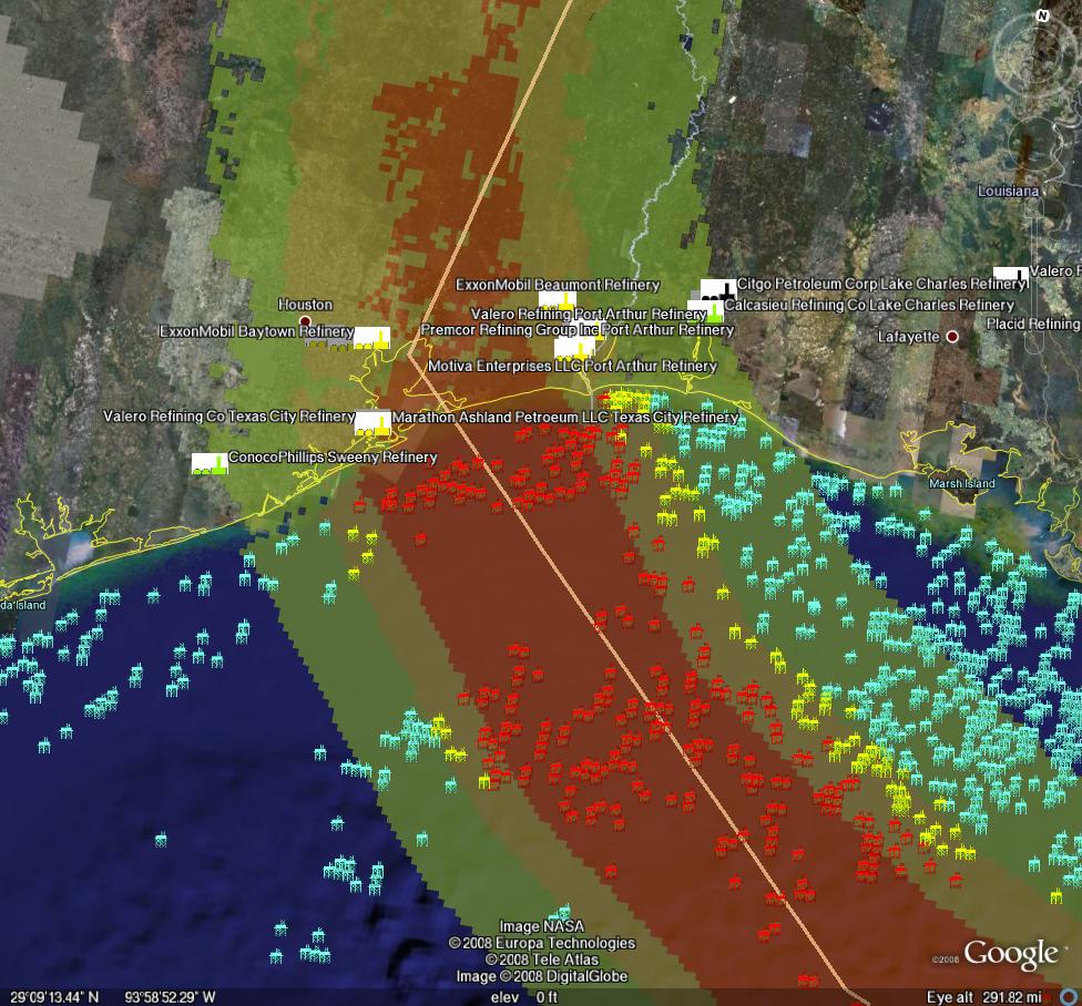
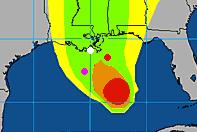
Current path estimates for Hurricane Ike (Methaz LBAR Sep 10 12Z (8am EDT))-click twice to enlarge
NHC Forecast for Hurricane Ike - click to go to Wunderground
Here are depictions of various Texas cities storm surge maps under different Hurricane scenarios from Weather Underground.
Regarding Port of Houston:
The Port of Houston is closing tonight as Hurricane Ike approaches, most coastal refineries will make storm decisions today, and offshore energy facilities are extending precautions they took just a week ago for Hurricane Gustav.
The Barbours Cut and Bayport terminals will shut down at noon today, and the port will close to all vessel traffic at midnight, spokeswoman Argentina James said.
The Port's 25-mile-long complex is a hub in the nation's energy network.
Forecasts Wednesday evening projected Ike would come ashore Saturday between Corpus Christi and Galveston.
Port Freeport, about 65 miles south of Houston in a mandatory evacuation zone for Brazoria County, shut down early Wednesday afternoon and expects to reopen Monday, Chief Executive Pete Reixach said.
As vessel traffic declined, gasoline retailers were gearing up for a possible surge of evacuating motorists.
Motiva, a refining and retail gasoline joint venture between Shell Oil Co. and Saudi Arabia's state-owned Aramco, said in a prepared statement that its coastal service stations and refueling terminals were being stocked up in anticipation of higher demand.
Shell-branded stations also were setting up generators to keep pumps running in the case of a power outage.
We will be posting periodic updates of track and damage forecasts here, because one never knows if one of these events will be seminal. We're not hurricane experts at theoildrum.com. Thankfully we have an expert meteorologist who sends us track and damage forecasts relevant to oil and gas infrastructure. What we try to do on this site, (and have been doing for over 3 years), is articulate the fragility and urgency of our nation's, and our world's, energy situation. As Hurricane Ike moves nearer, and professional analysts gauge the impact it may have on our energy infrastructure, feel free to browse our archives of empirically based analyses and perspectives on the many aspects of our energy situation that form the backdrop not only for this hurricane, but for any exogenous event that disrupts the increasingly uneasy balance between energy supply and demand.
Chuck Watson has put together a dynamically updating page that will reflect the latest damage models/forecasts at this link: KAC/UCF models. We will be updating this thread with damage estimate and breaking news as this story unfolds.
A note on our modeling process: we take the official NHC track, the raw computer model tracks like GFDL, HWRF, LBAR, etc, and even run our own in-house fast cycle track/intensity models. These track and intensity estimates are feed to our main hurricane model (TAOS), which computes the wind, waves, storm surge, currents, etc. at each point in our database of over 50,000 elements in the GoM like rigs, platforms, pipelines, pumping stations, refineries, etc. We then have engineering models for each type of infrastructure that calculates the damage and estimated down time for that element, as well as downstream impacts (eg if a pipeline is down, the upstream elements can't pump and the downstream elements don't get product).
PRODUCTION/INFRASTRUCTURE MAPS AND REFINERY INFORMATION
Here's a link to a really good map of oil refining/SPR storage facilities in respect to the path of Katrina (NB: OLD TRACK MAP!) and here is a listing of production and refining capability for the state of LA.
Just to give you a rough idea of where things are, the map above is a probability swath for Katrina (OLD TRACK MAP!) with the Thunder Horse platform as the red dot, and the other purple dot represents the Mad Dog development (100,000 bd); the Holstein development that produces at peak, around 100,000 bd of oil; and the Atlantis field that may have ramped up to around 200,000 bd in all. Put together these projects have the potential of around 650,000 bd, but as can be seen, they were sitting in an uncomfortable spot relative to the track of the Katrina.The white dot is where Port Fourchon is. This is where the Louisiana Offshore Oil Port, or LOOP, is located. Rigzone pointed out that this is where the foreign tankers offload, Google and Terraserve maps you can see that the area is very low-lying. One of the big concerns is that there will be sub-sea landslides or other ground movement that might affect the LOOP. Were this to be disrupted, then foreign tankers would need to be diverted elsewhere, with the likely port being Houston.
We have accumulated resources from previous hurricans below, but we'd like to find updated materials if you know of them. Recent refinery maps, recent rig maps in the gulf, recent gas fields, SPR facilities, the Intercoastal Canal, pipeline stations and transfer points, etc., etc. Leave links in the comments please.
Also, here's the EIA's Alabama, Louisiana, Mississippi, and Texas Resources pages. They will also likely come in handy. Also, here's a link to the national page.
Here's another good resource for infrastructure maps and such. (scroll down a bit)
Here's a map from CNN with large and small refineries laid out. (though it is an old storm track)
Very detailed piece by RIGZONE on rigs and other infrastructure in the area. (thanks mw)
Here's a flash graphic of the oil refineries and rig maps from Hurricane Rita, it emphasizes Beaumont and Galveston's importance. Click on oil production in the tab. Note the many rigs on the east side of the storm that will get the brunt of the damage from the NE quad of the storm...hence the high long-term GOMEX oil production damage estimates below.
Here's a link to Rigzone's coverage of Ike.
You want a detailed map? Well here's the probably the best MMS map I could find. Very detailed and lots of interesting stuff. (VERY big .pdf warning)
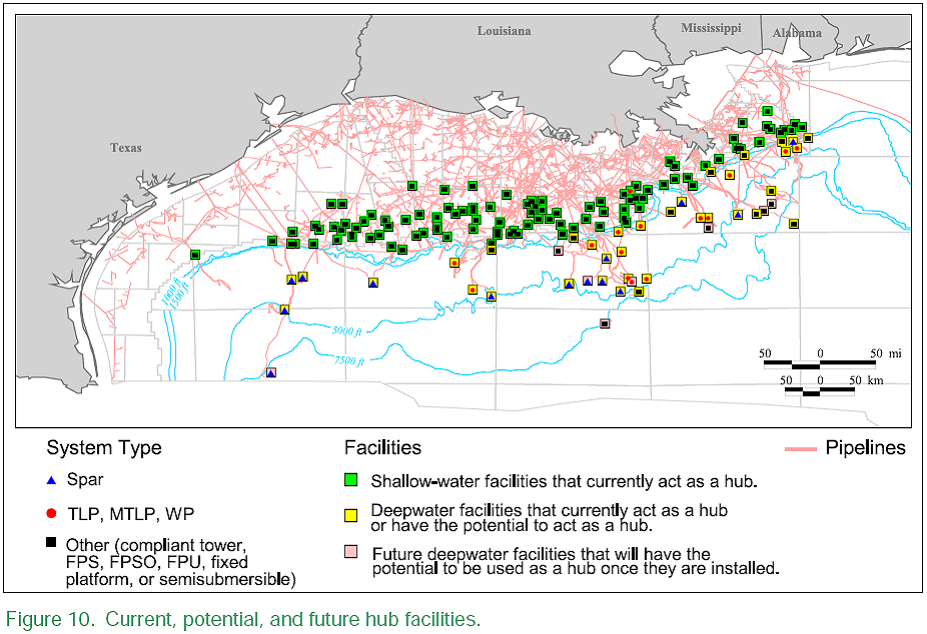
Also, Scott Wilmoth at Simmons & Co was kind enough to send us this map. The map below captures only deepwater infrastructure. For a complete list of deepwater development systems (includes operator, depth, location): http://www.gomr.mms.gov/homepg/offshore/deepwatr/dpstruct.html
(Please deposit new relevant links, graphs, and comments in this new thread...we have updated the resources part of this post with new maps and some more old maps and articles from Katrina on the LOOP and Port Fourchon--important parts of the infrastructure, as we learned about three years ago. Please leave personal anecdotes and themes unrelated to hurricane for the other upcoming 'bigger picture' posts, as some of these larger images are difficult to upload for those on dial-up)
We appreciate your help accumulating resources, stories, and newstips in the comment thread below!
Contact
- Content: editors at theoildrum dot com
- Tech support: support at theoildrum dot com
License

This work is licensed under a Creative Commons Attribution-Share Alike 3.0 United States License.
I'm getting calls from people wanting to flee the coast with their horses. Yet my weatherman tells me this storm could be quite powerful should the eye pass over us (Seguin, TX).
Move perpendicular to the path of the storm if you can.
If the track continues to move North and East we may be a good place to take refuge, but probably not if it goes overhead. Not near enough land between us and the coast to kill the winds.
Two things.
1) When's the latest Houston can be evac'ed.
2) When do they cancel the football games?
James
It's ironic, but under the current model, Louisiana would be the safe place to go if you live in Houston.
Yep.
From this shot:
http://www.ssd.noaa.gov/goes/east/gmex/jsl-l.jpg
I say it's Cat 2 now with a bullet.
I also say it's jogging to the N from it's WNW track. And that the NHC's
latest forecast having it stop cold just short of the coast and move to the N as a TS is way to conservative.
The Hogs football team leaves tomorrow PM for Austin.
And friends leave Friday. Someone's going to have to
either alter Ike or the fans soon.
If memory serves, Rita was initially projected to hit South Texas, and it ended up hitting the TX/LA border area.
A reminder of the damage caused by the 1900 Galveston hurricane, as it moved inland (note that it became a hurricane after it moved past Cuba):
http://www.islandnet.com/~see/weather/events/1900hurr.htm
Mc,
Just based upon the recent experience with Rita it takes at least 36 hours to move the majority out of Houston. But that schedule left many thousands stranded on the highway with empty gas tanks. The additional problem is that it's just not Houston that evacs. There will also be hundreds of thousand evacing from the coastal areas through Houston. Just a guess but I would say evac w/o the 18 to 24 hour trip to cover 200 miles would take 3 days. But I don't expect to see many folks pulling the trigger that early.
Hey Roc,
"Just a guess but I would say evac w/o the 18 to 24 hour trip to cover 200 miles would take 3 days. But I don't expect to see many folks pulling the trigger that early."
So folks should leave by this evening, but they're not going to. Is that right?
BTW-Do you know what the Matagorda nuclear plant
can take in terms of wind, storm surge?
Nuclear plants are designed to handle tornado type winds -235 mph plus. The Turkey Point plant was right in the eyewall of Hurricane Andrew, and I seem to recall that they measured 145mph before the anemometer failed. Most have containment berms and other protective measures that would keep storm surge from being much of a factor.
Take a look at:
http://www.nrc.gov/reading-rm/doc-collections/gen-comm/info-notices/1993...
and
http://www.nrc.gov/reading-rm/doc-collections/gen-comm/info-notices/1993...
Key lesson "learned" from Andrew is that while containment and safety systems do ok, all of the support equipment gets trashed so the plant is down for an extended period of time.
Texas officials spent all day Tuesday debating whether they should issue a mandatory evacuation (1,000,000 people) for the Rio Grande Valley, and instead pulled the FEMA people out and moved them to Austin "out of harms way."
Meanwhile, the forecast track has changed.
Since Rita, I've heard a lot of people say "We're staying right here" if it happens again. It was insane putting people out on a highway (and away from food and shelter) when they would have been better off at home. I think it's going to take a Katrina level problem, rescuing people from their rooftops, before an evacuation order is taken very seriously, given how poorly the forecasting has been.
On Sunday they were evacuating the Florida Keys. A couple days before that they were talking about Miami getting wiped off the planet. Yesterday it was Brownsville. I know I'm jaded, but it's just too fluid right now. By tonite they'll be saying Beaumont is in the crosshairs, probably.
The wed 8pm GFDL model now has Ike going directly over Houston. Oops.
The nuke plant is a good ways inland...about 30 to 40 miles at least. No storm surge problem there. Been a while since I drove by it but I remember lot of concrete so I'll guess wind won't be a problem for the plant proper. The transmission lines are a whole different game though.
After watching the latest N.O. evac seem somewhat unnecessary and remembering all the horror stories from the Rita evac I suspect many won't leave. But I just watched the latest loop of Ike. He's really assymetric...the east side is really strong and wet. Even if he hits 120 miles SW of us there could still be some serious problems here. Especially with electrical loss. Lots and lots of trees around Houston = thousand of downed lines.
Wrong, unfortunately.
The South Texas Project is about 10 miles as the crow flies from the bay, and about 14 from the Gulf proper.
http://maps.google.com/maps?f=q&hl=en&q=Palacios,+Matagorda,+Texas,+Unit...
The problem with Rita was that millions evacuated that didn't really need too (North and West Houston). Katrina was fresh on everyone's mind, and many (including myself) over reacted. That won't happen again. Anybody 30 miles inland is going to stay put. I have family coming in today from Freeport and Galveston today just in case. We've all learned a lot, and while it could get ugly, I'm more concerned about spending the rest of the week with my inlaws.
If you have the ones healthy enough to leave on foot do so by foot, then the evacuation could probably be done in a day or so. You cannot go 200 miles in a day by foot, but 30-60 miles (1 or 2 days' travel) should be enough to find safe shelter for everyone.
That would be like five people. We're talking South Texas, not exactly the fitness capital of the world :)
That said, the latest update of Jeff's Wunderblog should sober up anyone along the coast taking this too lightly.
So true. Statistically Texas is just about the most obese population on the Earth.
[QUOTE]Hurricane force winds will push inland up to 30 miles, along a 50-mile wide region where the eyewall makes landfall.[/QUOTE]
In other words, evacuating to a place just 30 miles inland means you'll almost certainly escape hurricane force winds and, with a little foresight, the storm surge. This makes me wonder why people generally evacuate much, much further before a hurricane, even if they do have a car or are able to get a bus?
PS: I've never been struck by a hurricane in my life, so I lack firsthand experience.
Actually, Texas is only the #15 most obsese state in the country. Source
Way to go, Colorado!
completely off topic, but I wonder if anyone has done a correlation between that map and the red states/blue states...at a glance there is a correlation. (but as I am told, there is a difference between correlation and causation...)
Looks to be a neutral correlation, as both the fattest and leanest are conservative states.
From Chuck's analysis:
"Also recall that damage is exponential - 110 mph winds may be 10% higher than 100 mph winds, but will cause 20% more damage"
I always heard that wind damage increases with the cube of the wind speed. Not exponentially.
thats with wind turbines - not sure you can make same assessment with 'damage', but I will point out your question to Chuck.
RSFB is correct. Power in the wind is always proportional to the cube of wind speed, not just for wind turbines.
Speaking from a physics standpoint, the force of the wind will increase as the square of the speed.
Speaking from a damage standpoint, this gets into engineering tolerances, workmanship, etc....I would imagine that the statistical distribution of an object's robustness (say, it's a house) wouldn't be linear - I think the amount of structures that would survive would rapidly fall, once you start having wind speeds that go higher than their design tolerances.
In short, the damage may well increase as the cube of the windspeed.
I guess it depends on what we mean with "wind damage". For a given structure, it seems the "cube" rule is generally accepted (a google search shows it). If we talk about total damage, it makes sense to say that the amount of damaged structures would increase near-exponentially since there are many more weak structures than strong ones.
The reason for the "cube" rule seems to be that the force increases quadratically with speed, while the amount of air exerting that force increases linearly with speed. x^2 * x = x^3.
When we're talking about oil rigs, at least the new ones should all be similar in terms of wind resistance, so the exponential rule doesn't seem very relevant in this context.
I know that the load carried by a river [eg sediment] is ppn to the cube of speed. Wind could be similair..
I was speaking in very simplistic and general terms. Force is, of course, square, and in very general terms damage is cubic. But in the real world you get weird vibrational effects and differential stresses (especially for industrial structures exposed to wind, wave, surge, and current velocities). I saw a discussion about companies that were adding additional anchors. I hope they did a stress analysis because in some cases, depending on where and how you attach the anchors, that could actually decrease the ability of the structure to handle the load and respond to extreme waves, and cause it to break up.
Pressure from the wind will scale as the velocity squared. Available energy, which might be relevant if the damage is caused not by pressure, but by a wind induced vibration, would go as the cube. IIRC, the energy in the sea state increases much faster than this, perhaps the 5th power, since bigger waves offer more purchase for the wind. But none of these are exponential, at least in the math sense, ( as an adjective it may be OK to use).
from chuck re report of ship measuring 20 foot waves 90 miles away from Ike:
"ship WPKD is showing 38 feet and 50 knot winds at about 90 miles, and they are in some very
squally weather. I don't trust most ship reports - they tend to be high.
Size matters, but peak winds/waves/surge matters a lot more. Remember, air gaps are about 35 feet for older near shore stuff, newer offshore gaps are at least 55 ft."
The latest from Jeff Masters:
It seems that a category 4 impact near Galveston is a real possibility. Any insights about what kind of damage this would inflict on our energy infrastructure?
here is a pdf showing the impacts of a Carla sized storm would have on modern day central texas (not saying Ike will be anything near that size/strength but 11am NHC forecast sounded rather bullish)
Dr. JeffMasters latest on hurricane Ike, 11:18 AM EDT on September 10, 2008
http://www.wunderground.com/blog/JeffMasters/comment.html?entrynum=1077&...
He discusses storm track, likely intensities and why the Texas coast is more vulnerable to storm surge than New Orleans was.
This is worth quoting in full I think. Also note latest GFDL run just put a Cat 4 on top of Houston so NHC may adjust track further north and east later.
HURRICANE IKE LOCAL STATEMENT
NATIONAL WEATHER SERVICE HOUSTON/GALVESTON TX
1238 PM CDT WED SEP 10 2008
I'd say this is out of date and about to change. Latest on 2pm EDT update has it moving NW now and I swear it looks like it's going to do a Katrina. I presume the models havn't been updated since it started tracking more North-Westerly rather than West North-westerly.
Marco.
This is what Jeff Lidner (government pro-met in Houston) has just said (quoted from storm2k again)
My coworker is thinking more of a Rita, but this time, that swings it right at Houston. He's boarding up his house in Alvin starting tomorrow. I'm going to pack up my electronics and head up to my parents house in Spring tomorrow after work. Here's hoping for the best!!
Latest guesstimate is Galveston.
To update the MMS numbers, 95.9% of oil production and 73% of natural gas production is shut in as of 11:30 today.
I have a horrible feeling about this
Thee Grim Reaper simply prefers a high-power buzzsaw vs the effort required in swinging a scythe. No doubting that Ike is very big and ugly: I bet the poor Cubans are beginning to think it will Never Stop Raining.
Cuba, Florida, Mexico this storm is HUGE!
This storm is going to affect real estate values because some estates wont be real anymore...
I hope that the refineries and infrastructure holds, but it only takes the weakest link before the entire chain is useless.
Here's the maximum storm tide in a worst case scenario for Texas coast
"Ike has a good chance of becoming the most destructive hurricane in Texas history--though not the most powerful."
http://www.wunderground.com/blog/JeffMasters/comment.html?entrynum=1078&...
and latest IR loop of Ike
http://www.goes.noaa.gov/HURRLOOPS/huirloop.html
As crazy as that looks, it really needs to have the description with it:
Figure 2. The maximum storm tide (storm surge plus an adjustment for hitting at high tide) expected from a mid-strength (145 mph) Category 4 hurricane hitting anywhere along the coast of Texas at high tide. This so-called "MOM" (Maximum Of the Maximum Envelope Of Waters) is computed using NOAA's SLOSH storm surge model. The plot above IS NOT the expected storm tide everywhere along the coast from a hit by Hurricane Ike. The plot is the MAXIMUM high water for a worst-case scenario Category 4 hurricane moving at the worst possible angle at the worst possible forward speed. As such, this plot is the combination of SLOSH runs from over 50 different simulated hurricanes approaching the coast at different angles and different forward speeds. The maximums plotted here are only possible along a 20-mile stretch of the coast on the north side of Ike's eyewall. SLOSH model runs are advertised as being in error by plus or minus 20%. Image credit: NOAA.
This is the worst case scenario of 50 simulated hurricanes, and would only happen w/in 20 miles of the eye (not 100 miles of coastline).
The UofT at Austin has an excellent collection of Texas Topographic Maps. Also some maps of evacuation routes and the like.
I started a current events thread over at peakoil.com as well: Hurricane Ike Impacts to Infrastructure. The Bryan Mound SPR site (226 mb) is only 15 ft above sea level, BP and Marathon's refineries at Texas City look to be even shallower - 8 ft? Topo map at UofT is dated 1932...these sites look likely to get a good soaking even if the eye is some distance off.
Unbelievable the NYMEX crude price is still going down, last time when it went down it went around the time of the last elections (2006). I see a correlation, does anyone, beside me, believes that the price its going down for election time and after will explode ?
--------------------------------------------------------------------------------
Washington Wants Oil Down, Stocks Up Before Election, Harrison Says
http://finance.yahoo.com/tech-ticker...JI,XLF,USO,XLE
link is broken (404 error)
Try this one
From the article
Thank you.
James
I believe the price is dropping because the so called rotten speculators got burned last month and don't know where to put their money. The oil coming from overseas cannot be refined until Port Fourchon is back up to full capacity. Leaving tankers to sit on the sidelines bobbing up and down in the GOM while IKE goes by.
CNN International Weather Forecaster is repeating the following mantra: "For all our international viewers don't worry this won't affect oil production, it's too far south."
Ha!
From the wunderblog's 4:00 CDT update:
Subject to change, YMMV, don't try this at home, trained forecaster on a closed course, etc. etc.
He's (CNN International duty weather guy) still repeating the story (as of posting time) but I get the impression from body language and comments he doesn't believe what he is saying....
He's showing maps of oil rigs, pipelines and refineries (in a weather forecast!) that look like they've been lifted from this thread but saying there is absolutely no problem.
Talk about lipstick on a pig as they say...
Meanwhile in the real world:
"Substance Abuse & Promiscuity
Sex, Scandal, Government and Oil Workers"
Reads the heading running on a story on CNN (Domestic and International right now) on "The Situation Room" from "the best team of reporters on television".
I think I'm going to have a drink.
Well, well. One hour later, a new forecaster (Bonnie Schneider) comes on and "this is going to be devastating for Texas, Cat 4." Showed consensus of computer models as trending towards Galveston and de-emphasised NHC centre position.
What a difference an hour makes.
Edit: Next forecast only shows the NHC cone. Strange weather forecasting (dis)continuity...
I do.
Definitely going sky high after the election.
There's a fairly major IEA report coming out in November too...
Definitely the most convincing comment on this thread.
http://www.financialsense.com/Market/daily/tuesday.htm
Here's an argument that the Saudis are manipulating the crude price (with supply) and the dollar exchange rate (with PetroDollars) to obtain a John McCain victory. I'm far from convinced. But judge for yourself.
Paul in Nevada
I'm not a big one for conspiracy theories - but this does seem a bit odd - and would support the House of Saud voting with their checkbooks and spigots..
"Hours after suffering a rare setback at OPEC headquarters, where the cartel said its members needed to lower production to keep prices from sinking below $100 a barrel, Saudi officials assured world markets on Wednesday that they would ignore the decision and continue to pump as much oil as needed. "
It seems to me the rational solution for the Saudis, they cannot risk, the republicans know the situation and their policy is known, so they don't want to hear the word change under any circumstances, the word change is the ultimate taboo for the Saudis, so we shall see if McCain Wins.
I'm from the other part of Atlantic but to me this sounded from the beginning like a text of a joke:
How can you make a republican to win!?!
You make him to run against a woman and a negro !
Yes I agree...a lot of monkey business is going on at the moment pre election..the greenback, massive shorting of precious metals by investment banks and obvious manipulation of the oil market.The fed looks like its doing everything to help the government get a return of the Republicans. Fundamentals everywhere are going out the window smelling of massive interference. IMHO
Hello TODers,
Yep, IMO, Ike slowly wobbling around in the GoM must be driving the govt. evac. planners absolutely nuts. Depending upon the actual evolution of the cane's steering forces: we may yet see a very surprising landfall location far right of the current NHC track. The NHC 5-day forecast with that sharp right turn gradually propagating back into the more immediate track might be very problematic...
Probably totally wrong as I am not an expert, but an interesting scenario to consider.
The problem with Ike is not so much Ike, but how incredibly predictable Gustav was. A single low rotating around a very strong ridge and not another low east of the west coast. That's why all 30 models were aligned.
Ike's meandering is the norm, but I suspect people want absolutes and can't understand why NOAA won't just tell them exactly where it's going to hit and when.
Ike was supposed to be moving at 12mph across the gulf. At 8 mph, that moves the landfall four miles further east every hour. If Ike were to slow to 5-6, it would direct hit Louisiana. If 3-4, New Orleans. If grasshoppers carried machines guns, birds wouldn't mess with them.
To your post specifically, I suspect people are doing the wait and see and the problem is they should be finishing up with preparations. If this were to stall for a day and then hit NOLA, I would bet everyone would be waiting at home when it hit. Or more accurately, wading at home.
I see the weather.com projected path was just updated. Mexico is no longer in the cone, Louisiana is.
People might want to top off their tanks even if they don't live on the coast. I recall North Dakota ran out first last time the double whammy hit.
Good luck, and don't be a hero. Get out, even if it is a pain in the ass.
What's funny is a few articles hit the net today saying gas prices are up due to Ike.
But they don't say anything about Gulf production being off-line (for the most part) since Labor Day due to Gustav!
This silence across the MMS is deafening. Even the weather.com doesn't seem interested. In fact, the NHC report referenced Ike's location as 720 miles East of Brownsville, as if Brownsville is somehow the target. Maybe it is, but I doubt it at this point.
I've never been more concerned, and I'm not talking about the Hurricane.
The US seems to be going "all in" right now.
I've been thinking the same thing all day. A big game of chicken.
I don't understand. What do you mean by "The US seems to be going "all in" right now.". Can you explain?
http://en.wikipedia.org/wiki/Betting_(poker)#.22All_in.22
It's a little more nuanced that this description.
See also:
http://en.wikipedia.org/wiki/Bluff_(poker)
What I mean is that it feels like they're betting it all on a highly risky wager that they can muscle through these storms and inventory declines while manipulating the markets to keep energy prices low for the elections.
They can manipulate the paper futures market, but not the spot market where physical oil is traded. I don't think there is any manipulation at all. The fall in price from $147 to $118 can be explained by China's reduction in imports. The fall from $118 to $102 can be explained by the rising US $.
I say Ike proves you wrong.
When there is zero predictive ability in a model, then the model is useless.
But it sure looks like the greenback is being manipulated.
I agree with this, suyog. But you can also manipulate the spot market by simply drawing down inventory (it's been clear for weeks that our gasoline supply was in trouble, heading into a hurricane season that was forecast to be more severe than usual). When you manipulate the oil price, you manipulate the dollar, and vice versa.
What I'm saying is that they've taken gasoline inventory too far down, and that this was a calculated all-in bet placed to increase their odds of winning the elections. It's a tactic that's been used before (the Goldman commodity index reweighting in 2006, Clinton's release of oil from the SPR in 2000).
The way the bet works is you get gasoline prices down even if it means drawing down inventory to a level that leaves the country vulnerable. Most of the time, you'll be able to get by--hurricanes, for example, won't be strong enough to create an emergency, or, if they are strong enough, they won't hit in the right spot.
So, most of the time you give yourself a real chance to win the election (when, if gasoline prices were higher, your chances of winning would be virtually nil). A small percentage of the time, your all-in bet goes sour and you seriously hurt the country.
It's bad governance, because it's too high risk. But a poker tournament player would make the bet in a heartbeat.
Maybe we're all also all in denial that our country is in trouble because that discredits our entire belief system about who deserves to rule and who is a better American than others.
A Confederate politician reacted to the controversy over whether slaves should be conscripted into the dying Confederate Army thusly: "If the Negro makes a good soldier, then our entire system is wrong."
Naive, wasn't he?
If the system crashes before November, we must either admit that it was horribly flawed, or we must just ignore it and muddle through with ever greater applications of military force and domestic repression and economic bailouts.
How else do we explain the utter disinterest in the Gustav damage, the multiplying bailouts, and the collapse of Pakistan?
Worse of all, when we invaded Iraq, hundreds of thousands took to the streets in protest. Now we are on an utterly unopposed march to restart the Cold War with Russia with absolutely no resources to do so. These are fast-moving events with consequences that could begin to pop up any day now. Zero interest.
And events now move rapidly.
Ike had better do something else, quick, because it's
own a worst case scenario track right now.
Downtown Houston gets 90 mile winds and 15 ft surge at the head of
it's estuary and the world is a brand new place.
In 4 more hrs it will probably be better to ride a bicycle out of Houston.
But looking at the 5:00 PM CDT "ensemble models" chart, they could also be right.
I say too soon to tell, but to err on the side of caution.
Hello Jteehan,
Thxs for responding w/good points. If one ponders this NHC graph:
http://www.nhc.noaa.gov/refresh/graphics_at4+shtml/211330.shtml?radii#co...
...you can see that Ike has been trending/curving more N than W in its track over the past 3 days or so due to the Coriolis Effect and built up inertial tracking forces. By mentally extending the historical track out-->points more to a Central GoM landfall.
IMO, it will take unbelievable amounts of energy to bend this inertial track plus overcome the Coriolis trendline; to induce a GIANT LEFT TURN to this huge 'cane to guarantee a central Texas landfall. I could be wrong...
I don't know either. The ridge is shaped like a Kidney Bean, and Ike, currently heading towards the concave part of the bean seems likely to bend back left. The models are usually pretty accurate looking one day out, so if they say left, it's probably left. The models have not been good this time at predicting speed, however, and there's the rub. It going to follow the bean's shape most like, but when?
Did you ever sign up for a blog?
jt
I've been saying exactly that.
If it's crossed Gustav's track, it's not by much.
Even now Ike is moving N and E of the NHC track. Ike
will have to make an extreme move in hours, to the West.
I don't think the Coriolis effect has much to do with the macro-level movement of whole hurricanes. Coriolis deflects fast moving winds. Hurricanes move at most 20 or so mph. They get deflected to the right (to the north and east) from the GOM due to the prevailing westerly winds across the US. These prevailing winds are somewhat influenced by how far south the jet stream dips, and that is why not all hurricanes take that right turn at the same time. Anyway, I'm not an expert, so I could be wrong!
Port of Houston to close Thursday as Ike approaches
http://www.chron.com/disp/story.mpl/headline/biz/5994288.html
Hurricane Ike Threatens Facilities in the Central GOM
http://www.rigzone.com/news/article.asp?a_id=66473
White House declares state of emergency for Texas ahead of Ike
http://platts.com/HOME/News/6949836.xml?sub=HOME&p=HOME/News&?undefined&...
Russia suggests dialog with OPEC, Oct meeting in Moscow
http://platts.com/HOME/News/6949835.xml?sub=HOME&p=HOME/News&?undefined&...
I'm not seeing the high pressure areas that were present on forecasts last week appearing in the next couple days. I don't see what's holding Ike south if that is the case. GFDL throws it right over Houston.
I also don't see anything in it's path to hold back intensification. It's not looking terribly impressive on IR, but the components are in place and by mornign we'll see a whole new storm. Unlike Gustav, this thing is lining up to have a very solid core element like Katrina had.
I'd say that this is going to be as real as it has gotten for a long time in TX, in terms of Gulf tropical systems.
The boys from www.UKweatherworld.co.uk are headed to Houston/Sugarland tomorrow. They are very rarely wrong and usually ahead of the curve by 2 days.
The latest photo has Ike moving to the NE of it's official NHC track:
http://www.ssd.noaa.gov/goes/flt/t4/wv-l.jpg
"We have a huge oil and gas industry presence here with refineries and oil and gas processing facilities," said city spokeswoman Kim Womack. "We don't want to issue a mandatory evacuation because that would completely shut down operations and make recovery very difficult."
http://afp.google.com/article/ALeqM5gB7cTyHWWZQjYI33S9rVPWH0d8Yg
The Port of Houston is beginning to clear out in anticipation of Hurricane Ike and will close to all vessel traffic at midnight Thursday, port spokeswoman Argentina James said today.
The Barbours Cut and Bayport terminals will shut down earlier, at noon Thursday.
The Port finalized its decision this afternoon based on the advice of the U.S. Coast Guard, port spokeswoman Lisa Ashley-Whitlock said.
The Port's 25-mile-long complex is a hub in the nation's energy network, with massive oil imports reaching the U.S. through its waters. The Port of Houston ranks first in the U.S. for foreign waterborne tonnage and second in total tonnage.
http://www.chron.com/disp/story.mpl/headline/biz/5994288.html
We have some posters in Japan, if I'm not mistaken. This little storm might be worth paying attention to for them.
A tropical storm in Okinawa is pretty much a non-event.
Are you in Japan? If so, do you mean for oil or for residents? In Korea, it would be the same. People here treat a typhoon (hurricane) like a thunder storm, yet, every time one comes along lives are lost, homes are destroyed, businesses wiped out... It's surreal. The one advantage Korea has is that virtually all the buildings are cement forms, so it's flooding that gets them, not the wind, and even that has much more to do with rainfall. Even that is strange considering Korea has a monsoon season. You'd think they'd have figured out how to manage the rainfall...
Anyway, not about oil, just a heads up for anyone who is local there. the media here is really poor about reporting typhoons until they're on top of you.
Cheers
Yeah, I'm in Tokyo.
Okinawa is a frequent target of typhoons. A tropical storm isn't much of a worry for them.
The media here is pretty good about reporting typhoons as well. Hurricanes are as big a part of the culture as earthquakes.
Yea, I lived in Guam, and unless it is blowing 200 plus, a non event.
As I recall, Pamela blew out the indicators at 240----
Often, there are no small boats left after a storm.
My brother has been though so many of theses, it makes the GOM look look a lake.
He has lost several boats, but that is the conditions one put's up with.
One thing we've learned from Gustav: hurricanes that damage oil infrastructure bring down the price of oil. They are never as bad as anticipated and we can all relax--the price of oil should plummet soon after Ike hits.
Global warming! Bah. Nothing to see here, move inland.
What TV station here in the US uses the tagline "We Know Drama?"
They gots nuthin' on Jeff Master's blog right now:
He goes on to say Ike is likely to be a extremely dangerous major hurricane at landfall, and will likely do $10-$30 billion in damage. and
So far, there are few mandatory evacuations, but several voluntary ones and some schedule adjustments (TCU is playing their game at noon in fort worth instead of 6:00 PM, etc.) Here's a list from the Houston Chronicle, not sure if they'll keep it updated or post a new one as conditions change. As I write this, Galveston has issued mandatory evacuations for west island only (beyond the seawall. Note there are only two bridges off galveston, one headed straight for where Ike is supposed to be and the other over the intercoastal. Last time I was there that one was still being widened.
The Port of Houston will close Thursday. Everything is starting to shut down overnight Wednesday, lots of talk with various oil cos. Various news reports (like this) are trying to make it clear that there is NO evacuation in Harris County, just coastal areas / barrier islands are affected right now. Of course, that could change tomorrow.
Again by watching www.globalboiling.com http://www.globalboiling.com
it is easy to see that now the waters of the Gulf are WARMER than they were during the Katrina summer (unlike last week with Gustav when they seemed approx. the same.)
Now they are predicting a 4 at landfall. If you just watch the water temps you could have guessed that earlier in the week.
I still believe the water temps are the best way to estimate the strength of a storm that is well organized.
Good morning stormchasers.
IKE is remaining remarkable resilient (low cat 2 as of 4am EDT) to wind speed increases despite a pressure of 948mb which is consistent with a cat 3-4 hurricane.
Jeff predicted cat 3-4 by morning. unpredictable beasts these! It does appear to be a monster though.
http://www.nhc.noaa.gov/graphics_at4.shtml?5day?large#contents
http://www.ssd.noaa.gov/goes/flt/t4/vis-l.jpg
Instead of higher winds, it seems to have gotten bigger. It's freaking huge.
Ike appears to have gotten so powerful that it seems like the very long, incoming spiral bands are now sucking in Pacific Ocean clouds across the narrow parts of Central America.
It's the second "storm of a century" in as many weeks!
Now that Earth's shadow had passed, here is the Beast:
http://www.ssd.noaa.gov/goes/flt/t4/vis-l.jpg
I don't know if the eyewall is not present, cycling through a new eyewall replacement or just too tiny compared to the whole size of this thing that you can't see it!
Might it get sucked down like an ice skater, and speed up? Is such an analogy physically possible?
Marco.
Projected surge levels are scary. Northen Texas and LA coastlines are in for a good soaking.
Here's the latest from Jeffrey Lindner (Harris County Flood Control District Meteorologist)
http://soprano.boost-technologies.com/windProducts/details/4981
http://soprano.boost-technologies.com/windProducts/bigPlot/4981
http://earth.esa.int/ew/cyclones/Hurricane_Ike-sep08/
Hello TODers and ATTN: Methaz,
http://uk.reuters.com/article/oilRpt/idUKSP3428820080911
---------------------------------
Flint Hills Resources (FHR) said on Thursday it would shut the West and East Plant operating units at its 288,000 barrels per day (bpd) Corpus Christi, Texas, refinery during Sept. 11-15 in preparation for Hurricane Ike.
--------------------------------
Bang! There goes some more gasoline and diesel supply even before Ike comes ashore. Hope the GoM locals have filled their jerry cans
In looking at this weeks TWIP, Gasoline lost 6.5 Million Barrels in stocks to settle at 187.9 on hand. I think we fully expected this due to the shut in near New Orleans from Gustav. Now I haven't kept up to date on the restart progress there, but we are about to lose a significant amount of production, for at best a week, and we are approaching what many believe is our Minimum Operating Level for Gasoline. And if the production near Houston is in fact severely damaged, as we are seeing the potential of, how long before we are below MOL (1 week?), and what happens then.
I guess we'll find out what the MOL is for sure.
One thing for sure, we will absolutely confirm price manipulation if there are shortages with falling prices while after Katrina, there were no reports of widespread shortages, but prices shot up for months.
Hurricane Damaged Oil Facilities + Presidential Election = Oil Company conundrum
Latest update on Ike by JeffMasters, 11:32 AM EDT on September 11, 2008
Category 2 Ike is larger and more powerful than Katrina
http://www.wunderground.com/blog/JeffMasters/comment.html?entrynum=1080&...
Ike is now larger than Katrina was, both in its radius of tropical storm force winds--275 miles--and in it radius of hurricane force winds--115 miles. For comparison, Katrina's tropical storm and hurricane force winds extended out 230 and 105 miles, respectively. Ike's huge wind field has put an extraordinarily large volume of ocean water in motion. When this swirling column of water hits the shallow waters of the Continental Shelf, it will be be forced up into a large storm surge which will probably rival the massive storm surge of Hurricane Carla of 1961. Carla was a Category 4 hurricane with 145 mph winds at landfall, and drove a 10 foot or higher storm surge to a 180-mile stretch of Texas coast. A maximum storm surge of 22 feet was recorded at Port Lavaca, Texas. Despite the fact that the center of Carla hit over 120 miles southwest of Houston, the hurricane drove a 15-foot storm surge into the bays along the south side of the city. I don't expect Ike will reach Category 4 strength, thus its maximum surge is not likely to reach the extreme values above 20 feet seen in Hurricane Carla. Like Carla, though, Ike will probably inundate a 180-mile stretch of Texas coast from Port O'Connor to just north of Galveston with a 10-15 foot storm surge. This will occur even if Ike is a Category 1 storm at landfall. The latest experimental storm surge forecast From NOAA's SLOSH model (Figure 1) shows a 10% chance that Ike's storm surge will exceed 15-21 feet at Galveston. The Galveston sea wall is 17 feet high, so it may get overtopped.