| Hurricane Ike and Oil Refineries/Infrastructure Thread #2 (9/10 16:30 EDT) | The Oil Drum | DrumBeat: September 11, 2008 |
Hurricane Ike and Oil Refineries/Infrastructure Damage Models Thread #3 (21:00 EDT 9/11)
Posted by Prof. Goose on September 11, 2008 - 10:10am
(Welcome: we are now on a later and more updated thread, which can be found here: http://www.theoildrum.com/node/4525 NB: you may want to just go the front page (it will be post #1 or #2) to get to the most recent thread: http://theoildrum.com ...)
Hurricane Ike's current track predicts landfall within 100 miles of Galveston Saturday morning; but the storm isn't strengthening much yet and the track has been moving northwards--so, because of the wobbles in the track, models are still uncertain. Within the current NHC storm path lies over 5 million bpd of US petroleum refining capacity. (Perspective: 5 MMBBL is about 30% of US capacity (about 15 MMBBL), and a bit less than 6% of global capacity (~85 MMBBL). Also, the MMS reported Wednesday that staff has been evacuated from 452 production platforms (63.0%) and 81 rigs (66.9%) – (95.9% of the oil production and 73.1% of the natural gas production has been shut-in as a precautionary measure for Hurricane Ike.)
(Welcome: we are now on a later and more updated thread, which can be found here: http://www.theoildrum.com/node/4525 NB: you may want to just go the front page (it will be post #1 or #2) to get to the most recent thread: http://theoildrum.com ...)
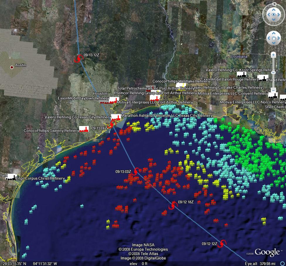
Current path estimates for Hurricane Ike (Methaz GFDL Sep 11 (15:00 EDT)-click twice to enlarge
For all graphics: Rigs/Platforms: Blue: evacuated only; Yellow will require inspection before restart; Red: damage requiring repair; Refineries: Black: operational impact (partial shutdown) Green: Operational impact (full shutdown) Red: Damage likely; Ports: standard hurricane flags for wind
Here is the latest update from Chuck Watson at KAC/UCF as of 11 Sep 21:00 EDT:
Still waiting on strengthening. Official NHC intensity forecast at a Cat 2. Hoping that this doesn't blow up overnight. We'll know a lot more in the morning. Relatively same forecast as earlier.
11 SEP 15:00:
The latest track models are converging on the Houston area, between Freeport and High Island. That's bad news from a refinery perspective. The question is increasingly shifting from "where" to "how strong", and with Ike that's a tough question to answer. The threshold to watch for as the storm approaches landfall is 100 knots (115mph). For every 5 knots less than that the damage drops off rapidly, and more importantly the recovery times improve. If the storm landfall intensity is over 100 knots, we start to see damage that requires major structural work and therefore recovery times start to skyrocket.
The latest GFDL scenario is not pretty, and the refinery estimate from this morning (nearly 6 MMBBL/day of refinery capacity for over a month, (38% US/5% global capacity) is in play.
I'm still skeptical the surface winds will be over 100kts at landfall. The good news is that Ike is having a hard time getting organized. There is a fair amount of dry are to the west, and if it gets entrained the storm will collapse. The bad news is that Ike is still pushing the dry air out of the way, and there is still plenty of time for it to get organized. Lots of discussion about the size of the wind field, and it is true that will elevate water levels and damage coastal property. But from the oil/gas perspective, that doesn't concern me as much as the organization of the winds in the core and damage swath. HWRF essentially crashes the intensity to tropical storm strength before landfall - I think that's pretty dramatic, but a cat1 landfall wouldn't surprise me. A Cat 3 would. Again, don't bet your life on it - get out of the way!
I'd leave the door open to a further east track as well - like Port Arthur - that's a 1 in 3 in my thinking. (2 in 3 Houston, 1 in three to the east).
We will be posting periodic updates of track and damage forecasts here, because one never knows if one of these events will be seminal. We're not hurricane experts at theoildrum.com. Thankfully we have an expert meteorologist who sends us track and damage forecasts relevant to oil and gas infrastructure. What we try to do on this site, (and have been doing for over 3 years), is articulate the fragility and urgency of our nation's, and our world's, energy situation. As Hurricane Ike moves nearer, and professional analysts gauge the impact it may have on our energy infrastructure, feel free to browse our archives of empirically based analyses and perspectives on the many aspects of our energy situation that form the backdrop not only for this hurricane, but for any exogenous event that disrupts the increasingly uneasy balance between energy supply and demand.
NHC Forecast for Hurricane Ike - click to go to Wunderground
Here are depictions of various Texas cities storm surge maps under different Hurricane scenarios from Weather Underground.
Regarding Port of Houston:
The Port of Houston is closing tonight as Hurricane Ike approaches, most coastal refineries will make storm decisions today, and offshore energy facilities are extending precautions they took just a week ago for Hurricane Gustav.
The Barbours Cut and Bayport terminals will shut down at noon today, and the port will close to all vessel traffic at midnight, spokeswoman Argentina James said. The Port's 25-mile-long complex is a hub in the nation's energy network. Forecasts Wednesday evening projected Ike would come ashore Saturday between Corpus Christi and Galveston. Port Freeport, about 65 miles south of Houston in a mandatory evacuation zone for Brazoria County, shut down early Wednesday afternoon and expects to reopen Monday, Chief Executive Pete Reixach said. As vessel traffic declined, gasoline retailers were gearing up for a possible surge of evacuating motorists. Motiva, a refining and retail gasoline joint venture between Shell Oil Co. and Saudi Arabia's state-owned Aramco, said in a prepared statement that its coastal service stations and refueling terminals were being stocked up in anticipation of higher demand. Shell-branded stations also were setting up generators to keep pumps running in the case of a power outage.
Here is the latest update from Chuck Watson at KAC/UCF as of 11 Sep 9:30 EDT:
Ike continues to wobble towards Texas - where is still an open question - and continues to not intensify. As noted by NHC this morning, the interior structure of Ike is unusual. It's not unusual for a storm to have two eyewalls during what is called an eye replacement cycle; it is unusual to maintain these structures over an extended period of time. The outer wind maximum is helping to keep Ike weak; if it collapses the inner core can strengthen rapidly. I'm still thinking mid Cat 3 is the max this storm will get, and high Cat 2 at landfall, but those who argue for Cat 4 could still be right if Ike gets his act together - I just don't think that is likely. As usual, take all such speculation with a grain of salt and if you are in the way of the storm get out.
(9/10 16:30 EDT Update):
If the GFDL scenario plays out at Cat 3 or higher, current tracks are bad news for refining capacity. The current GFDL scenario is very close to the LBAR scenario mentioned this morning. Current track would take out long term 5-10% of GOM production, but that's not the problem. So, if the GFDL scenario plays out at a Cat 3 or higher, we are looking at having 20% of US refining capacity, and 5% of global capacity, offline for a month or more. Production side damage becomes irrelevant at that point.
Once again I'd like to remind everyone that these discussions are with regard to a bunch of valuable, important, but ultimately replaceable hardware. Follow the instructions of your local officials, and evacuate if that is recommended.
(Sep 10 11:30EDT) update, (since revised, but it contains additional information)
It is vital to understand that very slight wobbles - even 10-20 miles - can make a huge difference in damage. Remember that swath of heavy damage for most hurricanes, even intense ones, is only 50-75 miles wide. Also recall that damage is exponential - 110 mph winds may be 10% higher than 100 mph winds, but will cause 20% more damage.
Chuck Watson has put together a dynamically updating page that will reflect the latest damage models/forecasts at this link: KAC/UCF models. We will be updating this thread with damage estimate and breaking news as this story unfolds.
A note on our modeling process: we take the official NHC track, the raw computer model tracks like GFDL, HWRF, LBAR, etc, and even run our own in-house fast cycle track/intensity models. These track and intensity estimates are feed to our main hurricane model (TAOS), which computes the wind, waves, storm surge, currents, etc. at each point in our database of over 50,000 elements in the GoM like rigs, platforms, pipelines, pumping stations, refineries, etc. We then have engineering models for each type of infrastructure that calculates the damage and estimated down time for that element, as well as downstream impacts (eg if a pipeline is down, the upstream elements can't pump and the downstream elements don't get product).
PRODUCTION/INFRASTRUCTURE MAPS AND REFINERY INFORMATION
Here's a link to a really good map of oil refining/SPR storage facilities in respect to the path of Katrina (NB: OLD TRACK MAP!) and here is a listing of production and refining capability for the state of LA.
Just to give you a rough idea of where things are, the map above is a probability swath for Katrina (OLD TRACK MAP!) with the Thunder Horse platform as the red dot, and the other purple dot represents the Mad Dog development (100,000 bd); the Holstein development that produces at peak, around 100,000 bd of oil; and the Atlantis field that may have ramped up to around 200,000 bd in all. Put together these projects have the potential of around 650,000 bd, but as can be seen, they were sitting in an uncomfortable spot relative to the track of the Katrina.The white dot is where Port Fourchon is. This is where the Louisiana Offshore Oil Port, or LOOP, is located. Rigzone pointed out that this is where the foreign tankers offload, Google and Terraserve maps you can see that the area is very low-lying. One of the big concerns is that there will be sub-sea landslides or other ground movement that might affect the LOOP. Were this to be disrupted, then foreign tankers would need to be diverted elsewhere, with the likely port being Houston.
We have accumulated resources from previous hurricans below, but we'd like to find updated materials if you know of them. Recent refinery maps, recent rig maps in the gulf, recent gas fields, SPR facilities, the Intercoastal Canal, pipeline stations and transfer points, etc., etc. Leave links in the comments please.
Also, here's the EIA's Alabama, Louisiana, Mississippi, and Texas Resources pages. They will also likely come in handy. Also, here's a link to the national page.
Here's another good resource for infrastructure maps and such. (scroll down a bit)
Here's a map from CNN with large and small refineries laid out. (though it is an old storm track)
Very detailed piece by RIGZONE on rigs and other infrastructure in the area. (thanks mw)
Here's a flash graphic of the oil refineries and rig maps from Hurricane Rita, it emphasizes Beaumont and Galveston's importance. Click on oil production in the tab. Note the many rigs on the east side of the storm that will get the brunt of the damage from the NE quad of the storm...hence the high long-term GOMEX oil production damage estimates below.
Here's a link to Rigzone's coverage of Ike.
You want a detailed map? Well here's the probably the best MMS map I could find. Very detailed and lots of interesting stuff. (VERY big .pdf warning)
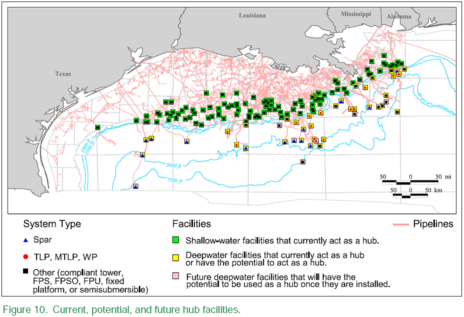
Also, Scott Wilmoth at Simmons & Co was kind enough to send us this map. The map below captures only deepwater infrastructure. For a complete list of deepwater development systems (includes operator, depth, location): http://www.gomr.mms.gov/homepg/offshore/deepwatr/dpstruct.html
(Please deposit new relevant links, graphs, and comments in this new thread...we have updated the resources part of this post with new maps and some more old maps and articles from Katrina on the LOOP and Port Fourchon--important parts of the infrastructure, as we learned about three years ago. Please leave personal anecdotes and themes unrelated to hurricane for the other upcoming 'bigger picture' posts, as some of these larger images are difficult to upload for those on dial-up)
We appreciate your help accumulating resources, stories, and newstips in the comment thread below!
Hurricane Ike and Oil Refineries/Infrastructure Damage Models Thread #3 (21:00 EDT 9/11)
PDF version
206 comments
Hurricane Ike and Oil Refineries/Infrastructure Damage Models Thread #3 (21:00 EDT 9/11)
PDF version
206 comments
Contact
- Content: editors at theoildrum dot com
- Tech support: support at theoildrum dot com
License

This work is licensed under a Creative Commons Attribution-Share Alike 3.0 United States License.
Here are some resources from the previous thread. (Please bring over others that I missed.)
Here's the maximum storm tide in a worst case scenario for Texas coast
"Ike has a good chance of becoming the most destructive hurricane in Texas history--though not the most powerful."
http://www.wunderground.com/blog/JeffMasters/comment.html?entrynum=1078&...
and latest IR loop of Ike
http://www.goes.noaa.gov/HURRLOOPS/huirloop.html
As crazy as that looks, it really needs to have the description with it:
Figure 2. The maximum storm tide (storm surge plus an adjustment for hitting at high tide) expected from a mid-strength (145 mph) Category 4 hurricane hitting anywhere along the coast of Texas at high tide. This so-called "MOM" (Maximum Of the Maximum Envelope Of Waters) is computed using NOAA's SLOSH storm surge model. The plot above IS NOT the expected storm tide everywhere along the coast from a hit by Hurricane Ike. The plot is the MAXIMUM high water for a worst-case scenario Category 4 hurricane moving at the worst possible angle at the worst possible forward speed. As such, this plot is the combination of SLOSH runs from over 50 different simulated hurricanes approaching the coast at different angles and different forward speeds. The maximums plotted here are only possible along a 20-mile stretch of the coast on the north side of Ike's eyewall. SLOSH model runs are advertised as being in error by plus or minus 20%. Image credit: NOAA.
This is the worst case scenario of 50 simulated hurricanes, and would only happen w/in 20 miles of the eye (not 100 miles of coastline).
The UofT at Austin has an excellent collection of Texas Topographic Maps. Also some maps of evacuation routes and the like.
The Dude started a current events thread over at peakoil.com as well: Hurricane Ike Impacts to Infrastructure. The Bryan Mound SPR site (226 mb) is only 15 ft above sea level, BP and Marathon's refineries at Texas City look to be even shallower - 8 ft? Topo map at UofT is dated 1932...these sites look likely to get a good soaking even if the eye is some distance off.
"I started a current events thread over at peakoil.com as well: Hurricane Ike Impacts to Infrastructure."
I? You mean "we." You know, the Royal We. The editorial, man!
Heh, searching for that on Google Images one of the first hits was from TOD. You, I mean we, have fingers in manys the pie!
Cut and Paste my friend. :) Changed it to give you credit. My bad.
The CAT2 value seems extremely misleading given the size of IKE. The wind field is huge, already rivaling Katrina, and the speed is slow.
I still don't understand what's keeping oil prices down, but gasoline is another story and it's screaming higher up 16.5 cents at this post. It makes for a nice crack spread.
Lastly, I'm still amazed that the MMS is not covering this. I guess it can't compete with Roger Clemens ditching his own dinner party, presumably to board up the windows of his Texas mansion.
If you remove a large amount of refining capacity (6 million bpd) and only a few hundred thousand bpd of crude production, that equals a big glut of crude on the market for the duration. I've been one of those who says that oil can't fall below $100, but a glut of that magnitude could certainly do it. A great chance for nations to fill their strategic reserves.
Has it not become blatantly obvious that it is the US gummint that is behind this price drop? We now have proof of how the US manipulated the dollar rise as well as the crash of gold and silver. They have done the same for oil.
The dollar has risen dramatically against the horrible fundamentals of this currency, just as gold and silver have fallen 45% against rampant inflation. Now we have oil plummeting against improving fundamentals. This will continue until election day. And then . . . .Oh Boy!
It's time to wake up and see financial fascism for what it is. There are no more free markets, only manipulated markets. But not to worry, this whole hollowed out economy will soon come crashing down. As Rick Santelli put this AM, "This economy is a room full of mousetraps into which a couple golf balls have been tossed. Do you really think the Fed can catch them all?"
Well, not really blatantly obvious. If they had so much power to do this, it never would have hit $150 in the first place.
Lehman is a big energy trader, and they're exploding as we speak. That would be my first guess. People getting in front of the demise. Other energy hedge funds are rumoured to be blowing up as well, creating additional downward pressure.
And, it always goes down in September.
If you believe the government can make it go down, then you must be able to equally believe speculators can make it go up.
I'm in now way saying you are wrong. Just that my opinion, while shifting slightly towards yours, is still different.
Thanks for the reply.
I totally concur with this. Governments have intervened in currency markets for decades. This I know for a fact because at Salomon (and Lehman ) we had a 'batline' directly to the Fed on the currency desk.
But oil is a different story. First of all, americans don't buy oil. They buy gasoline, which is rocketing today. This oil sell-off of past month is 70%+ about deleveraging and firms HAVING to get out of postions (be they energy or frozen shrimp futures), 25% about expected much slower economy and 5% supporting dollar and that whole 'election' line of thinking.
But that might change soon if Ike continues on this track...even 'money' can't produce gasoline. Especially money....
We could argue around the edges of your handicapping, but my numbers would be pretty close to yours.
The one thing I'd point out is that the timing and extent of the deleveraging is heavily influenced by recent gov't actions. So I'd boost the intervention weighting because of that.
Okay, so what will your argument be when the price goes below the marginal barrel? In my less than humble opinion it is the Feds who started this short squeeze in oil and are maintaining the downward pressure. A little bit of leverage in derivatives goes a hell of a long way. Moreover, we have no idea what agreements were made with other NOCs. There's a strong rumor going around that the Saudis are playing ball because they're terrified of Obama getting elected.
When the price suddenly snaps back we will have our answer but most people will either cry manipulators or supply/demand. Problem is, gov't data is no longer credible. All trust is being lost in these massive interventions. As Paul Volker stated on 9/5, "the markets are broken."
The price of both oil and natural gas ARE below the marginal barrel. For natural gas, there is so much fixed cost associated with drilling the well, that to shut-in production as a 'timing' event costs more than just taking a small loss. Though at these prices it will reduce drilling. Same holds for oil especially for offshore where fixed costs are high - onshore there does exist some ability to shut in production. OPEC is acting according to Hotelling Theory.
Does not compute. The last $20-$30 rise in crude was due to the momo players piling on without understanding what they were doing. The combination of credit crisis, deleveraging and oil retracement has exacerbated move in oil. IF the feds were playing the game of 'keeping things intact until election', why wouldnt they sell gasoline and diesel futures, which is what 'voters' care about? The open interest in crude oil futures (as of 3 days ago) has been declining, NOT rising - if fundamentals pointed to higher prices and speculators and investors were BUYING crude and government was 'selling' to keep price down, you would see an explosion of open interest. You do not.
I like Volker and happen to agree. But they take a long time to officially break. I wonder if he understands the second law...
Probably because they know they'd break the backs of too many US refiners. By hitting oil they hit a world and not local market.
You miss my point that they don't have to use oil to manipulate the price. As with currency, you use the producers of currency. Without the cooperation of major central banks, the Feds can't manipulate the dollar. In this case it was mainly Bank of China. The significance of the Saudis and OPEC is that they don't sell their oil in US market, so getting them to drop price/increase supply a bit doesn't hurt them as much. Then it produces a knock-on effect in western markets. Plus, you are well aware of the recent massive disinformation campaign the Saudis/OPEC have engaged in. Ask yourself what was the reason for that.
I thought the marginal barrel was closer to $80 than more than $100, assuming you don't mean the crazy marginal bbl.
Much of the reduction in oil price is due to the lowering of risk premium.
Finally the administration is doing the right thing, preventing Israel from launching an attack on Iran.
This also explains some of the strengthening of the dollar.
http://www.haaretz.com/hasen/spages/1019989.html
I hope this is not disinformation - standard practise when you are preparing for a strike is to play the possibility down.
If it were an American strike the Israeli's would not need bunker busters.
There was a report (cannot locate the URL) that the Georgian's were hosting Israeli reconnaissance drones. These were purported to be very advanced with a low radar signature and were being used to identify / monitor events in Iran. The conflict in Georgia ended this activity.
I'm quite relieved that Putin has laid down some clear markers to caution the Bush presidency.
Sending bombers to Venezuela shows that military adventurism won't be tolerated there either.
Jeez, I sound like a commie lefty!
I was always about as right wing as they get, but we clearly have a Mafia let loose now, and they will stop at nothing.
It would be interesting to know how many others have given up the habits of a lifetime as they recognise the scams going on.
In some ways this is like the fall of communism, when the idea became clearly bankrupt, as much of the patterns of capitalism have been fatally corrupted, and it would be dishonest of me not to recognise the severity of the flaws which are wrecking destruction.
Still, I suppose astute commentators as diverse as Adams and Jefferson recognised these dangers centuries ago.
Actually the report mentioned that the two air bases the Russians destroyed were intended to launch the attack.
This is the Debka link, but it was widely published outside the US
http://www.debka.com/headline.php?hid=5559
Well one report (picked up by others but which a lot of people disagreed with) suggested the bases would be used to launch the attack). The reports about drones - for whatever purpose, were more widespread.
I have to agree with that. Plus if the Executive Branch were doing this, presumably they would be taking Oil up and not down. One of McCain's winning points with Joe Sixpack is Domestic drilling - in order to continue cheaply fuelling the pick-up truck & SUV. Climbing Crude would reinforce the urgency of drilling and drilling quickly.
Unless the Admin is doing this to help Obama ;-)
IMO it is pretty blatant. The premium to insure USA guv debt just rose to an all time record the other day-you wouldn't expect any currency to strengthen as the country's debt is considered riskier. I guess unless we see widespread shortages of product with declining prices not everyone will be convinced (maybe not even then, if gold and silver is any example).
I guess after Fannie Mae/Freddie Mac there is nothing the business class will not allow the government to distort to protect their larger interest in control.
Back in the days of the civil rights protests, blacks organized boycotts of mass transit lines to protest segregated seating. Though they were key customers of these companies and the boycotts hurt, they did not succeed. Presumably the businessmen who owned the transit lines were willing to bleed in the short run rather than face the prospect of operating in a South without a caste system.
Now just to show the South in a more positive light while reinforcing the social power of American business, contrast this with what happened in Houston. When the business elite learned that a campaign of civil disobediance was being organized to break segregation at the lunch counters in the downtown department stores, it moved to disarm the conflict. Oveta Culp Hobby, who served in Eisenhower's cabinet, owned the Houston Post, and represented an ostensibly progressive image that Houston aggressively cultivated, spearheaded an effort to keep news of the protests out of all Houston media. Meanwhile the businessmen negotiated with each other to terminate Jim Crow. Their fear was not the protestors, but the possible actions of white racists - the Frankenstein monster they had created and exploited for generations. Houston went from Jim Crow to integration in a smoke-filled room. It could hardly have presented itself as Space City, home of the future, otherwise.
Short-term control versus long-term survival. That is the choice facing our owners, and the decision could still go either way.
Fascinating! Never knew that about Houston - can you recommend a good source that goes into greater detail?
Houston's choice on Jim Crow may indicate that when the problems of peak oil and environmental catastrophe hits that those industries and cities most tied to high-tech global capitalism will be most willing to see government step in to solve problems in a big way. So, we would expect that purely old-line industrial and nationally-based industries and corporations will be most opposed to government intervention.
A quick google found this. You might contact the author and ask for her sources.
The currency is strengthening because the amount in circulation is down. There is a big shortage of cash out there. And since the government+Fed is refusing to print, treasury borrowing is crowding out everyone else.
It is ironic, but if at this point only the Sovereign wealth funds have money and lots of it. They can buy anything they choose - and are choosing to buy nothing but treasuries.
If the Fed is to avoid Great Depression II they must lower rates now and by a good margin. IMO further significant lowering of rates is unlikely - because someone wants to take the dollar up (I can speculate on the reasons - but shall refrain from doing so)
The irony is that the one thing the US can do is create money and is choosing to destroy it. The US economy is basically a service economy (to quote Leanan - doing each others laundry) and the economy needs money to function, because people like to get paid in cash for their services.
Are we going to a barter system as the depression hits :-)
I agree with Research 24, 'financial fascism' is a good term for the level of manipulation going on here. I don't think the US market, vis-a-vis the world market, is an explanation for a 30% drop in crude futures at this historical juncture. Nor should one of the most troubled currencies in the world be on the rise given the massive national debt, both old and newly acquired this week. Hedge funds dumps (with their backs to the wall) makes some sense. But I would also note we've seen this pattern before the election. It is ironic that a recent article discussed the inability to monitor speculation--right, but they aren't thinking about the trillions of black fund dollars that I am...
Cat 2 seems conservative to me. Take a look at Ike now (midnight Thurs), and I think you'll see a Cat 3 at least in the making.
Alan reported in yesterday's DrumBeat that there's a mandatory evacuation of Port Fourchon for Hurricane Ike due to surge.
The Houston Chronicle hurricane blog last night said the current track is "just about the worst possible place a storm could make landfall" (for Houston).
Port Fourchon
Mandatory evacuation of Port Fourchon was last night. This morning La 1 is reported as impassible and likely to remain so for 3 days due to rising waters.
My guess is an additional 3.5 day delay in getting Port Fourchon back into full operation. Electrical repair crews north of Golden Meadow will continue till winds rise. No one south.
Additional storm surge damage (Gustav was 7 feet) could undo repairs and cause greater damage.
Alan
http://icons-pe.wunderground.com/data/images/at200809_surge.gif
Much of the hurricane coverage on TOD is dedicated to monitoring the impacts of hurricanes on existing energy infrastructure. For a moment, let me suggest an alternate mindset: how about viewing hurricanes as a marvelously effective natural heat engine for converting low-grade energy (warm surface waters) into relatively concentrated form (high winds and big waves)?
Wikipedia estimates the ROM heat of energy release of hurricanes at 50-200 terawatts; by comparison, the total human world-wide energy consumption is around 15 TW:
http://en.wikipedia.org/wiki/Orders_of_magnitude_(power)
Harnessing the power of a hurricane for human use (i.e., electrical generation) is certainly a daunting proposition, but given the enormous energy which is represented there, it seems worthy of a little discussion. Has anybody ever given this a serious look before?
I've been thinking about doing a post along those lines, as hurricanes are most interesting from an energy point of view.
But what you are saying is not true. To be sure, hurricanes are heat engines. However, heat engines take concentrated heat energy and disperse it, taking advantage of the temperature difference between two reservoirs. In the case of hurricanes, concentrated heat energy in the upper ocean is transferred high into the atmosphere and dispersed radially. Only a small fraction of the total energy transferred from the ocean goes into wind (and then wave) energy, and a lot of this is dissipated back into heat in the near vicinity. In fact, a lot of the energy is lost into space via infrared radiation.
For a brief discussion on hurricane energy, read this document by Kerry Emanuel of MIT, one of the world's foremost experts on hurricanes:
ftp://texmex.mit.edu/pub/emanuel/PAPERS/hurrpower.pdf
For even more reading, check out his bibliography:
http://wind.mit.edu/~emanuel/cvweb/cvweb.html
Almost all of the papers in the above are freely available online. This should keep you engaged well into the 2009 hurricane season.
As for the possibility of extracting energy from hurricanes for human use, see this:
http://www.hurricaneenergy.org/IndexContent.htm
I don't think this is at all feasible, but it is food for thought.
JB
Daunting to say the least. I suspect that somewhere some government research group has looked every conceivable energy source. As an example, my wife was telling me about a project in Japan trying to gain energy from lightning strikes.
The problem with all of these things is that the energy source is sporadic mandating an enormous capacity for energy storage.
Yes, as JoulesBurn pointed out, the hurricane is a means of dissipating the huge heat energy stored. So you'd essentially be trying to siphon off parts of the energy as it is being transferred in the hurricane. There is so much energy being moved at that time that one should in theory be able to capture quite a bit, but doing so and storing it would be.....difficult.
A much better strategy would be to make use of the same initial energy source that it powering the hurricane to begin with. We could make a giant peltier device and float it in the GOM.
Great video coverage of Ike from VOA
"Flying Through The Eye of the Storm"
http://www.youtube.com/watch?v=4gfcxPmlnNk
"Hurricane Hunter aircraft are flying into the storm gathering data for forecasters at the National Hurricane Center in Florida. The modified cargo planes are operated jointly by the U.S. Air Force Reserve and the National Oceanographic and Atmospheric Administration. VOA's Paul Sisco has more on a recent flight through a storm."
NYMEX to open trade early on Sunday due to Ike
Of course this is electronic trading only. Floor trading hours will not be affected.
Does anyone understand why they are doing this early electronic trading on Sunday? I don't quite know the logic behind it.
It's probably good business. Emotions running high.
Let me just say that I am thankful to not be in the investment and trading industry because the constant changing of rules here and there would drive me absolutely batty.
How do you know what to expect from day to day?
Good point. You don't know.
Here's a link to data from a buoy in the middle of the gulf.
Ike is forecasted to make a close approach to this buoy at some point in the next day or so...
http://www.ndbc.noaa.gov/station_page.php?station=42001
I love those buoys. They provide so much more context to the overall weather situation, and are priceless for us fisherfolk. Gusts over 50 knots and wave heights close to 30 feet as of 3pm CDT!
We hope you'll spread this another work of The Oil Drum around to your friends, the web, and to other discussion boards. Metafilter, Digg, name it.
Also, we're on twitter: http://twitter.com/theoildrum
MSNBC is reporting that Galveston has been ordered to evacuate, and Ike could hit as a Cat. 4.
The WU blogs were pushing for this for more than 24 hours. When it comes to evacs, I think you have to go with "could" levels rather than "probably will" surges. Once water is 2' over the seawall, there won't be much livable in the Galveston.
Does anybody know how much grid repair capacity the country maintains? I worry than after Fay, Gustav, and Hanna there simply won't be enough to go around.
With Gustav, 1M+ were affected, but most evac'd. With Ike, 4M will be affected, and few will have evac'd. What is this going to do in terms of infrastructure repair stress?
I wonder what happens if the local power company's make the call to their sister companies, and they say, "sorry, we're tapped out"? Given that it took a month to fix poles and transformers from our ice storm last Dec, where maybe 1M were affected, these outages seem catastrophic to me.
I also wonder about our abilities to keep reentering disaster zones to put things back in place for the next disaster. Reminds me of the pin setting machines at bowling alleys. It's perverse that the labor and materials costs of doing this is a "plus" for our national GDP. Sort of like our Iraqi adventure- what else could these resources have been directed to and with what long term implications?
Also, looking at aerial images of refining infrastructure one is struck by the settling ponds and what looks like slag heaps all near the shore. I recall post-Katrina video of the gooey residue left in neighborhoods near refineries and the challenges of cleaning and disposing of oil-soaked sediment. Texas City refineries make New Orleans plants look like chemistry sets. This is going to be a real mess.
Entergy reports less than 100,000 folks still w/o power from Gustav (almost 900,000 restored since the storm passed).
Hey, if you're power is out and the water is all muddied up, the best thing to do is to add a drop of chlorine to your drinking water. I've worked with the American Chemistry Council on their 100 Years of Safe Drinking Water campaign. I'm pretty sure you can get chlorine at your local Walmart, and just a drop per gallon will do.
I'm in Baytown TX just across from the largest US refinery. They've ordered mandatory evac from the low areas of town. The refinery is on the ship channel as are most. Given our location on the east side of landfall they're anticipating a significant storm surge. All refineries in the area began shutin last night. Still a crap shoot but I'm guessing it may turn a little more north by tomorrow and hit Houston dead on. Everyone is leaving the coastal areas but no word of any great masses leaving Houston yet.
I think the precise impact will depend on steering that depends to a degree on intensity, and that intensity is very hard to estimate. If the eyewall gets its act together winds will spin up to match pressure, and we'll see at least a strong Cat 3.
A Cat 3 with a major surge heading into Houston would be quite devastating I fear, especially since people there seem to only now be waking up to the possibility.
People may gripe a lot about Big Oil, but they are much more cautious with these storms than politicians are!
Yep, the way the storm track landfall point is gradually migrating further north [or right] each 24 hours is IMO very worrisome for pointing right up the gut of the Houston Ship Channel. Also, in my NON-EXPERT read of the latest NHC Forecast Discussion [11 am time]: it seems the Pro-Mets are even getting slightly confused as to the intensity, spin performance, eyewall development, and other details on Ike. My feeble two cents. I have no idea if that portends good news or bad.
rant on/ I sure am glad FEMA listened to my much earlier advice to rehabilitate some of the rundown parts of Cleveland and/or Detroit so that in the off chance of a true worst-case scenario national emergency in the GoM area, people would have some half decent shelter. /rant off
http://www.chron.com/disp/story.mpl/headline/biz/5995474.html
As other posters have pointed out, manipulation in this area is impossible, unlikely or just the realm of tin hat nuts. Wholesale gasoline at $5 with the futures price at 2.77-sounds reasonable.
Though Chuck can chime in on the impact on refineries, I think Ike is going to be more a storm about surge than winds. It now has a triple wind maximum which is taking energy away from being a concentrated major. However the absolute huge size of the storm is creating incredible waves in the GOM. Note the above picture of Gustav on Sep 1 vs this mornings situation with Ike below:
A Cat 2 will do plenty of damage with that wall of water....How tall are those berms around Galvston/Houston refineries?
Also, it's gonna hit at high tide at current pace...
Bottom line - storm track is going to dictate whether we have shortage of refined products, not intensity, in my opinion.
What's the source of those wave fields? Looks like a very coarse linear wave model - I'm really not believing that waves inside the eye will be less than 11 feet with 60ft+ in the eyewall!
That said, we are seeing 30ft+ wave in the vicinity of Ike, and in the interior 50ft+ are likely. But those waves won't get inshore. The water depth when the wave breaks is 1.28 times the wave height (for oceanographers out there, yes, I'm generalizing for the unwashed masses so don't get snippy). So if you 20 foot storm surge at the coastline, the peak wave will be about 0.78*20 or about 15.5 feet crest to trough, or about 8 feet above water level (28 ft crest elevation). That's on a smooth surface - roughness causes breaking sooner, so waves right at the coastline cause a lot of damage, but not so much inland. Velocity (current flow) is another issue, and interestingly the water running off after the storm can cause a lot of erosion damage.
(image at 11:45EDT of wave heights (from Chuck Watson of Methaz - Note - i trust these numbers more than the above graph which was pulled from a weather site....i.e. unknown source)
Those 30 footers are getting close to Louisiana offshore platforms...
Rigzone lists everything in Ike's path: Direct Hit: Hurricane Ike Zeros in on Facilities and Rigs. Preparing for Ike to Strike has maps as well. Looks like Chinook FPSO should be getting battered around now. The Discoverer Deep Seas drillship is square in Ike's path, unfortunately. It was suggested to me that drillships would be steamed out of the way of a big storm's path, but this wasn't done with Gustav, and I'm assuming isn't standard practice, or practical. Would like to hear more about this.
Dude,
The currently drilling Deep sea wells began delatching (unhooking from the sea floor) starting Tuesday. Drillships might try to steam off location though I don't know of it happening in the past. The big semisubmersible rigs don't have that type of mobility. They'll stay on location. Since Rita/Katrina most semis are set inplace with twice as many anchors as before. The real risk with theose is if they break free from the anchorage...they don't take heavy sea well unless moored or under tow.
Except that the track is toward the Texas coastal plain, in which the primary roughness elements are strip malls and overpasses.
Hurricane Ike's wind, gust and central pressure history, as of the 1500Z 11 Sep 2008 NHC advisory:
As mentioned in the NHC discussion, the drop in central pressure to pre-Cuba-landfall levels, without a corresponding sharp rise in wind speed is rather interesting. Maximum winds of 85 kt is rather low for 945 mb. But Ike's high-wind field is very large, with hurricane force winds reach as far as 100 nm from the center, and tropical-storm force winds 240 nm. This is similar to Katrina, which landed near Buras, LA, with a 920 mb central pressure, which typically would have corresponded to much higher winds than the Cat-3 speeds witnessed (110 kt), and Katrina had a very large wind field. Ike also shows an unusual structure, with essentially two eyewalls, or what's being called a double wind maximum, and the presence of an outer eyewall probably has prevented a more rapid strengthening of wind in the storm's core. The outer wind band appears to be contracting at this time. The inner eye has a diameter around 10 nm.
Here's the history of Ike's forward movement speed:
Looks like the hurricane has picked up speed a little, after quite the slow-down over the past day or so.
And here is Ike's track compared to Gustav:
Hurricane Ike continues on a more southern route than Gustav.
[Minor edits.]
-best,
Wolf
Hello Greywulffe,
Thxs for the info. So does Ike have to be like an figure skater?-->pulling the arms in tight to drastically speed up the spin rate [a tight single eyewall]? Or because it is so damn big, it can function just fine with mostly two eyewalls most of the time? Thxs for any reply.
That's one way of looking at it. A hurricane with a very tight pressure gradient in the vicinity of the core is likely to have much faster winds, but with a narrower reach (generally speaking, when the pressure gradient is doubled, the average wind speed also doubles). Ike currently has a central pressure similar to what Charlie (2004) had at landfall (941 mb for Charlie). In the case of Charlie, the region of very low pressure was much smaller; therefore surface pressure gradients were much higher (meaning higher winds, but in a smaller region). Here's a rough diagram to illustrate the difference:
-best,
Wolf
thxs for reply with cool graphics [bonus!]
Something of a novice, so someone please comment on my conclusion.
I have family in Katy and looking at http://www.stormpulse.com/ and using the advance arrow in the tracking box at the bottom left of the map, I see 115mph winds at 6AM Sat with storm centered at 29.5N, 95.9W.
Using that long/lat at Mapquest, this puts the center about 16 miles SSSW of Katy at that time.
So depending on post-6AM direction, it looks to me like Katy is going to be almost directly hit, or at best, be within 15-20 miles of a direct hit.
15 miles from a center of 115mph winds means what?? 80 to 100mph?
Wind at a local level, such as for a town like Katy, is notoriously hard to forecast accurately due to a high sensitivity to terrain, transient storm features, and many other variables. Katy is about 50 miles inland. Frictional dissipation due to terrain interaction can significantly lower the potential wind speeds. If Ike lands with say 115 mph maximum winds, then 80-100 is perhaps a decent guess. Could be lower (probably not higher). Depends not only on track (which determines one's proximity to the storm's center), but also speed. After moving over on a significant landmass, hurricanes tend to weaken asymptotically to a similar state (tropical depression) within about 24 hours. For example, for a location 50 miles inland, a forward speed of 10 mph verses say 20 mph, could make a significant difference on the actual wind speeds experienced (5 hours of degradation verses 2.5 hours).
In any event, low Cat-1 hurricane force winds of 75 mph (with higher gusts) are rarely experienced inland, and if the forecast is showing the possibility of such, then take it seriously. Such wind speeds are very destructive and most certainly life-threatening. Many trees would topple, windows will break, portions of roofs will be yanked off of houses and other structures, small debris will fly through the air, among many other forms of damage.
-best,
[minor edits]
Wolf
Thanks Wolf, good info.
Perhaps I'm misreading Stormpulse, but it seems to be saying those 115mph winds will be 16m SSSW of Katy, not at landfall. In other words, after it is about 35 miles inland.
Hope I am misinterpreting.
Right now, I would treat that as a rough approximation (45-hr forecast). If that track verifies, then, yeah, Katy will almost certainly get a serious blow.
-best,
Wolf
Eric Berger at the Houston Chronicle has repeatedly said in his chats yesterday and today that Katy is not in play for serious issues.
http://blogs.chron.com/sciguy/archives/2008/09/live_chat_on_ik_3.html
From Jeff Masters:
(bold mine)
http://www.wunderground.com/blog/JeffMaste...p;tstamp=200809
So the storm with the highest IKE (Integrated Kinetic Energy) rating in 40 years is Hurricane Ike? Don't know what to say...
I knew Ike was big but this is still surprising given the lower wind speed.
KE contained in the uplifted water is ~2 orders of magnitude higher than that in the wind for a cyclone, IIRC. so size matters.
What to say? yIKEs!
The view from New Orleans is that Ike will be a massive storm surge event over 100s of miles of coast (BAD for Galveston Bay) but an "average" wind event, not as bad as hurricane from 1980s. Peak surge may not be worst case due to Cat 2 winds, but a LOT of water is sloshing around.
However, reserves of supplies for restoring electrical service have just been depleted in Louisiana. Crews are exhausted as well.
Alan
Will a metropolis sit dark tomorrow, in a 100 mile sea of darkness, without repair materials to turn the lights back on?
On TWC they were chirping about a week without power for some. I imagine a month will be optimistic for many. Perhaps far longer if equipment cannot be had.
Stockpiles of many electrical items were depleted in the last week after Gustav. And the crews are exhausted.
Alan
I guess a rough analogy might be standing in a spa with two different types of motion. Consider the wave motions resulting from rotating a finger at high speed, versus moving at a lower rotational velocity in a circle with your arm at water level at right angles to your body.
http://www.bloomberg.com/apps/news?pid=newsarchive&sid=aXyQzM3snx7o
"And the role of Tina Turner will be played by: Texas coastline" - ala Fark.
About to be hit in her refining capacity.
Ouch.
Just talked to my mother-in law, who is just west of downtown Houston, inside the loop. She reports several gas stations are already out of gas. She has loaded up on non-perishable food and on water, and her car is full of gas. She plans to ride out the storm, and if it looks like they will have no electricity for a while, she will drive north to Dallas at that point. She said the main roads are presently pretty much gridlocked in the Houston area.
Someone posted on Dr. Master's blog a bit ago that gas stations were running out of gas on the west side of Houston - and traffic is just starting to ramp up.
WT,
Heading to Dallas might not be the best route IMO. For some reason that's the way most in Houston run. But doing so keeps you in the path. They did that for Rita and many either ran out of gas first or took 20+ hours to make it. But if Ike keeps running north Dallas could be a mess too. Most likely problem there: no electricity and too many evacuees. For Rita I left about 10 hours before landfall: No traffic on the roads by then but still blue skies. Not sure if so many folks are leaving so early this time. I'm in Baytown across the road from the Exxon refinery. If we decide to boogie we'll head west. The storm is very lopsided now. The west side (San Antonio side) will be much less effected.
Good luck to your kin.
I did tell her to make sure that we had electricity before she started north. I assume you read Nate's post about Integrated Kinetic Energy.
A lot of meteorologists are predicting this will be another Carla, which caused damage as far inland as Dallas.
The Astros want to try to get their baseball games in this weekend, but Cubs don't want to go down there and get stuck in a hurricane.
Can't say as I blame them...
Will we have enough gas?
CenterPoint, Entergy girding for storm damage
Marathon Begins Shutting Down Its Oil Refinery in Texas City
Hurricane Ike forces Valero to evacuate refineries, gas stations
Total Evacuates Gulf of Mexico Platforms Before Hurricane Ike
BP shuts Texas City, Tex refinery ahead of Ike
ConocoPhillips Shutting Houston Offices Before Hurricane Ike
Exxon shutting Baytown, Texas, refinery
Houston traffic cameras
I clicked on a few and they look fine, but I'm not as familiar with Houston geography.
Edit: I clicked on 610/West Loop and it's pretty solid. No worse than I've seen during rush hour, but it's noon on a Thursday :)
From the link, the mandatory evacuation areas are Areas "A" and "B" (areas shaded yellow & green).
http://traffic.houstontranstar.org/weather/hurricane_evac.html
FWIW, at 8:30 Thursday night, roads are moving pretty close to posted speeds. But, they've added a "C" to the evac maps.
**Note to general public - we don't have a Strategic Petroleum Reserve for gasoline, heating oil or diesel...
Oh, yes we do. For heating oil, anyway:
http://www.eia.doe.gov/oil_gas/petroleum/special/nehor/nehor.html
So if the strategic heating oil reserve (which seems to be only for the northeast, and centered around NYC) can contain up to 2 million barrels and that would last 10 days and that estimate was from way back in 2000, I would assume we'd need a lot more these days. No?
Also, they don't give the units it's being counted in, but it looks to me like the most recent accounting (29 August 2008) has the total amount at 2,000 barrels, not 2 million.
Good thing it's not heating season yet. Does anyone know if this reserve is actually refilled on a regular basis? I mean, is it just cause it's not heating season that the reserve levels are so low?
I like how the logic behind having a 10-day reserve is so that, in case of disruptions of heating oil delivery due to bad weather, ships from the Gulf of Mexico will be able to trundle up the coast to NYC, a process that apparently takes 10 days. But what if the problem IS the Gulf of Mexico? Hmm.
My guess is no.
The northeast is basically the only part of the country that uses a lot of heating oil. Probably because it's the oldest part of the country. So the rest of the country doesn't need a heating oil reserve.
Newer homes tend to use natural gas instead of heating oil, and many people with heating oil switch to natural gas heat as soon as they can, so I doubt we need more these days.
right! had forgotten about that.
Thank god...
** 2nd Note to general public- we don't have a Strategic Reserve of bicycles or wheelbarrows either.
We're the Saudi Arabia of bicycles, Bob. Well, maybe not quite that. How about the Kuwait? There are millions of them in the US that would be up and running with some TLC.
Anyway - Northeast Home Heating Oil Reserve government site. Rather specific guidelines regarding its use:
Dislocation is defined as:
We'll see if the NEHOR (?) gets tapped (?) this winter. Ike may impact supply or price enough to nullify the downward trend in prices, and people dependent on heating oil are still stretched quite thin.
A 5-15% hit in production should be manageable...so long as another hurricane isn't lining up behind this one. Maybe hurricane season will end early this year...
http://www.stockresearchportalblog.com/
Have you heard of 91L?
We could use some help on the implications of refinery outages -what areas of the country get their gasoline and diesel from the affected area and such? Links, resources, etc. Thanks.
Here is a start: a map of US pipelines (red gas, green oil, blue refined products). Click on the below for a large (700k) image.
Hello Nate,
Arizona gets petrol products through a Kinder-Morgan pipeline network, most of it from California, the remainder from Texas. In a worst case scenario: cut AZ off from Tx flow, making us rely on CA to keep us supplied. Thus, this would allow more petrol for the GoM.
PDF map of N. American network:
http://www.kindermorgan.com/asset_map/KM_System_Map_B_7-1-08.pdf
source link: http://www.kindermorgan.com/asset_map/default.cfm
Quick Detail & FAQ PDF [AZ Commerce Dept.]:
http://www.azcommerce.com/doclib/energy/az_motor_fuel_and_supply_distrib...
--------------------
Arizona receives almost all of its gasoline through two pipelines owned and operated by Kinder Morgan, Inc. Kinder Morgan’s “West Line” is a 20-inch diameter pipeline that originates in Watson, California, and travels down to Yuma, Arizona, then up to Phoenix. It takes a gallon of gasoline approximately seven days to make that journey. Kinder Morgan’s “East Line,” a smaller diameter pipeline, originates in El Paso, Texas, travels to Tucson, and then on to Phoenix. It takes a gallon of gasoline approximately six days to make that journey.
------------------------
Send El Paso east to the GoM, instead of west to AZ.
Bob Shaw in Phx,Az Are Humans Smarter than Yeast?
"It takes a gallon of gasoline approximately seven days to make that journey."
If they ship quarts instead of gallons, the trip only takes a day and a half!
I knew cheap gas (3.81) wouldn't last out here in CA. I guess you're welcome to share what we have until it's gone.
Here is the prognosis for the Eastern US:
http://www.trforum.org/journal/2005sum/article8.php
If the Houston oil terminals are closed, Port Fourchon is closed, and the refineries shut down, I guess there's always Europe.
Another piece of data:
Whose bright idea was it to put Texas and Louisiana right next to each other on the map?
Allah's?
;-)
What are our refineries doing next to our refineries?
Growing planet: Efficiency more important than reslience
Full planet: Efficiency equally important as resilience
Full planet with just-in-time inventory: Efficiency not as important as reslience
Full planet with resilient, environmentally inclusive systems: Priceless.
We have wondered about that at times as well.
Alan
Houston's too close to New Orleans
Do we have any feel for inventories of gasoline/blending components/diesel/jet fuel in the eastern part of the country in excess of MOL?
Unaffected refineries could increase production, assuming adequate crude supplies, but pulling 5 or 6 million bpd of production off-line is a big hit. Say a net 4 million bpd shortfall starting when the refineries shut down (i.e. NOW).
Fuel deliveries from Europe will take time. How much time do we have?
From this week's EIA report: total gasoline inventories 187.9, distillates 15 ppm sulfur 74.0, jet fuel 39.8 for a total of 301.7 million barrels. The PADD V numbers are 25.8, 10.4, and 9.1, totaling 45.3, leaving 256.4 million barrels.
That would cover shortfall for 64 days, but most of it is probably MOL. Do we have any idea what MOL is?
If inventories were, say, 20% in excess of MOL, that would only give us 13 days before shortages, and spot shortages setting in before that. Can you get a tanker loaded in Europe and unloaded in the US in that much time?
I will not have an opportunity to read or reply here as I am very busy. I was given time off work today to prep the house and expect to be evacuating tomorrow morning. However, a number of corporations in Houston are not granting time off work unless persons take vacation time. Consequently vast swaths of homes are not boarded yet at all. Worse, many people seem to be ignoring the evacuation orders. I am concerned about the outcome of this.
Where I live is not expected to be hit by storm surge but my office, much closer to Johnson Space Center, is likely to experience significant surge.
This storm, if things go the wrong way (for Houston), has the capacity to be devastating. I will try to check TOD tonight if I am not too tired and after that I don't expect to read TOD again until next week sometime at the best.
Now, as Alan would say, here's hoping for the best outcome possible from Ike.
Be safe - both you and yours.
GZ - Your employer probably saw this from Houston National Weather Service - Houston - perhaps others did not...
Looks like the folks down there have a very wrathful god.
How can anyone believe in god when corporations are allowed to force employees to take vacation time in order to prepare for evacuation from a hurricane?
Consider it a message from God: Thou needest to seek a different employer (and move to higher ground)
Corporations can choose to hire sheeple, if it makes sense to them. Some do, many don't.
Only you can decide if you're going to BE a sheeple. Can't blame your boss for that one!
AFAIK God did not give Noah any vacation time retrospectively in lieu of time spent building the Ark.
Noah did not exist, did not build an ark, and he and his descendants did not repopulate the planet following some global flood. Please, let's keep wacko Bronze Age mythology out of the discussion.
A lot of the gods people believe in are not particularly benevolent.
IMO a naughty god that does bad things is worse than no god at all. Another reason I'm an atheist.
Hell, I don't think I would be if I was a god.
Based on a couple of media reports, it sounds like a lot of people are staying on Galveston Island, instead of evacuating.
CNN reports that, given the current track (about 2:15 CDT) with a direct hit at Galveston, the entire barrier island will be flooded/inundated as the surge makes it way from the Gulf into the Bay. Staying in Galveston sounds like a suicide death wish to me ... unless somebody thinks the track will continue to push north and expects that Galveston will be to the west of landfall. Possible I suppose, but not something I'd bet my life on.
WT
Are you under the path of this thing? I hope it dies down some for you.
D
We are in Dallas. I think that the worst we will see is some wind damage and downed power lines, and it looks like the main path of the storm will be to the east.
I think that a lot of people on Galveston Island are making what may be a very big mistake by staying.
Good luck GZ - Stay away from the surge and hopefully the surface winds will stay low.
From OPIS:
Can someone explain why there is no arbitrage cash vs RBOB? Is it because of force majeure? Or just due to Ike impacting only one region?
This appears to be identical to the silver market-the actual product price is detaching from the spot price. Is a massive amount of money shorting the NYMEX gasoline?
You noticed that too, huh? I paid close to $4.00 over "spot" yesterday to get the real stuff because that is what the real market is, not fantasy futures or spot.
Nate, do you have any idea how much real gasoline is sold via futures? We seem to have a real problem with futures markets turned into gambling casinos and wrecking markets. What is the point of futures when no product is sold via them?
No, it's still funds selling off longs.
Why isn't there any arbitrage? If the spot prices are a lot higher and funds are dumping their longs on forced margin calls wouldn't the commercials be wanting to buy at these lower prices since they are selling their product at higher prices?
I imagine the people buying in the spot market need physical supply right now. I imagine people who want future delivery think the price may come down.
Also from OPIS (how/why I get all this stuff as an environmental phd student is a good question...;-)
Hello TODers,
Anybody know anything about the design and vent-piping for underground tanks at a typical gas station? If a station get a 15 ft storm surge: will the gasoline and diesel get hopelessly polluted and ruined? Or can an owner-operator seal these tanks and vents up watertight to keep the crap and corruption safely separated from the fuel for quick and easy extraction later? I would imagine the storm surge would bust away most above ground piping and the pumps as it shoved the entire gas station debris 100 yards off it foundations-- do they have safety breakaway valving to still protect the fuel underground? Thxs for any reply.
Yeah, if you go around to back or side of most stations you will see the vent pipes attached to the building. I seriously doubt there is any way to prevent water in the tanks. There are fuel cleaning services that can remove water and debris, but not very many of them.
"do they have safety breakaway valving to still protect the fuel underground?" Very, very unlikely. Past experience has been that there is little fuel escape, its mostly water entering tanks. A double venting system will let water in but not let fuel/water out when the whole thing is submerged. The large filling vent will have an air check valve, but the very small pumping vent (1/2") will not. Since the fuel is only slightly lighter than water, the tanks, once filled with water can only leak out fuel at a very slow rate through the small pumping vent while submerged. You see the same thing with sunk boats/ships -- only small leakage.
Thxs for the reply. Too bad nobody hasn't invented a way to make sure these tanks are totally sealed in an emergency situation. If GoM gasoline temporarily hits $10 per gal after Ike passes gas--what a tremendous financial loss.
You can't seal tanks due to changing pressures -- they must be vented or they will burst.
Seems like they could be sealed from ingress. The pressure change isn't going to be so great as to cause them to implode if the pressure outside increases. Obviously one doesn't want a negative pressure in the tanks during normal operation but there's no harm and a lot of help from allowing it during situations like these.
Latest guesstimate for landfall is right on Galveston Bay.
Houston...We have a Problem...Houston?...Houston, do you read me, over?
Yes, Houston, you do have a problem but its only a minor one. You see, I'm an Andrew survivor and we Andrew survivors are rather snobbish about hurricanes. If you haven't been through a Cat 5 you really haven't been thru a 'cane. Take heart, not EVERYTHING will be pulverized, shredded, saturated or dissolved by baby Ike. And don't give yourself a heart attack trying to save everything because you can't. Its just stuff that can be replaced.
It is an amazing thing that only 54 people were killed by Andrew and 75% of those lived in trailers. Thousands had their houses blow apart around them but remained unhurt. But you can't escape storm surge. Did you see those videos from Cuba and Gus? It was just like the Indonesian tsunami, the surge came ashore that fast. I was stunned because I had no idea it could come on that fast, thinking it was slower. The breaking waves surged over 6 story apartment buildings on the waterfront. Incredible.
On a more positive note, Andrew marked the beginning of this latest very active period. Going back over a couple hundred years research has shown that active periods have lasted 10-20 years. We should be very close to the end of this one. On the other hand, you don't want to be the last man killed before the war ends!
No doubt research, I'm sure you have a story or to tell about that monster. You have to understand though there are a lot of posters here that make tweak from South Park look like the Zenn Master.
Hello Research24,
Two photos from 'Cane Andrew that should freak people out as to the unbelievable power of a Cat 5:
http://www.nhc.noaa.gov/gifs/1992smandrew6.gif
http://www.nhc.noaa.gov/gifs/1992smandrew8.gif
I had no idea that you could drive a 2 X 4 through a palm tree 30 ft off the ground, or even a whole sheet of plywood!
Amazing, isn't it. I've been through a lot of 'canes, including at sea, but that was the only one in which I was scared. Really scared. The very low pressure also made me barf!
I would suggest checking the snobbery at the door. Andrew (1992), for sure, was an intense and truly awe-inspiring hurricane, and I'm sure the experience was harrowing.
However, hurricane Katrina (2005), a "mere" Cat-3 at landfall, and, at best bringing Cat-2-level winds to New Orleans, took the lives of ~1,800 people.
A Cat-1 hurricane is a major storm. Though folks at the NHC wouldn't consider one a "major hurricane", a Cat-1 is definitely a major storm. So is a "puny" tropical storm, for that matter. Average winds of 50 mph (with gusts of 70-80) can inflict significant damage, plus take lives.
-best,
Wolf
The N.O. event speaks for itself.
Hurricanes take hardly any lives if people got enough sense to get out of the way of surge. 6,000 died in the (1900?)Galveston storm but I'll bet it won't be more than a couple of passed out drunks this time.
... I believe that 54 killed number in Andrew may be a bit low. Any idea the reporting agency for that number? And does that figure include non-citizens & undocumented aliens?
Read accounts of the New England hurricane of Sep 1938. The speed and violence of the storm surge is truly humbling. Entire shores swept clean of homes, and hundreds of lives lost.
-best,
Wolf
research -Not sure where the claim of 200+ years data originates. From RealClimate.org: The official Atlantic hurricane record provided by the U.S. National Hurricane Center (HURDAT) represents the reference data base for most of the studies and contains all observed TCs, their individual tracks and intensity. The record has been extended back to 1850.
This Atlantic hurricane record contains two important abrupt inhomogeneities. The introduction of air reconnaissance flights in 1944 and the launch of the first geostationary satellite ATS-I in December 1966 mark two important improvements of measurement facilities and thus the observational coverage of the area under examination. Landsea (2007) claims a third one in 2002, since the new advanced microwave sounding unit (Quikscat) has lead to the retrospective detection of additional tropical cyclones in the last few years. Some also argue for placing the start of the satellite area later, in the mid-1970s relying on the launch of the GEOS-satellites.
Therefore, it might be hard to call a 10-20 year cycle based on less than 40 years more reliable data.
Government isn't the only source of records. The old data comes from a study of local histories.
The words 'storm surge,' 'seawall,' and 'coastal' don't seem to have much meaning in your definition of hurricane, do they?
There is a good chance that entire sections of various maps will no longer be accurate in 96 hours - not the various buildings or infrastructure, but where the water begins and the land ends. Andrew chewed up an incredible amount of landcape - Ike could very well erase significant amounts of land, while rearranging the entire coastal shape of the region.
The storm surge from Ike has the potential to exceed that of Andrew.
Alan
We downunder sympathise with your grapple with nature..one cane to contend after another. We are luckier in the fact that we only have a human cane to contend with in the south- east being Hurricane Rudd on his knees bowing to the new super being Gore.
Yea, and Gore is fat, and wants to take over the world!
There's another issue here caused by the hurricanes, they give oil from the SPR at 100$/barrel but will replenish probably at 150. So there is no much motive to enjoy over the current price of oil !
There is also another issue with hurricanes.
The majority of posters here are from the U.S. and tend to think the world is the U.S. ..... and few other bits just out of sight across the water.
If you look at the doomer view of the hurricane, it's going to take out a lot of refining capacity. That sure sucks for the U.S. but the rest of the world can party on with $80 oil that the U.S. can't use.
I believe the markets are working, when oil was $147 the U.S was screaming, here in Germany we were just grumbling. When a country that uses a 1/4 of world production starts cutting back, the market notices.
As I have mentioned to friends here, we only need to worry when the U.S. has crashed. We will be next, but that is our starting gun.
Oh, and another thing, watch oil drop below $100 just as IKE makes landfall.
I suspect we will be bringing in gasoline from the global market, so the only folks celebrating cheap oil will be refiners. Buyers and users of gasoline worldwide will enjoy prices similar to those in the U.S. (except, of course, the subsidized nations).
Good point.
That explains why after the huge drop in crude prices I am still paying through the nose for Gas.
There was no run-up at all in crude prices as IKE was headed towards the GOM and into Houston unlike with Gustav. I wonder if this time we are seeing complacency in the markets with everyone expecting another non-event.
There is always the hazard of crying wolf.
Gustav was "the storm of the century." How can this one be worse? And until Tuesday night, everyone figured it was headed to Rio Grande and the markets don't care about folks on the border :)
I do understand your gist to this speedy (!) ....... due to (the stupidity of) historical track records.
Logic A -
a major hurricane event such as this should lower CRUDE-oil prices (IMO), b/c crude-in-transport has fewer places to go / are forced into waiting mode .... all parameters regarding upstream oil is slowed.
Logic B -
petrol at the pump should rise (ref. above) ... and yes today I read reports that it actually does.
=>> Today world oil-cost-actions due to storms/ refinery closings make sence to me, for the first time ...
Its interesting watching crude fall while a hurricane descends on Huston..
What should happen is the spread between sweet light and heavy sour should become massive. I could knock up a sweet light refinery in the back yard with a BBQ, oil drum and a couple of pipes. Dealing with the heavy sour stuff is another matter. Also you can use sweet light crude as distillate even without any extra effort. Not recommended but it will work. The refinery issue SHOULD make heavy sour cheaper and sweet light more expensive.. But this market has gone crazy so who knows...
We've posted an interactive map with wells, platforms, pipelines, and refineries with the latest projected swath of hurricane-force winds.
We've also run some numbers on companies most potentially affected.
http://www.gulfimpact.com
We'll be updating a couple of times tomorrow.
Thanks,
Brian
Um...that is frickin awesome...nice work!! I encourage everyone to check this out.
Cuba:
Whacked for 48 hours by Ike (the entire length and breadth of the main island). Was whacked by Hanna just before this. They seem to have taken it quite well. I bet damage estimates are insignificant.
Is that because they have (1) nothing to damage, (2) do not use electricity or (3) do not have insurance where they can submit inflated claims or (4) a news media that can find the one gas station roof that blew away and show pictures of that for a few weeks??, (5) or they have really resilient homes and infrastructure
Anyone been to Cuba and can provide color on the reasons for their resilience. They are fairly well off (according to the CIA their per capita income (2007) is $4500. (That is richer than both China and India)
Hanna + Ike hitting the US with the same strength could have caused $100 billion in damage. That is two years of GDP for Cuba.
I doubt it.
The same thing I was wondering. One last option: Or was the damage so significant they lost all communications? Might sound like a joke but given the nature of the govt they are no doubt trying to figure out how to deal with the triple whammy and always want to avoid most of the normal aid sources ie. the Free World and admit they need help.
I wonder if the Chavez/Putin naval exercises might be headed there for a well-deserved bit of relief for these long-suffering and, yes, highly resilient people. The Cuban regime is already pretty unstable. Imagine if Fidel chose this season to join the choirs invisible! Or could it topple all by itself? Pride cometh before the fall?
Cuba's damage:
Editorial citing BushCo's "relief" offer:
And a WaPost oped:
Hello Karlof1,
Thxs for this info. My guess is the Cuban topsoil is now in even worse shape than all these ruined buildings. 'Canes Gustave, Hanna, and Ike [did I forget any others?] have probably rain-pounded, scoured, eroded, flash-flooded, and washed offshore much of their multi-year effort at mulchy, composted O-NPK soil additions.
I paid 3.12 a gallon to fill my truck here in Denver! Smiles all around!
I just saw $3.81 here (on an evac route 110 miles inland from Houston)
Same station was $3.45 this morning.
A friend of mine in Nashville called me this afternoon--I live in Arizona--and told me that their gasoline had increased 20 cents a gallon overnight. She didn't mention the price per gallon and I didn't think to ask about it. I did need gas anyway and filled up later after her call. Our price hasn't gone up since this morning: $3.51 where I live.
We discussed where all our gas and oil comes from. Thanks to TOD, I was able to tell her about ours coming from California, at least more comes from there than from the Gulf Area.
May everyone in Ikes path be somewhere safe. I know not everyone probably is but I can hope!
Torion
Before you go to bed. If you are in a mandatory or voluntary evacuation zone then leave now immediately.
No ifs, no buts. The probabilities are really turning against you if you don't.
Last chance to go is now.
Best case (if you evacuate): Wasted Time
Worst Case: You are Dead.
Well said Undertow. Get. The. F**k. Out. Now.
Texas Gov. Perry's speech w/24 slides. Many show current high detail seashore/bay photos, then morphed to show how storm surge swamps it:
http://governor.state.tx.us/news/press-release/11122/
wow...those are some powerful images. Hmmmm...I'd be a little nervous about "hunkering down" after seeing the guv'ner show those to the world.
-d
Someone posted this site for Gustav a week or two ago. Here's the Ike version. Great fix for junkies.
http://www.maroonspoon.com/wx/ike.html
-d
Hello TODers,
I'm no expert, but it appears Ike is undergoing some rapid intensification in this enhanced color infared satellite video:
http://hurricane.accuweather.com/hurricane/satellite.asp?region=gul&anim...
Does anyone know if it is currently over a loop eddy? Or is it because Ike is now so damn big that it can also siphon the excess latent heat being irradiated/convected off the land after nightfall?
What made me think of this possibility is that giant, curving red stripe along the northern nearshore side of Ike in the video link. Also see the cloud action coming off the Yucatan and the red stripe in the southeast quad of the hurricane. The heat/moisture coming off the Yucatan-land looks more energetic than the added heat/moisture coming off the Yucatan-oceanic Slot. Please notice how Ike is oblong distorted along a approx. 10 o'clock-4 o'clock axis due to this effect.
Hopefully a Pro-Met will reply.
A little more thinking on this speculation [possible doctoral thesis for a Pro-Met?]:
Obviously, the seawater under Ike's clouds didn't get any sunshine, but again, obviously, there is plenty of oceanic energy from the seawater temps. The outlying land areas got plenty of sunshine to heat them up during the day, then irradiates/convects that heat off quickly past sundown. Ike's sealevel winds spiraling into the center core are just pumping that free heat/energy extracted off the land to boost its size and intensity.
Early this evening on TWC's Abrams and Bettis, Stephany stated to Mike "It's all speculation" regarding the rapid rise in gas prices. Propaganda at its best. Gotta hand it to Jim Cantore; he's doing his best to inform people of the dangers they face. I think he's the best person TWC has employed.
Excerpt from The dress rehearsal is over by Richard Heinberg :
This storm is at a weak 105 mph as of 4:00 AM Sept 12th. Is not likely to make a permanent impact on the oil products market. Due to make landfall within 24 hours.
Have you looked at the satellite image what a monster is Ike? 105 is not so weak ! another 5 mph an will be a category 3 storm !
Rainsong-
I want to believe the impact will be small, but what am I to base that belief on? Galveston is already beginning to flood just due to water infiltration through the storm sewer system at low tide; the surge will be perhaps 20 feet, topped by hurricane force waves. My understanding is that water has a bit more mass than air- if the infrastructure near shore around Galveston are rated for 145 mph wind, what sort of wave action are they rated for? This isn't a pleasant rain flood or a flood due to a levy break; this is looking like a raging wall of water moving in on coastal zones.
Hello Rainsong,
The latest...
From NHC #45 Forecast Discussion [5 am EDT]:
http://www.nhc.noaa.gov/text/refresh/MIATCDAT4+shtml/120841.shtml
-----------------------------------
...THE SHIPS MODEL DIAGNOSTICS AND ANALYSES FROM CIMMS AT THE
UNIVERSITY OF WISCONSIN SUGGEST THAT IKE IS UNDERGOING ABOUT 15 KT
OF NORTHERLY WIND SHEAR. THE SHIPS MODEL FORECASTS SOME NORTHERLY
SHEAR TO PERSIST UNTIL LANDFALL. THAT...COMBINED WITH THE LACK OF
AN INNER CORE...SUGGESTS SLOW STRENGTHENING AT BEST. HOWEVER...IKE
IS PRODUCING ABUNDANT STRONG CONVECTION NEAR AND SOUTH OF THE
CENTER...AND THE SHEAR HAS NOT STOPPED THE STORM FROM STRENGTHENING
THIS MORNING. THE GFDL AND HWRF MODELS FORECAST SOME MODEST
STRENGTHENING BEFORE LANDFALL...WITH THE GFDL FORECASTING AN
INTENSITY OF JUST OVER 100 KT. BASED ON THIS...THE INTENSITY
FORECAST CALLS FOR IKE TO BECOME A MAJOR HURRICANE IN ABOUT 24 HR...
---------------------------------
It is the Cat status of IKE at the timeslot near the landfall moment, and actual landfall + the next hour that will determine just how bad the damage will be onshore. Major is Cat 3 or better.
Cat 3 = Winds 111-130 mph (96-113 kt or 178-209 km/hr). Time will tell if it remains Cat 2 or it ratchets up...
Hurricane Ike Discussion Number 45 Statement as of 5:00 am EDT on September 12, 2008
(don't know the orginal source...I got this from Silicon Investor hurricane thread)
an Air Force Reserve hurricane hunter aircraft reported 700 mbflight-level winds of 107 kt northeast of the center and SFMR-basedsurface winds of 92 kt to the north of the center. Additionally...a dropsonde northeast of the center suggests surface winds of 85-90kt. Based on this...the initial intensity is increased to 90 kt. Although Ike has strengthened slightly...the strongest winds arestill well-removed from the center...occurring about 50-60 N miaway in the northern semicircle. The latest pressure reported bythe aircraft was 953 mb.Ike wobbled a little westward during the past several hours...butappears to have resumed a motion of 290/11. There is little changein the forecast philosophy since the last advisory. Ike is movingaround the periphery of a large mid/upper-level ridge over thesoutheastern United States toward a break caused by a trough overthe southwestern United States. Ike should turn northward duringthe next 36 hr...then accelerate northeastward into the westerliesthereafter. All guidance agrees with this scenario...although theGFS calls for a more westward motion before landfall and a slowernortheastward motion after recurvature. The new forecast trackgenerally follows the model consensus...being nudged a little tothe left of the previous track based on the initial position...andbeing nudged a little to the right after 36 hr.The SHIPS model diagnostics and analyses from cimms at theUniversity of Wisconsin suggest that Ike is undergoing about 15 ktof northerly wind shear. The SHIPS model forecasts some northerlyshear to persist until landfall. That...combined with the lack ofan inner core...suggests slow strengthening at best. However...Ikeis producing abundant strong convection near and south of thecenter...and the shear has not stopped the storm from strengtheningthis morning. The GFDL and HWRF models forecast some modeststrengthening before landfall...with the GFDL forecasting anintensity of just over 100 kt. Based on this...the intensityforecast calls for Ike to become a major hurricane in about 24 hr. Ike should weaken after landfall...and it is forecast to losetropical characteristics in about 72 hr as it merges with a frontalsystem. Regardless of where the center of Ike makes landfall...the effectswill be felt at large distances from the center due to the verylarge size of the cyclone. Forecast positions and Max winds initial 12/0900z 26.7n 91.6w 90 kt 12hr VT 12/1800z 27.4n 93.2w 95 kt 24hr VT 13/0600z 29.0n 94.8w 100 kt 36hr VT 13/1800z 31.3n 95.7w 55 kt...inland 48hr VT 14/0600z 34.4n 94.7w 35 kt...inland 72hr VT 15/0600z 41.0n 84.0w 30 kt...inland extratropical 96hr VT 16/0600z...absorbed in frontal zone $$forecaster Beven
Hello TODers,
The right turn forecast by the NHC for Ike will only help drive the right quadrant surge further inshore due to the coastline shape causing an increasing squish factor:
http://www.nhc.noaa.gov/psurgegraphics_at4.shtml
--------------------------
NHC Hurricane IKE Storm Surge Probabilities
Use the buttons above and click with your mouse below to zoom in the different areas
------------------------
This is a fascinating tool--please click to detail-zoom in on Galveston and the Houston ship Channel, plus other parts of Tx coastline--it looks quite ominous. I sure hope people are not staying in these areas.
Station 42361 - Auger - Garden Banks 426
Station operated by Shell International E&P
Fixed Drilling Platform
27.550 N 92.490 W (27°33'0" N 92°29'24" W)
Air temp height: 37 m above site elevation
Anemometer height: 122 m above site elevation
Barometer elevation: 37 m above mean sea level
Water depth: 872 m
At time of posting the platform is about 100 miles NW of storm centre and wind speed already at almost 100 kts. That's almost Cat 3 winds.
It's not "almost" Cat 3 winds, it IS Cat 3. 100 knots is 115 mph, Cat 3 starts at 111 mph.
It's not sea-level winds though, is that your point?
Thanks for the data!
It was about 94kts when I posted originally (almost Cat 3). It's reached 108kts now which is clearly Cat 3 if correct. Yes, it's not quite sea level but it's not too far above it.
Yep, I just noticed your picture is dynamic.
Forecasted Maximum Sustained Wind Data for the City of Houston by Zip Code
http://houstonhidefromthewind.org/index.php?map_type=trend
This storm Ike, will die down to a Cat 1 by landfall, it will hardly hit the oil rigs or refineries "they are lasted for a CAT4+" most of what will happen is flooding and some power outages. I have a good friend -army buddy who is in Galveston TX, he asked my opinion I told him I would stay put...no need to leave or be alarmed..Most all will happen is strong winds and water...If I was there I would just stock up on some lantern oil and clean water, and foods that dont take heat "like MRE's"
ome on you guys are more doomer filled...This is hardly anything worth panicking over..many skilled weather men are calling this a Cat 1 or Tropical storm by landfall at Galveston..Houston hardly will need to worry more then some flooding and high winds.
You guys are alarmist on this storm! relax..I just skype my friend he, his wife and 2 kids are planning to stay put in their 2 story home in a superb of Galveston TX. I feel they are making a OK choice. They don't want to be in some rescue mission for day with idiotic people 'they did that when the false alarm of Rita hit.
You guys don't understand..most people don't have a place to go but to centers ...I'd much rather hold the fort at home! Sorry but I would have rather been in a home in NOLA then in the Superdome during Katherina! Nuff said..They will be fine!!
Cat 1- Tropical storm Ike...Give me a break!
I have a good friend -army buddy who is in Galveston TX, he asked my opinion I told him I would stay put...no need to leave or be alarmed..Most all will happen is strong winds and water...I
This is outrageously irresponsible!
In case you didn't notice, The National Weather Service says your "buddy" faces "certain death" if he stays in Galveston.
http://www.nhc.noaa.gov/text/WTUS84-KHGX.shtml
Or hast thou an arm like God?
sarcanol on There will be natural selection....maybe after Ike there will be fewer die hard right wing fundamuntalist christians global warming denialist. That could be great for the whole country...sarcanol off
Always some bigot piping off about how great it would be for Christians to die.
It was the same in the Roman Empire but I don't see many Romans these days.
So much for your "natural selection".
BTW who do you think controls Nature?
http://www.islandnet.com/~see/weather/events/1900hurr.htm
The 1900 storm surge was apparently about 16 feet. The effective height of the (post-1900) seawall at Galveston has been reduced by several feet because of sand buildup.
http://ap.google.com/article/ALeqM5i2HlXXL9ikI5aJLjjw9dhMlF2BwwD934QRS80
You want to be an idiot and stand out on the sea wall that's fine but don't encourage others to take life-threatening risks.
It's not we that are sounding the alarm here--it's a bunch of weather experts with the best data available at their disposal.
If it turns out you're right and the storm isn't as strong as suggested, people can go home. But if you're wrong and they stay, they will be dead.
suburb of Galveston TX
This means outside the seawall, near certain destruction by storm surge.
Wind is not that big a deal, water KILLS ! Waves are like battering rams, especially with flimsy Houston style construction.
I hope that the children at least have life preservers, It will give them a chance.
Please note my earlier remark about Gustav storm surge (which died down at last minute) creating a different demographic is floating dead bodies, white Suburbanites. See above.
Not much Hope for Galveston Suburbanites,
Alan
Alan,
It is starting to look like the worse case scenario for Galveston. At 0830 today street flooding has already began with Ike still almost 200 miles away. You've probably saw the waves crashing over the sea wall. Most don't know the sea wall is only along the Gulf side of town. The channel from the Gulf cuts right thru the downtown area. There is no sea wall there so if the water level rises 20' then all the homes in G will have 20' of water in them.
As far as Houston goes I suspect a majority has not evac'd. Highways were full till midnight last night but nothing like Rita. Most of Houston will be hit with at least minimum force hurricane winds. We're relocating near downtown to a relatively wind protected area. I'll post some updates as long as elect/cable works. Looks like we'll have major and fairly long term elect outage: lots of trees in Houston.
Back to the storm surge: A certainty that all the refiners on the H ship channel and Galv bay will have at least 10' of water in them. Maybe more for the ones close to the bay. After growing up in N.O. I'm not too worried about long term flood problems: as soon as Ike moves off the water will drain fairly quickly back into the Gulf. The folks farther north may have more problems: 10" to 15" of quick rain will cause major flooding up there which won't drain fast....very low gradient in those rivers. Eventually it might cause some secondary flooding in H as it drains south.
Why don't you just swap places with your buddy and his family?
That way, if you're right, you can share a good laugh.
And if you're wrong, you'll be dead, not them.
Of course, if you're wrong, and he and his family die (Galveston - 6,000 dead, 1900 - no alarmists around in those days), you are still alive, aren't you?
Besides, all those forecasts talking about certain death for those staying in 1 or 2 story buildings in coastal areas? Overreaction by people who just spend their lives studying storms, unlike individuals such as yourself.
Send your buddy this map and let him decide:
http://www.nhc.noaa.gov/storm_graphics/AT09/AL0908_psurge5_y4.png
Purple represents 100% possibility of at least five feet of water.
From CNN -
'Floodwaters surged into Galveston Island neighborhoods Friday morning with the center of Hurricane Ike still more than 200 miles from landfall.
Waves washed for blocks inland, the beginning of a storm surge that forecasters warned could reach up to 22 feet and bring "certain death" to anyone who remained in Galveston Bay homes.'
http://www.cnn.com/2008/US/weather/09/12/hurricane.ike.texas/index.html
That isn't alarmist - that is reality. Hope your friend will still be speaking with you in a couple of days.
Hello TODers,
Watch the Ike video loop carefully especially the movement around the outer spiral rings:
http://www.goes.noaa.gov/HURRLOOPS/gulfir.html
I an NO EXPERT: but it almost looks like Ike has thrown off [and/or is throwing off] to the outside the excess clouds so he can now get busy spooling up a smaller central core. I am guessing the high altitude top layer venting in all four quads is now ideal vs before Ike was somewhat logjammed in from optimal spiral performance.
Notice how some of these blowoffs are very fast; they actually catch the rings ahead of them. A good example is along the graphical outline of the Mexican coastline.
The analogy I am thinking of: a slowly spinning ice skater chucking off excess weights so she can finally pull her arms in close to speed up for the final spiral. Does anyone think that Ike is doing the same thing? Could it become a smaller, but much more potent 'cane; similar to Hurricane Andrew's run across Homestead?
EDIT: Is a clear central eyewall now forming too?
Bob Shaw in Phx,Az Are Humans Smarter than Yeast?
Bob-
That is what I'm seeing also, but I'm also a amateur.
Let's hope this is not the case.