Hurricane Ike, Energy Infrastructure, Refineries and Damage Models Thread #4 (Updated 9/12 23:00 EDT)
Posted by nate hagens on September 12, 2008 - 7:00pm
(Welcome: we are now on a later and more updated thread, which can be found here: http://www.theoildrum.com/node/4525 NB: you may want to just go the front page (it will be post #1 or #2) to get to the most recent thread: http://theoildrum.com ...)
(all the maps and models moved under the fold to conserve bandwidth...scroll down)
Updated 9/12 2300 EDT--next update in the morning when we know more about where and how much power/wind was involved. Hurricane Ike's current track currently is headed directly for Houston/Galveston and is expected by the National Hurricane Center to be Category 2 (or perhaps a 3) at a late Friday/early Saturday am landfall, which remains in striking distance of over 5 million bpd of US petroleum refining capacity. (A little perspective: 5 MMBBL is about 30% of US capacity (about 15 MMBBL), and a bit less than 6% of global capacity (~85 MMBBL)).
The concern now is the where of landfall. If the storm continues further west before turning (see Chuck's update below), then Texas City/Baytown will be in a very bad place, and that's >1MMBBL all by itself. The next two maps represent the current NHC track (the further "left" the storm goes the worse it is for TX City and Baytown, note red storm surge in this track, Baytown is at the back of the bay) and the GFDL track below...as of this update the eye was wobbling to the left of the NHC track, which isn't a good thing for Texas City.
(all the maps and models moved under the fold to conserve bandwidth...scroll down)
(Welcome: we are now on a later and more updated thread, which can be found here: http://www.theoildrum.com/node/4525 NB: you may want to just go the front page (it will be post #1 or #2) to get to the most recent thread: http://theoildrum.com ...)
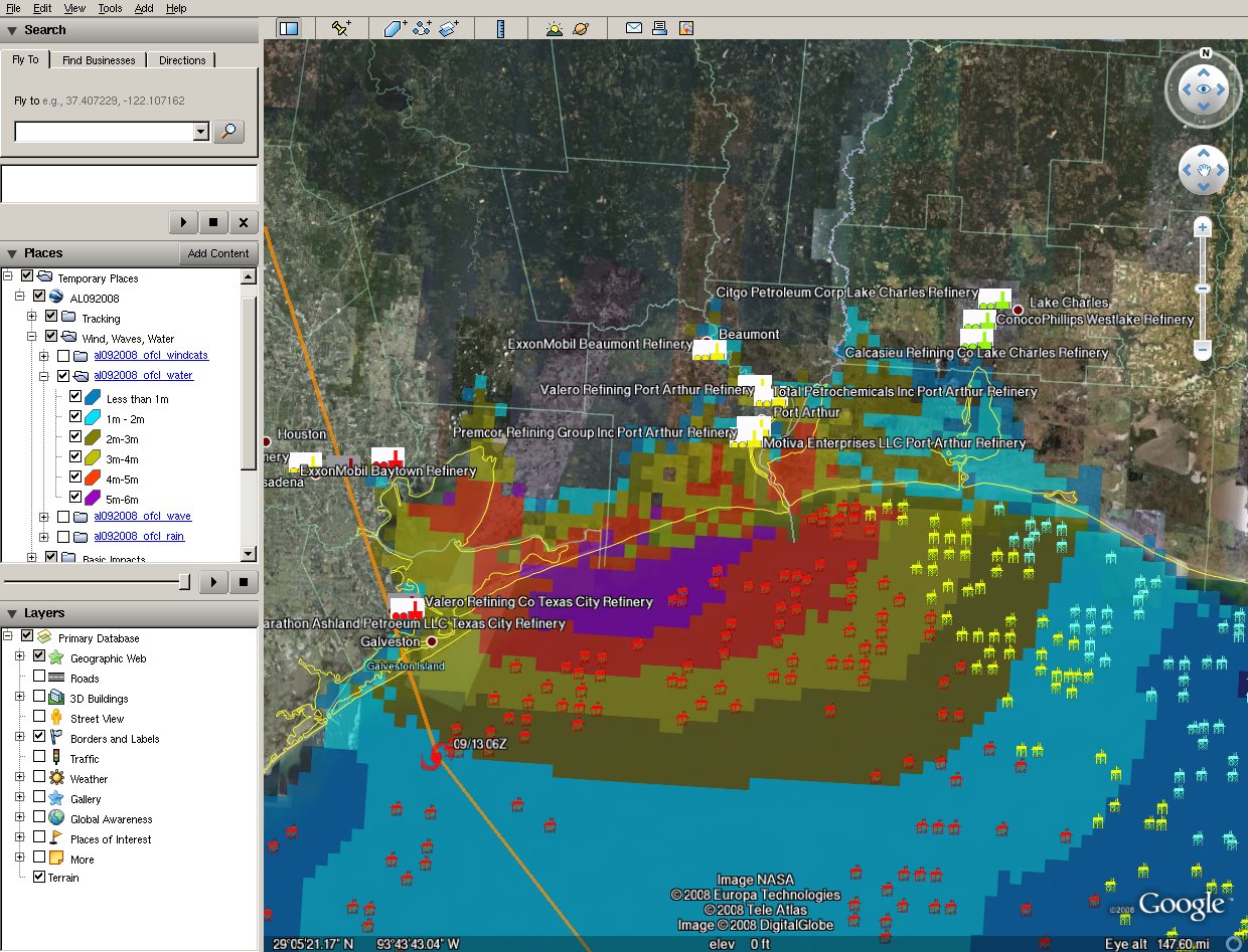
Current path estimates for Hurricane Ike (Methaz NHC official track Sep 12 (17:00 EDT)-click twice to enlarge--colors represent storm surge from SLOSH models, key on the side-you can see it if you enlarge.
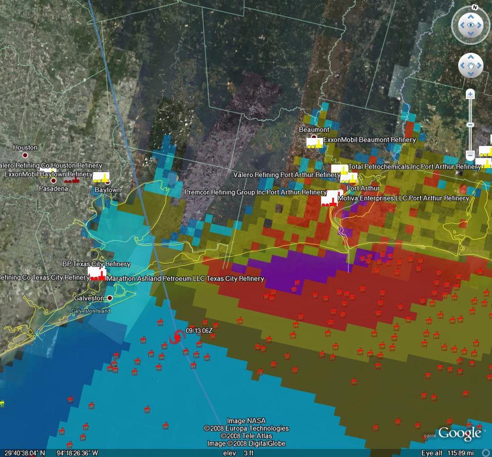
Current track map for Hurricane Ike (Methaz GFDL track Sep 12 (16:00 EDT)-click twice to enlarge--key for the slosh models is in the map above, enlarge it to see them.
For all graphics: Rigs/Platforms: Blue: evacuated only; Yellow will require inspection before restart; Red: damage requiring repair; Refineries: Black: operational impact (partial shutdown) Green: Operational impact (full shutdown) Red: Damage likely; Ports: standard hurricane flags for wind
Here is the latest update from Chuck Watson at KAC/UCF Chuck updating at 20:45 EDT:
Texas City is on the borderline. Water levels still rising, but if the storm resumes a NW trajectory Right Now it might not flood...much.
I don't think Ike is intensifying. Max FL winds on the latest passes were 103 knots, which gives surface winds of 90 knots. Buoy 42035, offshore from Galveston, has been holding steady at 45 knots. Winds at Texas City also holding at 35-40 knots. Water levels at Pleasure Pier are holding steady, and there are *very* preliminary signs the offshore winds at Baytown are starting the drop the water levels there. That's the good news. The bad news is the center of the vortex has been moving due west the last hour or so and is now basically on the NHC track. Hopefully it will turn back NW soon, or water will start blowing into the back of the bay again. Still cautiously non-pessimistic Baytown won't get serious flood damage.
Staying with three scenarios (relative to Galveston):
1) 20 miles west: Very Very Bad for Texas City. Very Bad for Baytown. Pt Arthur some damage but not so bad.
2) Direct Hit: Bad for Texas City, Baytown escapes worst of it. Bad for Pt Arthur.
3) 20mi east: Not so bad for Texas City. Baytown Escapes, Pt Arthur? Oh, you mean Lake Arthur.Remember that swath of heavy damage for most hurricanes, even intense ones, is only 50-75 miles wide. Also recall that damage is exponential - 110 mph winds may be 10% higher than 100 mph winds, but will cause 20% more damage.
as of Sep 12 (16:00 EDT):
Ike remains atypical in structure. Interestingly, the wave and wind fields are stronger on the back side of the storm than in the right front quadrant, due to wind and fetch considerations. The "eyewall" is visible on radar, and looks to make landfall on the north side of Galveston Bay, to the right of the current NHC track. Expect them to shift a bit north in the next advisory. Given this structure, I seriously doubt Ike can intensify much before landfall. However, the wide wave field and potential for 20ft storm surge along a wide stretch of coastline will still cause a lot of coastal damage.
The track and intensity forecast has enough confidence to start looking at very detailed impacts. Offshore, I'm not expecting much damage. The wave field, while extensive, is within the design margins of all but the older, less productive platforms. 30 ft waves sounds like a lot in the Gulf, and I wouldn't want to be out in it, but you have to get above 50 ft to really cause significant damage.
The refineries remain a significant concern. I'm less concerned about wind, unless we get unlucky and something breaks that shouldn't. The big question now is down to flooding, and the main facility I am worried about is the Texas City complex. If the storm tracks to the NE of the bay, and winds blow offshore, it may avoid flooding. But a leftward wobble could inundate this complex, and take out over 1 MMBBL/day capacity for several months. The big Exxon-Mobil Baytown complex is a bit better protected - the storm will have to take a significant leftward jog to flood it. It looks like Port Arthur area is in for big flooding if the current trends continue, but the refineries are further inland, and if the storm starts moving faster there may not be enough time for the surge to build inland.
30 Day Outage Probabilities (Refinery Capacity):
1 MMBBL: 70%
3 MMBBL: 30%
5 MMBBL: 10%
and from Calculated Risk and Tanta, here's a complete geek out for you, which is powered by hurricane-tracking software from Stormpulse.com. Check it out.
Also, the MMS reported today that:
97.5% of the oil production and 94.4 % of the natural gas production in the Gulf has been shut-in; Personnel have been evacuated from a total of 596 production platforms, equivalent to 83.1% of the 717 manned platforms in the Gulf of Mexico; Personnel from 101 rigs have also been evacuated--this is equivalent to 83.5% of the 121 rigs currently operating in the Gulf; that staff has been evacuated from 452 production platforms (63.0%) and 81 rigs (66.9%) – (95.9% of the oil production and 73.1% of the natural gas production has been shut-in as a precautionary measure for Hurricane Ike.)
We will be posting periodic updates of track and damage forecasts here, because one never knows if one of these events will be seminal. We're not hurricane experts at theoildrum.com. Thankfully we have an expert meteorologist who sends us track and damage forecasts relevant to oil and gas infrastructure. What we try to do on this site, (and have been doing for over 3 years), is articulate the fragility and urgency of our nation's, and our world's, energy situation. As Hurricane Ike moves nearer, and professional analysts gauge the impact it may have on our energy infrastructure, feel free to browse our archives of empirically based analyses and perspectives on the many aspects of our energy situation that form the backdrop not only for this hurricane, but for any exogenous event that disrupts the increasingly uneasy balance between energy supply and demand.
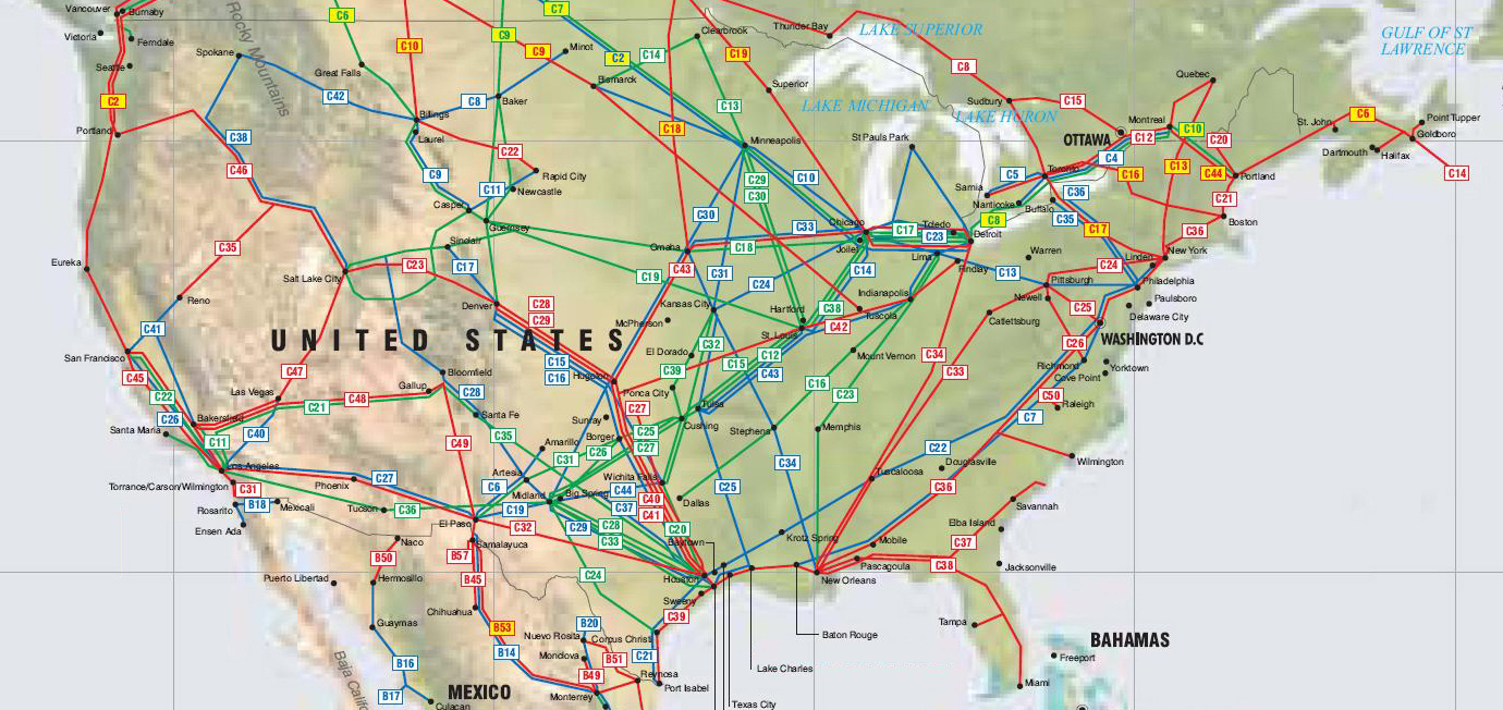
Here is a map of the critical pipeline structure expanding outward nationwide from the Houston/Port Arthur area:
NHC Forecast for Hurricane Ike - click to go to Wunderground
Here are depictions of various Texas cities storm surge maps under different Hurricane scenarios from Weather Underground.
Chuck Watson has put together a dynamically updating page that will reflect the latest damage models/forecasts at this link: KAC/UCF models. We will be updating this thread with damage estimate and breaking news as this story unfolds.
A note on our modeling process: we take the official NHC track, the raw computer model tracks like GFDL, HWRF, LBAR, etc, and even run our own in-house fast cycle track/intensity models. These track and intensity estimates are feed to our main hurricane model (TAOS), which computes the wind, waves, storm surge, currents, etc. at each point in our database of over 50,000 elements in the GoM like rigs, platforms, pipelines, pumping stations, refineries, etc. We then have engineering models for each type of infrastructure that calculates the damage and estimated down time for that element, as well as downstream impacts (eg if a pipeline is down, the upstream elements can't pump and the downstream elements don't get product).
PRODUCTION/INFRASTRUCTURE MAPS AND REFINERY INFORMATION
Here's a link to a really good map of oil refining/SPR storage facilities in respect to the path of Katrina (NB: OLD TRACK MAP!) and here is a listing of production and refining capability for the state of LA.
Just to give you a rough idea of where things are, the map above is a probability swath for Katrina (OLD TRACK MAP!) with the Thunder Horse platform as the red dot, and the other purple dot represents the Mad Dog development (100,000 bd); the Holstein development that produces at peak, around 100,000 bd of oil; and the Atlantis field that may have ramped up to around 200,000 bd in all. Put together these projects have the potential of around 650,000 bd, but as can be seen, they were sitting in an uncomfortable spot relative to the track of the Katrina.The white dot is where Port Fourchon is. This is where the Louisiana Offshore Oil Port, or LOOP, is located. Rigzone pointed out that this is where the foreign tankers offload, Google and Terraserve maps you can see that the area is very low-lying. One of the big concerns is that there will be sub-sea landslides or other ground movement that might affect the LOOP. Were this to be disrupted, then foreign tankers would need to be diverted elsewhere, with the likely port being Houston.
We have accumulated resources from previous hurricanes below, but we'd like to find updated materials if you know of them. Recent refinery maps, recent rig maps in the gulf, recent gas fields, SPR facilities, the Intercoastal Canal, pipeline stations and transfer points, etc., etc. Leave links in the comments please.
Also, here's the EIA's Alabama, Louisiana, Mississippi, and Texas Resources pages. They will also likely come in handy. Also, here's a link to the national page.
Here's another good resource for infrastructure maps and such. (scroll down a bit)
Here's a map from CNN with large and small refineries laid out. (though it is an old storm track)
Very detailed piece by RIGZONE on rigs and other infrastructure in the area. (thanks mw)
Here's a flash graphic of the oil refineries and rig maps from Hurricane Rita, it emphasizes Beaumont and Galveston's importance. Click on oil production in the tab. Note the many rigs on the east side of the storm that will get the brunt of the damage from the NE quad of the storm...hence the high long-term GOMEX oil production damage estimates below.
Here's a link to Rigzone's coverage of Ike.
You want a detailed map? Well here's the probably the best MMS map I could find. Very detailed and lots of interesting stuff. (VERY big .pdf warning)
Also, Scott Wilmoth at Simmons & Co sent us this map on deepwater infrastructure. For a complete list of deepwater development systems (includes operator, depth, location): http://www.gomr.mms.gov/homepg/offshore/deepwatr/dpstruct.html
(Please deposit new relevant links, graphs, and comments in this new thread...we have updated the resources part of this post with new maps and some more old maps and articles from Katrina on the LOOP and Port Fourchon--important parts of the infrastructure, as we learned about three years ago. Please leave personal anecdotes and themes unrelated to hurricane for the other upcoming 'bigger picture' posts, as some of these larger images are difficult to upload for those on dial-up)
We will be posting continued updates of track and damage forecasts here, because one never knows when one of these events may have more than just local impacts. We're not hurricane experts at theoildrum.com. Thankfully we have an expert meteorologist who sends us track and damage forecasts relevant to oil and gas infrastructure. What we try to do on this site, (and have been doing for over 3 years), is articulate the fragility and urgency of our nation's, and our world's, energy situation. As Hurricane Ike moves nearer, and professional analysts gauge the impact it may have on our energy infrastructure, feel free to browse our archives of empirically based analyses and perspectives on the many aspects of our energy situation that form the backdrop not only for this hurricane, but for any exogenous event that disrupts the increasingly uneasy balance between energy supply and demand.i>
Hurricane Ike, Energy Infrastructure, Refineries and Damage Models Thread #4 (Updated 9/12 23:00 EDT)
PDF version
218 comments
Hurricane Ike, Energy Infrastructure, Refineries and Damage Models Thread #4 (Updated 9/12 23:00 EDT)
PDF version
218 comments
Contact
- Content: editors at theoildrum dot com
- Tech support: support at theoildrum dot com
License

This work is licensed under a Creative Commons Attribution-Share Alike 3.0 United States License.
There seems to be disagreement between latest storm surge estimates and the latest track estimates. The storm surge map shows the eye landing east of Houston while most models are still forcasting landfall on the west side of the bay.
As you have suggested, slight variations make large differences in the outcome.
Yeah, the National Hurricane Center's 3-day chart this morning shows a hit just southwest of Galveston. The model runs at the the WeatherUnderground show the same thing. Yesterday's damage projection chart seems to fit this morning's track projections better.
It's too bad the US doesn't have a gasoline strategic reserve. Today might be a good day to make sure your gas tank is full.
Commentary by one of my colleagues, Warren Karlenzig:
"Ike Takes Dead Aim at Houston Ship Channel, Nation's Petrochemical Nerve Center"
http://www.commoncurrent.com/notes/2008/09/ike-takes-dead-aim-at-houston...
Anyone knows to what extent electricity is back in NOLA refineries? Could this lead to simultaneous shutdown of some LA and TX refining capacity?
I was wondering the same thing... With a storm as big as Ike, certainly there will be a huge impact to electricity infrastructure.
Do refineries absolutely require grid power, or can they work with backup power? Are there enough supplies and crews to repair Gustav and Ike damage at the same time?
I suppose Chuck took this into account?
I am not sure about that. Everyone sees Ike as relatively low intensity for winds. Flooding is the major risk.
In such circumstances residential distribution lines are at risk and we should see lots of homes without current due the the large surface covered by Ike, But I would expect high voltage transmission lines to be built to hurricane tolerances in places like Texas. I suspect it would take some major wind force to take them out. This could help refineries to do fine electricity wise.
See my question below: what wave force is the transmission infrastructure rated for? "Flooding" seems like the wrong term- hurricane-driven waves will bring a lot of force to bear on anything solid and attached to the ground.
Gustav managed to damage high voltage lines even at a smaller size and being a Cat 2 storm at landfall. Ike is much bigger and probably a Cat 2/3 at landfall.
I follow you. I would expect people NOT to build their homes on the very beach of Texas, due to .... you know.BTW which insurance company do they use?
Yes, however, the substations and other equipment are still on the ground. I've seen flood remediation work on flooded homes. Basically, ALL the electrical stuff that gets wet has to be replaced. The water carries dirt and grit that settles into everything, and makes future use of the electrical equipment dodgy.
When the ground turns to soup due to flooding, its hard to keep things standing upright even in 50mph winds.
That logic goes for coastal areas. In land it is another story.
In related news Jeff Masters now predicts the largest power failure in the history of Texas. He knows far better than me. I will crawl back under my soap box.
As of a couple of days ago, 11 of 12 refineries had grid power (sometimes one tie where they had two before).
Since I have heard nothing, I assume all are now happily refining away.
Alan
Alas, this is not the case. Based on what I know, some (maybe most) refineries are on "hot standby". Ike is causing nat gas supply issues due to evacuation in the Henry Hub area. Also, most refineries cannot run on internal power even if they have cogeneration capabilities. They usually require grid connections.
Stupid is as stupid does
One way grid sucking is old school , Why not contribute
to the stability of the grid instead of cratering it. Electrons flow to where the customers & dollars are.
Lot's of fumes to run these plants on AND help support LOCAL grid infrastructure.
But no, we have to pay for stranded costs,
Market now demands the cleanest electrons . FIT's (Feed In Terrifs) needed, but often not possible even on the mega-watt level, must import kwH from hundreds of miles away. In the early 80's we did auto transfer (grid drop )for safety and obvious reasons on Hydrocarbon complexes. We had to have a battery room for transfer to keep the brains up, but today required battery's could fit in a Yukon (or even Prius) instead of bunkers. So the up issue should not be the grid. But it may be to dated
designs
The newscasts from Houston reported that the Coast Guard has decided a rescue is too risky and the crew is on their own.
FWIW, reports now are that the freighter managed to make it through Ike and will be towed by boats out of Corpus Cristi. The crew is fine. Good news!
Zoinks Scoobs!
Already slashing over the galveston wall, at low tide, and the storm is 200+ miles away.
I see on the weather channel that nature is already selecting gene pools for termination. "Hey kids, climb on that wall and I'll take a picture of the hurricane washing you out to sea".
At still no shock in the oil markets, even with the dollar dropping.
It seems that there will be more impact to refineries than to oil production... Without refineries, oil is no good.
I understand that, but that's short term. When the refineries DO start up, all this off-line oil, plus the Loop being Closed again, plus POH being closed, plus the on-shore fields not pumping due to no electricity...
It's a long list, and people in California and New York are still driving away.
Let me remind that Gustav took out the refineries as well, but oil inventories still when down 5.9 million barrels.
On another note, South Texas Project Nuke making plans to shut-down.
http://blogs.chron.com/hurricanes/2008/09/south_texas_project_nuclear_pl...
Today in the Triangle area (Raleigh, Durham, Chapel Hill) some stations are requesting that people limit their gasoline purchases to 10 gallons as the gas supplies are being stretched AND the anticipated impact of IKE on refining capacity.
Same thing happening in North Alabama area (Huntsville)
Ditto for north Georgia
As a follow up: I went and filled my tank (it was half full) this morning. Price: $3.69/gallon. This afternoon I passed the same station: price $4.29/gallon. Same across the street, while in one direction that gas had gone up from 3.67 to 3.89 and in the othe direction from 3.79 up to 3.99.
AG's office has put these folks on notice about price gouging (e.g., you better be able to show the invoice with the wholesale price that justifies this price).
I read a story online today (I cannot find the link ATM), about gas shortages in East TN. Supposedly, they were due to a wreck(s) of trucks carrying fuel.
In addition, my brother informed me around 8 PM EST tonight that he could not find gas around Brentwood, TN. He called me wondering WTF?
I suggested for him to top off his tanks prior to Gustav hitting (when it looked like it might significantly strengthen prior to landing), which he ignored.
He now seems more concerned about the details after I informed him that 30% of the US refining capacity might be offline shortly.
There are no apparent supply issues in the Columbus, OH region at this time (my local).
We do live in interesting times...
Which refinery regions can the SPR supply (through pipelines) besides the local ones? I believe I read last week that the SPR would supply 250k barrels of oil to Marathon's Kentucky and Illinois refineries.
One of 4 SPRs, the one 40 miles north of New Orleans, has access to Mississippi River. Other three (AFAIK) have access to Intercoastal Canal and rail access for all 4.
Post by Rockman on #3 thread that deserves reposting, IMO (emphasis added)*
http://www.theoildrum.com/node/4517#comment-406549
*Even though he has said unkind things about exploration geologists in the past
With waves atop standing water, what physical damage can we expect on the refineries? I understand that there are wind damage specifications, but what about wave damage? New Orleans is not a good reference, it seems, as the flood waters came in after the storm had passed; Texas City facilities will be facing some rather large and powerful waves on top of the surge. Can anyone comment on the seaworthiness of land-based infrastructure?
I would expect houses to be pushed off their foundations. In addition to the wave energy there will be a debris field riding in the waves and this will be carried inland and cause damage to structures on the edge of the new surf line.
The retreating waves will also cause scour and this will undermine a lot of infrastructure as my understanding is that Galveston is sitting on a barrier island which is primarily sand.
I would also be concerned about the refinery tank farms if they are exposed to prolonged wave strike.
The tall structures in Houston will be tested and any communication towers on their tops will likely be carried away and cause secondary damage. Last time I saw 100K winds they blew the anemometer off the masthead and the force of the wind pretty much curtailed all forward advance. This event will not be pretty.
Down the delta the water and wind were acting together and where houses were not on stilts they were gone, where the storm was most severe.
The Weather Channel guy estimates that the evacuation percentage on the west side of Galveston Island is about 80%, but he puts it at only about 30% to 50% on the east side. Homes are already flooding on the west side.
They are reporting (at 9:50 Central) that there is already water over a seawall in Lake Charles, LA.
This e-mail came at work yesterday afternoon from the office park management:
So the (well-founded?) rumors are going around town, although no notice by the local news media. As a consequence, my car-pool buddy says she had to go to three gas stations last night before finding one that had gas and a reasonably short line. Is this the start of Simmons' "Run on the Bank?"
I'm in California, and I just topped off and filled the cans. I called in all my daughter's prescriptions as well. You just never know.
The peak of Hurricane season was only two days ago. That means the other half of the season is just beginning. Plenty of October hurricanes on record.
This is probably futile - DON'T STORE GASOLINE ANYWHERE NEAR WHERE PEOPLE LIVE.
Gasoline is very dangerous, and the number of people about to discover this truth is likely to increase dramatically in the U.S. - tragically.
This is another example of what I meant by fact resistant.
Don't store gasoline - especially don't store gasoline in enclosed spaces.
when you pull your car in to your garage connected to, or below your living space, aren't you effectively storing many gallons (10 or more) of gasoline near your living space?
Im in Cali, and as of this morning gas prices were still at a several month low. We tend to be not too affected by GOM problems, as our gasoline is refined locally, I expect some price runup, but probably a lot less than the central and eastern parts of the country.
Maybe, the good thing about Ike, is that he should have used up much of the excess ocean heat content in the gulf. If that is true -maybe the experts can chime in here, maybe we've seen the last big GOM cane this season.
I thought about filling my tank last night, but even this morning, gas prices are lower than they've been in months (Kansas City). Not sure how that lines up with $5 spot prices...
Thanks to all of you spread who spread around this and other work The Oil Drum around to your friends, the web, and to other discussion boards. We do appreciate it.
Also, we're on twitter: http://twitter.com/theoildrum
That's one way of looking at it. A hurricane with a very tight pressure gradient in the vicinity of the core is likely to have much faster winds, but with a narrower reach (generally speaking, when the pressure gradient is doubled, the average wind speed also doubles). Ike currently has a central pressure similar to what Charlie (2004) had at landfall (941 mb for Charlie). In the case of Charlie, the region of very low pressure was much smaller; therefore surface pressure gradients were much higher (meaning higher winds, but in a smaller region). Here's a rough diagram to illustrate the difference:
-best,
Wolf
Here is the prognosis for the Eastern US:
http://www.trforum.org/journal/2005sum/article8.php
If the Houston oil terminals are closed, Port Fourchon is closed, and the refineries shut down, I guess there's always Europe.
Another piece of data:
Whose bright idea was it to put Texas and Louisiana right next to each other on the map?
Hey, let's put the LNG receiving stations there too!
Everyone else says NIMBY to new LNG facilities in their ports.
Alan
Well duh! Energy infrastructure apparently attracts hurricanes and who needs that?
Guess what else is in Texas - Galveston, specifically?
Post
Luckily I researched this a bit more, and the site hasn't finished construction and has no actual pathogens on site - I hope.
Construction Schedule
Politics make for some bad decisions...didn't they read 'The Andromeda Strain'? Put your BH 4+ facility underground in North-West Nevada...no Hurricanes, no fires, minimal earthquakes, no people...oh, that last part would be tough, unless you can convince all your top scientists to live in Elko and Ely and commute.
Exactly, also I assume that part of the function of this lab will be testing of suspect specimens from sick patients. This requires proximity to them i.e. to major hospitals and courier hubs (airports) as rapid turn around time is critical to patient care, and in many cases these bugs need to be cultured quickly after collection from the patient to remain viable.
This is a medical research and testing lab, not a bio-weapons production facility. It will be dealing with comparatively tiny amounts of organism. The primary threat on a day to day basis is to the folks who work there if something serious was to go wrong.
Man. It does seem like a kinda dopey place to put a lab like that.
A very brief blurb on CNN minutes ago indicated that "a lab in Galvaston was evacuated and all [microbes] were destroyed [on purpose]." Don't know if this was the specific lab and they did not indicate it was a BSL-4. It did perk up my ears...
From iReport.com (a darn good place to follow these events real time):
NC with fuel shortage today?
SC certainly has problems
Also in Indiana
Hurricane hunters report the storm strengthening
Food shortages in Texas
I see the Hurricane Hunter P3s still have their MAD attennas attached. I guess we look for Subs and Hurricane's at the same time. Seems Bush has taken the search for WMD to include Weather of Mass Destruction.
U.S. Refiners Accelerate Closings as Ike Strengthens
Oil industry hunkers down
There are already runs on gas stations. A sampling:
The Gas Panic is Alive (Georgia)
Knox hit with gas shortage (Tennessee)
Ike effect: Run on gas begins
Gas prices will spike as Ike nears U.S.
Refinery closures squeezing drivers (Indiana)
Fuel Price In Texas Jumps Due To Surge In Demand Caused By Residents Fleeing Hurricane Ike
As Ike nears, chain asks for limit on gas buys
Panic at the Pumps?
Emergency chiefs urge halt to local gas run
Dan Pickering on KHOU reporting that shut-ins will affect off-shore platforms but no damage reported yet. Not clear what he is basing that "no damage" statement on- is there real-time data coming from off-shore platforms?
1-3 weeks of refining off-line, according to Dan. Showing video of tanker trucks in CA lined up, presumably to take deliveries East?
Four simultaneous video feeds for those with ADD and broadband here:
http://www.maroonspoon.com/wx/ike.html
Here is Ike's history up to the 1200 UTC, 12 Sep 2008 NHC statement:
Ike apparently has gained some in maximum wind speed, up to 90-kt, but central pressure is up about 10 mb over recent lows. Central pressure is also varying a bit between observations.
Buoy 42001, located at 25.9ºN and 89.7ºW, ended up fairly close to Ike's center. Lowest pressure was 959.7 mb (28.34"). Maximum winds were 68 mph gusting 87 out of the south after Ike's center had moved to the west. This buoy has an ARES payload, so the sustained winds are an 8-minute average. Adjusting to 1-minute, which has been the standard indicator for hurricane strength (and a 2-minute wind is typically lower than 1-minute by about 5%, so generally not much different), max winds were probably in the range of 75-80 mph. Still a bit short of the 100-105 mph being estimated for the storm. The maximum winds likely skirted Buoy 42001.
Here's Ike's forward speed:
Ike continues to accelerate as it approaches Texas.
And here is Ike's track compared to Gustav's:
Looks to be closing in on Galveston, TX. If the storm's direction doesn't shift much, then, by this diagram, Ike would land just west of Galveston.
-best,
Wolf
KHOU reporting on tug boats pushing together barges and tethering them together in open water in bays and channels, the barges (according to reporter) carry petrochemicals. They noted that barges pushed around by Katrina created some damage to land-based structures and that the barges themselves aren't sea-rated, contents will likely be lost. The reporters in the studio expressed skepticism that tethering them together will make much of a difference.
Edit: what size of barge impact do you suppose the infrastructure is rated to handle? My guess is that a 40' pleasure craft can take out a powerline. An 80 foot barge versus a refinery?
That's scary.
If that gets into the tank farm then you are going to have product riding on the waves as well.
Have this google map of sea surface levels
http://flood.firetree.net/?ll=29.5388,-95.1430&z=7&m=9
Water height was set at 30 feet = 9m but this is a static height and does not reflect wave action.
There is a tank farm at Texas City which appears to be at risk and another up at Baytown.
The sea surface map does not appear to permit zooming in for a closer view but the main google map pages do permit that view. This URL may work:
http://maps.google.com/maps/ms?ie=UTF&msa=0&msid=108513504067703959829.0...
According to the guys at storm2k, the latest recon flight found flight level winds of 114 knots, which supports surface level winds around Chuck's magic level of 100 knots.
Chuck just sent me this 11am update:
Steve Brown KSAT--ABC affiliate from San Antonio says the eye is tightening as the storm approaches the shore. Last official wind speed up to 110 mph (one mph shy of Cat 3).
PS. He also said the storm continues tracking to the West--bad news for Houston/Galveston.
SLOSH from over at WUnderground/Masters' blog:
ftp://ftp.tpc.ncep.noaa.gov/surge/Latest/i46_gl2_EOHW.gif
From Masters at WU:
"The situation is grim for Port Arthur, Texas, on the Louisiana border. The expected storm surge of 15-20 feet will overtop the city's seawall by six feet, resulting in flooding of the city and a number of major oil refineries. Expect a significant tightening of gas supplies in coming months, due to extensive damage to the oil refineries in the Houston and Port Arthur area."
NB: If you're still on the north Texas coast, you're a fool. Storm seems to be weakening, but don't bet your life on this stuff!
Recon is finding increasing winds, not decreasing. Some recent readings suggest Cat 3 now. Ike sems to be having one last try to fully spin up. Massive convective burst just now.
Dry air entrainment is a complex issue. It actually makes forecasting more difficult, for, if core collapse is induced at the right (wrong) time, say as the storm is moving ashore, surface conditions on land can be much worse than they would have been otherwise. A collapsing core can result in significant downbursts. Momentum mixing from the mid and upper atmosphere in these downbursts can increase windspeeds at the surface (locally). Also, rainfall rates can be much heavier. In fact, dry air entrainment by itself may not be enough to weaken a hurricane significantly: Some models indicate that all other things being equal (surface water temp, windshear), a hurricane can sustain itself while entraining dry air. Water temperature is by far the most important factor in hurricane strength (a meager ~ 2-3 K drop in water temp can shut a hurricane down fairly quickly), with perhaps wind shear being the next most important consideration.
It's good to keep in mind the whole concept of extratropical transition (ET)--the transition from warm-core hurricane to cold-core midlatitude weather disturbance. There are, indeed, gray areas between "hurricane" and "extratropical cyclone." As a hurricane approaches a significant landmass, the storm begins to take on cold-core characteristics (such as dry air entrainment), sometimes slowly, and sometimes more quickly depending on many factors. This is so common that it's essentially part of the hurricane climatology for places like the Gulf Coast. Keep in mind that Camille landed as a Cat-5, this despite the likelihood of significant dry air entrainment. Most landfalling GOM hurricanes for which we have good data show characteristics of dry air entrainment. Nevertheless, some of them end up being real monsters.
-best,
Wolf
I just talked 10 minutes ago to my good friend who is now staying put in Galveston holding the fort as this tropical storm passes. He also confirmed as a fact that most of his neighbors and most of the towns people have not evacuated. He said he thinks about 1/3rd of the towns people have fled and he estimates about 2/3rd are holding down the hatches.
They are going to get water and many have been working with sandbags. My freinds suburb most residence are staying put..this burb is about 3-4 miles west of Galveston downtown area.
Its not only him who is stay put in Galveston...Most people there are..and I agree with their decisions! This is not a CAT 5 storm..if they can tread the water they will be fine!
I suspect treading water in the face of 90mph winds and 20 foot waves will be an experience of a lifetime, if you survive.
With these stats:
I estimate that there will be 40,000 people treading water (or maybe just bobbing around).
History of Glaveston Sea wall. I really hope 17ft is enough.
http://www.therealgalveston.com/Seawall.html
Marco.
Jeff Masters:
http://www.wunderground.com/blog/JeffMasters/comment.html?entrynum=1082&...
Flooding is no joke. We lose people to comparatively benign river flooding all the time, anybody staying in Galveston who doesn't have hurricane-resistant shelter well above the 15' surge (that's 2 stories up).
4th floor or higher in a good solid commercial building inner stairwell is where I would be in these circumstances, and I would be worried even there.
Anybody planning to ride it out at home? My sympathies to their family and friends.
this burb is about 3-4 miles west of Galveston downtown area
Outside the seawall.
RIP
Alan
Sandbags? Dude.
agreed, sandbags wont help .
Go for banners, alot of "Go away Ike"-banners, mirrors and garlic.
You are either a troll or insane - or both.
He's a high school student in Peoria.
If you hurry, perhaps you could join them in Galveston?
Hurricane Ike pushes sea onto Texas island
This must be your friend:
The demographics of floating dead bodies will change :-(
Alan
A U.S. military official told CNN that Texas anticipates 37,000 people may need to be rescued.
Many thousands of those "rescued" will need body bags.
After the last Galveston hurricane disaster, civilians were impressed at gunpoint to bury the large # of dead bodies.
Based on the storm surge that we are seeing (6' deep water in Port Fourchon latest report, multiple levee breaches) off the track with minimal winds, I fear for those in the Galveston Bay area.
Alan
Whomever marked Alan down simply does not understand what it is like to attempt to survive this kind of storm.
Hypothermia will cause loss of consciousness within an hour of immersion and impair reason well before that.
The water will contain debris and this will impact persons in the water.
Wave action will propel persons in the water against structures.
Too many people will be thinking "this is just water" and will over estimate their ability to survive.
And if the debris hitting you doesn't kill you, the sewage and chemicals will.
Not a good sign: Channel 11 in Houston is reporting that the Coast Guard has already received over 150 calls requesting emergency evacuation--with the landfall still over 12 hours away.
I was going to comment about the kayaker - fact resistant doesn't even begin to approach his mental attitude.
I wish no one ill, especially blameless children, but sometimes, letting people take responsibility for their stupidity is the only way to help the survivors learn.
He is a dead man floating, unless fate plays some bizarre twist in his case.
'Despite his initial "It's just water" bravado, Taylor changed his mind a short time later and left, to the relief of his wife, Elizabeth, The Associated Press reported.'
Saved from his own idiocy - just another data point that married men live longer.
We all make mistakes - he had a chance to recover from his, before he made it.
OK, so some moron in Galveston was talked out of committing suicide by Elizabeth Taylor? You can't write this stuff.
Hilarious!
this thing is enormous ! .... And as for Mr Taylor "RIP to you old kayakwizzard"
People are obviously fooled by the "low category" thus far, but the inertia in this storm is beyond many cat 5's. Some place I read that the surge in Alabama already was higher than the stronger and much closer hurricane Gustav.
The water will be piling up , and up and up . Nowhere to go but up.
EDIT *** A congressman said just now at ABC that "Galveston will become an integrated part of the GOM"
'Floodwaters surged into Galveston Island neighborhoods Friday morning with the center of Hurricane Ike still more than 200 miles from landfall.
Waves washed for blocks inland, the beginning of a storm surge that forecasters warned could reach up to 22 feet and bring "certain death" to anyone who remained in Galveston Bay homes.'
http://www.cnn.com/2008/US/weather/09/12/hurricane.ike.texas/index.html#...
'On the Bolivar Peninsula, northeast of Galveston, the Coast Guard was using helicopters to rescue stranded motorists.
A U.S. military official told CNN that Texas anticipates 37,000 people may need to be rescued.
Texas has asked for help, and the active-duty military has 42 search-and-rescue helicopters on standby, the official said.'
http://www.cnn.com/2008/US/weather/09/12/hurricane.ike.texas/index.html
You realize that 42 helicopters just might be able to airlift a few hundred people an hour, assuming heroic efforts - including logistics which can keep them in the air for days without problem. Because the Navy aren't going to be in the area for at least 24 hours - even a Nimitz class carrier can't do flight deck operations in 70 feet waves.
A lot of people are going to die - welcome to the real world. The children aren't to be blamed, but then, natural catastrophes don't have age limits.
The only difference between New Orleans and Galveston is that in New Orleans, people are now scared of hurricanes. No one in Galveston remembers 1900 - but the survivors on Galveston Island now are likely to never forget 2008. Whether they will ever live in Galveston again is another question.
The only difference between New Orleans and Galveston
In New Orleans, if the US Army levees had performed to design criteria, a half dozen to a dozen people would have died within New Orleans proper.
The design criteria for even the Galveston seawall will be exceeded by a large margin. And there is literally no protection for the suburbs outside the seawall (some private sea walls of 3 and 4 feet from memory).
Alan
Not to get too specific, but I thought the loose barge played a major role in some of the flooding, though probably not too many fatalities.
And though it wasn't clear, I was referring to how New Orleans handled Gustav, due to the recent experience of Katrina, compared to the obviously unknowing residents of Galveston. I'm pretty sure that New Orleans will also handle the next hurricane pretty well, for that matter. It is possible that there won't be enough left of Galveston to make it worth rebuilding, which would make Galveston's future response to hurricanes moot.
Quite honestly, I'm not sure that a lot of those people still have a window to escape at this point - I think there is probably more damage to the various parts of the road network/bridges than they are aware of.
Anyone familiar with the Outer Banks NC in general probably understands what this means - roads built on sand don't last well underwater.
GeneralGreen...your good friend is an imbecile. Call him back and tell him we'll put his name on the list...along with his neighbors...for this years group Darwin award.
I suspect GeneralGreen is pulling a prank to get everyone riled up. My grandparents evacuated yesterday... it's a ghost town. Nobody, certainly not anyone in Galveston refers to the west side of Galveston as the suburbs... Galveston is a small town (60k)... it IS a suburb. Not to mention Galveston doesn't really have a "downtown", and even if he's talking about the strand, 3-4 miles doesn't even get you to 61st st.
TV reports keep saying 24,000 people have stayed in Galveston. One of the reporters really looked quite ill when he kept talking about all the people who stayed. I kept getting the very strong impression that he wanted very badly to ask someone if any of those people were going to survive.
I stand corrected.
http://www.theoildrum.com/files/united_states_pipelines_map_sm.jpg
US 90 closed in Bay St. Louis, Mississippi due to storm surge.
Never ending tornado warnings, much more than fro Gustav.
(In 1800s, before modern meteorology, I would be more concerned with Ike than last week here in New Orleans).
Terrebonne and Lafourche Parish officials are "not available" for news media, too busy.
My guess is Port Lafourche post-Gustav repairs (except electrical) will be undone and more damage.
Winds appear to be causing only sporadic power outages in SE Louisiana.
Alan
The Red Cross is opening shelters in South Louisiana for families that were flooded out by storm surge.
Hi Alan,
At Pilot's Station East (PSTL1), sustained winds reached 50-54 mph at times, with gusts upwards of 70 mph. Winds regularly exceeded 40 mph for over 16 hours. And at New Orleans International (KMSY), winds have occasionally reached potentially damaging levels: ESE 40 mph gusting 58 at 0716 CDT today, during a heavy thunderstorm that dropped 0.59" of rain in about a half hour. Following this has been a steady stream of ESE-SE gusts of 40-52 mph over about the last five hours. The naval air station (KNEW) reported a gust to 69 mph at 0545 CDT. That's almost as high as the maximum gust during Gustav for this station. These kinds of wind speeds can certainly be disruptive to electrical infrastructure, though in most cases wouldn't cause catastrophic loss. Utility poles that may have been weakened by Gustav could succumb to such wind speeds.
These wind readings are quite fascinating when one considers how far away Ike's center is from southeast LA. Ike has quite a reach.
-best,
Wolf
The airport is in Kenner and is in an exposed position and routinely has higher wind speeds (and lower rainfall) than Urban New Orleans.
Weatherbug has several stations near me and I prefer them for "real" readings that affect me.
The storm surge, much more than the wind, has truly impressed me !
No reports of power outages (I was out for 15 minutes twice last night) and apparently not a big deal. Very close to the coast, reports are still sketchy (they are worried about levee failures).
Alan
This link goes to the National Data Buoy Center's page for the Western Gulf. The inset within the map for Galveston Bay will be of interest during landfall. As you might expect, some of these weather stations are located on drill rigs.
Hello TODers,
Cool photo of Ike taken from the Space Station far above:
http://news.yahoo.com/nphotos/Galveston-Gulf-of-Mexico-NASA-Internationa...
Looks like breaking tsunami waves, but those are just clouds!
Anyone know of links to the HiRes versions ?
The ones of Ivan taken from the ISS were breathtaking.
Some damage to docks here in Pensacola, as well beach
erosion.
NASA:
http://www.nasa.gov/mission_pages/station/multimedia/index.html
Here's a direct link to the hi-res version. (Warning: it's bloody huge.)
Confirmed: Levee overtopped but not breached in Lafourche Parish (access to Port LaFourche) by storm surge.
AFAIK, this levee was not breached during Gustav.
Any readings on storm surge Gustav vs. Ike in South Louisiana ?
Alan
This weather station,incidentally placed on an oil platform is taking a beating:

This one near Galveston is seeing wave height of 20ft already:
http://www.ndbc.noaa.gov/station_page.php?station=42035
Here is the situation at Galveston:
The surge is already around 6 feet, other stations here: http://www.ndbc.noaa.gov/maps/Galveston_Bay.shtml
Galveston Bay buoy reports 17 to 19 ft sea at 1150 CDT
5-day plot - Wind Direction Wind Direction (WDIR): NE ( 50 deg true )
5-day plot - Wind Speed Wind Speed (WSPD): 27.2 kts
5-day plot - Wind Gust Wind Gust (GST): 35.0 kts
5-day plot - Wave Height Wave Height (WVHT): 17.1 ft
http://www.ndbc.noaa.gov/station_page.php?station=42035
Gosh, I do like buoys. Alan, here's the direct link to the near and onshore stations for SE Louisiana and SW Mississippi. Unfortunately, there are several offline. Marsh Island is currently reporting waves at 17+ feet.
Same station at 1250 CDT
5-day plot - Wind Direction Wind Direction (WDIR): ENE ( 60 deg true )
5-day plot - Wind Speed Wind Speed (WSPD): 33.0 kts
5-day plot - Wind Gust Wind Gust (GST): 40.8 kts
5-day plot - Wave Height Wave Height (WVHT): 19.4 ft
Same station at 1350
Wind Direction (WDIR): NE ( 50 deg true )
5-day plot - Wind Speed Wind Speed (WSPD): 35.0 kts
5-day plot - Wind Gust Wind Gust (GST): 42.7 kts
5-day plot - Wave Height Wave Height (WVHT): 16.7 ft
5-day plot - Dominant Wave Period Dominant Wave Period (DPD): 15 sec
Same station at 1450 CDT
5-day plot - Wind Direction Wind Direction (WDIR): NE ( 50 deg true )
5-day plot - Wind Speed Wind Speed (WSPD): 38.9 kts
5-day plot - Wind Gust Wind Gust (GST): 46.6 kts
5-day plot - Wave Height Wave Height (WVHT): 17.1 ft
This station is about 20 miles out in Galveston Bay.
quick link to water height on Galveston sea front:
http://tidesonline.nos.noaa.gov/plotcomp.shtml?station_info=8771510+Galv...
The Hurricane of 1900 wiped out Galveston (http://en.wikipedia.org/wiki/Galveston_Hurricane_of_1900), the surge was around 15 feet.
Just looked at the 42361 data from the link - check the wind speed and heat index: +91knots and 92degrees.
That is just insane!
Confirmed: Levee overtopped but not breached in Terrebonne Parish @ Chauvin by storm surge. Not that far from Port Fourchon.
AFAIK, this levee was not breached during Gustav.
Any readings on storm surge Gustav vs. Ike in South Louisiana ?
Gov. Jindal stated that surge in Port Fourchon is near or at peak, but will take a day before subsiding. MUCH longer than for Gustav.
Gov. Jindal - Confirmed breach of levee in Laforuche Parish, no details
In SW Louisiana, National Guard deployed in high water trucks and State Wildlife in airboats and will evacuate anyone that requests till 2 PM. 5 feet of water on one road already.
Gov. Jindal has authorized citizens to break into state property if they think that they will be safer there. He requests that do a minimum of damage while sheltering there.
Alan
Alan-
According to Weather Underground, NOLA is within the range of tropical storm winds. Is that what you're currently observing?
http://www.wunderground.com/tropical/tracking/at200809_wind.html#a_topad
Weatherbug station 6 blocks away has 17 mph winds from due North. Highest today 40 mph ESE (yesterday 56 mph). Clearing skies, Ike is over for us once storm surge goes down.
Plaquemines Parish (East Bank of MS River, at end/toe of LA) just reported levee breach.
Alan
Reports say water is up 6 feet at Mobile, 5 feet at Pensacola. Here in Destin, Fl its up 3 feet. Quite a storm.
Reports of Cameron, La and parts of Sabine Pass, Port Arthur being underwater from hurricane Ike storm surge.
Edit: Police report LNG facilities in Sabine Pass are under 4ft of water and are expecting a 15ft storm surge yet to come. All facilities at Sabine Pass have been evacuated.
Local hurricane news http://flhurricane.com/ikecoverage.html
The coverage of Galveston residents gawking at the waves, taking cell phone pictures, etc. is quite amazing.
I'm watching live video of the Balinese night club built out on a pier at Galveston. the waves are already starting to take out this huge structure and the storm is still 9 hrs away. It leaves me beyond words that people will invest their money on the edge of a sandbar in a hurricane zone. I've also heard via CNN that only 25% of the people on that sandbar have evacuated.
We often speak of moral hazard, which is aiding and abetting stupid behavior. What really jerks my chain is that these enormous losses will be socialized through a nation that has become a giant insurance company that insures against -- I won't say stupidity, because its beyond that -- its INSANITY. If another 6,000 people die on that sandbar, my reaction will be "good riddence." This kind of behavior is suicidal.
The NHC has just issued a warning that anyone staying on that sandbar will likely die.
Its about time that all insurance, support and assistence to people who want to live on the edge of disaster and death be withdrawn.
According to a local official some 14500 people remain on Galveston Island. Ignoring warnings that they face certain death if they remain.
Problem is the people either die or the credibility of those giving the warnings will die if no one is killed.
Unfortunately, the deaths are pretty much guaranteed - the Coast Guard is already rescuing people from cars. It will only get much, much worse.
This isn't a Hollywood movie - there will be heroic rescues, but not in the thousands, and definitely not in the tens of thousands.
[edited to delete flippant remark inappropriate to a grim situation]
Gee, I'd have enjoyed hearing it.
Truely there is too much of an effort to protect people from themselves and then have others bear that cost.
IMHO, too much TV makes people believe someone will always be there save them. And they die wondering what went wrong...
I agree. Having CNN, TWC, and other "news" broadcasters staked out on the shore and saying they feel safe because they are staying in the confines of the local emergency response shelter is actually very unresponsible behavior. But we should understand that this ought to be expected by "news" organizations that play up anything spectacular and bizzare and display the if it bleeds it leads mentality. When I was in Houston for ASPO last year, I drove to Galveston specifically to view the vaunted seawall, etc. Based on that, I would be long gone for Ike if I lived there.
Oh please. Blaming CNN and TWC?
All the smart people know what a hurricane does and the stupid people can't afford a TV anyway. TWC pictures are their to scare the crap out of people and most people get it. I'm 2000 miles away, only saw one hurricane, Alecia, and I clearly understand that one should get the hell out of the way of a hurricane.
CNN shows pictures of Iraq, too, but I have no desire to stay there either.
It is a bit inconsistent to keep saying "if you stay you die" when they, in fact, stay. I guess they wouldn't pay Anderson Cooper's insurance premium, he's in downtown Houston, leaving Galveston for the reporters that don't get paid as much.
It is not inconsistent to say, "If you stay in your 1 or 2 story home well below the level of the storm surge, you will die" while saying such from an 11-story hotel built to withstand such storms.
crikey...
I know a lot of "stupid" people who own TVs, usually the biggest possible. When watching TWC, there are always folks playing around in the surf zones in total contradiction of what's being said by the announcer. Lots of folks who've been through previous storms think they're quite "smart" and stay on. I stand by my statement that this is done as entertainemnt--to make money for the broadcasters. There is no public interest involved despite what might be said--like bringing "democracy" to Iraq.
I should add that I live on the edge of the Pacific Ocean and experience cat-1 to cat-2 storms every winter. I know very well the power of Nature; we have people die off our coast here every year because they don't heed the warnings like those made by TWC commentators.
http://cnnwire.blogs.cnn.com/2008/09/12/19-year-old-dead-in-texas/
A lot of the places that were evacuated were too dangerous even for reporters.
I don't think people really understand how powerful these storms can be. You'd think they would, living right next to the ocean, but they don't, as evidenced by Mr. Kayak's "it's just water" comment.
This morning on CNN, they were talking about a family that had to be evacuated via boat, because they waited so long the road was washed out. The CNN reporters asked the teenage daughter why they waited so long, and she replied, "I don't know."
So they asked her father the same question, and he said, "I don't know. The surf was really good."
Ye gods. Kids can be stupid. (I remember riding my skateboard during a typhoon once. At first it was really cool. I was flying down the street...uphill, without having to push. But I started reaching scary speeds as the storm picked up, and I went back inside.) Dunno what the father's excuse is, though.
Watching these folks driving up to the wall, smiling, chatting, I think, this is all old song:
I think that's a poem by Byron? Keats? One of those romantic cats.
Houston TV reporting that Galveston jail, on the island, with about 1000 prisoners, is not being evacuated because of security concerns....
Now that will be an interesting class-action suit...
interesting that they didnt relocate the prisoners.
Those jailbirds are going to have one very eventful day.
Or that's what they told told the press.
They actually said that the safety of the prisoners was their first priority, but that they would not talk about evacuation plans, for security reasons. They did the same thing during Rita. Said they weren't moving them, but did in fact move them.
Oil infrastructure can be repaired. Human life cannot. From a peak oil perspective this has little relevance other than to get a glimpse of how panic plays out. That may be the bigger lesson that storms like this can teach us. Short term (emphasis SHORT), people can deal with the price spikes.
Human nature when pushed to it's limits is very nasty, just like Katrina demonstrated in NOLA. What happens when the shelves are empty for too long, when gas prices spike with no relent, or when government isn't able to respond? Dieoff.
I'm in North Houston waiting for the effects to begin later this evening. Yesterday there were long lines for gas at most gas stations. A small percentage sold out. Food and many basic items other than junk food was largely sold out yesterday. There were some late night deliveries, which should help a little. Personally, I have enough food, charcoal, and water to get by for a few weeks. Still, I needed to pick up a few things and I had to go to 5 stores to find one that had enough stuff. Even at 2am the Super Walmarts' parking lots were half full. Lines were long. Gas stations were busy even during the night.
I talked to some people to kill the time standing in the long checkout line. Most people who were out and about were thinking about the immediate concern of the storm. How rude of an awakening will peak oil be to people? Competing for resources during a short term problem is one thing, while competing for survival during a longer term global crisis is another. If peak can't be mitigated, we could see a Mad Max-like scenario play out. The veil between chaos and order is probably much weaker than most people realize.
Realistically, I'm mainly worried about debris damage from strong wind gusts, tree damage, tornadoes, and power lines. Nobody can predict these things, but I think the overall picture is pretty good. Rigs aren't a big deal. Pipelines are easily repairable. Refineries pose some dangers, but there are big incentives to quickly repair damages. So in my estimation none of the infrastructure part matters because we have enough economic incentives to restore BAU. We're not going to see a refinery simply wiped off the map.
Certain areas of Houston and surrounding counties will flood. That's nothing new, a bad rainstorm often does the same thing. I experienced Allison first hand and I know that it's not the strength of a storm that determines damage absolutely. So long as this storm doesn't stall, we should make it through this pretty well.
I'm ambivalent about the people who didn't evacuate. On one hand some of them deserve Darwin awards. On the other hand, the mayor of Galveston and other leaders in surrounding areas played this pretty cautiously until the last minute. There was a mandatory evacuation order given for a nearby county last night at 6:30pm with the expectation that it should be done by 7:00pm. Even the announcer on the radio said, "I don't see how they expect people to leave by 7:00pm... it's 6:30 right now." I guess nobody wants a replay of Rita, but the flip side of that is not giving people enough time to prepare. Perhaps the news and politicians deserve the benefit of the doubt because this has been such a hard storm to predict.
Trying to evacuate this part of the Texas coast is a bit like trying to thread a sewing needle with a garden hose.
Decision time came and went. We're on a Zone C/Zone B boundary. Those in Houston will know what that means. For those outside, there are 4 evac zones - Coastal, Zone A, Zone B, and Zone C. Rita forced evac of all zones. For (edit) Ike we have evac orders for Coastal, A, and B. C was optional with a recommendation I saw from Mayor White's office that as many as possible who can should ride out the storm in place.
Being on a Zone B/Zone C boundary, at 32 feet above sea level and just under 10 miles inland from Galveston Bay, we decided to ride the storm out. The house is secure, windows are all boarded, supplies laid in, and we're hunkering down here. Mostly we're just watching the storm on television at this point.
However, locations closer to the Bay are in for a rather wet time of it all. The string of refineries from the top of the Houston ship channel south through La Porte, Pasadena, on down to Texas City are all going to be inundated and will take quite a while to bring back online after this mess clears.
While I recognize there are recessionary economic pressures on gasoline consumption, I don't think folks out there in the heartland have cut back driving by 40% yet so this is going to hurt.
I will post as I can and continue to lurk between flipping through various weather reports.
One suggestion, keep open the option of evacuating after Ike. Wait at least one day, perhaps two, to let them clear the main roads and drive out at 3 to 4 AM (check now how that works with evac). Perhaps power will come back in that time.
You may be facing over a week of miserable living conditions.
Best Hopes,
Alan
A week of miserable conditions is usually preferable to having your home looted. This is one reason a lot of people don't want to leave.
Best of luck GreyZone - our thoughts are with you and your family, and others in harm's way.
I keep hearing this in my head, so I thought I'd post it here and share the misery. I like Nancy Griffith's version is anyone is looking for a youtube. Prayers for all (including the foolish, the stupid, the over-bold and those who simply didn't have time or much choice) that things don't go that badly this time - although I fear they will.
http://www.cmt.com/lyrics/tony-rice/galveston-flood/767906/lyrics.jhtml
Sharon
I've had the same song stuck in my head for the last two days...yes the Tony Rice version!
Gas Price Comment -
Here in North Alabama gas is currently selling for $4.75 to $5+ per gallon.
Texans, always swaggering and cocky as a state (of mind), were particularly loathsome after Katrina when many Texas politicians and media implied that Louisiana just didn't know how to handle a disaster, that's why it turned out so bad.
Hmm, let's see how they handle Ike. I remember the ass-clowns-on-parade during wimpy Rita as Houston tried to evacuate and it took them two Days to figure out they could use BOTH sides of the interstate to go NORTH. Duh. The 100 mile+ traffic backup might, just might, not have been so bad had they (Texas Officials) put two and two together.
We will see if any lessons in Disaster Planning 101 were learned.
If not, I will have to dust off my old political campaign memorabilia buttons from the 50's:
"I Like Ike"
It just went up here in the St. Louis area. They mentioned on the local news that we might be out soon.
Everybody i know ran out and filled up.
Not all Texans fit your mold (unfortunately, quite a few do). There was nothing wimpy about Rita. Truth is the worst of it didn't hit Texas. I've been to Holly Beach and Cameron, Louisiana and seen the aftereffects. Had Rita hit Houston...
I think Katrina caught Louisiana unprepared. Obviously, the state learned lessons from its mistakes. Texas also benefitted from your experience with Katrina. But there are still plenty of Texas dumb-asses that did not heed the warnings, (Rita's false alarm has something to do with it), last I heard some ten thousand or so that were oredered to leave didn't, so we may very well be looking at a Katrina sized disaster both in terms of loss of life and property.
I know all Texans don't fit the mold. A college roommate, a very dear friend is from Austin. The state needs to work on it's imagine (19th century), it's not really very flattering or relevant in the 21st century.
Lost--
Yea, but Austin is a least a hour away from Texas---
The gas panic has started....Mike S. in Birmingham, AL writes to the inbox:
More reports please. Try to keep them substantiated. We are not trying to create a panic when/if there isn't one.
Oil Storm ??
The Governor of Kentucky declared a state of emergency specifically to keep gas prices under control (http://www.wfpl.org). The effect of this action is that stricter laws(not certain of the difference between non-emergency) against price gouging kick in. Investigation into alleged gouging during July gas price peak is ongoing.
I heard rumors of $5 gas but am seeing prices up to and including $3.99.9 in my area. I have not witnessed $4 or more...yet. Initial impression is that $3.99.9 is the threshold of pain.
Here in SE Michigan gas has gone up around $1/gallon since yesterday afternoon, to $4.79 and higher. Some stations were closed this evening.
Prices in midcoast (between Casco and Penobscot Bays) Maine had been in the $3.53-$3.63 range for the past week or so. Today they popped up 15 cents a gallon between noon and five o'clock. Several stations had four or five cars lined up at each pump.
There are at least three stations near my house that are out of gas. There may be more, but I'm not driving around wasting gas to look for them. I'm just going to conserve and try to make my tank last as long as possible. Hopefully the stations will be resupplied soon.
'Hopefully the stations will be resupplied soon.'
From where?
Here's a local news article (finally the local media started covering this phenomenon):
http://www.tallahassee.com/apps/pbcs.dll/article?AID=/20080912/NEWS01/80...
Regarding the article, I drove home tonight around 8 pm after an after-work party, and observed the following:
At my I-10 exit, one chain convenience store with Shell brand gas totally shut down, lights off; the independent local Shell-brand gas station still operating, and with regular at $3.69/gal, but with cars backed out into the highway; one local cut-rate gas station apparently with gas and a few customers but with no prices at all on the sign out front. Further intown away from I-10, I saw another of the chain convenience stores (same chain) with regular at $3.69, with gas, and no line.
The Mackenzie station in the article is usually a few cents cheaper per gallon than the competition. I think the manager quoted in the article is being upfront - he's a small chain, as far as I know, without a major oil company brand, and he's getting slammed by the wholesale spot price. The chain convenience stores and major oil company stores appear to be much more shielded against spot price increases, I'm guessing due to longer-term contracts or the insulation against the spot price afforded by carrying major oil company-branded gasoline. The owner of a gas station at my I-10 interchange was prosecuted for gouging after Katrina, and I'm sure all the managers/owners are aware of that.
My neighbor talked to me about the gas frenzy when I got home - I gave him the rough outlines of what could potentially happen, based on what I read on the Intertubes, but also told him we won't really know until Sunday or Monday - at the earliest. He told me that if he has to, he'll just work at home a couple of days a week (it might actually help him - he's a grad student working on a dissertation), and then went to top off his Corolla.
Best wishes for Hurricane Ike promoting thoughtful introspection on our need to transition away from fossil fuels,
Brother Kornhoer
We filled up both our cars and w 5-gallon gas cans. This evening gas cost $3.69.
EDIT: duh, I should say this is in Rochester, NY
It's kind of funny - Ike isn't causing a gas shortage now or tomorrow. Ike will cause gas shortages 1 and 2 weeks from now. This is why being already at MOL is so stupid - a little panic is causing shortages and a $1 spike in some areas.
Isnt this the part where Bubba is at sea with the only shrimp trawler? All the other shrimp trawlers were in the bay at dockage. Bubba's boat "JENNY" is the only survivor and BUBBA GUMP shrimp company is born.
Boiled shrimp, fried shrimp, steamed shrimp, BBQ shrimp
baked shrimp, shrimp cocktail, shrimp gumbo,........
for those of you on /.: http://slashdot.org/firehose.pl?op=view&id=1165011
At a newsbreak this afternoon, one of our local stations, Phoenix metro area, announced that we could expect gasoline at local stations to go up anywhere from $.50 to $1.00 a gallon in the next few hours.
I got gas yesterday and I don't know what it's running at today. yesterday, it was 3.51.
Here in Destin, Fl. every single station is out of gas as of 6 PM. Do you think maybe . . . just maybe . . .that the concept of peak oil is starting to sink in?
There will be much wailing and gnashing of teeth as the pols go half insane searching for straw men to burn.
This is going to be very amusing to watch the fertilizer hit the air conditioner.
This will be played simply as more proof of 'Drill baby, drill!!'
All the offshore oil is in the path of hurricanes. God must be trying to tell the faithful something.
Alabama Governor Riley Declares State of Emergency; Price Gouging Law Goes into Effect
http://www.abc3340.com/news/stories/0908/552960.html
Reporting from Huntsville (northern Alabama)....... people have gone crazy here! As of 5 PM, 3 of the 4 gas stations I passed are completely out of gas (with plastic bags over the pump handles). The one that did have gas had lines 3-4 cars deep filling the entire lot. Prices in the metro are anywhere between $3.80-$4.69/gallon.... with most stations $4.09 and higher as they get tanker refills. One of the stations that was out of gas was getting refilled by a tanker truck at the time and was being constantly circled by 10-20 cars at a time waiting for the station to reopen. It is an amazing how viscous the cycle has gotten. People hear gas prices jump, or some tiny station ran out, and everybody runs on the pumps. These are the ideas Matt Simmons and others here at ToD have talked about for years bearing out in reality.
WX,
People under stress do odd things. Anything from panic buying and hoarding (which tends to make the problems worse) to doing things that just seem stupid.
As in this pic from a Galveston webcam I was just looking at:
http://www.galveston.com/webcams/commodore/frameset.html
What are those 2 vehicles doing there? Abandoned? parked? looters? or insane "storm hunters"???
The most charitable guess is that they're trying to get to the high school or one of the big hotels. The mayor was terrible in communicating with people-- I heard her speak at around 6 or 6:30 local time and she contradicted herself repeatedly. People thought the high school was closed, but then word came out that it wasn't closed. She said first responders were already locked down, then she said the fire dept was still going through town collecting people. She said it was too late to move, people had to shelter in place; then she said people should get to the high school if they could. What a mess.
Just waiting for a total insurance loss so that they can dump them.
I like the accompanying text for the webcam:
Best to order more sand. And cancel the room.
Yes, it has gotten really crazy here in Huntsville. However, outside of town proper, the prices hadn't changed much. But there were dozens of cars waiting in line for their share.
I'm just south of Harvest and north of Madison, several station are out of gas. I talked to the attendant at another he expects to be out soon, with no deliver expected for a week. So it's not just in Huntsville proper.
I've been thinking a little about the effect of sea level rise on current nuclear power plants. This map shows 4 meters of sea level rise plus the 20 feet of storm surge expected from Ike though this will actually be up the coast a little as it turns out. http://flood.firetree.net/?ll=28.7653,-95.9525&z=5&m=10
The South Texas Project Nuclear Power Station, like Piglet, ends up nearly compeletely surrounded by water. Switching to 6 m and sliding up the coast to Galveston will give a picture of what could be happening now. I think the church where my sister was married will still be above water. We'll see. Everyone say a prayer.
Chris
On the subject of filling up, what's the prospect for the west coast? I'm in Seattle and filled up yesterday. Prices do not seem to have moved at all.
Can gas from this coast be distributed to parts east, or are the two parts of the country mostly separate, as the pipeline postings seem to suggest?
Seattle gets all its gas from refineries between Anacortes and Bellingham, which in turn get their oil from Alaska and Canada. Some gasoline goes down the pipeline to Portland and occasionally to California by ship, but if prices move at all, they'll be some splainin to do. No good way to get it to the east.
Olympic Pipeline near Seattle:
http://seattlepi.nwsource.com/pipelines/pipemap.shtml
Three weeks ago I observed how a hurricane strike on Galveston would do a lot for the continuance of life on this planet. What a strange coincidence, there's a hurricane in Galveston.
I missed that post ...
How would it do a lot for the continuance of life on this planet ?
A little then. Reduce availability of petroleum, less CO2. I like simple equations.
19:55CDT KHOU-TV: Galveston has lost electricity.
Why is Chuck Watson saying that Ike won't intensify much before landfall when it already has? It's up to 110 MPH from 105 a few hours ago. Most networks are saying it'll make landfall at Cat 3 (111+).
Got some links crouse
All the current tracking maps show Ike at 110 mph as of 6pm CDT, one mph from officially being a Cat 3 storm. I don't know if it's get stronger, but it has gained intensity over the last couple of hours.
Our local weatherman says the eye appears to be tightening for whatever it's worth.
All this business about categories seems an outdated form of measuring a storm's strength.
Ike is a monster of a storm--rivaling any in recent history--regardless of the number we give it.
Hey Lucifer, check the top of the thread :)
CNN subtext "IKE 1 MPH shy of being a CAT3"
Not only is this blatantly stupid and meaningless, but it cries out for replacing the overly simplistic and misleading Saffir-Simpson Scale with a ratings system that accounts for a storm's overall power and destructive potential, not just core wind speed. Many people may have fatally chosen to ride out Ike because it has been estimated as "only a CAT2."
In previous storms intitial damage forecasts were often exagerrated and the forecasters had lost some credibility. By yesterday afternoon the National Hurricane Center had made the case that the greatest potential for destruction by Ike was the storm surge because it was such a large storm. I heard it on the news/weather radio. The flooding is of greater risk than the damage done by the windspeeds of Ike; except for downed power lines. The report warning of a storm surge by the NHC seemed credible, yet one was not certain that everyone in Galveston would die if they stayed. Loss of life in Galveston has always been a risk given the history of Galveston Island. I am not sure why people lived there after the previous Galveston hurricane.
I do not know why they rebuilt New Orleans as the risk of flooding there seems too great.
Had warned my brother that it seemed a bad idea to be buying property on a canal in Cape Coral, FL close to the ocean because of hurricanes. He told me that ocean front property values were high and likely to rise. Coastal Florida may not have experienced a Katrina type flooding episode in recent memory. I recall the streets of Key West were sometimes flooded in hurricanes, yet it remains a few feet above sea level with the home of Ernest Hemingway still there. I would not recommend living in Key West either.
As I keep saying, my job is to forecast infrastructure impacts using the best available scientific data. NHC's job is watch and warning and to support emergency managers who have to get people, many of whom are looking for an excuse to stay, to evacuate. More often than not, if NHC gets an isolated data point of 105mph, they will assume that they didn't actually get the peak and pad the number. They never, never want to be wrong on the low side. Nothing wrong with that, given their responsibilities, although I would argue that at some point inflating the numbers causes as many problems as it solves.
I don't second guess the observational data, and don't have any incentive to hype the intensity. My clients include industry and financial folks who don't want the numbers biased one way or the other.
Just as an aside, I had an opportunity a couple of years ago to talk to a person who worked at our local electric power utility. We use natural gas plus a tiny bit of hydroelectricity for our City-owned power generation. Anyway, I was informed that after Katrina natural gas was in such short supply that the electric plant switched over to burning petroleum (apparently the plant is set up to allow such a switch without too much trouble). This may have saved our fair city from a large-scale electric outage (or, at the least, saved us from having to buy mucho power from the Southern Company). So, while we're all pondering the effects of Ike on transportation fuels, we might also consider the effects on local electric generation, and synergistic effects as well.
Best Hopes!
Brother Kornhoer
The amount of red on this map has jumped drastically today:
I was purchased fuel for the farm today-- just to the northwest of where the map ends above. In the last 24 hours bulk unleaded gas went up $.22 per gall and diesel went up $.09. If I had bought earlier this week I would have saved over $300.
Harris County which includes Houston is under a 7pm curfew through Sunday.
Hurricane Ike pounds Texas coast, menaces Houston
Risk Management Solutions pegged the value of insured property in the Houston area at nearly $1 trillion, including the city's port.
http://news.yahoo.com/s/nm/20080913/ts_nm/storm_ike_dc_78
Got a report about 5:00 AM Eastern from the Galveston mayor on the news radio that some of the streets in Galveston had flooded. From an internet report the storm surge was about 16 feet and may not have exceeded the height of the Galveston seawall. Fortunately reports that the storm was going to kill everyone in Galveston were not true.
In the 1900 hurricane, there was no seawall, the storm was a strong Cat. 4 storm instead of a strong Cat. 2 storm. The storm surge was 20 feet or more. It swept away buildings and made the timber frame structures to resemble brush piles in its wake. One in six people died including orphans and nuns at an orphanage.
The Galveston Pleasure Pier had a peak surge of about 12.x feet
http://tidesonline.nos.noaa.gov/plotcomp.shtml?station_info=8771510+Galv...
Galveston Pier 21 had a peak surge of 13.75 feet at 21:00
Data Table, no graph, 11.99 feet at 0400 today.
http://lighthouse.tamucc.edu/overview/022
The sea wall faces the Gulf. No comparable structure facing the Bay, so back door flooding.
Some survivors,
Upper Houston Ship Channel has 2.25 meter storm surge and still climbing
http://lighthouse.tamucc.edu/pd?stnlist=513&serlist=surge&when=09/06/200...
Battleship Texas (Upper western Galveston Bay) also 2.25 m storm surge
http://lighthouse.tamucc.edu/pd?stnlist=533&serlist=surge&when=09/06/200...
Alan
6' of water in Lafitte, La; 1500 homes flooded
per CNN
Battleship Texas station appears to be off-line (no new data).
Upper Ship Channel seems to have peaked at 3.7 m storm surge.
Galveston storm surge seems to have retreated to about 5 feet.
Alan
I browsed Google news. Here is a selection of the main reports.
Hurricane Ike slams into populous Texas coast
Nearly 3M people without power as Ike hits
Ike Forces Shutdown of 19% of Refining Capacity, Limiting Fuel
Gas prices jump by up to 13 cents per litre in some markets
Gas prices soar as Ike hits Texas coast
I liked to see such a comment in the mouth of one of the top candidates in the Canadian election.
The center of the storm passed over the Texas City and then Baytown refinery areas. Winds aloft were stronger than near surface winds. Power outages so far predicted for 2-3 weeks. Gasoline prices rising fifty cents to a dollar in some stations. Oil companies will attempt to bring refineries outside the affected area to full capacity.
This is looking like another media super-hype event. This was a Cat-1 storm, not a two. Not even the reported gusts go to two.. Storm surges nowhere near predicted. The NHC really overplayed this thing.
The panic gasoline buying was interesting. Be interesting to see if ANY of the refineries were hurt. Doesn't look too likely at this point, but its still a bit early. Looks like Port Arthur got the highest surge.
You know, you might want to wait for some factual information to come out first, though at the request of the mayor of Galveston, the media might not show some of that 'overhyped' aftermath.
And keep in mind, since you seem so concerned about hype, that all of the water pushed in front of the hurricane will now be draining back - the flooding isn't over yet, by any means.
I'm curious - ever experienced any hurricanes personally? Agnes, the one that made the deepest impression on me (not to mention Pennsylvania - it is still the worst natural catastrophe in the state's history) barely made it to Category 1. And what made Agnes so bad? Flooding, essentially.
Watching the Weather Channel this morning...the reporter in Clute had a refinery or chemical plant fire behind him...you could see it in the shot. He did not have details, but said it was not normal blow-off fires since it was close to the ground.
Saw Bush on CNN just say that they are waving EPA standards on gasoline formulation in order to accept imports of foreign gasoline that don't meet our requirements.
He also said they will look into any price gouging issues to prevent unwarranted gas price increases.
He looked quite tired, concerned, and just made his statement and left the mike.
I see something else in him by his bodylanguage. He looks resigned! He is now barely eloquent enough to speak from the heart. He even craps up his rehersed scripts. I know i'm off topic here by I find him just as diturbing as this storm and I think he's lost the plot.
Marco.
Media is playing that down. I haven't seen it.
Hardin County(Beaumont) Emergency guy on CNN-worse than Rita.
I also disagree with research24.
I have been following this all night via the local Houston-Galveston area newspapers and blogs and streaming audio feeds. As of about 8 AM EDT, they are already reporting 8 to 10 feet of water in Galveston, and citizens there with cell phones are describing it as the worst case scenario, so at least the waves must be topping the storm walls, even if the surge itself has not. Or perhaps the water is entering through the unprotected north side of Galveston Island. This actually reminds me of what I was hearing unfold during Katrina on WWL radio while it was happening. The terrible problem is that 20,000 people stayed in Galveston because the "Cat 2" status lulled them into complacency about the danger. Lets pray that Galveston is not 2008's version of the 9th ward.
KHOU CH 361 DirectTV
For anybody with more geographical awareness of Texas than I, the following link of river flows could be interesting -
http://waterdata.usgs.gov/tx/nwis/current/?type=flow
What is really interesting to me is that the Neches River currently has a flow of -32000 cubic feet a second - that is, the water is now flowing the wrong direction in that amount. The previous record flow for this measuring station was 8580 - the average is 5290.
http://waterdata.usgs.gov/nwis/uv?08041780
Just more of that overhyping of data - the measured flow in the wrong direction is basically 4 times greater than the previous measured maximum. And basically, all of that water will be coming back - this storm will take a while before its effects are over, much less known.
Some Texas official on CNN last night said that was an advantage. It'll wash in, then wash back out again. No big deal. We're not a bowl, like New Orleans.
some additional reasons to wait before we discount Ike:
Dr. Jeff Masters' WunderBlog (http://www.wunderground.com/blog/JeffMasters/) said late last night that the storm was bigger and had more total energy than either Katrina or Rita.
It was so large and wide, with such an unusual eye that whatever harm Galveston Bay avoids will just hurt Port Arthur instead (where they were reporting 96 mph winds).
I read that the storm surge was only about 15 feet in the 1900 Galveston hurricane, the deadliest disaster in US history (because they had no surge walls then). I also read that the Galveston wall (which is only on the gulf side) is only 15 feet high.
Jeff Master's blog also shows that high tide at Galveston was at 2 AM.
Ike made landfall at Galveston just a few minutes after 2 AM.
I am finding lots of local news on the web from as far east as New Orleans of significant storm surge flooding.
Excerpts from BBC
Galveston: There is widespread flooding, and a hospital there is under at least 9.8ft (3 metres of water). The city has lost power and a number of houses are reported to be on fire.
Houston Downtown Hotel: "The power went out five hours ago, the lowest floor is submerged. Outside walls and ceilings have collapsed, the glass atrium in the lobby shattered.
"With the threat of rising seas, hotel guests have been ushered into the concrete stairwell, the sturdiest part of the building, and urged to climb to higher floors."
-------
Houston official says not to expect Buffalo Bayou (linked with Houston Ship Channel) to go down because of heavy rainfall.
Data from linked upper Ship Channel monitor is bouncing between 3.5 and 2.8 meters (last 3.3 m). Rainfall may account for this.
Alan
Ala, All in all not as bad as I expected. The coastal (Gulf and G Bay) homes are pretty much toast. Winds speeds apparently stayed just below the levels causing catostrophic structural damage. We're lucky...still have electricity. Great majority don't...suspect mostly do to tree damage. Couldn't make it back to Baytown....low spots with too much water on the Interstate. Storm surge up the Ship Channel may have maxed at 11' or 12' but some gauges broke. Time will tell on refinery damage. We did rip some shingles loose ad have water damage but ot the ed of the world.
Funny stuff: went out around 10 this morning. Only saw one place open: a coffee shop and they were packed. There were bands of caffein jukoes roaming the streets looking for a fix. Got back to the house and enjoyed another hot cup of Community with chicory. Time now to fire up the barbi and get dinner started....already have the crab/egg plant casserole in the oven.