| U.S. Shale Gas: Less Abundance, Higher Cost | The Oil Drum | The bright future of solar powered factories |
Tech Talk - The Deep Waters of the Gulf and Salt Domes
Posted by Heading Out on August 7, 2011 - 7:04am
The deep waters of the world’s oceans and seas are a frequent topic in discussions of the source of future production of oil. Having talked about the development of the offshore Gulf of Mexico oil and gas fields last time, in this post, I’m going to venture further away from the coast and look at the deeper wells that are now where the most promising discoveries and developments are made.
For the sake of reference, the U.S. Government has defined deepwater as being anything deeper than 1,000 ft. IHS (CERA) has defined it more recently as deeper than 2,000 ft, and in their projections last year suggested that deepwater fields had the potential to contribute up to 10 mbd to global supply by 2015. This would be up from 1.5 mbd in 2000 and 5 mbd in 2009. As a “region” that would put it at the top of the league in the company of Russia and Saudi Arabia.
Within the United States, deepwater production is currently focused in the Gulf of Mexico (GOM) with individual oil fields that compete with state production.
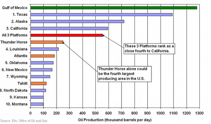
At present (August 2011), there are 27 rigs active in the Deepwater, in water depths ranging from 9,627 ft (Tobago) to one allowed at 922 ft (GC 50). Eight of the rigs are being run for Shell. In total there are about 90 prospects being considered, while 81% of current GOM production of oil and 47% of natural gas comes from the deep waters of the Gulf.
For the three largest fields cited in the plot, Tahiti is believed to hold 4-500 million barrels of oil (mb) started production in 2009 in 4,000 ft of water. Production is nominally some 125 kbd of oil and 70 mcf of natural gas. Atlantis lies under 7,100 ft of water and was set to nominally produce 200 kbd of oil and 180 mcf of natural gas. Thunder Horse lies in 6,050 ft of water, and even with delays due to having to do some re-engineering, is still not performing up to the anticipated 250 kbd of oil and appears to be declining in production at a higher than expected rate. And even when the North field has been added, as Darwinian has noted, production has not been sustained at target levels.
These fields are now generating new projects that lie close to the original discoveries - Thunder Hawk, for example, lies close to Thunder Horse, and is in 5,724 ft of water with total vertical depth (TVD) of the well being 25,885 ft. It is designed for 60 kbd of oil and 70 mcf of natural gas. Further discoveries continue to be made. In June, for example, Exxon announced a discovery in Keathley Canyon, so that even if the original potential is not achieved (and I have not even discussed fields such as Jack, which has been rated at perhaps 500 mboe) there will continue to be sustained production from the Gulf even if it is steadily moving further offshore.
This might be a good point to slip in a little comment about salt domes. When the original Spindletop well was drilled in Texas, it was not recognized at the time that the hill from which the well descended had been formed by a salt dome. Yet once this had been grasped, the slight hills that were the surface feature of these domes became a guiding marker for wildcatting across Texas.
John Bratton has provided a little explanation of the initial history of salt in the Gulf. Simplistically, as the global pull separated North from South America it first created a valley:
The tearing apart of plates does not make an ocean right away. Usually, the big valleys first start to fill as salt deposits form, like those found in the Dead Sea in Israel and Jordan, or the Salton Sea in California. These deposits are called the Louann Salt in the Gulf of Mexico area. As the big crack at the bottom of North America widened, the ocean filled the big valley permanently, new ocean crust began to form, and sediment began washing into the widening hole from the Mississippi. Other rivers and reefs grew along the shore, burying a width of more than 500 km of salt and the edges of the new crust.
Over millions of years, plumes of the light salt began to float up through the heavier sediment that covered it, like the colored liquid in a lava lamp. As the salt made it very close to the surface, sometimes having traveled through more than 10 km of rock and sediment, it pushed up the sea floor above it to form a mound or dome.
The driving force for the movement of the salt lies in the difference in specific gravity between the 2.19 SG of the salt and the typical 2.7 SG of the overlying sediments. As a result, due to the plasticity of the salt, it will flow under the differential pressure and due to its lighter density preferentially deform upwards. (This can be illustrated, for example, at the Wieliczka salt mine in Poland where miners have mined what they thought was virgin salt, only to find old mining equipment buried within the rock.) With time that upward movement pushed through and compresses overlying sediments.
Michel Halbouty has described how the Gulf salt, which can now lie some 30,000 ft below the surface, could then create the traps for oil.
Once the movement of salt begins, the forces of buoyancy are constantly at work, depending on the static weight of the sediments above the salt and on the flanks of the salt core. The main motive force of the uplift of the salt through the sediments is the static weight of these sediments, principally on the flanks of the salt core. The salt stock moves in stages through geologic time, depending on the thickness and the weight of the sediments above and around the salt mass . . .
Cycle after cycle of this procedure took place until the domes gradually pierced their way through the overlying beds to their present positions under the surface of the earth . . . Some of these moved upward rather slowly, so that they could not keep pace with the rapid deposition of sediments and eventually became buried beneath many thousands of feet of overburden. These domes are referred to as "deep-seated," and gas and oil production is generally found in the arched, but unpierced, formations lying over the super-dome area. Other salt stocks, including the one at Spindletop, seem to have developed under conditions that resulted in the salt stocks remaining near the surface throughout their growth history . . . Gas and oil production at these domes is therefore likely to be important in the pierced formations that butt against the sides of the salt mass. It was one of these salt cores that finally settled under an area that is known as Spindletop.
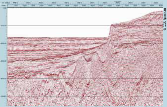
It is difficult to see these deeply buried domes given the current geology of the undersea Gulf surface.
Rather we have to rely on geophysical surveys where the subsea geology is plotted through the return of sound waves, allowing the rocks under the sea to be mapped in three dimensions. Using this technique it is easy to see (even in a simpler 2-D version) the presence of salt domes.
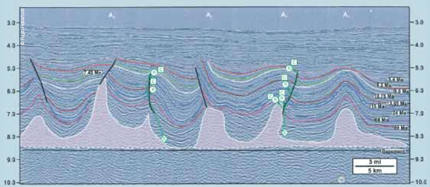
Similar structures extend to the East and are projected to be potential areas for future production closer to Florida. The salt does not just move vertically upwards, but can also flow laterally. However, in earlier times the formations under the salt would not have been distinguishable because of the way that sound waves move through that rock. (The results have been compared with seeing through frosted glass). Thus hydrocarbons in beds below the salt would have been hidden.
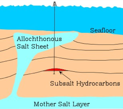
More modern and advanced techniques have allowed formations to be seen both above and below the salt. (Or pre and post salt).
As with the technology to find these deeper reservoirs so increasingly more complex drilling rigs have had to be developed to reach and develop the deposits. This included technology to drill through the salt, first carried out by Diamond Shamrock in 1983, although it was not until the Mahogany field was discovered by Philips Petroleum that commercial subsalt production began. Both Atlantis and Thunder Horse reservoirs lie sub salt.
Not all the equipment works as anticipated and this has been evident, not only with the Deepwater Horizon tragedy last year, but in other rigs and other locations.
Hopefully now, however, the industry has learned the lessons that needed to be learned, and the permitting of new drilling means the new discoveries that continue to be made can be developed without further loss of life.
Contact
- Content: editors at theoildrum dot com
- Tech support: support at theoildrum dot com
License

This work is licensed under a Creative Commons Attribution-Share Alike 3.0 United States License.
The latest Thunder Horse data. As of May it was producing 136,233 barrels per day. They look to be struggling to keep that up.
Ron P.
Looks like every time the flow for both wells gets much above 150k oil per day the water cut jumps up to as much as 25% of flow. Maybe Thunder Horse will never live up to the 250k per day projection for this reason.
Thanks HO for another excellent article.
I have known about salt domes (eg. Dome Petroleum) but I had no idea they are caused by density variation.
Prior to reading these I thought oil came out of a gas station pump, like meat comes from a supermarket.
I sometimes fly rig workers to the helicopter departure airfields, I'm amazed at the consumption of fuel now required to access some oil wells. This is my measure of declining EROEI.
Atlantis, if I am eyeballing your chart up top correctly, is expected to produce around 185,000 barrels per day. It is not really living up to that expectation. In May it produced 61,444 barrels per day. Atlantis has three contracts but only two of them are producing.
Tahiti however is living up to expectations. Production there has been relatively flat for three years now at about 110,000 barrels per day.
Ron P.
For me a little bit undersized platform like Tahiti seems to make economic sense since it could be run at full capacity for quite a long time.
Thanks, Ron.
Dave
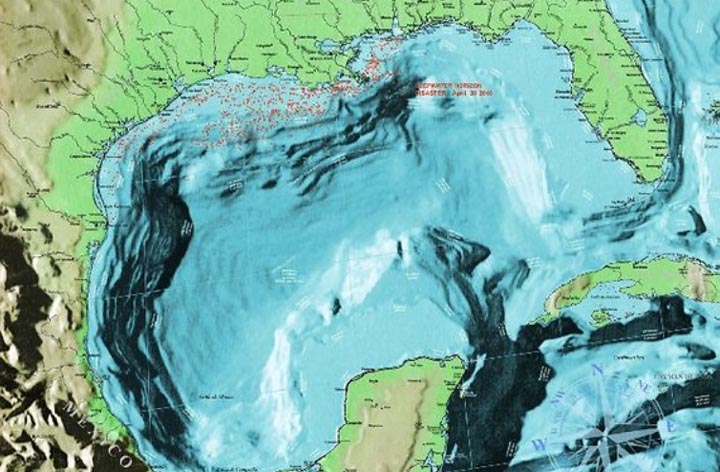
A great topographical map of the Gulf can be found here: The Geography of Offshore Oil
You can zoom in or out on this map and get a good look at the pipeline structure and platform sites. Only a couple of the sites are labeled however.
Ron P.
Thanks Ron. The BOERME still update the GOM infrastructure maps the MMS used to provide, at this page: Gulf of Mexico: Maps and Spatial Data.
Just a simple analysis of the map in your link:
The proliferation of wells off east Texas, Louisiana and Mississippi coasts suggests that the greatest hydrocarbon deposits are off shore where rivers drain a large geographic area (Rio Grande, Mississippi, and Tombigbee/Alabama). Note that before drilling off Florida coast was banned around 1950, the wells there found no appreciable amounts of hydrocarbons. Note also that Macondo well that blew out last year had one of the highest pressures and highest flows of any GOM well. It is close to the mouth of the Mississippi River.
Perhaps Mexico does not have much potential for deepwater hydrocarbons for this reason, IMHO.
Well, you're on to something there, but keep in mind that even in the Pleistocene the mouth of the Mississippi river has flung back and forth across the Shelf from East Texas to Mississippi. Same with ancestral river systems. There are other prolific plays in the pre-Tertiary strata that are not dependent on the fluvial systems at all -- e.g. Cantarell, bay of Campeche, offshore Mexico is one of the biggest oilfields in the world (Upper Cretaceous carbonate breccia). Deep water exploration offshore Mexico is in it's infancy (and it appears that it will remain so for a long time).
BTW, in absolute terms, Macondo not really unusually high pressures; many many wells with higher pressures.
There's a terrific 3D map of production rates from GOM wells at this ca. 2003 MMS page: Production Rates - Deepwater Gulf of Mexico - America's Exploration Frontier. Really illustrates where the big producers are, which is in deeper waters in the Mississippi's fan. One could speculate that shallow wells in other regions might have produced at higher rates when newly opened, but the tech wasn't there to extract it, or get it to shore.
Would be great to have an up-to-date version of this map.
A few nit-picky comments on GOM salt tectonics:
1. Piercement vs. Downbuilding
A new consensus on this old issue emerged in the late 90's, to wit: salt domes don't rise up from great depths "piercing" suprasalt sediments (at least not more that a hundreds to a couple of thousand feet from the mudline). Instead, Barton's 1933 hypothesis of "downbuilding" where salt stays near the seabottom as the surrounding sediments subside due to movement of salt from the source or "mother" layer into the stock/dome. Piercement from great depth is not mechanically possible, and we can observe downbuilding in the recent geology.
2. Buoyancy driving force
Turns out that in the GOM, salt is actually more dense than sediments less than about 5-6000' below the mudline. Once sediment thickness above a salt layer is greater than that, buoyancy exists and salt will flow from high overburden to low overburden areas, feeding existing salt stocks.
There are several ways to initiate salt domes, buoyancy is not one of them - probably the most common mechanism is the GOM is early extension of sedimentary overburden resulting in extensional graben causing local thinning and locally reduced overburden, salt ridges and intervening sediment basins that eventually subside into salt once the average density exceeds salt density.
3. Lateral salt movement / allochthonous salt
In deep water and very dry deserts, salt pumping to surface is not dissolved and spreads out in salt glaciers, sheets, and coalesced canopies - that created large areas of salt overlying younger reservoirs. If deposition is greater than salt supply, you get a dome, if salt supply is greater than deposition, you get an allochthonous body. A thin carapace of hemipelagic mud seems to prevent all the salt flowing out near the deepwater mudline from dissolving.
Although salt and sediment are nearly the same density (neutral at around 5-6000' depth below mudline), the difference in density between salt and seawater is profound (e.g. 2.15-1.10). The impact of this salt-seawater density contrast is for deeply buried weak salt to flow laterally from shallow water areas to deep water areas, high overburden (less water) to low overburden (more water).
4. Seafloor expression of modern salt tectonics
Actually if you look at a modern rendered sea-bottom based on the NOAA multibeam sounding data (e.g. google maps), you will see a profound impact of recent salt tectonics on the bathymetry. For example the Sigsbee Escarpment is an active overthrust of salt over the abyssal plain, numerous salt domes can be observed off SE LA and Central Texas, and many active salt escarpments surrounding actively subsiding salt-withdrawal minibasins off central Louisiana.
But... the sediment around the salt dome slops upward, often trapping oil next to the salt dome. It obviously wasn't laid down in that position so either the salt rose up or the sedimentary rock around the dome sank down. Either way we get the same result.
Salt Dome under Avery Island
Ron P.
Yep, but onlap vs. truncation changes one's predictions of reservoir thickness, timing/growth of faults, etc.
You might be interested in what salt domes can do in an arid erosional landscape:
Upheaval Dome
Not, everyone is convinced salt caused this by itself, i.e. the meteor theory, but the area of Canyonlands contains other features caused by the flow of underground salt.
Some nice images and maps re: salt tectonics here:
http://geology.mines.edu/faculty/btrudgil/research.html
A couple of GOM images as well as great satellite views of active salt glaciers in the desert in Iran.
I understand that salt domes or lateral salt flows are sometimes locations that have hydrocarbons found below them.
I don't understand why this is the case. What caused the hydrocarbons to be concentrated below salt structures?
What's to understand? The oil was generated from source rocks elsewhere and migrated into traps under the cap of the salt domes.
From Geological Sciences 100 page. The chart of where oil has been sourced from is quite interesting as well.
Here's a brief primer on Salt Dome Traps.
Well, there's quite of bit of oil been found and produced from above the salt in the GOM, but most of that's history. The geophysical imaging difficulty of the sub-salt has preserved these accumulations for more recent exploration; basically, even large structures were not mappable without recent technological advances. Some, but not all sub-salt traps have the salt as an impermeable trapping element/lateral seal for hydrocarbons. Other effects of being under allochthonous salt include preserving reservoir quality at greater depths due to reduced temperature gradients and sometimes higher overpressures.
There is nothing about salt that causes hydrocarbons to be created below it. But if there is oil below a salt layer the salt just makes a good cap rock. Most salt layers have no oil below them and most salt domes have no oil in the adjacent tilted sedimentary rock. But it does make a great oil trap when there is oil there.
Ron P.
The erstwhile WebHubbleTelescope produced a 700+ page PDF, "TheOilConundrum" (google it) which describes how oil disperses naturally but is captured by structures including salt domes. After reading it, one understands how the majority of all oil ever born has long dispersed throughout the mantle, and the little oil that ever has been available pooled up for us to find. Had it not been for these structures, the much fewer of us would still be whipping horses.
I find it hard to believe that the world will produce 10 million barrels a day of deepwater oil by 2015. It seems like we would have to have identified this oil, and begun work on the necessary infrastructure. Has anyone looked at what has actually been started? Is Brazil really going to add very much, very quickly?
Gail, if we can't produce that much from deepwater it won't be from a lack of trying. Look on Rigzone and see how many deepwater and ultra deepwater rigs are being built today and look at how many are slated to be built in the future. From someone in the deepwater drilling industry(me) we don't have adequately trained and experienced people at this time for all the rigs being brought online in the next two years. That's the bottle neck,,,,, "people"!
Not having people demonstrates that the economy is trying to add oil supply by using more GDP, labor, and capital than it has for a while. Well we are good at outsourcing. Put an ad out for workers in Asia somewhere.
How much metal are sunk in these structures? Is it labor or sunk metal costs that drive deepwater drilling economics?
It's a huge amount of metal to build an ultra-deepwater rig, but when you talk about labor it's not just workers. You have to find or train skilled workers that can leave home for 14 to 28 days and I have worked with people that stay for months without a day off. It's finding a different breed or person that already has a foundation and then training him right to build on that strong foundation. Rigs can be built faster than we can safely and efficiently man them at this point. It's not like America and other countries doesn't have warm bodies, it's what in the heart and mind that's the key.
Deep Water rig workers of all stripes and experienced service techs don't grow on trees and there's no school that teaches the skill sets needed it's mostly OJT. It's going to be fun to see how this plays out. I love it.
Oct - Something of a two phase answer. On the exploration end it's all labor, rental charges and fuel. In a sense the sunk capital and steel used to build the drilling infrastructure doesn't come into to play. When you amortize it over the life of the equipment the number is still rather small compared to the overall expense. Much of the labor expense is hidden inside the rentals. A DW rig may have a day rate of $600,000 with labor costs included in that amount. Nearly all the other rental costs include the high paid techs that come with the package. Likewise materials, such as drilling mud, have a labor cost attached. So a drilling op may have a "burn rate" of $1,000,000 per day: rentals might be around $800,000/day, materials around $100,000+/day and fuel somewhat under $100,000/day. By contrast during a DW driling slump the burn rate could drop from $1 million to less than $600,000. Same amount of materials used but those rental rates drop low.
The second phase includes the infrastructure buildout and development well drilling. I can't recall any numbers for the complete DW facility package but I bet someone will toss one out shortly. Obviously a lot more metal is used in this effort. But if you break it down into material costs vs. labor/profit margin, the cost/volume of steel, etc is probably smaller than most folks would guess. The costs related to drilling the devlopment wells mirror the exploration phase.
This is why the slowdown in DW hits the non-oil company oil patch very hard. The huge loss of revenue is felt by the contractor companies and their labor pool. The ExxonMobil's don't lose money so much per se. They just have a reduced opportunity to make money. But the service industry losses $billions in cash flow and paychecks.
Might all these 'little' amounts start to add up? 5mbpd from deep sea, 1-2mbpd from oil sands, some economic contraction, maybe a dash of hope from algae oil, and perhaps maybe no 'hard' oil crunch by 2015?
I think our other worldwide economic problems may push back the "hard oil crunch". Look at what happened to oil consumption in America after the recession. As long as the economy doesn't tank to the point where drilling rigs start cold stacking, new builds loose funding and theres mass layoffs of our drilling workforce. It could get ugly, I can't wait to see what happens.
You have to overcome the global average decline rate, whatever that is. IEA seemed to suggest 4.35% based on the bottom-up analysis in the 2008 WEO, so figure ca. 3.4 mb/d lost per year = 13.6 mb/d gone between now and 2015. And that rate will accelerate over time, as more production comes from UDW, with its attendant high decline rates. This is likely why we're on an extended plateau; no spare capacity means prices go up, which is good for producers, they can attempt to add supply, and there's no end of fresh demand from developing nations; but the declines are so steep all they can do is run in place, in essence.
Also IEA seem to think C+C peaked 5 years ago, so better bring on that algae. How's cellulosic doing lately? Last year they produced something like 50 boe, despite huge mandates/incentives/subsidies in the US.
Analysis: Cellulosic ethanol industry struggles to take off | Reuters
When are we (the gov) going to learn that mandating technologies produces nothing but a high state of pizzedoffedness?
Heading Out,
You might want to update that chart of relative oil production: N. Dakota is now well ahead of all three platforms and Louisiana.
Yes, N. Dakota averaged 361,000 bopd in May 2011.