Hurricane Dean Update: Here's What We Know about Mexico's Oil and Gas Infrastructure and Supply
Posted by Prof. Goose on August 19, 2007 - 8:30pm
UPDATE, NEW POST UP TOP AS OF 1:20 AM EDT, 8/21
We know that many of the models have Dean going into the Bay of Campeche. But what does that mean for supply and production?
Well, if the current forecast holds we could be talking about 2.5 million barrels per day of supply capacity being shut in for a while, and some of that for an extended amount of time. Can that matter when the US consumes about 21 million barrels per day (and the world consumes 85 mbpd)? Yes.
Especially when there isn't "slack" supply to be brought to market. That is what "peak oil" is about.
The markets aren't reacting yet. Do they know something we don't know? Maybe.
But what do we actually know about Mexico and its supply and infrastructure?
Under the fold (click "there's more" below), I am going to try to bring together some of our information we have gleaned to this point. I also encourage you to deliver news tips, forecasts, insights, and other links in the comment thread below.
UPDATE: PEMEX is shutting down ~140 rigs and moving 13,000+ workers on land. Cantarell + Ku-Maloob-Zaap account for 66% of the total oil production of PEMEX in June 2007. Cantarell alone is 47%.
To begin, we have some recent history with this kind of track. Hurricane Emily followed a track similar to the modeled path, but she was a weak Cat4 when she hit the Yucatan in 2005. Dean is forecast to be a mid-range Cat5, which means, with relative flatness of the Yucatan, he could reemerge in the Bay of Campeche as a Cat1 or Cat2.
***
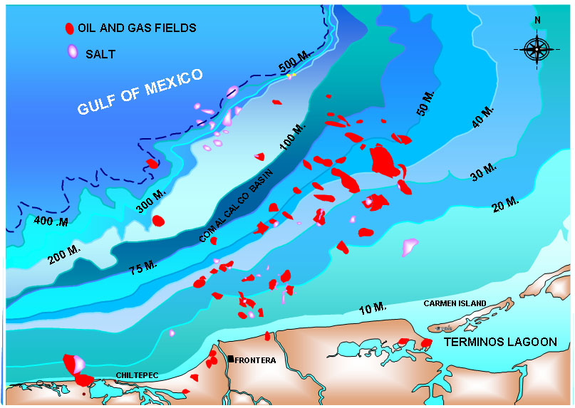
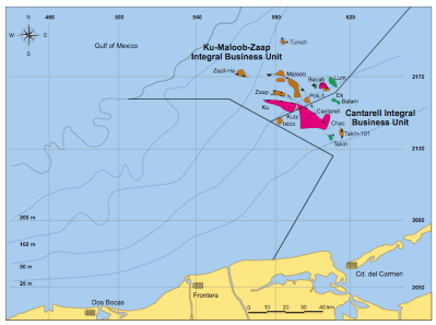
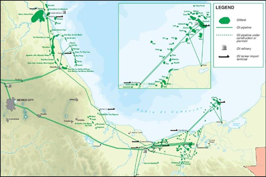
What is the area we're worrying about? Cantarell and KMZ, as said above, PEMEX is shutting down ~140 rigs and moving 13,000+ workers on land. Cantarell + Ku-Maloob-Zaap account for 66% of the total oil production of PEMEX in June 2007. Cantarell alone is 47% of the total....and here's the best pic we have (right click and view image to see full size):
***
The United States imported approximately 620,000,000 barrels from Mexico last year. (http://tonto.eia.doe.gov/dnav/pet/hist/mttimusmx1m.htm)
More on importers (Mexico is the 2nd ranked importer (at 1.5 MBPD) to the US behind Canada in 2007, then comes Saudi Arabia): http://www.eia.doe.gov/pub/oil_gas/petroleum/data_publications/company_l...
The IEA on Mexico: http://www.iea.org/Textbase/country/m_country.asp?COUNTRY_CODE=MX
Google maps of the Bay of Campeche: http://maps.google.com/maps?ie=UTF8&om=1&z=7&ll=19.849394,-94.163818&spn...
***
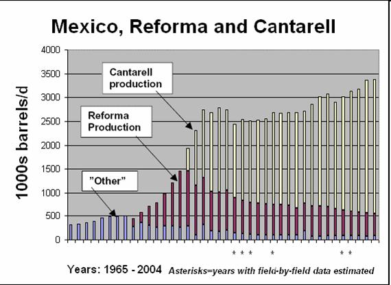
Khebab posted "An Update on Mexico's Oil Production--The Rapid Collapse of Cantarell by the Numbers"
Last year, I expressed my concerns about the eventual impact of a rapid collapse of Cantarell on Mexico's oil production (story here). The last production numbers from PEMEX seems to confirm the rapid decline of Cantarell as well as the inability of the Mexican to rapidly bring new production online. The Wall Street Journal (thanks to Jerôme) published an article on Cantarell last week:
The virtual collapse at Cantarell -- the world's second-biggest oilfield in terms of output at the start of last year -- is unfolding much faster than projections from Mexico's state-run oil giant Petroleos Mexicanos, or Pemex. Cantarell's daily output fell to 1.5 million barrels in December compared to 1.99 million barrels in January, according to figures from the Mexican Energy Ministry.
***
Euan Mearns put some flesh on the bones of Mexican oil production here (discusses the KMZ area very nicely and has a couple of nice maps too.)
Following on from Khebab's posts (Jan 2007 and July 2006) I wanted to put some production geology flesh on the bones of Mexican oil production. The main points I want to make are:
1. Forecast production decline of 14% per annum in Cantarell sounds alarming but it is in fact the result of planned reservoir management.
2. The forecast decline of Cantarell is due in part to the diversion of nitrogen injection from Cantarell to the neighbouring Ku-Maloob-Zaap (KMZ) complex of fields. Production at KMZ is forecast to rise to around 800 MBD and this will partly offset production falls at Cantarell.
3. Cantarell / Mexican production is predominantly heavy crude, and it is postulated that any production declines in Mexico may be met by additoinal production of Saudi Arabian heavy crude forward to 2012.
4. Notwithstanding point 3, Mexican oil production decline means that 4 out of 5 major OECD producers are now in decline (Norway, UK, USA and Mexico), leaving only Canada with growing production and this presents the OECD with a growing problem of energy security.
5. The Hubbert Linearisation (HL) for Mexico reflects reservoir management (gas lift and nitrogen injection) and new field developments but the interpretation remains equivocal. A brief description is given of why Pemex have used gas lift and nitrogen injection to boost production at Cantarell.
***
Luis de Souza put together this analysis of world oil exports for Mexico
Mexico is here assessed to be capable of producing a total of 50 Gb to 2075, giving a midpoint of depletion in 1999, some fourteen years after what appears to be a premature actual peak in 1985. Production now stands at about 3.2 Mb/d, being subject to a fairly high depletion rate of 5% a year.
Mexico seems to have peaked only in 2004, but the future decline rate is maintained.
***
Ace also does some work on Mexico on his Updated World Oil Forecast.
***
All TOD Work on Cantarell and Mexico
http://www.theoildrum.com/tag/cantarell
http://www.theoildrum.com/tag/mexico
***
Mexican Oil reserves:
http://www.ruf.rice.edu/~leeman/MexOilReserves.gif
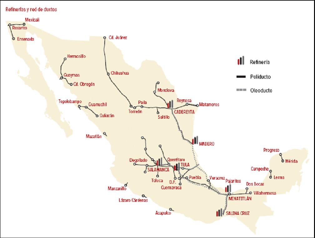
Mexican refineries:
http://www2.nrcan.gc.ca/es/es/NA-enrgpic2006/rpImages/5-04-e.gif
***
Some PEMEX background:
http://en.wikipedia.org/wiki/Pemex
http://en.wikipedia.org/wiki/Cantarell_Field
Here's a list of refineries:
* Minatitlan Refinery (Pemex) 170,000 bpd
* Cadereyta Refinery (Pemex) 292,000 bpd
* Tula Refinery (Pemex) 320,000 bpd
* Salamanca Refinery (Pemex) 236,000 bpd
* Ciudad Madero Refinery (Pemex) 190,000 bpd
* Salina Cruz Refinery (Pemex) 320,000 bpd
***
More from PEMEX on KMZ: http://www.pemex.com/files/content/ACFWVNY7kO2v.pdf
***
Almost Total Cantarell Evacuation
Mexico clears oil rigs as hurricane nears
Might order total well closureMexican state oil company Pemex on Sunday evacuated thousands of oil workers from the Gulf of Mexico and warned it might close up to 2.2m barrels a day of crude oil production as the powerful hurricane approached.
Pemex said it was evacuating 13,360 workers – most of its workforce in the area - and that it might order the ”total closure of the oil wells” in the Cantarell oil field and other fields.
http://www.ft.com/cms/s/0/96593284-4e46-11dc-85e7-0000779fd2ac.html
***
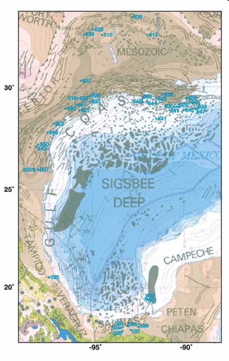
This is from the EIA Hurricane analysis for 2007, showing historical production of oil and gas from the Outer Continental Shelf of the Gulf of Mexico.

Oil production seems to be about 1.4 million BPD; natural gas appears to be about 7.5 billion cu. ft. per day.
***
And then some charts and maps and such:

Hurricane Dean Update: Here's What We Know about Mexico's Oil and Gas Infrastructure and Supply
PDF version
58 comments
Hurricane Dean Update: Here's What We Know about Mexico's Oil and Gas Infrastructure and Supply
PDF version
58 comments
Contact
- Content: editors at theoildrum dot com
- Tech support: support at theoildrum dot com
License

This work is licensed under a Creative Commons Attribution-Share Alike 3.0 United States License.
http://science.reddit.com/info/2gqzj/comments
http://digg.com/business_finance/Dean_Update_What_We_Know_about_Mexico_s...
if you are so inclined...
What I would welcome right now is information on:
a) how much of Mexico's total production is affected
b) what's the design standards of those rigs in Campeche, and
c) thoughts on how long will this go (which is Chuck Watson's bailiwick...and right now, his initial estimate has a chance of a couple of months off line with the current models (when I wrote this, it was a Cat2 coming into Campeche, now it's projected to be a Cat1) and estimates--more on that tomorrow)
any other detailed maps of Cantarell and Campeche are welcome, but please do continue linking to maps (esp. of Cantarell/Jack/Yucatan), oil maps, NG maps, LNG stations, refinery maps, pipeline maps, shipping lanes, rig maps, news stories, weather, track predictions, strategic resources, and all that other stuff in this comment thread.
Not to detract from what really is a heckuva nasty weather event that will cause hurt to many, but the oil market is still not having it. Dean doesn't scare them any more (Brent: 68.50)
http://www.bloomberg.com/energy/
I'll stick my neck out here and say those traders know something we don't. Perhaps Dean is not expected to be able to get it up after tangling with the Yucatan. At least not enough to damage the oil infrastructure.
Tokyo equities are surging so it's not renewed mortgage panic taking down oil.
You may be completely right A...and it makes sense that landfall would kick Dean in the weather nuts, but that is REALLY flat in the Yucatan.
Hey, if it doesn't do anything, that's ok...we have to be prepared to cover it...it's what we do!
I am still guessing that they're off line for quite a while. Who knows how long though...
It doesn't matter how flat the land is. The hurricane draws its power from warm water. If its traveling over 250 km of land, no matter if its only 1mm above sea level, it will lose strength. As I said on some of the other threads, very little damage has occurred to those oil producing regions when a hurricane hits the Yucatan first. This will be no exception.
Exactly party guy, the storm will be shell of itself after the Yucatan, and cantrell is on the south side of the track (weak side).
Well, if the current forecast holds we are likely talking about around a million barrels per day of supply capacity being shut in for some extended amount of time.
Doubtful, all clear will be called in a couple days and everything will be back up and running. Let's not overreact.
I would like to think that's true.
But if the storm comes over as a weak Cat 2 and hits these rigs...well, all I am saying is that it's hitting an area that might not be prepared for it. We don't know...and that's why I am asking the questions that I am. Find me confirmation that those rigs are moored so that they can stand a Cat 2...cause I sure can't...especially since my Spanish sucks so badly.
Hey, I'm just putting together resources...I don't predict the weather! :)
From weather nerd central (which of course, means little):
http://www.easternuswx.com/bb/index.php?showtopic=140291&st=20
Hello Prof. Goose,
Exactly right! Given the proper conditions, a hurricane can traverse the Yucatan and not loose any intensity:
http://en.wikipedia.org/wiki/Hurricane_Roxanne
--------------------------------
During the afternoon of the 10th, as Roxanne became a hurricane and a well-developed eye formed. Shortly after Roxanne reached hurricane strength, it rapidly intensified to Category 3 strength (the first time that had happened in the western Caribbean Sea since the 1961 season when Hurricane Hattie took a very similar turn and intensification cycle.[1]). Roxanne made landfall near peak intensity just north of Tulum, a small town near Cozumel, Mexico, with sustained winds near 115 mph. Roxanne did not drop hurricane strength over land, despite the hurricane being inland for almost a full day and a half.
----------------------------------
So Dean, if it can remain a big CAT 4 or 5 before it crosses the Yucatan: could presoak the land sufficiently that when it finally crosses it--it might not lose much intensity, size , or strength.
Bob Shaw in Phx,Az Are Humans Smarter than Yeast?
"Given the proper conditions, a hurricane can traverse the Yucatan and not loose any intensity"
The Wikipedia text is poorly worded. Roxanne remained a hurricane, but it weakened from Cat 3 to Cat 1.
http://www.nhc.noaa.gov/1995roxanne.html
On top of that, it is very well established that 1) warm water powers hurricanes - the deeper the better, and 2) hurricanes rarely remain at Cat5 for long, even over deep warm water. There's no way that Dean will transverse the Yucatan and remain a Cat5, or even Cat4.
Look at what happened to Emily when it crossed a much shorter section of the Yucatan - Cat4 to Cat1.
http://en.wikipedia.org/wiki/Hurricane_Emily_%282005%29
Hello PeakVT,
Thxs for responding. You are probably right, but the NOAA document on CAT 5 Hurricane Andrew suggests that a hurricane can temporarily intensify over land even an hour after landfall given the right conditions:
http://www.nhc.noaa.gov/1992andrew.html
----------------------------------------
Andrew weakened when it passed over the western portion of the Great Bahama Bank and the pressure rose to 941 mb. However, the hurricane rapidly reintensified during the last few hours preceding landfall when it moved over the Straits of Florida. During that period, radar, aircraft and satellite data showed a decreasing eye diameter and strengthening "eyewall" convection. Aircraft and inland surface data Fig. 4 [121K GIF]) suggest that the deepening trend continued up to and slightly inland of the coast. For example, the eye temperature measured by the reconnaissance aircraft was at least 1-2C warmer at 1010 UTC (an hour after the eye made landfall) than it was in the last "fix" about 15 n mi offshore at 0804 UTC. These measurements suggest that the convection in the eyewall, and the associated vertical circulation in the eye and eyewall, became more vigorous as the storm moved onshore. The radar data indicated that the convection in the northern eyewall became enhanced with some strong convective elements rotating around the eyewall in a counter-clockwise fashion as the storm made landfall. Numerical models suggest that some enhancement of convection can occur at landfall due to increased boundary-layer convergence in the eyewall region. That situation appeared to have occurred in Andrew. The enhanced convection in the north eyewall probably resulted in strong subsidence in the eye on the inside edge of the north eyewall. This likely contributed to a displacement of the lowest surface pressure to the north of the geometric center of the "radar eye" (cf., Fig. 4 and 6 [107K JPEG]). It is estimated that the central pressure was 922 mb at landfall near Homestead AFB, Florida at 0905 UTC (5:05 A.M. EDT) 24 August (Fig. 4).
Andrew moved nearly due westward when over land and crossed the extreme southern portion of the Florida peninsula in about four hours. Although the hurricane weakened about one category on the Saffir/Simpson Hurricane Scale during the transit over land, and the pressure rose to about 950 mb, Andrew was still a major hurricane when its eyewall passed over the extreme southwestern Florida coast.
--------------------------
Recall that Andrew was a small and tight CAT 5: so maybe porportionately the scale of Andrew/South Florida might be equivalent to a big area CAT 5 Dean/Yucatan. Will Dean continue to intensify two hours after making landfall? It might be only possible to compare this after Dean makes it Yucatan traverse; a post-mortem analysis much later like what was done for Andrew.
From the stormtrack projection it appears that Dean will be traversing the Yucatan in daylight or during the heating cycle. If there is sufficent warm rainwater on land plus lots more moist heat streaming into Dean from the outlying feeder bands-- it may not lose that much strength over land and/or nearly instantly regenerate in intensity as soon as the eye gets offshore. Thus, I speculate the Cat 2/3 boundary at offshore Cantarell/KMZ does not seem that far-fetched IMO.
Of course, I would gladly defer to expert opinion from NOAA.
Bob Shaw in Phx,Az Are Humans Smarter than Yeast?
Andrew passed over what, 50km of land? Dean might have to cross 250km of land. Dont you think its going to affect it?
Remember that Katrina and Rita were only category 3 hurrianes when they hit land. Dean is forecasted to fall to category 2 and then restrengthen to category 3 before hitting the mainland.
From the looks of things, there's quite a bit of oil related infrastructure where the storm is forecasted to make land. This could still be a terribly devastating event.
I did inhale.
i dunno, can we be certain that it will hit yucatan ? and why is pemex evacuating ?
The history of storms would seem to indicate that they are supposed to loose strength over land, but then how would you explain Erin -- Which gained some strength yesterday and tried to reform an eye?
I don't think we know everything there is to know about weather quite yet.
I said several days ago that in the event it missed the good ole US of A and hit Canterell directly, there would be a big celebration, mostly because us americans don't have a clue where oil comes from. The neocons probably think Jesus provides it. Wait until they find out Jesus does provide it, if you sub the J for an H. I'll be dumping my oil tomorrow for a small gain/loss, but only because the Oct goes FM on Wednesday and it is usually the worse month to hold barrels.
Pemex, as stated above, is planning to perhaps shut in 2 mmbbl. I know those barrels don't go to Jamaica, so I wouldn't go short oil anytime soon despite my worry above.
If it does shut down 2 million bpd, it will only be for a day or two. The hurricane will likely lose most of its strength crossing the Yucatan, and quickly move back into land inside a day.
Well, according to the PEMEX press release, they already started evacuating the facilities. The storm is 3 days away. Add 3 days to the other side plus 1 for the storm and thats a week.
Plus, your assuming everything will be just fine, and I'm assuming they are evacuating because things tend to break during hurricanes. Why else evacuate?
Lastly, Cantarell and Kukucachu, or whatever it's called, are a way off shore. Far enough for the eye to reform.
Maybe you are right on the end result, but you're definitely way off on the 4mmbl. Something always breaks, even when the weather is fine.
Yes, and Gonu was supposed to take 100 million barrels total of the market. And that is exactly what happened, right?
"supposed to"...that's a smidge strong don't you think?
Excellent summary, Prof.
I found an older (2003) poster of Pemex assets here (~3Mb):
http://downloads.pennnet.com/os/posters/2003_m14.pdf
I'm more worried of what Dean's impact will be after it gets past Campeche and then starts building steam again in those warm waters...could impact the refineries and infrastructure on the other side of the Gulf such as those at Ciudad Madero.
Are you a peak oiler? www.cafepress.com/crashdummy
Hello TODers,
From the very bottom of the last Dean keythread, plus some additional speculation {Prof. Goose, feel free to delete if this is seen as needless duplication}:
Hello Asebius,
Dean hitting Mexico, and not affecting oil prices could be a big mistake on the traders' assumptions. Let me explain my feeble reasonings:
1. Assume Dean hits somewhere between Veracruz and Tampico after crossing the Yucatan.
2. The Liebig Minimum in the Mexican FF-infrastructure might be the electric powerlines and pipelines as they cover the greatest distance and are most exposed to high winds, flash-floods, and landslide events.
3. High tension towers twisted like preztels, or washed down a hillside will take a long time to repair or replace even if you can secure the steel materials. There will be lots of washed out roads and bridges in Mexico if Dean is a severe rainfall event. Hell, a lot of their roads are poorly maintained already. Buses going off cliffs regularly, and that sort of thing! =(
4. Much of the same phenomena applies to pipelines if a significant number of washouts occurs. You can't start refilling a pipeline until all breaks are repaired and electrical juice is resupplied to the numerous pumping stations along the pipeline route.
5. I have no idea how close to sea-level the ports and refineries are in Eastern Mexico, but obviously a storm surge would screw things up for awhile, but it may not be a disaster [just a real pain in the ass]. A worse event would be a landslide or huge flash-flood really re-arranging the refinery equipment and/or causing a big fire. Or totally disabling a powergen plant by putting 10 feet of mud inside a turbine.
6. I have no knowledge of Mexico's Grid System, but if the Yucatan gets splayed plus the eastern coastline gets whipsawed, can the other parts of Mexico shift enough power to these areas to help power what infrastructure they have until it all gets repaired?
7. For example, if the offshore oilfield platforms [Cantarell, KMZ] ride through the hurricane relatively undamaged, but you cannot generate the power to gasify the oilfields-- not much is going to come up out of those production platforms.
8. Recall from much earlier postings of mine than Mexico is the acknowledged world class leader in deforestation and desertification. So a huge rainfall event could be quite destructive, and high winds and any storm surge would just be further cascading blowback events.
9. Mexico is an importer of gasoline. Pretty difficult to repair infrastructure if you can't import sufficient fuel to run trucks, bulldozers, cranes, etc, because the off-loading ports and pumps are disabled.
In short: Mexico is relying on very long, very thin spiderweb strands. It might also be seen as a golden opportunity for an explosive attack, or your normal run of the mill stealing of copper and other goodies. Who knows?
Bob Shaw in Phx,Az Are Humans Smarter than Yeast?
Europe was one big forest before the people came and chopped it down. The Mediterranean was full of dense forest (e.g. cedars of Lebanon) before the people came and chopped it down. They're finding evidence of large-scale smelting in the Iraqi desert. You can't smelt without LOTS of cheap wood. This suggests that Iraq had plenty of cheap wood, before people arrived.
As for Mexico, who do we blame? The deforestation grew to a fever pitch only long after the Spanish conquest. If it's worse than America right now, you can imagine that this is so because America can afford to "offshore" its deforestation, if only for a little while...
Yes, Prof. Goose, this is an excellent summary.
Thank you.
The 11PM update is now up. The latest forecast show the eye passing about 50 miles from Cantarell as a cat. 1 with peak wind speeds of 92 mph. The wind charts show that the facilities on shore ought to see significantly lower wind speeds:
From where did this update originate?
It is essentially the NHC forecast in a form that can be displayed on Google Earth. Khebab has the links in his blog, or you can just go to www.guiweather.com and find them there. The location of Cantarell is from a link that Khebab sent out.
Actually I realized that I had left all of the different models turned on which confuses things. The red/blue line is the actual forecast.
The circular blobs of varying colors are the predicted wind patterns. I *believe* the outermost ring are TD force winds, the next one in is TS force winds. In some of these, they show a 3rd ring with hurricane force winds. I haven't found the actual legend to verify this, but the kml source implies this.
In another 30 minutes or so, the 8AM update will be up, and I will post a refresh of the image.
The problem with any forecast with a hurricane is they are just too darn big and powerful with so many factors affecting them that they are very difficult to predict.
I have my doubts as to any forecast before the storm reenters the Gulf. Its still not impossible for Hurricane Dean to hook north and come ashore on the US Gulf Coast, its not even out of the Carribean yet.
It seems to me that we are willing to assume the worst always on The Oil Drum. Bob Ebersole
I am not assuming the worst...it is called preparation.
I rather hope that the damn thing dies before it hits the Yucatan and that people and their lives are spared.
As I said yesterday, the human toll of this event saddens me greatly.
It is impossible to hook north. Look at the winds aloft. Nothing is blowing north or east within a 1000 miles. Nothing.
Yep, jteehan's right. There's nothing out there to steer this thing North...usually there's a high pressure in the SE US to make that happen, but there's nothing there!
"it is impossible to hook north".........yes that would be a slice.
Hello TODers,
Please read my speculative post upstream in this thread first.
The major problem with hurricanes crossing the Yucatan, then restrengthing across the GoM, then slamming into Eastern or Southeastern Mexico is that the hurricanes tend to drop tremendous amounts of rainfall as they are prone to dilly-dally around after hitting the high mountain ranges in Mexico.
The weather airflow is disrupted by the many diverging wind currents sweeping over the central mountains; it may take time for the jetstreams to sweep the tremendous thunderclouds clear of the mountains, then out to sea, or up into the US heartland. This downpouring weather effect combined with deforestation and desertification, plus poorly maintained Mexican infrastructure is what would cause the greatest damage and delay repairs to the FF-spiderwebs.
http://en.wikipedia.org/wiki/Category:Hurricanes_in_Campeche
EDIT: http://www.alertnet.org/thenews/newsdesk/N19350170.htm
----------------------------
The bulk of Mexico's crude oil exports are shipped through the Mexican Gulf from Dos Bocas, Cayo Arcas and Pajaritos ports. The ports are still open, Mexico's government said.
The last storm to seriously disrupt Mexico's oil industry was in July 2005, when Pemex had to evacuate thousands of rig workers, temporarily cut off oil production from dozens of rigs and briefly halted shipments due to Hurricane Emily.
-------------------------
Maybe we need to see where these shipping ports are located, and how many miles of power-towers, pumping stations, and pipelines are required to keep them up and running. How many riverbeds for the pipelines, and/or mountain ranges for the high tension gridtowers? Underground electrical lines?
Bob Shaw in Phx,Az Are Humans Smarter than Yeast?
Hello TODers,
Found this link on the loading ports with photos:
http://www.tomasruiz.com.mx/porti.htm
My initial hunch is that as long as electrical juice is available to run the pumps--no real problems with raw crude exports to the US.
EDIT: So maybe the real problem is to see how much possible damage might happen to the infrastructure that Mexico itself is highly reliant upon for their societal needs.
Bob Shaw in Phx,Az Are Humans Smarter than Yeast?
http://www.pemex.gob.mx/index.cfm?action=mapa
A very cool map...forwarded from an industry insider. (it's Flash, so I couldn't paste it.)
Hi PG,
Thanks for the update and the info on Mexico!
The update in the chart below shows that Dean is predicted to head for Cantarell and KMZ.
http://www.nhc.noaa.gov/refresh/graphics_at4+shtml/024525.shtml?5day#con...
and evacuation has started
"Mexico's Pemex oil company started to evacuate 13,360 workers from its Gulf rigs ahead of Dean's arrival there."
http://www.thepeninsulaqatar.com/Display_news.asp?section=World_News&sub...
Hello ACE,
Thxs for the update! So from eyeballing the chart, and guessing at the sustained forward speed of Dean: it appears it might traverse the Yucatan, at the narrowest part in under 12 hours. If Dean can grow even larger than it is now, plus it can sufficiently presoak the Yucatan with the feeder bands prior to the quick traverse [Roxanne style, see Wikilink upthread by me] it could hit Cantarell and KMZ at CAT 3, 4 or gulp, CAT 5. Hope, I am wrong!
Bob Shaw in Phx,Az Are Humans Smarter than Yeast?
Hello TODers,
I have posted on this before in TOD:
One more dire point to consider: the latest Dean stormtrack projection would not have to swing very far south for flooding rains to hit Mexico City, then:
http://www.bloomberg.com/apps/news?pid=20601086&sid=a4otVGXRyL04&refer=l...
--------------------
Sewage Spill Looms as Mexico City Mayor, President Cast Blame
``We may witness the worst flooding in modern history in Mexico City,'' President Felipe Calderon said in a speech last month that Mayor Marcelo Ebrard refused to attend.
July and August are the crucial months, when most of the area's 76 centimeters (30 inches) of annual rainfall occurs. Calderon warned that the city is on the brink of ``catastrophe.''
A failure in a single section of the main drainage canal could flood 210 square kilometers (80 square miles) and require the evacuation of 4 million people, according to an Inter- American Development Bank report.
``The question is not whether a catastrophe is going to happen, but when is it going to happen again,'' said Exequiel Ezcurra, former head of Mexico's National Institute of Ecology.
-----------------------------
If you read about the amazing rainfall amounts that have occured in the past hurricanes in various parts of Mexico--I betcha Mexico is becoming increasingly worried about Dean.
Bob Shaw in Phx,Az Are Humans Smarter than Yeast?
Hi Bob,
According to Monday 5 AM update
http://www.nhc.noaa.gov/text/refresh/MIATCPAT4+shtml/200838.shtml
"MAXIMUM SUSTAINED WINDS ARE NEAR 150 MPH...240 KM/HR...WITH HIGHER GUSTS. DEAN IS AN EXTREMELY DANGEROUS CATEGORY FOUR HURRICANE ON THE SAFFIR-SIMPSON SCALE...AND HAS THE POTENTIAL TO REACH CATEGORY FIVE STRENGTH WITHIN THE NEXT 24 HOURS." (CAT 5 means winds>155 MPH)
This means that Dean would hit the east coast of the Yucatan probably as a CAT 5, weaken and be somewhere between CAT 1 and CAT 3 in the Bay of Campeche. This could remove up to 2mbd oil supply from Cantarell and KMZ for at least one week.
Dumb question. There is finite amount of oil in Cantarell that is depleting rapidly. So if Cantarell is shut down for say a month, she'll just produce oil for an extra month down the road. What difference does it make?
Hello Robert2734,
It depends on how damaged the Mexican offshore platforms and the supporting infrastructure gets whacked by Dean. No delays, or very minor delays: it will follow your example.
Something worse, say maybe Mexico's version of the USA's KATRINA/RITA 2005 twofer, then you could really see Mexico's exports to the USA shrink and/or Mexico itself having big fuel shortages.
Worst scenario of all: Mexico gets badly hit by Dean, then the hurricane bounces off the Mexican Sierra, then reforms again in the GoM to nail the USA offshore rigs. Yikes!
Bob Shaw in Phx,Az Are Humans Smarter than Yeast?
Thanks Toto. Given that Texas is evacuating their offshore oil workers, why are we reading something into the fact Mexico is evacuating theirs? It just means an abundance of caution. Or are we just trying to figure out how much oil production is being removed from the market by the evacuations.
I was reading up on hurricanes being bored and 2am and nothing better to do. Evacuating Galveston through Houston was a nightmare during Rita and many Galvestonians say they rather stay put than die in their cars. Why do we blame Katrina victims for staying put? Most of the stayputters didn't have a choice in the first place. I hope Oilman whatshisname is ok. He probably knows exactly what to do in a hurricane, unlike me. It's like earthquakes for Californians.
Because in 1990 Hurricane Diana dropped by 10 knots/20% from 55 mph when it hit the Yucatan to 45 knots when it left it two days later.
http://weather.unisys.com/hurricane/atlantic/1990/index.html
A Cat 4 dropping 20% leaves it a piece of weather that could do long term damage to the Cantarell complex.
Ian Whitchurch
Long term damage to the cantarell complex? It's like shooting bullets into an empty gas tank. What difference does it make. There ain't no oil left in cantarell no matter how much it produced in the past. Why do you think we are building a fifteen hundred mile fence?
Robert,
Decline does not mean no production. North Texas is in decline, and has been for a good long time, but it is still producing meaningful amounts of oil.
Likewise, Cantarell, although certainly in decline, will still produce meaningful amounts of oil. A 1.4 mmbd field that declines by 80% still produces an important amount of oil.
Everyone else,
Janet in 1955 tells the tale of the tape.
http://weather.unisys.com/hurricane/atlantic/1955/JANET/track.dat
16 13.90 -72.90 09/25/12Z 115 993 HURRICANE-4
17 14.30 -74.30 09/25/18Z 115 988 HURRICANE-4
18 14.70 -75.50 09/26/00Z 120 - HURRICANE-4
19 14.80 -76.30 09/26/06Z 120 - HURRICANE-4
20 15.00 -77.10 09/26/12Z 125 970 HURRICANE-4
21 15.40 -78.00 09/26/18Z 125 - HURRICANE-4
22 15.90 -78.90 09/27/00Z 130 - HURRICANE-4
23 16.50 -80.20 09/27/06Z 135 914 HURRICANE-4
24 17.00 -82.00 09/27/12Z 140 938 HURRICANE-5
25 17.50 -84.10 09/27/18Z 145 - HURRICANE-5
26 18.00 -86.10 09/28/00Z 150 - HURRICANE-5
27 18.50 -88.20 09/28/06Z 130 - HURRICANE-4
28 19.00 -90.20 09/28/12Z 95 950 HURRICANE-2
29 19.30 -91.90 09/28/18Z 90 - HURRICANE-2
30 19.50 -93.10 09/29/00Z 90 - HURRICANE-2
31 19.70 -94.20 09/29/06Z 95 - HURRICANE-2
Cat 4, strengthens to 5 as it hits Yucatan, slows down by 60 knots going over Yucatan, and Cantarell still eats a Cat 2.
Now, can Cantarell absorb a cat 2 ? Dunno. If the future is clear, Janet, then we'll all find out.
Ian Whitchurch
Interesting. Hilda, also in 1955, hardly slowed at all.
http://weather.unisys.com/hurricane/atlantic/1955/HILDA/track.dat
21 19.10 -84.40 09/15/18Z 100 - HURRICANE-3
22 19.20 -85.40 09/16/00Z 100 963 HURRICANE-3
23 19.40 -86.40 09/16/06Z 95 - HURRICANE-2
24 19.60 -87.40 09/16/12Z 95 - HURRICANE-2
25 19.90 -88.40 09/16/18Z 90 - HURRICANE-2
26 20.20 -89.30 09/17/00Z 85 - HURRICANE-2
27 20.60 -90.20 09/17/06Z 85 - HURRICANE-2
28 20.90 -91.00 09/17/12Z 90 - HURRICANE-2
29 21.10 -92.00 09/17/18Z 90 - HURRICANE-2
30 21.30 -92.90 09/18/00Z 95 - HURRICANE-2
31 21.40 -93.60 09/18/06Z 100 - HURRICANE-3
If there is serious damage in the Bay of Campeche which shuts in extraction of 1-2 MMbbl/d for several months then OPEC could raise quotas and still keep prices around $70 bbl. That is if KSA can actually increase output. Failure to either raise quotas or output will be very telling.
and that ladies and gentlemen is why this matters. Thank you Thomas for making it make sense.
The KMZ field has so far not been shut down. A large amount of the production is being produced through the Yuum Kak Naab FPSO which is designed to remain in place during a cat. 5 hurricane. In extreme weather conditions it can be disconnected and briefly moved away from the production location. Shutting down 140 rigs should have no effect on production. Clearly production may be reduced for a few days due to offloading challenges however, it should be assumed that Mexican oil production will be back at full capacity within a few days. There are many very important issues to be discussed here at the Oil Drum but making a mountain out of a mole-hill just doesn't wash.
If it turns out to have been a mountain, it would not have been a mole hill, now would it?
Unfortunately, we must prepare either for mountain OR a mole hill before it happens.
Go start your own website and see how easy it is, then you can bitch about it.
Just to avoid any misunderstanding. I am not criticising the concept of Peak Oil in anyway. It most certainly is NOT a mole-hill. I only believe that the excited and agitated focus, almost the optimism that somthing will go terribly wrong, on hurricanes is a poor focus! The OilDrum is a superb website with many fantastic threads to which I hope to be a positive contributor.
Fair enough. But I think taking 2.5 mbpd out of a system of 85 mbpd for some period of time (and 1.6 mbpd goes to the US), that's going to have some kind of effect.
Will this have made me look like a fool again? Honestly, I don't care...because this COULD have been an event either way. We had to cover it.
THAT is peak oil. Supply is constrained...little bumps or big bumps matter.
The last I read Pemex says it is shutting in 2.65M barrels per day. I did some research and haven't found a single case of a hurricane hitting the Cantarell complex...ever. Anyone have data to the contrary?
nope, that's why I think this will cause a lot of damage...there's no way they could ever think at Cat 2-ish storm could get to Campeche.
They most certainly could! That is why the the design criteria for all the newer installations in the area, mainly on the KMZ field, has been to withstand a cat. 5 hurricane. The older installations, mainly on the Cantarell field are clearly at much greater risk.
A hurricane could approach Cantarell from the north, avoiding Yucatan. South moving hurricanes are uncommon, but they do happen. More so at lower latitudes.
So Cat 3 and 4 should be in the plans.
Design standards sometimes fail in reality. That will be the larger problem IMHO. Little things that go wrong and take a few days to fix, even though the major itens get through OK.
Best Hopes for the People of Mexico,
Alan
NEW POST UP TOP AT 1:20A EDT, 8/21
I am not sure this post applies to this topic, but I find the thinking in this article fascinating. Here is a quote from it....link below:
"Crude prices are global prices and the kind of disruption to crude oil production realized by hurricanes is pretty minimal," Ervin said, adding that sometimes it is speculators that push up futures prices.
Article: http://www.thestar.com/Business/article/248743