| Energy Transitions Past and Future: BP's Gulf of Mexico Oil Spill in Context (by Cutler Cleveland) | The Oil Drum | Drumbeat: June 8, 2010 |
BP Deepwater Oil Spill - The Oil in the Water, Seeps, and an Open Thread
Posted by Heading Out on June 8, 2010 - 9:00am
This thread is being closed. Please comment on thread http://www.theoildrum.com/node/6578.
Senator Bill Nelson of Florida spoke on MSNBC on Monday, about the possibility of oil leaking up from the seabed in the vicinity of the Deepwater Horizon well that is currently spilling oil into the Gulf. (The implication being that the well casing had "sprung a leak.") The story will inevitably grow, but it may well be that he is confusing two quite separate events. You might remember that when tar balls first started appearing on the Florida beaches recently they were analyzed, and on May 19th the Coast Guard issued a statement that included the following:
A sampling of tar balls discovered on beaches at Fort Zachary Taylor State Park, Fla., Smathers Beach in Key West, Big Pine Key, Fla., and Loggerhead Key in the Dry Tortugas National Park, Fla. were flown by a Coast Guard HU-25 Falcon jet based in Miami, Fla., to New London, Conn. Tuesday for testing and analysis.
The results of those tests conclusively show that the tar balls collected from Florida Keys beaches do not match the type of oil from the Deepwater Horizon oil spill in the Gulf of Mexico. The source of the tar balls remains unknown at this time.
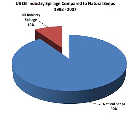
At that time it was conjectured that the tar balls had come from natural seeps under the Gulf. Cutler Cleveland recently wrote a guest post on the topic of these natural seeps, and their size, relative to the current spill, but because of the new furor I thought it worth expanding a little on what he wrote, relying on two of his sources – the National Research Council’s Oil in the Sea III Inputs, Fates and Effects (2003) ; and Dagmar Schmidt Etkin’s Report “Analysis of U.S. Oil Spillage,” which API issued last August.
In the normal course of events the magnitude of the natural seeps of oil into the waters around the United States far exceeds that from other sources. For example, to take the data for U.S. waters:
A natural seep occurs when the oil, which is normally trapped under a layer of rock in a reservoir, finds a pathway to the surface, generally relatively small (so that the oil doesn’t all gush out rapidly), with the oil slowly seeping upwards over the centuries.
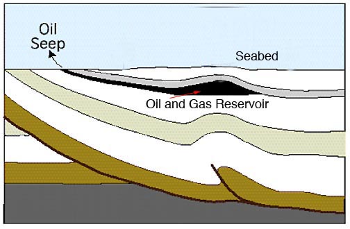
Worldwide seeps can add up to more that 14 million barrels a year, and in the Gulf of Mexico the NRC report suggests that the annual flow from the seabed is around 1 million barrels/year. (Etkin puts the high end estimate at 1,400,000 barrels a year). As Dr. Cleveland notes this is considerably less than the current spill (2,700 bd against 15,000 bd), but it is sufficient that it generates tar balls that end up on Florida beaches, and it is likely sufficient to also generate plumes of oil-contaminated water. Further the location of these seeps, not surprisingly, is where the oil rigs are likely to be found (since they are drawing oil from the reservoirs). Thus it may well be, in this case, that there is some confusion between natural seeps and the entirely un-natural and much larger current spill.
Etkin mapped the location of the seeps that have been reported, and areas where the sheen of oil that they generate on the surface has been remotely detected.
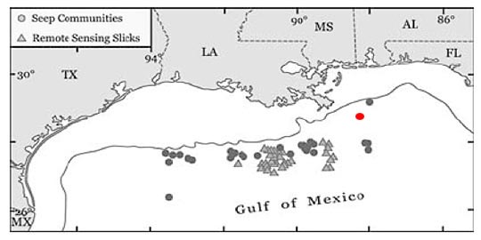
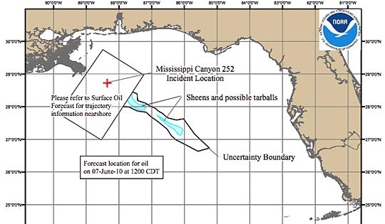
It is perhaps useful to locate the Deepwater Horizon oil spill relative to these. ( I have put a red dot on the above map where I estimate it is, but this is the NOAA map showing the well location and the surface sheen today (June 7th).
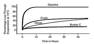
The surface sheen will, unless continually fed with new oil, tend to shrink over time as the oil that comprises it is light enough to evaporate. The NRC Report notes that there are a variety of ways in which the oil will meet its fate.
The NCR report provides this graph for the evaporation rates (but remember that this is likely only valid for the very thin layer of oil on the surface).
In many oil spills, evaporation is the most important process in terms of mass balance. Within a few days following a spill, light crude oils can lose up to 75 percent of their initial volume and medium crudes up to 40 percent. In contrast, heavy or residual oils will lose no more than 10 percent of their volume in the first few days following a spill. Most oil spill behavior models include evaporation as a process and as a factor in the output of the model.
On the other hand emulsification (where the oil mixes with water to generate the brown chocolate mousse type of structure that is now appearing along the beaches, marshes and estuaries) increases the volume of the oil by perhaps 3 – 5 times. This is the most visible result of the spill, with the long strands of emulsion that are now evident on the sea surface and which are now entrapping birds and other wild life. It is not, however, likely to be the most dangerous.
That comes from the concentration of small oil droplets in the water. While these are small enough to be an easy target for microbial action, and in that process of being digested, reduce the risk of tar ball and sediment formation which is often the long term result of an oil spill, before this plume is destroyed it can be lethal to those bethnic resources that it encounters. Following the wreck of the tank barge the North Cape off the Trustom Pond National Wildlife Refuge in New Jersey the impact was devastating.
Nearshore benthic resources were greatly impacted, with estimated mortality of 9 million lobsters (mostly juveniles), 19.4 million surf clams, 7.6 million rock and hermit crabs, 4.2 million fish, and 2.8 million kilograms of amphipods and worms
In that case, however, the wreck was pushed ashore at the refuge. In the current case there are miles, for some species, between the spill and their habitat.
With the breakdown in size of the oil droplets brought about by the dispersant mixed in with the oil at the well, the exposure of the oil to microbial action is enhanced, because of the very large surface areas which the droplets create. This will speed up biodegredation, but it depends on depth and water temperature, among other factors.
Rates of biodegradation are dependent on the ability of microbes to contact hydrocarbons as well as on the bacterial metabolic processes operating within the cell. Rates of biodegradation in a natural experiment range from 50 to 100 g/ m3 per day (Lee and Levy, 1987). In the environment, rates of degradation have been reported to be between 0.001 and 60 g/m3 per day (Atlas and Bartha, 1992) Source: (NRC Report – ibid)
Also, in regard to a certain BP official commenting that oil floats, this depends on the droplet size, to quote the report again:
Vertical dispersion and entrainment are the movements of oil droplets of sizes less than about 100 μm into the water column. Typically droplets that display a residence time of minutes to hours have droplet sizes less than about 20 μm (Reed, 1992). Larger droplets will rise quickly to the surface.
Unfortunately the exact droplet sizes, and their relative lifespan at different levels in the water column is going to be partially controlled by the earlier interaction with the dispersant.
That research will, no doubt, now be done relatively rapidly, given the $500 million that has been made available and the groups now doing the investigating. It will, as part of that process, perhaps be interesting to see how much of some of these subsea plumes was generated by the natural seeps, rather than the oil spill, and how the natural disposal of that oil impacts on the current much larger volumes. But again that funding is likely already starting to be spent. (Were I still doing active research I would probably grumble more about the lack of funding for research to find better ways of drilling and producing the oil – but since I’m not, I will restrain my cynical self).
And on a final note: The amount of oil being recovered at the Deepwater site has now risen to a daily rate of 15,000 bd. (But does not seem to have impacted the volumes escaping from under the cap.)
Contact
- Content: editors at theoildrum dot com
- Tech support: support at theoildrum dot com
License

This work is licensed under a Creative Commons Attribution-Share Alike 3.0 United States License.
Prof. Goose's comment:
A continued humble and sincere thank you to all who have donated thus far. It will help us pay for the fourth server we brought online to accommodate the increased traffic. (See point 3 below.)
1. The Oil Drum is a special place. We strive to maintain a high signal to noise ratio in our comment threads. Short, unengaging comments, or comments that are off topic, are likely to be deleted without notice. (to be clear--engaging, on point humor and levity, more than welcome.)
We are trying to perform a service to the public here to coordinate smart people who know their stuff with other people who want to learn about what's going on. Promotion of that ideal will be the criteria by which we make our decisions about what stays and what goes.
Flame wars, polemic exchanges, and other content deleterious to the community will be removed, either by an editor or by the community through its moderation process.
2. If you see a problematic comment USE THE COMMENT MODERATION SYSTEM--see the "Flag as inappropriate" and (?) beside it? Learn more there. If you see comments that are questionable after you've done that (that aren't being removed), let us know at the eds email address.
It is up to this community to enforce the norms we have established here (a high signal to noise ratio), keep. it. up.
Our guide to commenting at TOD can be found here: http://www.theoildrum.com/special/guidelines . Please check it out if you are unfamiliar with it, but it is essentially 1) citations welcome (if not necessary), 2) be kind to others, and 3) be nice to the furniture.
3. We have gotten a lot of queries whether this bump in traffic is adding costs to keep the site functioning. Truth is, yes, we are incurring added expenses from these events. It is also true that we try not to beg from you very often as we are not the types to bother you with constant queries.
That being said, if you are inclined to help out, your support is always welcome and very much appreciated. To those who have already given, thank you very much.
You can find the donate button in the top left hand corner of the main page.
4. If you have come here to vet your plan to kill the well, understand that you will be queried on whether or not you have read the other 10 previous comment threads and all the myriad plans that have already been run by the kind folks in this room; if you have actually read all 10 comment threads and still think your plan has legs, well, then maybe yours really is the one that will save the Gulf of Mexico.
This is not to say that well considered questions about current attempts and modifications to those attempts are not welcome; they are. But try to place them in context and in what's actually going on, as opposed to your MacGyver dream solution where you have a 10 megaton bomb, an ice pick, and Commander Spock at your side.
5. Also, if you're looking for live chat to talk about the ROV/LMRP video, etc., and are IRC capable, go to freenode, the channel is #theoildrum
(google MIRC and download it; Hit the lightening bolt and fill in your info; select the server as "freenode" (it is in the server list), hit connect; when connected type /join #theoildrum)
or you can get there just via a browser: http://webchat.freenode.net / Just enter a nickname and #theoildrum in the boxes; then when connected type /join #theoildrum)
6. Don't be afraid to go back and read the last couple of open threads yesterday and today before you start on this thread. They are really good, and will likely catch you up if you have been out of the loop for a while. We shut down threads when we get to 300-400 comments, as it's really unmanageable. Lots of good stuff in there though.
If the well casing has been compromised (i.e., leaking), it's quite possible that oil is flowing out into cracks or fissures in the subsurface geology and surfacing through the seabed some distance away.
In other words, there may be multiple release points. Oil flowing through (uncased) openings could be virtually uncontrollable, depending on the nature of the opening (location, size, shape, etc.).
Also, what this means, if true, is that sealing the well won't work (unless it's somehow sealed at the bottom). It also means the relief wells won't have any meaningful effect on the amount of oil spewing into the Gulf.
Things are going to get a whole lot worse before they get worse.
Also, many people probably saw via ROV video the massive explosion that happened last week. I saw lots of opinions about what caused it expressed in this forum. I believe that the explosion could have been the floor of the seabed blowing out.
What you saw was an ROV drift into the plume last week (looked like it lost grip on the BOP).
Also the relief wells intercept the original well at the bottom so they will kill leaks further up.
I am curious, would not the relief well have to not only exceed the pressure of the formation but also provide enough volume of mud to overcome the leak of mud that will exit the top of the existing well and any casing leakage of that well?
Has anyone ball-parked the pressure and volume of mud needed to do this? (sorry if this had been answered, l looked back about 1,000 posts and may have missed it).
Yes, the relief well would have to fill up the wild well bore to the top (or close) PLUS any "lost circulation" zones. Several thousand barrels of mud required. And big mud pumps (it need to be delivered faster to the bottom of the bottom of the relief well than to can flow up the wild well).
Alan
And to add to Alan's most excellent answer I'll guess the MW will be around 16 #/gallon. If I recall correctly the reservoir was drilled with 14.5 ppg MW. They can't use too high a mud MW either: that could fracture the rocks and cause them to lose the RW.
For all: In case you want to convert MW in #/gallon to bottom hole psi it's easy: MW X 0.052 X depth. I.E. 14.5 ppg X 0.052 X 18,000' = 13,572 psi.
16.0 ppg X 0.052 X 18,000' = 14,976 psi
But this calc also points out that a full colume of MW will be needed to stop the flow. If too much mud is blown out with the oil/NG it won't generate a sufficient BHP (bottom hole pressue) to stop the flow. That was Alan's point about being able to pump the kill pill fast enough to do the job. But there is a useful feed back loop: even some kill pill will add some BHP and slow the flow up a little and make getting a full column in place easier.
Blowout well reported LOT 15.9 at base of 9 7/8" liner (17,168). Hope that was not actually full formation strength (& was either an FIT or a cement bond leak.)
That is very helpful. Thank you both.
One other question: Does the downward seawater pressure have to be considered when calculating the pressure needed to force the mud up the existing well?
Of course. It also reduces the height of the column of mud needed to stop the well from flowing. The mud has to overcome the pressure differential between the reservoir and the sea floor.
RM,
When the original well was drilled, let's say with the 14.5 ppg mudweight, if they had a perfect balance, then the mud column would have balanced bottom hole pressure. But that mud column would also have included a mile long column from the BOP to the rig, which would have been at that 14.5 MW. Assuming that they could completely fill the well bore now they can only create a column up to the BOP, so the column would be significantly shorter, with the mile long column of water at roughly 8 ppg on top of that. They won't have the 18000' column of mud, only about 13000'. Even with the relief well completely filled, the pressure would force the mud up through the open riser. I would think they will need much heavier mud to create the necessary pressure within the original well, leading only to the mud line, but the heavier mud may cause problems with the RW and any open hole section it may have. Any thoughts?
Respectfully,
ej
ej – Exactly the big problem they face. You can back calc the MW they need. Taking into account the 2,300 psi water pressure at that depth they’ll need a 13,000’ column of 17.1 ppg mud to produce a 14,000 psi BHP. It was just reported that the previous csg shoe leaked off at 15.9 ppg. We don’t have the data to do the calc but I suspect the fracture gradient at the bottom hole is close to 17.0 ppg. I have no experience killing a wild flow with a RW so I can only speculate. They may be hoping that at 16.5 ppg or higher MW they may be able to force lost circulation (the drilling mud filtrate) into the producing formation and sufficient damage its flow capability enough to kill it. Of course the risk with such a high MW is fracturing the rocks in the RW. One way to offset that is to set csg as deep as possible in the RW to max the fracture gradient in it. But to set the csg that deep means you better be very close to your target: if you miss by much you’ll be limited by the csg as to how big a correction you can make to get to your target.
BP might not admit it but the mud weight/csg plan has been designed by some of the best hands in the business IMHO. From the scant details we have this may be one of the most difficult RW kills every tried.
Regarding the mud, I don't see how this is any different from the original well. For the relief well, they will have the riser full of mud while they are drilling. It is only some point down the line where they will replace the mud in the riser with seawater (as they were doing for the original). Presumably, the cementing will be improved.
The casing issues, though, are interesting.
True joules. But remember it will be the head on the blowout well that will kill the flow. The head (BHP) of the RW will keep it from blowing out (hopefully). But that brings us back to the tricky balance: the MW in the RW has to be high enough to keep it from kickin but not so high as to fracture the low out well. Do that and the mud will flow out those fractures and not up the blow out csg.
Without the details I'm not sure but a conventional kill procedure might not work in this circumstance. Just too many unknowns and such a narrow margin maybe. And that doesn't take into account any problems with csg integrety we might not know about.
Looks like BP is going to have to take that riser stub flange off after all.
Mount a valve on the top of the BOP and then prepare to pump mud down the kill and choke lines. Mud wouild flow down the relief well and back up the blow out. Once mud flows solidly from the top of the BOP, the valve could be slowly closed and mud added to the kill and choke. It wouldn't be as much mud as in a proper riser but the effect would reduce the mud weight.
Rockman:
Any wild-assed-guesses about the odds of things going seriously sideways as opposed to a straightforward bottom kill?
OK, let's see if I have this about right:
231 cubic inches = 1 gallon is used to get 0.052 unit conversion factor
Original well had 18360 ft of 15.9 ppg mud at the bottom.
15.9 ppg * 18360 ft * 0.052 = 15180 psi
The other references I've seen are about 13000 psi.
Given a seawater density of 8.6 ppg and a depth of 5067 ft provides a seafloor pressure of 2266 psi.
For a bottom kill we would need 18360-5067 = 13293 ft and 15180 - 2266 = 12914 psi. This implies a density of 18.7 ppg. In this case, the RW bottom would see 17853 psi.
Using the lower pressure of 13000-2266 = 10734 psi requires a density of 15.5 ppg. In this case, the RW bottom would see 14798 psi.
Could you "go heavy" for part of the procedure to help slow the flow, and then lighten up a bit as you work it out?
Seems like you'd want to err on the high-side anyway, as the casing will take a good bit of pressure, and you want to definitively stop the flow?
Houston, we MAY have a problem !
Add the dynamic pump pressure to the downhole pressure. Once intercept is made, the pumps will shift to high to control both wells with large volumes of mud.
Alan
Is there not a bottom plug in the longstring?? I thought there was a bridge plug in the hole. If the longstring has integrity above intersection then all the flow will be up the tight clearance annulus.
FF
3 -- I think the original hole was drilled with 14.0 -14.5 ppg mud. The 15.9 ppg figure was the equivalent MW that caused the previous csg shoe to leak.
Correct anyone?
Yes, the mud would go up the liner as well as going down into the reservoir. But because the mud will have a weight of 16 or maybe 18 lbs per gallon, which is more than twice the weight of oil, the 13000 foot column of mud (intersect point to well head) will not be leaking as much as the oil if it leaked at all. But the oil will not be flowing to the well head through the damaged BOP, so a cement plug can then be set at the bottom of well (again).
Went back and checked... it was the explosion that occurred on May 23rd, more than a week ago.
If the seabed floor itself has collapsed or blown a hole, then a relief well wouldn't have any meaningful affect.
The kicks and blowout itself indicate to me that the root cause is catastrophic gas release which destabilized the seafloor and is now allowing oil and gas to flow from additional openings.
oza - I think the failure of the topkill, was due to casingfailures, so I know regard that more of less as a fact. Allso BP was told from Gov. to stop pumping mud down under heavy pressure, as the mud just keept disapearing in to "nowhere"
The geology at the place is highly complex, with salt domes, fractures, sanddeposits etc.
I would not think it unlikely, that oil and gas was escaping fram ruptured casing and made it way to the seafloor somewhere.
Also theres a big inconsistency between the flowrates told (12-19000 bpd) and the size og the oilspill in GOM.
So either the flow fra the 20 inch pipe is a lot bigger, or theres an other / multiple sources.
Take your pick! - I havent got the answer, but the size and the spread of the spill indicates that there a lot more oil out there than coming just from this single 20 inch pipe on top of the BOP at a rate of 12-19000 bpd..
From looking at the latest maps, the spil naw has a size of between minimum 160 x 40 miles = 6,400 sq miles and maximum of 300 x 160 miles = 48,000 sq miles, depending on how one is to interpert the maps.
With enough concern and public pressure ... it may be time for BP to release it's seismic data on the Macondo prospect. We're going to have months of speculation ahead of us regarding geological strata, casing integrity, loss return zones (where were these located ... does anybody know), sand in the well bore, ghostly plumes from the sea floor, all the rest. And without this seismic data (and detailed notes on the architecture of this well), this speculation just grows in intensity and doubt over time. One thing that caught my attention ... the senior BP drilling engineer, Mark Hafle, talked about two production zones on this well. If there is a failed casing string higher up on the well, in the second production zone, what kinds of issues does this present in relief wells and intersecting the well at 18,000 feet.
Also, what this means, if true, is that sealing the well won't work (unless it's somehow sealed at the bottom). It also means the relief wells won't have any meaningful effect on the amount of oil spewing into the Gulf.
This is incorrect. There is a very high likelihood of a kill of this well after the relief well(s) intersect the wellbore of the blowout.
But not on the first try.
Alan
oz -- I apologize for being so brief but the details are just too long. If you have the time and patience you can Google for Petroleum Geology for the details.
But it's physically impossible for oil from the 18,000' deep reservoir leaking to the sea floor miles away from the blow out well. But there may be csg failures which are allowing oil/NG to be flowing into the stratigraphic section. This would be called an "undergound blowout" and has happened a number of times in the GOM. But that oil/NG can't reach the surface thru the rocks. A bad situation for sure but doesn't pollute the waters.
OTOH oil/NG could be leaking to the surface from failed csg but it would be coming up adjacent to the well head. This is also not unheard of. Long ago I had a rig sink when NG bubbled up from the outside of the csg. The NG caused the rig to lose buoyancy and it sunk.
There may well be oil leaking from the sea floor many miles from the blow out. Cound be from an abandoned well or could be a natural seep. There may be an oil plume in that area which originated at the blow out well. But IMHO there's no oil from the blow out hole leaking from the sea floor miles away from the BP well.
Rockman is an acknowledged expert. That said, I disagree about updip migration reaching the surface via a salt weld or fault. It's not an exact analogy, but the Campos reservoirs were charged by a similar path.
Rockman,
You have been more than generous in offering explanations of many procedures followed in the offshore drilling industry. Could you comment upon how the kill is done after the relief well intersects the blowout. I'm having trouble with the idea that the same mud weight will keep the relief well under control and at the same time kill the blowout which will have 5,000 ft less head since the riser is gone. Or, presented another way, if the mud weight is high enough to kill the blowout, it will give a much greater pressure in the relief well and maybe cause a something to breakdown there.
Excellent point about the missing riser. I hadn't considered the missing 5000 feet as a factor in the hydrostatic pressure that can be applied by the relief well.
I am also trying to wrap my head around the RW concept.
If there is a blowout at the casing then whatever is in the blown out well hole will want to escape at the bloen out portion. So if it is down some number of feet in the blownout well hole wouldnt that reduce the amount of head you could establish in the blown out hole?
At that point you would have to be establishing teh head dynamically by beein able to apply enough flow volume at pressure to make up for lost material in the blownout section-are the pumps able to do this or am i mistaken?
It seems to me that while the relief well has the potential for greater head due to the extra 5000' of tubing from seabed to water surface, as the mud column from the relief well reaches the intersection of the two bores, it will begin being pushed upwards into the original well. As this happens, they'll pump more and more mud which will flow upwards from the intersection into the original well. Control will be achieved when the weight of the mud column in the original well equals the upwards pressure from the reservoir at that intersection point. At that time, presumably, any extra mud pumped into the relief well will simply begin pushing downwards from the intersection. Thus, no real extreme calculations need be performed except to make sure that the density of the mud is sufficiently high to achieve control with a column height of mud that is less than the distance between the point of intersection and the sea-floor (also taking into account the helpful sea-bottom water pressure which will not be seen in the relief well).
Of course, the mud density will be much greater than that of sea water so the relief well will have an "advantage" versus the original bore.
Initially, as mud pumping begins after the intersection is made, the flowing oil/gas mixture will mix with the mud somewhat so the density of that mixture in the original bore will be lower than that of the pure mud. But the higher density mud will "win" if they can pump enough volume of mud fast enough. It seems like it ought to work.
That would work in a static load situation. I am seeing that if the blown out casing is at a point lower in the well than the head pressure that needs to be established (equal to or just slightly greater than the highest pressure at the source resorvoir) the mud will flow into the blow out location and the required pressure will not be obtained or maintained (depending on the flow rate escaping and thereby removing mud from the oversall system into the blowout location)?. If the pumps cannot dynamically keep up a high enough flow rate into the system at the RW mud insertion location to overcome the blow out hole mud removal flow, a pressure will not be able to be obtained or maintained that would be greater than the source pressure neeeded to then plug at bootom?
Just a mech/mats eng. here very concerned, trying to understnad and hoping all will work.
I see what you're saying. I think it would depend on what/where the blown out casing is communicating to.
If the blown out casing simply communicates into the drilled bore hole, then the only consequence would be that more mud would be needed because you'd be filling the entire bore, and not just the casing.
If there is a leak into the rock formation somewhere, then that formation that's "stealing" the mud (and presumably oil and gas, too) would need to be plugged off somehow. From the little I know of geology and oil formations, I think it would be unlikely that the leak would be unconstrained into a lower formation like that.
I wouldn't think that a breach would find its way into such a porous area of sediment (down low enough to matter) that it would eat up unlimited amounts of mud. Instead, I'd imagine the mud sealing off the tiny pores in the rock layers very quickly, thus allowing the drilled bore to be filled with mud.
But, since "top kill" didn't work, and there's speculation that the reason was that the mud was being lost into a breach someplace, it makes one wonder.
I guess what I'd hope is that the breach that may have made "top kill" ineffective (assuming it exists) is up fairly high. High enough that it was a concern that it'd blow up around the casing and create a more difficult problem, and that's why they stopped. And if that breach is up high like that, that would leave enough of a "sealable bore" below it that the necessary head could still be achieved if dense enough mud is used, but it must be injected from below, of course.
But it is an interesting point!
What I'm trying to understand is how the two can be balanced except by a great deal of trial and error.
Consider a situation where there is a U shaped garden hose. Raise one side of the hose so that it is 5 ft higher than the other end. Now put some combination of fluids in that high end in a manner that causes the fluid level to be right at the top at each end of the hose.
Maybe my visualization is just off and that is making it hard for me to see the solution. I realize that the well does not have to be filled to the top to kill it, but they still have some sort of balance problem with the large difference in elevation.
The way I visualize it, they should not really need to balance things.
They'll have more potential head available in the relief well because of the additional 5000' of pipe going from the seafloor to the ocean surface.
Now, if they pump heavy mud into the relief well, it'll go down and flow into the intersection point. If they pump enough in, it will either come out at the ocean floor (meaning they're not using dense enough mud) or it will start flowing downwards into the oil/gas reservoir.
If the mud is dense enough, the flow of oil/gas is killed at that point. So all they need to do is just leave it that way (at least temporarily).
In effect, the system will find its own equilibrium if they pump enough mud into it.
The height of the mud/oil-gas interface in the original bore will "seek" a point that is indicative of the reservoir pressure once they stop pumping mud into the system IF they use dense enough mud.
Envision a garden hose connected to the bottom of a pressure tank half full of oil, half full of air above the water. That garden hose goes up about ten feet, then you have a tee to which you connect two other garden hoses. One is 20 feet long, the other 30 feet long. Those hoses are held up so that they go more or less straight up.
You put enough air pressure into the top of the tank that it pushes the oil up the hoses past the tee, and up until it's starting to push up out of the top of the shorter of the two top hoses.
Next, you start pumping heavy mud down the longer of the two hoses. When that mud hits the tee, it will start pushing up the shorter hose. If the mud is dense enough, when the column of mud in the shorter hose reaches some point lower than the top end of the hose, it will stop rising in that hose and start pushing downwards into the single lower hose towards the tank.
At that point, the flow of oil up out of the shorter top hose will be killed and you can just stop pumping mud and the oil well is temporarily killed.
The system will find its own balance right there.
You could keep pumping more mud if you want, but just stopping should be sufficient unless things leak.
Back at the real system: Let's say you just stop pumping in mud and actually open the top of the relief well to the atmosphere. The mud will just drop in that new pipe (as if it's being pumped) until its level finds a point where it is in balance with the rest of the system. Presumably, since it would have only air above the mud (instead of water and oil) that level will be a bit above the mud/oil-water interface in the original bore. But regardless, those levels will simply find themselves and all will be balanced.
Of course, that's in a perfect world :)
Your perception is valid Auggie...see my response to ej above. Again, I have some experience with pore pressure analysis of DW GOM wells but no direct experience killing a blow out with a RW. A few blanks I can only guess at.
Thanks for the response. Perhaps one of the well control experts can post something with a possible explanation or an idea of how the plan could be carried out. If there is a casing leak somewhere down the hole it will further ccomplicate the balance problem as it effectively increases the elevation differentials and limits the column of mud that can stand in the blowout well. An earlier response in another thread indicated that the wells must be stabalized before the cement is run in the hole so that there is not just a mix of cement and mud in the blowout well. With that in mind, it seems that it will get more complicated as the weights in the different columns will change as the cement travels down the relief well and into the blowout. I can see that there can be some trial and error on the balance of the mud weights but that cement job seems that it will just about be a one time shot as the hole will full of junk after that. Or maybe if is not killed then it is still flowing and can be pumped into for another balanceset up and another cement pill.
I agree there could also be oil flowing through an abandoned well or natural seep, as well as through new openings, but the point being that what got this oil moving, in so many words, is communication via the blowout hole between existing permeable layers or destablization of the seabed floor itself due to catastrophic gas release.
Natural seep is younger, shallower, and biodegraded. I can't see the abandoned well scenario being linked to Macondo. Nothing was previously drilled nearby that I'm aware of.
Daily Wildlife Collection Reports (you can bet these are a tiny fraction of the actual carnage)
http://www.fws.gov/home/dhoilspill/collectionreports.html
(the following video is raw footage without commentary of some of the wildlife devastation)
http://www.youtube.com/v/V6qMrYr7kxk
http://www.dumpert.nl/mediabase/980021/f9ad0b2c/bp_zegt.html
Since the story about what Senator Bill Nelson said was "broken" at emptywheel (Ph.D.) by bmaz (lawyer) I'd like to repost a comment I just placed on an earlier thread, which speaks to the integrity of both Marcy Wheeler and her site and her sidekick, bmaz. My comment follows this link to it:
http://www.theoildrum.com/node/6572#comment-644223
Marcy Wheeler has been doing political commentary via blogging for many years now. And her Ph.D. was for research on the kind of writing people did in Eastern Europe under communist regimes, where the writers were looking at what the govt was doing and hiding and how powerful folks can "hide" the truth and the little people are trying to ferret it out.
This group at emptywheel is closely monitoring TOD. And they have lots of energy, skill, and analytical abilities.
At this moment we need all the technical expertise of TOD and all the political analysis and skills from groups like hers (and people like me) as well. This is a huge endeavor, trying to trace what's happened and trying to analyze how best we, as a society, can disentangle ourselves from ways of living which must change.
As for Marcy Wheeler's integrity, please see this blog I wrote last year on Marcy Wheeler and Freedom of the Press:
http://tpmcafe.talkingpointsmemo.com/talk/blogs/therap/2009/05/ma.php
Full Disclosure: I have no connection with Marcy or bmaz, other than having sometimes posted on their threads. I have donated to her site, just as I have donated to this one. But my respect for her, as for TOD, comes from my own personal evaluation, based on the writing and integrity I have observed. In the end all of this comes down to mutual respect and efforts of all of us to work together for the common good.
Good comment TheraP.
I can't handle any politcal stuff about this.
It is too serious and my interest is in the practical aspects of this.
Maude, the beautiful thing - to my mind - is that we're working together! I'm just trying to do my little part as best I can.
I do have a blog up on the practical right now:
http://tpmcafe.talkingpointsmemo.com/talk/blogs/t/h/therap/2010/06/relie...
I'd rather hear about (and see) their data than hear about their integrity. How do they know that there's a major unrevealed seafloor oil leak?
I think their only source is Nelson's office. They called and got confirmation that Nelson and his people knew the serious significance of what they were suggesting.
That is correct.
They do a good job of posting accurately the news that they gather. Only Senator Nelson can verify the "source" of his info, but they presented the senator's words as "news" and they are following TOD in addition to other aspects of this oil spill, for example the criminal liabilities.
I have firm evidence of that from a link I found here on TOD: http://www.marinetraffic.com/ais/
As of this post time, NONE of the vessels involved are showing up, whereas all of them were shown last Friday. The only possible one left is Doreen McCall [US]. Earlier this morning Boa Deep C [ML] went off the plot. (I wonder if this post will "hide" the Doreen !!)
Just more indication that BP is trying to hide its activities, and massage the messages that we are allowed to get.
Many thanks to TheraP, Gail, Prof, and all of the rest of the knowledgeable folks adding their expertise to these discussions. I'm one of your Noobs that has learned quite a bit about the heretofore hidden technology and procedures, and just how dangerous some of it can be. It's definitely well worth the paltry few bucks I dropped in the kitty to help keep the site on the air - many thanks.
The thing that's different about this spill is that many eyes are scrutinizing each and every clue, fact, myth, spin, whatever... via the web and all the good folks posting the news as it flows in, analyzing, teaching each other, critiquing are cooperating in a huge common effort - doing this without pay, for the good of all of us. And kudos to you for following up on the marine traffic! We can't let any of these anomalies disappear from "our" radar screens!
This time the "little guy" has an internet and many eyes working together - all trained on the "powers" that are trying to take away the environment we all share and need for our mutual survival.
P.S. I was only promoted to TOD "Freshman" on Sunday - and am waiting for the promised "pop quiz" today... ;)
Ok, a Pop Quiz for TheraP and any other newbie that wants to join in.
What is ELM (Export Land Model) and what will the impact of ELM be ?
What is the year of Peak Conventional Oil (crude + condensate) ? What is the year of Peak oil Exports ? Explain why and how you came to those conclusions ?
Are the Saudis lying about North Ghawar ? Why does it matter ?
What is the range of times from first discovery of a giant oil field and both first and maximum production from that field ? Why are lead times important ?
Hint: See Kashagan for maximum time. Extra credit, how many billions will Kashagan take to fully develop ? (another hint, the nickname for Kashagan is "Cash all Gone").
Extra Credit: Why do I support "Efficient Non-Oil Transportation" and what are the four modes I support ?
Best Hopes for this take home quiz :-)
Alan
Gee, Alan, I've been reading TOD for four years, and I'm not sure I could answer more than about the first three...
I do grade on a curve >:-)
And it is an open book quiz !
Best Hopes for Inquiring Minds,
Alan
And some of us lack the time to work difficult quizzes.
I'm assuming one of your non-oil transit modes is "bicycle", ridden by people eating not-too-much mammal meat, perhaps with electric-motor assist, because there is no more efficient way of moving people, short of packing them into a coal train.
I can think of two reasons for the Saudis to lie (upwards) about the size of their oil field. #1, it gives them a larger share of the OPEC quota, hence more money. #2, if enough of the US population perceives peak oil and actually acts on it (seems unlikely, but you never know) our reactions range from a takeover over the Saudi oil fields (hawkish right wing reaction) to a pell-mell flight towards non-oil energy (and perhaps a collapse in oil demand, though that seems not too likely) (that's the left wing reaction).
First question. In the two essays I was asked to read, the acronym ELM comes only in the comments section. Here:
http://www.theoildrum.com/node/4172#comment-368873
and here:
http://www.theoildrum.com/node/5582#comment-521223
Best I can do....
;)
ELM comes up in almost every comment section that Westexas visits. :)
For extra credit you'd have to expound upon ELM v2, and the Chinidia impact.
Ok... can I go back to newbie, please? ;)
Nope, unfortunately a journey down the path of enlightenment, once started, is difficult to reverse. Sorry.
ELM is export land model, a first-approximation model of national production, internal consumption, and export which indicates that an oil-exporting nation's internal consumption tends to grow as a fraction of the production total over time. When that nation passes production peak, the trends reverse, but internal consumption slides more slowly than the production decline, so the export decline is much higher in percentage terms than the underlying decline.
This means a small drop past-peak for a nation or the world will rapidly become a large drop felt by oil-importing nations.
V2 adds the notion that developing nations gain a higher utility from each new barrel of oil than mature economies, and therefore growth nations like China and India will tend to outbid western consumers for a marginal barrel of oil. This will likely mean that post-peak the western economies will eat the bulk of the decline, especially at the outset.
It is worth noting that growth in Chindian consumption roughly matches the drop in western consumption during the recent recession. Apparently a small truck carrying 10 workers in China can afford gas more readily than one US commuter in his F150 can?
Apologies if I fractured WT's premise. I kinda glaze over when I hear ELM by now.......
Here's an interesting analogy that just came to mind as I tried to wrap my neurons around your explanation:
Imagine a developing nation on one teeter-totter with a barrel of oil. And an advanced nation ... same thing. The "barrel of oil" has more power on the developing nation teeter-totter. But the advanced nation overwhelms the power of that one barrel of oil.
My analogy may not be a good one. But that "image" will stay with me. Helping me to see how a barrel of oil "differs in its impact" depending on who's using it. So, yes, that theory really makes sense to me. And yes, we in the developed world must bear the burden of transferring to new energy sources if we want to continue using energy. Alternatively we must bear the burden of using less energy. Because those developing nations WILL outbid us as its "value" is really greater in their economy.
This is such a great place to learn! You are inspiring me!
ELM, to me, sounds like a fancy term for cost/benefit ratio. Am I right?
No, ELM has nothing to do with cost/benefit ratio.
To be promoted to sophomore, you need to know both ELM and ELP. See comments by westexas, and you'll see these terms described and developed over and over again.
This is one heckofa path to enlightenment! And too late to turn back now... so I've been told.
Ok.... give me time. (Thanks in advance!)
ELM v2 is an e-mail reader I used to use.
Alan -- you left out the most important question: What is Rockman's favorite dessert?
I searched Wharf Rat's "required reading list" and cannot find the answer.
Pray tell us... and how is it made "post peak oil"?
Rocky Road ice cream?
No, no, no. Mud pie!
Dessert? Hell, I thought it was the main course!
Blue Bell ice cream, but I never noticed you mentioning a particular flavor !
Best Hopes for Brenham (and Shiner), Texas :-)
Alan
Question #2:
The word "peak conventional oil" does not appear in either article I was told to read. Pop quiz can only include info from the reading list!
OK... skipping right to extra credit: How about bike, walk, canoe, and train?
I hope I don't get kicked out of here! ;)
Alan's from Big Easy. Some will recall "A Streetcar Named Desire", but Alan's desire is named.......
More back-up relief wells!
I think I'm right!
Kashagan billions: In 2007 dollars, 2020 dollars, or 2100 dollars?
I'll give it a try without doing to much searching...
1. ELM is the idea that exports decline faster than total production because of internal consumption. If an exporter uses 50% of it's total production, then a 25% drop in production = a 50% drop in exports assuming internal consumption stays level.
2. Debatable? 2005-2008?
3. Not sure about that specific field, but it doesn't make much sense that their quoted reserves never change. Since they are the "swing producer" it matters a lot if their production is likely to crash or if it will remain flat or even rise.
4. Couldn't say... I'm guessing a year or 2 to start producing and 15 or more to reach peak.
5. Non-oil transportation seems like a no brainer: walking, biking, and electric rail seem like the obvious ones. The benefits are countless.
Yes, a little tough, but so is TOD !
Let me see how I do.
What is ELM (Export Land Model) and what will the impact of ELM be ?
Oil exporting nations will supply their own demand first, and domestic demand is growing in oil exporters. Higher oil prices create booms which increase domestic demand even more.
from memory, Russia 2008, Oil production up +0.2%, domestic demand +6%, exports -1.8%
Once oil production begins falling, domestic demand keeps growing so exports are rapidly squeezed out (until they are close to zero, then oil exporters may do something to restrain domestic demand).
Implications are VERY bad for oil importers like USA post-Peak Oil as exports shrink faster than production.
What is the year of Peak Conventional Oil (crude + condensate) ? What is the year of Peak oil Exports ? Explain why and how you came to those conclusions ?
Likely 2008 for Peak Conventional Oil, 2005 for peak oil exports but some "discussion" on this. We could still hit a new peak. So far NGLs (natural gas liquids), tar sands and bio-fuels (in that order) are expanding and helping meet demand.
Are the Saudis lying about North Ghawar ? Why does it matter ?
Series on TOD by Stuart Staniford (WORLD class analysis, best I have ever seen on ANY subject) proved that they are. North Ghawar is about to water out. When world's largest (by far), and one of the best reservoirs, goes away, we are past Peak Oil. We simply cannot offset it's decline combined with other depletions.
What is the range of times from first discovery of a giant oil field and both first and maximum production from that field ? Why are lead times important ?
Absolute minimum is 5 years and 7 years to first and maximum production of a giant or supergiant new oil field discovered today. Lead times are important because we will be in deep trouble before any new discovery can come on-line. We KNOW the maximum amount of oil that can come on-line in the next half dozen years.
Kashagan, 1.5 million b/day of low quality crude in Kazakhstan, was discovered in July 2000. Largest field in last 40 years. Original first production was 2005, now 2012 (or 2013) and maximum perhaps 2018. Total investment required $136 billion.
Why do I support "Efficient Non-Oil Transportation" and what are the four modes I support ?
I support:
1) electrifying our railroads, expanding them a bit and shifting most of our freight onto them.
2) Building out Urban Rail as fast as the French (adjusting for population and work week). The equivalent of 5,000 miles of Light Rail in ten years.
3) Bicycles for Transportation :-)
4) Walkable communities, also known as Transit Orientated Development (the "other" TOD) that develop around #2
Combined, they will give a large fraction of our society and economy an energy efficient non-oil alternative for transportation, saving what oil is available for the harder cases.
As oil becomes a larger problem, many oil users can shift to non-oil means of transportation.
Best Hopes !
Alan
Why do I support "Efficient Non-Oil Transportation" and what are the four modes I support ?
ahem...Alan... this was mine :>)
OK, closed book test, honor system.
In the landmark paper Peak Oil Overview - June 2008, how many comments were there?
Good luck
Oh, darn! Closed book? I am an honest person. Thus, I do not know the answer. :(
How about a motto I could learn instead?
Thank you, however, from rescuing me from Alan's test - though I think may have managed the extra credit part - or part of it anyway...
Best of all, I'm good with the ribbing!
Please don't kick me out of class! ;)
Yours truly, The Freshman
You fit right in.
We're all bozos on this bus.
I think the full quote is "we are all bozos on the bus of life."
Interesting. I, too, was looking at them last week when I was tracking the R/V Walton Smith, the vessel used by the research group with Dr Joye onboard.
I wonder if their absence now is due to some kind of transmission glitch or if they're now deliberately absent due to security or some other concerns. Will they reappear later? I'm sure a number of us will be checking.
Horizon distance for a shore-based antenna at 100 feet elevation is about 12 miles. 16 miles for an antenna on a 200 foot tower. If I recall correctly, the Horizon site is about 48 miles out.
This means that all ships involved are beyond horizon line of sight for VHF communications. (AIS communicates in the VHF band, I forget the exact frequencies as I haven't worked with AIS since 2007 but I think the two channels were around 162 MHz.)
BLOS propagation occurs frequently at VHF over the water (typically due to tropospheric ducting overwater) but it doesn't ALWAYS occur.
I'm fairly certain that most of the vessels involved in handling this spill are large enough so as to require AIS per SOLAS regulations (But my expertise in that area is limited - I'm an RF engineer that did some AIS receiver work a few years ago), and turning AIS off would put BP in hot water with maritime safety authorities. They're in enough hot water as it is, so chances are that the variations you see in numbers of ships showing are just variances in RF propagation due to weather changes.
Many thanks for the information and detail on the AIS. I'm not certain as to when I first picked up on that site, but it was about ten days ago. I do know that nearly all of the vessels were showing, and they have been dropping off over the past three days. Somehow I doubt that BP is worried about more hot water at this point - they seem to be more concerned with shoring up their bottom line by obfuscating the details of their operations. Just as certain corporations have fogged their locations on Google Maps (zoom into Rt.104 and Lake Ave in Rochester, NY for Eastman Kodak), it's quite possible that BP has pulled their visibility on the open, public presentation of the Live Ships Map.
Corporations will always do what they need to to protect their P&L - and it's become very apparent that the main purpose behind their actions with governments and each other is to pass off their liabilities to the Societies Commons while retaining the profits for themselves.
We the People ... has turned into US the Corporations .... :^(
Google Maps blurring - That comes from the Department of Homeland Security. The source data Google uses in NYS is blurred by its creator, New York GIS - see http://www.nysgis.state.ny.us/sensitive_unavailable.htm. Pretty much if you have a government contract of any sort with the DoD, you get blurred even if the blurring really doesn't do anything.
Turning off AIS on their ships would be a major safety issue for BP. When you're already under investigation for potential violations of government regulations, intentionally violating international maritime safety regulations would be a very bad idea. If there were vessels in the area but BP-owned ones missing I'd think something fishy, but right now it's a pretty much empty area. A slow dropoff over a few days is consistent with a change in radio propagation due to different weather conditions.
PhilMB wrote:
Just more indication that BP is trying to hide its activities, and massage the messages that we are allowed to get.
What "activities" do you think BP is trying to hide? The fact that the oil is leaking? That's on live video feed virtally 24/7. Do you think BP is trying to hide the hundreds of ships that have deployed 3+ million feet of containment boom? If so, why do they disclose what they're doing at their web site?
As for the notion that BP is able to "massage the messages that we are allowed to get" -- that is hysterically funny. The "message" that people are getting include everything from constantly-repeated claims that BP deliberately, at the corporate managment level, decided to risk this disaster for the sake of a trivial addition to profits -- to the claim that BP is not actually trying to stop the leak and that all the ROV video is a "dog and pony show" to distract us from the real problem -- to the claim that the Gulf of Mexico is premanently dead -- to the claim that the entire Gulf fishing and tourism industry is permanently dead -- to the claim that the oil is going to reach the Atlantic and kill it as well.
Where, in the face of this massive tide of claims regarding impending doom and corporate villainy, do you see any evidence that the "message" has been "massaged"?
On a previous thread Marcus posted this link of a satellite picture asking what it represented
http://ge.ssec.wisc.edu/modis-today/index.php?satellite=t1&product=true_...
Looks to me like the large gray area (between the blue ocean and the green land) is the oil deluge (no longer a slick) which is far beyond being dabs of reddish sheen. Anyone have a different explanation
That would be consistent with this video posted by greenman3610 on youtube of this heavy goop hitting the shores. We see on the news pictures of tiny tar balls being picked off of relatively pristine beaches. I presume that is because they do not want us to see this http://www.youtube.com/watch?v=H9-k9UhAjgY
I've seen video and still photos of birds trapped in similar areas from this leak, both on the internet and MSM, so they aren't being hidden. For the ones that heavily covered in oil, though, I hope they are euthanized quickly, rather than using scarce resources in trying to fruitlessly save them.
I agree there should be more of these videos circulated on news programs; everyone needs to see them to understand what is happening.
For that matter, BP could earn themselves some brownie points and good PR (lord knows they need some right now) if they would start funding 100% these animal rescue hospitals and groups trying to save these animals. All of them along the Gulf are in emergency mode right now, they need more of everything and nearly all of them are volunteer groups. BP could announce they were making $10 million available for these groups to use for whatever they're short of, and the corporation would never even notice it was gone.
I agree there should be more of these videos circulated on news programs; everyone needs to see them to understand what is happening.
I don't know what purpose it will served... We know that there are tribute cleansing in part of Africa non stop for the last nth years.. And a lot of people die of povety in that part of the world as well.. what does constantly showing the same or similar pictures of bird dying serve?
What I am most interested in however is the satellite picture. It no longer looks like a slick with wisps of red and areas of sheen. I have been searching for a word - like gloop. If a big section of the gulf is as heavy with oil as the clip of the birds immersed in it we are in much more trouble than we have been led to believe. My question is, is this big grey area in the satellite photo oil in quantities such as we see on the birds?
Shares of both BP & TransOcean falling to new 52 week lows. BP nearing 35, RIG @ 46 (it was 92.50 just 6 weeks ago).
And I own 100 shares of Transocean that I bought at $88.50. When I bought them I thought that I was looking at a well managed company that stays out of the headlines.
I figure that it will take at least a year for their stock price to recover.
Excellent work providing the oil seep background info.
A layman cannot help but wonder how the leakage of all of these natural seeps can be estimated with confidence, yet it is officially "impossible to estimate the maximum flow" from the Deepwater Horizon, er, "spill".
PBS is providing four low>high estimates of flow: http://www.pbs.org/newshour/rundown/2010/05/despite-video-extent-of-oil-...
To my mind, your wonderful and succinct comment should be repeated endlessly - till we get answer on how much is, was, and will be the catastrophic # of barrels for this gusher unleashed by BP! This has been bothering me from Day 1. At the very least there should be transparency about THIS!!!
TheraP,
I suppose everyone is curious, but knowing what the approximate actual flow is won't change it, it is what it is. I expect that when it does matter, during litigation of liability for the consequences, anectdotal eveidence and expert testimony will establish the leaked voulme of hydrocarbons sufficient for that purpose. In the interim, what is the "Need to Know"?
For starters I should think designing an ideal collection cap would be quite a different task if you're trying capture an average of 10K bpd per day vs. 30K bpd. I'm no fluid dynamics expert but I know those people are out there and I can't imagine this wouldn't be important to them.
It follows that those tasked with formulating a containment solution have the best information available, it is not essential to publish such information for anyone else for now. No defense intended of the way BP is handling, or not handling as it were,of the disaster; I am simply suggesting we keep the focus on facts and reality for the time being versus a lot of superfluos hand wringing, social foot stamping, and political ranting.
In another thread, I was challenged for writing the following sentence:
I was indignantly asked to provide proof:
"Do you have reference to any statement from the FRT that they believed BP was holding back information? I'm not talking about press theories or whining on blogs. I'm talking about primary sources making the accusation." Harumph!
Well, how about here in the New York Times?
Is that good enough for you?
1. The FRT has the HD video they asked for, so what is the big deal? What is being held back?
2. Dr. Leifer is clearly rather immoderate. In the same interview he claims that eyeballing the flows after the riser was cut he believes the flow was increased not by 20%, but by "several-fold". That seems unlikely based on everything else we know.
3. As far as direct measurements of the flow, it is quite obvious that there is no way of obtaining that data given the physical constraints (no way to unbolt the riser to insert instrumentation into the flow stream). IF THERE WAS THERE WOULD BE NO NEED FOR THE FRT. Dr. Lieber is asking for something that doesn't exist and there is no way to obtain it.
There is nothing here to indicate BP has data they are not sharing.
As a follow-up, Dr Wererely of the FRTG was on CNN last night - he stated the FRTG was satisfied with BP's performance.
http://ac360.blogs.cnn.com/2010/06/08/video-questioning-bps-oil-claims/?...
Also this interview highlights some of the difficulties involved in this process.
Regarding 2: you asked a question, I supplied the reference you asked for. Actually, this is the second time I have done that. I'm sorry documentation isn't something you are interested in, or interested in acknowledging if it interferes with your agenda/theorizing.
As for "nothing here to indicate BP has data they are not sharing", that is likely the most ludicrous statement I have ever read. You most likely are the only person on the face of the planet that thinks BP is not withholding data. So now I will turn the tables. You are making a bold statement there. Show us proof that BP is not withholding data. For example, show us the pumping rates, pressures and mud weights that BP used during Top Kill. Or do you (laughably) assert that they didn't record that data? In that case, I have some prime ocean-front in SW Florida that is just perfect for a discerning buyer such as yourself.
I would think the amount leaking would be needed to arrange for the correct skimmer capacity, fire boom amounts, burning targets etc.
Or maybe the lack of correct information is why such a small percentage of the oil was contained, skimmed or burned?
Doesn't BP have a page on their website to send in solutions? They did recently. If you seriously want the world's help you need to share basic data.
Additionally the Gulf doesn't belong to BP. Spill into our property, we have a right to know.
Of course it's essential. This is a public event, just as a hurricane is a public event. The public has a legitimate interest in knowing what's going on. We pay for weather services to provide the information about hurricanes. In this case, we pay tax-funded academic institutions to have departments of oceanography and research vessels. Indeed, what we want here is the "facts and reality" of how much oil is flowing.
The only reason I can see to hide the information is to help BP evade perfectly legitimate fines which they knew about before drilling the well. So the public is being injured by the lack of information plus having to pay taxes for expenses the fines would cover. And you are telling us to be dutiful peons and shut up.
The "Need to Know" is not something of a practical nature, but derives from a profound feeling that we the interested public are being treated dishonestly by BP, and that our government is aiding and abetting BP in that process.
It's infuriating to endure their constant foot-dragging, to listen to their endless stream of self-serving, self-justifying remarks, their deliberate concealment of information, their willful under-estimations and distortions. These actions express their arrogance and their complete contempt for the people of this country and the world. They come first, and we come last, if we come at all. That's their gambit, and so far it's working.
In other words, this oil spill affair been a repeat of the same sort of things we've had to endure from Ben Bernanke et al during the recent financial crisis (concerning things like "where the TARP bail-out money went"). Even the Congress has so far failed to get an answer to that question. It's none of our business there either, according to "the powers that be".
The contrast, and maybe the only reason the truth will prevail in this case, is that despite whatever spinning continues the cause of distress is palpable and easier to understand in the instance of an oil spill.
Tried to post this before but somehow for a while the server was down:
Thank you! I'm sure I'm not the only one that feels we've been treated the way you so well describe in your comment.
We live in a free society. We, as citizens, deserve to get as much information about a disaster as we can manage to digest and handle. I understand there is litigation involved here. But that is no excuse to keep information from the public, let alone from the govt, scientists, or any experts who from their armchairs may be able to assist in devising solutions to the myriad of problems we are all facing because of this catastrophic oil spill.
Those who "question" our desire, nay our right, to information can avoid such information if they choose. But it should not be withheld from citizens in a free society - if that's what we are and hope to remain.
TheraP asserted:
But that is no excuse to keep information from the public, let alone from the govt, scientists, or any experts who from their armchairs may be able to assist in devising solutions to the myriad of problems we are all facing because of this catastrophic oil spill.
What information is being kept from the public?
Info to accurately estimate oil flow. (see lotsa comments above)
Just Wondering claimed:
It's infuriating to endure their constant foot-dragging, to listen to their endless stream of self-serving, self-justifying remarks, their deliberate concealment of information, their willful under-estimations and distortions.
Can you provide any actual evidence to back up the claims that you are making? What, in the way of information, for instance, has anyone asked BP for that they have not provided?
I'm hearing lots and lots of claims and accusations against BP -- but I'm not seeing much in the way of evidence to back them up.
A quote from up above in this thread:
Some scientists involved in the Flow Rate Technical Group say that they would like to produce a better estimate, but that they are frustrated by what they view as stonewalling on BP’s part, including tardiness in producing high-resolution video that could be subjected to computer analysis, as well as the company’s reluctance to permit a direct measurement of the flow rate. They said the installation of the new device and the rising flow of oil to the surface had only reinforced their conviction that they did not have enough information.
“It’s apparent that BP is playing games with us, presumably under the advice of their legal team,” Dr. Leifer said. “It’s six weeks that it’s been dumping into the gulf, and still no measurements.”
Would that work for you?
Sorry, that won't work for him. He is asking you to prove a negative. He is yet another of the BP astroturfers working on this and other sites.
Here is (just an example of) the specific information I am looking for and BP has not supplied: the record of the mud pumping rates during Top Kill, including mud density, sustained flow rates and sustained pressure. Even just an average, like we pumped X ppg mud Y hours at Q bbl/minute at Z pressure. I defy any of these "BP is completely transparent" types to show me where that information.
Meanwhile, I'm not holding my breath.
As interesting as flow might be from a legal or mitigation standpoint, what we really need from BP is the damn well logs and strat column. Ought to be public record, since they forfeited "proprietary" interest in Macondo. We need an FOIA served on MMS pronto.
I had the same question and discovered that studying seeps is not some sort of recent "earth day" enviro thing begun a few years ago, but they have been heavily researched since the 1800s for prospecting purposes.
So, seeps had been a significant prospecting tool for a large number of professional geologists for several generations, in comparison the well has only been leaking a couple weeks and very few scientists have access to the raw data, so far anyway.
On the bright side, if the well leaks for a couple hundred years, then they'll know as much about the well as they now know about seeps.
It is very hard for me to believe that some type of sensor could not have measured the flow velocities and % of gas and oil leakages from early on! Good estimates of the total leakage could have been calculated (based on the # of leaks and their sizes) - especially as these ROVs were down there trying to close the BOP!
Experts, please correct me if I am wrong here.
Why does this matter? It just astonishes me that people are obsessed with this.
It matters because ultimately BP will be fined based on how many barrels of oil leaked into the Gulf, not how many were skimmed up or collected or dispersed. If there's no accurate measurement of the flow rate, BP will no doubt argue for years that the final volume was lower than whatever the government says it is.
It also matters because if the flow rate is known, the response teams can calculate what and how much of everything they'll need to clean it up. Right now it looks like it's just a confused "grab everything" response.
Would you assess a fine that would drive what is left of BP into bankruptcy? Good luck with that.
BP has 3,130,000,000 outstanding shares. They had net profits of about $35 billion last year and paid out about $9 billion in dividends.
If spill leaked an average of 10,000 barrels per day for 150 day the fine of $4300 per barrel would be $6.5 billion. Not even enough to keep from paying a dividend.
Drive them into bankruptcy? Doubtful.
Cause Tony Hayward to lose his job? Hopefully.
mbnewtrain:
They had net profits of about $35 billion last year and paid out about $9 billion in dividends.
That is not correct. BP had net profits last year of 16.578 billion.
http://www.bp.com//assets/bp_internet/globalbp/globalbp_uk_english/set_b...
Thanks for the link to BP's 2009 Annual Report.
In the BP Annual report "before tax profit" in 2008 was $35.2 billion. Before tax profit in 2009 was $26.4 billion.
These are the numbers from which BP could pay penalties & fines imposed by the US government.
What was earned and paid in taxes in past years won't help them much next year. What will revenues, profits/losses, and debt ratios look like for them this year, even before penalties and lawsuits?
The profit margin on oil produced will be better than last year as price for 2009 was $63/barrel and price so far this year has averaged around $70. Yes, BP will have more operating expenses, but even if it amounts to $10 billion more due to DWH blowout, I think they will not be driven into bankruptcy by US gov. penalties and fines. Lawsuits will take years to settle and an amount could be set aside each year for that purpose.
If BP has trouble paying fines and claims then they may have to sell assets to keep afloat. Or US government could claim assets through the court system and sell them to highest bidder.
Yes !
Alan
Why would you not, if you were Obama? Except of course those millions in campaign contributions, just like everybody else got.
BP gets to be the whipping-boy for Big Oil, and at a time of much public and gov't distress.
Their situation is more precarious than simple fines due to heavy pressure on their stock. They may elect to sell assets or new shares to build a bigger war-chest, but it may well be that other "assets" are rotten internally, and more wheels will pop off as the corporate stress increases.
Certainly the fine is just the beginning, and hefty lawsuits will be the next step -- too many people line the gulf, and too many are involved already - how many of the $10 per hour workers will file a $1M health suit? How many will say that economic duress caused them to sign away rights, or that they didn't understand the contract limitations, and seek redress? How many Attorney's General will file major suits that can't be out-lawyered by BP? How many other nations will take a jaundiced gaze at BP operations?
Revenues will drop due to the gulf shut-down and ill-will of customers, and regulators will now skewer them mercilessly where they let them slide before. Profits will drop as cut-corners must now be fully rounded. Those 740 egregious violations? Can't happen now. Neither BP nor the Gov't will permit it. Every regulator will have new marching orders by now -- the MMS is under scrutiny -- and every fine will be high.
Then as profits slump in their next quarterly call, more funds will rotate out of BP investments, and their price will drop further. Hedge funds will circle -- maybe they're not big enough to topple BP, but it didn't take long to kill Bear Stearns. How much short selling is already underway, as a pretty much certain money-maker? Will GS truly support them, or give them advice with one arm while selling short and then downgrading them with another?
In the meantime BP will be focusing cash on this situation instead of battling competitors world-wide. Every lion can see the weak wildebeest, and all competitors will press their advantage.
I'm not sure that BP will fail, but they will falter. Another Crown Jewel is looking shabby to me.
Obviously, I've exaggerated the downside here, but even as a conservative I'd like to see a multi-national corp take it's licks this time.
As a fellow albeit less conservative citizen.... These corps. should share in the pain when they cause a major clusterflop (oil spill, financial collapse, next?). These events destroy jobs, recreation opportunity, even lives and most of the time those responsible go unscathed.
If we are ever to effect substantial change we have to be together and maybe this fairness issue is something the American people can rally around?
Firstly, I have my own private reasons for disliking BP. I'm not an apologist for that company at all.
However, destroying the company will not hurt those responsible for the blowout (and in spite of all the rhetoric we don't know who that is).
The people hurt by destroying BP will, primarily, be the shareholders. About 40% of BP shares are owned by U.K. institutions and individuals (only 7% by individuals) and 39% by U.S. institutions and individuals (14% individuals). See http://www.bp.com/extendedsectiongenericarticle.do?categoryId=9010453&co...
The ultimate beneficiaries of much of these holdings are probably pension funds in the U.S. and the U.K.
The second major group of people hurt by destroying BP are the thousands of employees who would lose their jobs.
The third group of people hurt would be the thousands of contractors and vendors, big and small, who do work for BP, or sell goods and services to the company.
A fourth category hurt by destroying BP would be the taxing entities which receive billions of dollars every year from BP and the previous three groups. These taxing entities include the central governments of the U.S., U.K., and every other country where BP operates, as well as hundreds, perhaps thousands of state, local and city government bodies.
If BP were to be destroyed, the assets of the company would fall into the hands of other companies. I wonder which would be the most likely purchaser: ExxonMobil perhaps? Or Shell? Perhaps Chevron? None of these companies does things significantly more safely than BP. But I think a more likely buyer would be a company like CNPC, owned by the Chinese government. Such Chinese companies have a well earned reputation for ignoring safety and the environment, as well as paying bribes and cooperating with governments that support terrorists. Would those who yearn for BP's destruction prefer to have CNPC drilling in the deep Gulf?
The people hurt by destroying BP will, primarily, be the shareholders. About 40% of BP shares are owned by U.K. institutions and individuals (only 7% by individuals) and 39% by U.S. institutions and individuals (14% individuals). See http://www.bp.com/extendedsectiongenericarticle.do?categoryId=9010453&co...
>> Else the money will be paid by US taxpayers and those directly affected. Don't invest is poorly managed multi-nationals. I've lost money due to my investments and nobody bailed me out. Sux to be you, if you own some.
The ultimate beneficiaries of much of these holdings are probably pension funds in the U.S. and the U.K.
>> UK pensioners are not the problem of the US gov't. Be happy with the bank bailouts we sent. Sux to be dependent on the largesse from a poorly-run multi-national company, doesn't it?
The second major group of people hurt by destroying BP are the thousands of employees who would lose their jobs.
>> Unlikely. They would just be re-employed by the buyer of assets. I have had companies shot from under me before. Sux to work for a poorly-run multi-national company, doesn't it? Choose better next time.
The third group of people hurt would be the thousands of contractors and vendors, big and small, who do work for BP, or sell goods and services to the company.
>> They're out of work already in the gulf due to BP actions. Hopefully the new asset buyer will serve them better. Otherwise, sux to do business with a poorly-run multi-national company, doesn't it?
A fourth category hurt by destroying BP would be the taxing entities which receive billions of dollars every year from BP and the previous three groups. These taxing entities include the central governments of the U.S., U.K., and every other country where BP operates, as well as hundreds, perhaps thousands of state, local and city government bodies.
>> These same taxpayers are now paying for BPs mess, and would be well-advised to ensure it never happens again. UK and other countries are not my problem. Sux to depend financially on a poorly-run multi-national company, doesn't it?
If BP were to be destroyed, the assets of the company would fall into the hands of other companies. I wonder which would be the most likely purchaser: ExxonMobil perhaps? Or Shell? Perhaps Chevron? None of these companies does things significantly more safely than BP.
>> Numbers don't lie. BP is by FAR the worst in willful, egregious misconduct. Who could do worse than a poorly-run multi-national company?
But I think a more likely buyer would be a company like CNPC, owned by the Chinese government. Such Chinese companies have a well earned reputation for ignoring safety and the environment, as well as paying bribes and cooperating with governments that support terrorists. Would those who yearn for BP's destruction prefer to have CNPC drilling in the deep Gulf?
>> So you're saying it's OK to be just as bad as BP, and we should be glad we have no worse? With new regs and oversight maybe anybody would do better....
Would you assess a fine that would drive what is left of BP into bankruptcy?
Yes.
"In this country, it is useful to kill an admiral now and then, to encourage the others." -- Voltaire
Yes indeed. Saying "oh, we can't fine BP heavily" because of how the shareholders will suffer, or the people who would be put out of business, is also saying NO corporation can be touched, EVER, for the same reason.
Thanks; you just handed them the keys to the kingdom, if they already didn't own them.
No, people wouldn't lose jobs; if necessary I'd like to see the US seize and sell BP assets as compensation for the fines. One day the sign says "BP", the next day the sign says "Exxon" or some other company. No one loses a job. As for the shareholders, well, tough for them; they've already lost 40% of their net worth pre-leak. Should the government compensate them for that too?
Corporations need to learn that there are rules to be followed, and if they violate those rules then they can expect to be fined HARD. The current fine for spilling oil into 'waters of the US' is $4300/barrel. Do the math; BP has already racked up billions in fines, with 2+ more months of leakage to go.
That right there is why they don't provide good flow rates for the leak.
SOS: You are staring the dilemma in the face: balance retribution, rehabilitation, and restitution.
Edit Addendum: Ask 10 people you'll get 15 answers. That I know.
Eventually the flow should be pretty much all be getting captured and metered so there should be a solid number on which to base fines.
Not worth fretting about imo.
Yeah, really, 1 barrel a day, 200,000 barrels a day - it's all the same right. We don't care about accurate data.
1 barrel or 200,000 - preposterous on both ends.
Do you understand how the EPA assesses penalties?
Not only from the penalty issue, but it matters for everything BP does upstream - how much capacity to have at the surface where the oil and gas are coming out now [which for some reason, BP didn't have enough barge capacity to begin with], how big the piping, new capture system, how big the gas flaring has to be, etc etc etc are.
In the oil bidness it all comes down to rates, volumes, and pressures. If you have a handle on these, you can engineer the system correctly.
Why does this matter? It just astonishes me that people are obsessed with this.
1. Clean Water Act wisely sets fines based on number of barrels spilled. If government is to be fair, it must set fines appropriately.
2. Repair tools have to be scaled to the size of the leak. BP has already been bitten by this multiple times:
a) riser insertion tool too small to handle flow rate
b) "top kill" didn't work because the BOP was leakier than expected
c) LMRP cap is working, but flow rate exceeds capacity of drill ship
3. Variation in flow rate and gas/oil ratio gives important information about the situation downhole. Is the failed cement problem getting worse? Is the casing near the top of the hole leaking? Is the well "bridging over"?
Finally, the flow rate is *the* most important numerical data point about this problem. If you don't care about it, you either don't care about the problem, or you don't care about numerical data at all. In either case, The Oil Drum is not the website for you.
All true, but what I can't figure out is does you or me knowing the flow rate or not change any of that?
Where are you going to install this sensor?
I'd stick it on the end of the screwdriver the BOP was using. And I'm talking right after the spill and till they cut the top of the riser (if I'm using the correct terminology). It would be like a thermometer but it would measure velocity of the flow. And somehow... there would be a way to gather % of oil and NG.
Once the riser was cut, it would be installed in that large pipe, measuring the increased flow due to the larger orifice. And it would be constantly sending these signals...
Of course, I'm not an engineer but you asked. And that's my imagined solution. I'm sure if you give me more time... I can dream up a better answer.
I still maintain that it boggles the mind to think good estimates could not have been given from the start - and right along. And why am I concerned? Because oil is gushing into a a huge body of water, which connects with an ocean and thus with all the oceans. And I care!
As has been said many times on these boards it IS very difficult to determine an accurate measurement of the flow. You can't simply stick a pitot tube into the flow to determine the velocity. This is basically how aircraft (and some submarines if I'm not mistaken) determine their speed. Even if you could use a pitot tube, you can't use velocity to get a good measurement. We know there's some constriction at the BOP which causes the flow to be very turbulent, and any video velocity measurements will be hard to make with any certainty. Remember the Purdue professor estimated 70,000 bpd from the video and said it was much higher after seeing it with the RITT in place. He is also part of the independent group put together by the gov't to determine flow. Their preliminary "low" estimates are 12,000 - 19000 barrels/day which is what most folks are using. Also with the oil billowing out mixing with seawater the gases are forming hydrates that can affect measurements as well. The uneven nature of the flow and consistency of the oil/gas coming out of the riser makes it almost impossible.
My first post and I’d like to thank the oil drum for hosting this discussion and all that have/are contributing!
I’m not an expert on oil leaks, but a vented - pressurized reservoir will have an exponential decline rate, which means a lot more oil & gas flowed initially and we can expect it to taper off to ~ zero as time goes on (years?).
I too would like to know more on how the EPA fines will be calculated and the amount of recovery BP will required to do. … right now, mushroom farming is the PR mechanism and dilution is their principal solution.
The only thing I'm sure of, if we assume the highest estimate (200k bbl/day) is what we will use to assess fines, BP will have $20 billion reasons to ensure a dozen experts have all the tools and data they need to calculate a reasonable, technically justifiable, number.
Absent a reason to change what is obviously working, it is naive to think they are going to do anything but try and stretch America’s and the news media, attention span to its bla bla limit.
In this case, time is their friend and as long as their lawyers can keep us in the dark, they will!
Measuring flow is not easy. You need to have physical control of the flow stream i.e. moving it through vessels and instrumentation specifically designed for the purpose and even then there are inherent inaccuracies especially when dealing with multi-phase flow though you should be able to get pretty close. Coming up with numbers based on looking at video of flow into the ocean under these circumstances is probably an exercise in futility. My understanding is that BP initially expected this to have the potential of being about a 12,000 bbl a day producer so I'd be surprised if even under absolute open flow conditions it was as much as twice that.
Well Flow Modelling
----------------------------------------
There have been a lot of posts about pressure and rate calculations for the Macondo wellbore. As far as measuring flow rate goes, there are two main ways of doing it in normal oil field operations :
- meter it (!) This required passing the full well stream through a multiphase meter, or separating the phases and measuring them individually.
- build a model of the reservoir / well bore system (generally matched to real data) and infer the flow rates from observed pressures either at the well head or down hole or both
I can go into the various meter designs that are used if anyone is interested, but thought I'd start by sharing a couple of calculations that illustrate the sort of wellbore modelling tools that are commonly used in the industry based on the limited available Macondo data.
Models are generally based on empirical correlations which calculate pressures and temperatures incrementally up the wellbore by subdividing the system into a large number of nodes.
The core of the model is a geometrical description of the wellbore flow path (be it annular or up a production tubing) which describes the well in terms of lengths of tubulars of different sizes and includes any restrictions due for example to subsurface valves or other completion equipment.
The model also carries a reservoir fluid description which allows it to track changes in phase and fluid properties with reducing temperature and pressure as it travels up the wellbore. There is a description of the geothermal gradient, and of the heat transfer coefficients which regulate heat loss out of the wellbore into surrounding rock or water.
An example of a typical industry software package is here :
http://www.petex.com/products/?ssi=3
Output from this tool for some very simple models of the Macondo well are shown below in 1) and 2) for illustration, assuming flow up the annulus behind the production casing, and modelling flow from reservoir to seabed only.
1) Plot of pressure and temperature with depth for well producing 10,000 stb/d, matched to FTHP 3500 psi, FBHP 9000 psi. To force the match I reduced the size of the annular space along the length of the production casing cement job to simulate tortuous flow path through failed bond.
2) Same again but for flow rate of 20,000 stb/d. More restriction to flow needed along cement job. Note higher wellhead temperature.
3) A similar plot for the 6 inch drillpipe to surface flowing at 10000 stb/d (depths on y axis are now with respect to sea level, not sea bed). I adjusted this to match a notional target operating BHP of 2400 psi to provide small positive pressure in the LMRP cap. This would require choking the flow to a flowing pressure of around 1400 psi at the Enterprise. Higher than I was expecting, but the tubing id is relatively large and the oil is quite gassy which dramatically reduces the effective density of the oil column at these reduced pressures.
4) A different kind of plot showing the pressures required at sea level to maintain 2400 psi in the cap at a range of different flow rates. The left hand axis is the pressure at the bottom of the drillpipe in the cap. Each red line represents the pressure required in the cap to produce at the rate on the x axis given a particular surface pressure (lower line is 1200 psi, each line above increments by 100 psi). To go to 20,000 stb/d for example will require a surface pressure of 1200 psi.
This is superb!
Does it much matter how much the water split might be? Or the GOR?
From these graphs it appears that much higher volumes are possible given the 1200psi blocking pressure, so the realistic limit is upon processing, not transport up the tube?
You didn't read the actual reports on the seeps. They are NOT estimated with confidence at all. Estimates vary all over the place and the statements in the reports are that numbers are likely to be very approximate.
Did the layman read what the degree of confidence interval was that was associated with the quantity extimates of the seeps in the GOM?
A Dutchman posted a link to a satellite photo and asked for interpretations
http://ge.ssec.wisc.edu/modis-today/index.php?satellite=t1&product=true_...
Most of the brown/grey at the bottom of Louisiana is silt from the Mississippi River, drifting westward, not oil.
Numerous white dots are small clouds formed by evaporation, the beginning of possible afternoon thunderstorms. Few Europeans can imagine the heat and humidity of South Louisiana in the summer. Clouds form quickly.
Not sure that I can spot any oil at all from this.
Alan
Good evening, Rockman, Shelburn, et al:
Which country has the most safety conscious and stringent offshore drilling, completion, tie-in and pipeline regulations?
Where do I find the UK Offshore Drilling Regulations?
I will be advising the NOC of the country that I am working in to review the tightest regs, compare to existing regs, and adopt the tightest. They have a short distance of coastline which is a rift basin ...
Thanks for your help.
HF - for most strict regulations, I belive you have to look to Norway.
Yes, with a supplemental look at Brazil for deep water regs.
Alan
Alan: See John Winthrop's 1630 sermon "A Model of Christian Charity" from which the famous phrase "a city upon a hill" came. In a global world, we still cling to the ideal that Americans must remain pure. The corruption of Europe life pollutes all "foreign" thinking. "What a long, strange trip it's been."
I. Norwegian Petroleum Directorate (NPD)
The Norwegian Petroleum Directorate (NPD) is a public body that has been assigned authority to regulate the exploration and exploitation of petroleum resources, in order to monitor and ensure safe and appropriate drilling activities.
The framework of petroleum activities is thus a regulatory concern of the NPD, and matters of safety and working environment are being supervised (audited) to see if standards are perfectly acceptable – as required by law.
New regulations regarding Health, Environment and Safety of Petroleum Activities (the Framework Regulations) were enacted by the King in Norway’s Council 31 in August 2001. Also, the following regulations in the field of health, environment and safety were inssued by the NPD, the Norwegian Pollution Control Authority (SFT) and the Norwegian Board of Health (NBH) on 3 September 2001.
The NPD coordinates supervision of the petroleum activities under the regulations in conformity with Royal Decree of 28 June 1985 on the Arrangement of Supervision of Safety etc., in the Petroleum Activities on the Norwegian Continental Shelf.
Publications:
The five regulations were entered into force January 1st, 2002. The five regulations are listed below:
The Framework Regulations (Note: Section 63 subsection 2 gives details for regulations that were repealed January 1st, 2002)
The Management Regulations - Regulations relating to Management in the Petroleum Activities
The Information Duty Regulations – Regulations relating to Material and Information in the Petroleum Activities
The Facilities Regulations – Regulations relating to the Design and Outfitting of Facilities etc. in the Petroleum Activities
The Activities Regulations – Regulations relating to Conduct of Activities in the Petroleum Activities
The following Guidelines are published for the five regulations.
Guidelines to the Framework Regulations
Guidelines to the Management Regulations
Guidelines to the Information Duty Regulations
Guidelines to the Facilities Regulations
Guidelines to the Activities Regulations
The Regulations and Guidelines can be found at the web site listed below.
The Regulations and Guidelines can be downloaded free of charge.
http://npd.no/en/Regulations/
Contact Information for the NPD:
Professor Olav Hanssens
Vei 10
P.O. Box 600
N-4003 Stavanger, Norway
Phone: 47 51 87 60 00
Fax: 47 51 55 15 71
Phone to order Publications: 47 51 87 60 19
Email address for publications: unni.siversten@npd.no
Email address: postboks@npd.no
NPD Official Address:
Norwegian Petroleum Directorate
P.O. Box 600
N-4003 Stavanger, Norway
NORSOK standards are what you want to look at:
http://www.standard.no/petroleum
You might also want to check out Mobile Offshore Drilling Unit (MODU) standards by DNV and ABS, one of which would have governed on DWH (which was classed as a MODU). There are different rules for mobile ocean going rigs than for fixed installations.
You might also want to look at Canada ... they require same season relief well capability on their operations in arctic and atlantic, although this policy has been questioned in Parliament (recall that Harper is from Alberta and has deep ties to oil industry), and BP lobbied against rule when it purchased $1.2 billion in leases in Beaufort Sea. There is currently a review of policies regarding offshore drilling by the National Energy Board of Canada, and it looks like they may be showing a willingness to be flexible about the rule.
http://www.globaltvedmonton.com/technology/Feds+watered+down+regulations...
Why the government would announce a policy shift towards less regulation in the midst of the largest ecological disaster in the history of the US seems a little strange and callous to me, I think there is a popular perception that "everything" is smaller in Canada (including perhaps future oil spills). But Canada is fast and become one of the largest producers of fossil fuels in the world ... and it looks like they are going down the path of US style deregulation to attract new business and alternatives to companies who might now consider the US too expensive after the Gulf Coast spill?
Following up on the last thread - discussion got cut off by its length - I hear Simmons saying that he would have expected the BOP/wellhead to have popped out. Presumably it didn't (so runs his hypothesis) & the pressure caused a blowout elsewhere, either in a geologic formation or maybe he suspects through some manmade drilling path, or a combination of the two. It'd be helpful in evaluating the claim if he fleshed that last part out more.
Not saying I'm convinced of this (I simply don't know enough to have an informed opinion). Just trying to follow the train of thought.
I don't get the impression that he thinks the wellhead we're seeing was blown out of the hole and landed miles away. That just seems nuts on the face of it.
This resultant sea floor blowout is the "hole" or "open hole" he talks about later. Between terrible sentence/paragraph construction & interplay with the interviewer his attempt to explain himself comes off very muddled. I also think he's referring to the riser being attached to the "rig" (or "rig gear"?) when "wellhead" or some such would be accurate.
Be pleased to consider thi analysis by an outsider, with a small knowledge gleaned rom TOD in the past few weeks:
Matt Simmons' reputation seems to have people assuming that what he is saying has some validity -- it doesn't. I make a possible exception that there exists the possibility (however remote) that there is a "plume" originating 5-7 miles away; which (If it actually exists) may or may not be in some way connected to the Macondo 252B runaway.
[What follows is my analysis of the recent interview, using quotes from Simmons as best as I can remember them]
1. First, they recall an earlier interview wherein Simmons said:
"they may not be able to cap this at all"
Most of the remainder of the interview must be seen as a defense of this statement.
There follow, several misperceptions, which build upon each other:
2. (The DWH was) "size of an aircraft carrier"
While this seems a harmless gaffe, it becomes important. [A typical Carrier, the Nimitz, is 1,092 feet x 252 feet. The DWH was 396 by 256 feet.]
Simmons said that since it took "2 days to melt it down," it "must have been the biggest blowout in the history of the world." From that conjecture, he posited a well pressure of "40-50,000psi." A conjecture based on an assumption based on an erroneous "fact."
Next, he says that the "ONLY way we have ever prevented big oil spills 1. wellbore collapses or 2. we exploded it." My understanding is that big blowouts are often stopped by an intersecting relief well.
2. Next, he presumes that (based on the 40,000-50,000 pound pressure) the "BOP would have popped out of the ground like a cork, the the casing would have blown out of the hole next."
4. Based on THAT, he claims there to be a "hundred mile oil lake 4 to 500 feet deep." Only if somehow that oil was denser than seawater.
5 He says "they have done everything wrong." Because the "Riser still connected to the rig." and that they are trying to "patch up little leak in the drill riser; that this little leak is "a little plume mostly gas, only 4 ft tall." H e also believes that the Riser is "Riser 22-1/2 in CIRCUMFERENCE. Most of it is elastomer to make it boyant there is a seven inch column, annulus where they put the rill bit" {This is partially true, but the interior riser is much larger than 7", bits and casings (9-1/2" at least) must go through it.}
6. He says the spill has "covered 40% of Gulf of Mexico."
7. He claims that the only way to stop it is a "Nuclear device downhole, turning the rock into glass."
6 The only thing we can do is have "tankers start sucking up the lake of oil."
7. If they don't (suck up the "lake of oil" ) a "hurricane will paint the gulf coast black; will be America's worst catastrophe nightmare,."
Clearly, most of these are delusional ravings. Some parts MAY have some validity, but only by coincidence. He presents no evidence, but most of it is falsified by what we can see.
There is a big problem associated with Simmons' delusions. I have seen, on another, non technical forum, that many people are basing their whole understanding on what Simmons is saying, and that leads them to a terribly skewed view of reality, and that leads to some very unwarranted conclusions.
As to your 1), I think by "cap this at all" the "this" would be the sea floor blowout. Reading a bit about the 1993 Vietnam situation, as one example, it appears the rupture bridged itself. There are plenty of pros on here who can tell us if anyone has ever 'capped' a sea floor blowout.
I don't think your 3) [you typed 2 twice so second 2)] and 4) are *directly* related in Simmons' mind.
I'm not saying I believe everything he's saying, I'm just saying that I think he has a more cohesive and logical chain of events in his mind than he expressed verbally in a clear fashion. If I bridge some syntax gaps in trying to figure out what he means to say, I understand his argument. If you try and take what was expressed the way it was expressed word by word as if it were the Zapruder film I think he ends up sounding insane. Sometimes you need to listen to what people mean and not get hung up on literal phrasing. Sounds like he wanted to express multiple thoughts at once and the message came out garbled in spots.
Just now, I was listening to the radio. Heard a sound bite from (IIRC) CBS news Claiming, as objective reality, that from the beginning of the spill, there were two additional blowouts nearby which BP is hiding.
A few minutes later, on John Gibson (medium-rank national talk radio) he was proclaiming the "500 foot deep oil lake" and the "supertankers sucking up that lake" as if it were established objective reality.
When these concepts become established reality absent (or, at least prior to) any evidence, it starts getting serious, especially if the nuclear option begins to be taken seriously.
Good summary. You have written a good rebuttal to some one who appears to be way off base on this matter. After all of the histrionics, we still need to rely on logic, facts and reality to solve this problem.
Simmons is a money man. Was on the BOD at Kerr-McGee while I was working there. The only thing I've ever done hands-on in the oilfield is inspect drill collars and reface drill pipe, but I do know Simmons wasn't occupying a seat at the table for his deepwater technical expertise.
HO: Excellent post.
Could you or a guest geologist write a detailed explanation of the bedrock geology in that part of the Gulf?
In the category of "For What it is Worth"
http://en.wikipedia.org/wiki/Operation_Plowshare
http://www.wadenelson.com/gasbuggy.html
An early 1970's nuclear project to increase productivity from tight formations and shales. Kind of like horizontal drilling on both steroids and HGH.
I vaguely remember this growing up in New Mexico.
The strat column of the San Juan basin is Cretaceous/Triassic at MC 252 I'm guessing you are looking at Miocene (maybe younger) at depth to recent.
My concern would be the oft quoted on TOD "Law of Unintended Consequences".
We have one huge foul-up here let's not run out and do something else to make things worse.
On question reoccurs on TOD, why drill only one or two RW? My theory is they're planning on using a shaped charge for the final intersection if its a near miss rather than repeated drilling and then milling the casing.
By near miss I mean they figure it missed by a foot, or maybe even bounced off the casing at a shallow, un-millable angle. Not some kind of "200 feet off" nuclear foolishness.
Since they've got maybe a 60% chance of hitting a bullseye on the first intersection attempt, and shaped charges are so widely used and understood they're about 99% certain to work, maybe they don't see the need to simultaneously try to drill four, or eight, or ten RWs. In the maybe 1 in 100 event that RW1 fails both traditional directional boring AND the shaped charge hopelessly screws it up, in a week, RW2 will arrive for a traditional attempt. This would also explain why they waited a week to get RW2 going, worst case scenario would be for RW2 to be close enough to RW1 that a screwed up shaped charge on RW1 would screw up RW2, but this way they're a week apart and nothing screwed up in RW1 could result in damage to RW2. If you have ten RWs, good luck spacing them out physically so they can try 9 shaped charge intersection attempts without damaging each other, but just two, sure, that might be OK.
So, since all discussion of the intersection has revolved around "back up, cement, and try try again till bullseye" if it doesn't work on the first try, I'm probably wrong. Could someone experienced explain why they couldn't do the final intersection of RW1 to LW via shaped charge if a traditional drill-n-mill fails first, knowing that worst case scenario is RW2 is far enough away to be safe, but close enough that it'll be there in a week worst case?
ANY single relief well has a good chance of long delays. The odds of both RW #1 and RW #2 being within a week of each other are VERY small. RW #2 is already 2.5 weeks behind (2 week late start + the BOP was removed for some reason for 3+ days).
Alan
When the drillship for RW#2 left port, it was loaded with 2 BOP's. One is on RW#2. When they were considering stacking a 2nd BOP on top of the DWH BOP, they disconnected from RW#2 so they could offload the 2nd BOP close to the DWH BOP. It remains on the bottom near the DWH well. Then the vessel returned to continue drilling RW#2.
The BOP was pulled so they would have a BOP for BOP on BOP. One might glean from the situation that it is possible BOPs for 3rd and 4th RWs do not exactly grow on Christmas Trees.
There are BOPs scattered all over the GoM ! Just pull one from a rig that was actively drilling elsewhere, shut it down#, not RW #2 !
I glean that BP cuts costs as a first priority.
Alan
# all other wells were shut down anyway a few days later.
There was a lot of initial confusion about the RW's BOP being taken - Adm Allen clarified the need for the RW's rig, not its BOP, during one of the first briefings he held after taking over as the public face in place of Landry and Suttles. I believe the BOP for the 2nd relief well had already been lowered and installed on that well by the time the work was suspended for the move of the rig.
The 2nd relief well's drill rig itself was moved closer to the wild well so that it could lower the 2nd BOP it had brought out specifically to be available for a possible BOP on BOP placement. See esarlis3 comment above at http://www.theoildrum.com/node/6576#comment-644302.
Should there have been another rig there available to lower the BOP so the work on the 2nd well was interrupted? It might have been preferable, and would have carried the advantage that after dropping off the BOP, it could then have been used to start on the 3rd relief well, that following your lead, a number of us have been championing.
I think BP are betting that they will have 100% or nearly so containment by end of August. If so then the relief wells aren't on the critical path.
One, it is OUR Gulf, and NOT BP's that they "are betting on". Quite frankly, BP has no right to make such a gamble ! (and note their success rate to date).
Two, what about during hurricanes (note plural) ?
Alan
I thought you might not like this line of reasoning. I'm just floating it out there. Personally I think BP should be dictated to regarding the number of relief wells. As you say it isn't their Gulf.
Anyway, if you think about it, how do hurricanes change anything vis a via the relative time lines? Are you going to drill during a hurricane?
RW #3 or #4 might inject the "kill pill" a few days before a delayed #1 & #2 would have done it.
Those few days may be the days when a hurricane stops drilling for a couple of weeks. So 3 days of extra spill becomes 2 weeks, 3 days of extra spill (with no collection on top).
All probabilistic I know.
Alan
Summary from my post on last thread.
Leaks from casing failures would appear to be self sealing (in a 50 day time frame) with the exceptions of being very close to the seafloor or traveling up next to the well bore.
Oil & natural gas would separate and cool. The NG would form methane hydrates with water in the formation. Oil would cool into a fairly viscous liquid that would have to push out against the methane ice + sand/rock/muck in front of it.
Comments appreciated,
Alan
For Rockman et al ..
Are we rapidly approaching the point where the "best"
solution to a terrible situation is to merely PRODUCE
this reservoir as quickly and as efficiently as possible ??
Rather than two more RWs, how about two or more production
wells ??
Triff ..
long story short Triff: given the reserves offered that wouldn't begin to be practical. Probably two years just to build the production facilities. The RW will do the job but may be a long painful process.
I don't know, you have a quasi-FPSO in the Enterprise now and I read on TOD yesterday that BP has mobilized an FPSO from the North Sea. They used to own the Seillian but sold it, apparently it is in Brazil now.
http://www.dynamic-positioning.com/dp2003/shuttle_cortijo.pdf
I don't know what kind of gear you would need but I understand that subsea trees are (or would be) available. Certainly an interesting fall back.
"The NG would form methane hydrates with water in the formation."
So should we expect to see methane hydrates being formed where the O&G comes out of the LMRP cap?
It was methane hydrates that did in the first containment device, so definitely.
Alan,
Gassy light hydrocarbons at HPHT reservoir top have superb flow character. Mississippi Canyon shelf break is a faulted sedimentary collapse structure with salt displacement, pillows and welds. There could be large scale distribution of conductivity in the damage zone flanking the main fault plane (see diagram). Methane ice at LMR collection plume and observed mud vents occurs slowly at low pressure, not instantly on contact with seawater, so unlikely to occur in subsurface faults.
Fault facies and its application to sandstone reservoirs, Braathen, et al, AAPG Bulletin, v. 93, no. 7 (July 2009), pp. 891–917
Aker ROV monitoring seafloor, black billows larger today
http://mfile.akamai.com/97892/live/reflector:31499.asx?bkup=31500
Ahh, avonaltendorf, I missed this earlier. Did you note the location? I believe that this is the same ROV that "James in SA" notes. THe coordinates he provided seemed to be nearly 5 miles SW from the BOP.
Also, wasn't it you who noted a few days ago that another boat w/ROV (Viking Poseidon?) went on a 12 mile jaunt and stopped about 4 miles south of the well? I'm trying to find that comment.
== update == That was "oilfield brat"
http://www.theoildrum.com/node/6566#comment-641885
Avon's been posting updates about ROVs far afield for a week now. Most of the times I've checked, the coordinates have been a site several miles west / southwest of "ground zero". It seems to be the same location every time, as far as I can tell, so he's got me convinced that *something* is going on there, but I haven't seen any video caps or screenshots that conclusively demonstrate what they're looking at.
There's a community of dedicated ROV watchers on the IRC chat. I'll put the word out there.
"It seems to be the same location every time, as far as I can tell, so he's got me convinced that *something* is going on there, but I haven't seen any video caps or screenshots that conclusively demonstrate what they're looking at."
Yes. Me, too. Clueless as to what "it" is.
The NRC report about oil seeps was issued in 2003 and used data from prior years, no earlier than 2002 and likely from the 1990's. I did not read this report, but I have read many government reports over the years and they often take so long to produce that the conclusions are not valid due to old data.
The amount of deepwater drilling in the GOM was very small in the 1990's, so the report is no longer valid with the current situation of about 140 producung deepwater wells (IIRC) in the GOM.
And another thing. To analyse oil that has floated 300 miles for 6 weeks exposed to the atmoshere and ultraviolet radiation (sunlight) and say it can be compared with what comes out of the MS Canyon 252 spill and is not the same is just guessing. This exposure on the surface would drive off smaller chain hyrocarbons by evaporation and allow sulphur to dissolve in the water, likely changing its composition. I would not take the word of the government "experts" until their method of analysis is exposed and peer reviewed by those outside government.
My main gripe about the NRC report is with their pie chart showing that only 10% of oil leaked into GOM waters is from man made spills and 90% is from natural seeps. This conclusion is based on old data.
Nice for Heading Out to post this information on oil seeps as it does occur naturally in the GOM.
So, is your critiqe of that report based on more recent or accurrate data that you can cite?
YES
Go to www.gomr.mms.gov/PDFs/2009/2009-16.pdf
This is the Minerals and Management Service report that reviews the deepwater oil and gas projects in the Gulf of Mexico.
look on page 10 and you will find that deepwater wells have increase by 730% since 1997, going from 17 projects to 141 projects. As number of projects increases so does the likelyhood of spills, expecially with deepwater wells where the harsh environment challenges designs that must operate near the limit of materials.
Yeah, I have a huge problem with the announcements about the plume origins. It could be as they say, but as a chemist I can't see how you could ever get a reliable chemical profile fingerprint from oil that has has been released in 5000' of water, mixed with dispersants, then sent through 50 horizontal miles, 40 days, and a 5000' pressure gradient. Chemicals are going to seperate! Sulfur is going to disolve, gases will be removed and frozen out, light fluids will rise faster than heavier fluids, molecules with a higher affinity for the dispersant are going to clump together. Biological activity will change the composition.
I know some of the people doing the analysis have to know this. What is the nature of their identification procedure? Is there an overcautious political calculation involved? How can I have faith in their results?
I mean, they see a 100+ mile surface plume getting caught in the gulf loop. It seems almost absurd not to think there could be oil below it considering what we see in the northern arms.
Thank you Mr. Voice of Reason.
We don't even have basic information like the overall hydrocarbon concentration, or background surveys that show what the natural state of the Gulf is.
As well as oxygen depletion I think they need to measure nutrients as well so that a model of biological activity can be developed that will give a decent prediction of what is going to happen here.
I'm quite concerned as well from the blogs that these plumes seem to vary greatly in location from day to day. I don't think that follows from the rather slow moving currents in same areas.
There is a huge huge amount of information missing here and drawing conclusions the way the alarmist article in Newsweek did is highly irresponsible journalism.
I found the Bloomberg article (link below) interesting, especially:
"The concentrations at more shallow depths were identified as having come from BP’s leaking well, Lubchenco said. The scientists were not able to find conclusive evidence that the deeper concentrations came from the well, she said. Water samples taken 142 nautical miles to the southeast of the well were not consistent with the spill, she said. "
http://www.bloomberg.com/apps/news?pid=20601124&sid=aNZWmmH8Z_g4
It's kerogen type and detail petrochemical analysis. Not hard to distinguish heavy younger biodegraded natural seep.
No moratorium for UK deepwater drilling announces Energy Minister Charles Hendry.
"The West of Shetland region is in much deeper water than the rest of the North Sea. Total SA's (TOT) Laggan discovery, which will be the first major gas development in the region, is in almost 2,000 feet, and Chevron Corp.'s (CVX) Rosebank discovery is in 3,700 feet. The Macondo well, the source of BP's oil spill in the Gulf, is in around 5,000 feet of water."
http://online.wsj.com/article/BT-CO-20100608-704923.html
HO says they're recovering 15kbpd now. Is that oil or oil+water I wonder?
Any new info on closing top ports? Would be good to know that all that's leaking is what we see underneath the hat -- but that still looks like quite a lot.
One relief port closed per Admiral Thad Allen's briefing statement of 06/08/2010
Previous report have mentioned oil & water mix being recovered, as in the New York Times article from yesterday.
This is wrong mix, as it is oil and gas (methane). If water were going up the riser it would have formed methane hydrates and riser would be clogged up like the first containment dome. The fact that some oil/gas is spilling out of cap past seal with BOP (riser stub) keeps water from entering the oil/gas flow in cap and ship LMRP that is upstream. I don't think more than 80 to 90% of oil can be captured as this flow past seal must be maintained or the hydrates become a problem when water mixes with flow.
If that is indeed an oil plume that BOA Deep ROV1 is monitoring, then we should take note of the displayed GPS coordinates: E 1203451.70 N 10431839.82 ...versus E 1202606.55 N 10431495.16 (varies slightly) shown on the Skandi ROV at the BOP.
How far away from the BOP is what the BOA Deep ROV1 is monitoring?
Those numbers are wrong. GoM would be something like N27 W38
They are not 'wrong', the ROV's display UTM coordinates instead of lat/lon.
http://www.rcn.montana.edu/resources/tools/coordinates.aspx
There are abundant GPS based distance calculators available online.
Roughly 912 metres between them is it? If these are cartesian coordinates. Anyone confirm?
The photo of the snipped-off part of the riser assembly seems to show a fairly circular cross-section of the drill pipe. Were we ever able to see what the top of the drill pipe stub in the well looked like? And whether it was roiling out oil or if most of the oil was coming from around it? Also, would the rams have been able to crush or shear both the casing and drill pipe (even if they were working right)?
If the drill pipe through the BOP is not fully crushed or sheared, could it not be possible to thread coiled tubing through it to TD and try to pump kill mud down it? If it was possible I figure they would have tried it, but am curious why it would not be possible.
I would guess that even if no visual image of the drill pipe stub was possible, BP would have a sonic image which would show the cross-section. Could it also show relative flow of DP & annulus (maybe some kind of Doppler image)?
Unrelated question: has anyone seen what depth the 9 7/8 to 7" casing crossover was? If it was fairly close to the 9 7/8' liner top (where I would guess), then the seemingly small 51 barrels of cement would be about right to fill the entire annulus. I understand that nitrified cement is tricky - was it necessary to prevent the cement column pressure from blowing out the bottom of the well? What would the alternative to nitrified be - two stages of cementing?
I think I've read in a couple of places that the DP did not extend to the bottom of the well.
aliilaali, if I understood him, speculated they might, after the removing the bent over riser, revaluate the situation and possibly attempt another Top Kill that would add pumping mud down the DP to the earlier regime.
I imagine the DP extended to about where they planned on setting the next cement plug, maybe 3000' below the BOP? Was not thinking to use it for anything more than a passage through the BOP, if it was open enough for coiled tubing, with the coil going to bottom to pump kill mud.
Glenmore,
Newbie here so please bear with me. I was grabbing snapshots when they sheared off the riser at the BOP because I too was curious if the DP was in place. I grabbed several frames of the severed section when the ROV chased it for a closeup. Of those, most appeared to show the DP first crushed into a sort-of "00" shape and then severed. However, one the last I grabbed appears to show two seperate and distinct conduits/pipes.
Is there a scenario wherby they would have required two conduits into the well to prepare for production?
Thanks for publishing the picture. I hadn't seen that yet. The longitudinal crimp/cut(i.e."down the pipe) is puzzling to me. Can any of the experts here comment?
This was asked in the Kent Wells briefing this morning. He said he's interested in getting the riser to the surface so they can see exactly what's there, too.
Is it possible that before the riser was cut that the restriction limiting the flow to 5000 bpd was due to a BOP being nearly closed on the riser pipe and that the drill pipe was almost fully closed off by being captured and folded over in the bend of the riser?
It appeared that there was a large increase in oil out of the diamond wire saw kerf when they started to cut through the drill pipe.
Thus, when they sheared off the riser and included drill pipe, there was more than a 20% increase due to the drill pipe now being opened. This would assume that the drill pipe is only partially crimped and not cut by the shear ram in the BOP.
BP just updated not long ago:
http://www.bp.com/extendedsectiongenericarticle.do?categoryId=40&content...
WOW - 14,800 bpd - they are at max production with that ship, and oil is still gushing out from 2 or 3 wents, and along the bottom of the cap.
That well must be gushing out at leat 30,000 bpd.?
BP's original estimate of leakage before cutting bent riser was 5000 barrels per day, which was concurred by US government through Coast Guard officials.
Than BP and US gov. said leak may increase by 20% after cutting riser on top of BOP, so it might leak 6000 BPD.
OK, now BP is recovering about 15,000 barrels per day with two or three vents open (vents are 5" or maybe same size as 6" riser pipe) and oil/gas is gushing out bottom of cap where it "seals" agains riser stub flange.
My previous estimate was 16,000 barrels per day before cutting riser, 24,000 to 32,000 BPD after cutting riser. My estimates seem to be better than BP's and I am only a lowly mechanical engineer (BSME 1980 from U of MO, Columbia) that does occasional engineering work for a very small oil company. My main business is engineering of transportation equipment.
Yes the original estimate was 5,000bpd, but BP, US gov't, and coast guard accepted the FRSG's estimated of 12,000-19,000 bpd several days BEFORE the riser was cut. They said leak could increase by 20% over the 12k-19k estimate, not the 5,000 bpd estimate.
OT
Locos or railcars ?
I know Larry Conrad (chief engineer at Brookville) very well.
Alan
msnewtrain wrote:
BP's original estimate of leakage before cutting bent riser was 5000 barrels per day, which was concurred by US government through Coast Guard officials.
Can you provide a link to a BP official offering that estimate?
On May 13th, I heard a technical briefing at which Tony Hayward said the 5,000 barrel estimate came from NOAA, and that BP had not atttempted to make an estimate.
An inconvenient question:
Why has Obama not ordered BP to give the Federal flow estimating team the data and equipment it needs to estimate the well leakage rate?
In today's New York Times, a member of the flow rate team states that BP was not cooperating with their requests for data and equipment. Supposedly Obama is eager to "kick ass." Why doesn't he force BP to enable an accurate estimate of the leak rate?
Is BP the Goldman Sachs of the energy industry? Just who is in charge here - the US Government or a multinational corporation?
You can view their first draft report(prior to the riser cut off) here. Makes very interesting reading
http://www.docstoc.com/docs/42470006/Plume-Team-Draft-Report-Flow-Rate-T...
What's he going to do? Send in the Marines?
Unlike BP, the President has to obey the laws he is tasked with enforcing.
no, but he can send in a subpoena and a couple of federal marshals.
My good Mr. Bubble: You might want to check out who can issue a subpoena under state and federal law. Hint: "Subpoena" is based directly on a long dead language. Forsan et haec olim meminisse iuvabit.
Well, the state laws vary somewhat, of course. But I don't think it would be very difficult for one or more of any number of lawyers working for the administration (in various departments and agencies) to convince the court of choice to issue a subpoena duces tecum in this case.
But, forget that. I'm also pretty sure that the US Attorney for the Eastern District of Louisiana (or the USA in any of several other districts) would have little trouble getting the signature of one of the judges of the district court on a search and seizure warrant targeting that information. Then, the US Marshals, inter alia, could certainly be sent in.
Mr. Bubble: I apologize for being flip with you. My answer is misleading and only partially correct. For instance, Congress can issue a subpoena but, if the party defies it, they cannot order it enforced by law enforcement. The Justice Department (executive branch now) must go to court with the Congressional subpoena and request enforcement. Only a judge can order enforcement of the subpoena through a Contempt Order. A judge can quash a subpoena, that is dismiss it. Then the Executive actually enforces the court's Contempt Order by sending the guys with the guns. President Jackson once famously said to US Supreme Court Chief Justice Marshall: "You made the order. You enforce it." This is commonly called a "constitutional crisis." If you were thinking of a Search Warrant to seize records, then, only a court can issue a Search Warrant to seize records by law enforcement. Same for Arrest Warrants.
Obama was the #1 US Senate recipient of BP money in 2008, with McCain at #2. http://www.cnn.com/2010/POLITICS/05/05/bp.lobbying/index.html
That puts him, IMO, in a pretty tricky position of not doing anything which villifies them too much while distancing himself. Hard to do without coming off as a hypocrite. I don't support either major party FYI. Don't want to "get political" here, I'm just thinking that's why we might not see the executive branch come out guns blazing on this.
$71,000 in BP-related campaign contributions is less than a faction of a drop in the bucket !
No influence for that few $.
Alan
OTOH, telling a congressperson that if they retire (voluntary or not), there may be a $100,000/year retainer with their consulting/law firm will have an effect.
Those $100s of millions spent lobbying will have an effect.
http://www.opensecrets.org/news/2010/04/on-thursday-oil-giant-bp.html
Do people think BP spends the following kind of money because they think it DOESN'T buy them influence..? Do we think that BP employees spent the most money on Obama and McCain in 2008... why? Coincidence..?
"BP regularly lobbies on Capitol Hill, as well. In 2009, the company spent a massive $16 million to influence legislation. During the first quarter of 2010, it spent $3.53 million on federal lobbying efforts, ranking it second (behind ConocoPhillips) among all oil and gas industry interests.
Its registered lobbyists include a number of former federal government and high-ranking political campaign officials, including longtime political operative Tony Podesta, former congressional chief of staff Bob Brooks, former congressional legislative director David Pore and vice presidential aide Michael S. Berman, the Center's research shows.
...
The oil and gas industry, of which BP is a member, reported $169 million in 2009 lobbying expenditures.
Comparatively, the entire environmental movement spent $22 million on lobbying in 2009 - not much more than BP alone spent for the year. The most active member of the environmental industry, the Nature Conservancy, reported $2.2 million in 2009 expenditures. Last year, BP was active lobbying on the American Clean Energy Leadership Act of 2009, which allows increased oil and gas leasing in the Gulf of Mexico, in areas closer to shore than current law allows.
The bill also calls for additional research and inventory of oil and gas reserves in the U.S. Outer Continental Shelf. The bill is sponsored by Sen. Jeff Bingaman (D-N.M.), who has received $14,000 in campaign donations during the past two decades from those associated with BP, the Center finds.
In 2009, BP also lobbied on the Oil Spill Prevention Act of 2009 and the Clean Water Restoration Act."
I should add that it appears annual campaign donations of a little as $500 - $1000 will get the ear of a US Congressperson. Mine gets usually $500/year from one oil company and he works on issues realted to their port and refinery in our district that I'm sure cost the taxpayer many times that. What's kind of shocking about political system - how cheap you can buy someone.
My enthusiasm for Obama is waning but we need a bit of a reality check here for people that continue to say "so-n-so received x amount of dollars from Clusterflop Corp #7."
I don't know how many employees BP has, but it is probably ginormous and lets say they are mostly individual contributions (cause they are). And lets also say that Obama raised a hell of a lot more money across the board (because he did). How does saying he raised more money from BP prove any kind of point?
heh, i'd guess that bp gave him more than mcCain because they thought he'd win and they had hopes of hedging their bets
Those are employee contributions. Rather deceptive play.
So if a bunch of State of New Jersey employees like him and send him money he'd be owned by the state of New Jersey?
Ridiculous.
Employee contributions are the way you say "I don't take PAC money." They're also an end-around taking money directly from a business.
I should add there doesn't even have to be any influence for this to be limiting, we're dealing with perception. The drumbeat has started already by the way: http://www.foxnews.com/politics/2010/05/23/palin-links-bp-donations-obam...
Note I'm not endorsing any view here, other than the fact that when you take money from a group either directly or indirectly, you're chained to them in perception for better or worse. (Edit: And don't forget the man was pushing offshore drilling in a big way a month before the accident. How much room does he have to come down on an offshore producer? Final thought on this topic: IMO we don't have the regulations Norway for example does very simply because of the lobbying money spent.)
Those are employee contributions. Rather deceptive play.
Good news! Since the Supreme Court has ruled that corporations can spend unlimited amounts of money on political campaigns, in the future we won't have to worry about this distinction! Expect tables and charts in corporate prospectuses: "Bribes for Senator X, fiscal year 2012".
Why has Obama not ordered BP to give the Federal flow estimating team the data and equipment it needs to estimate the well leakage rate?
This question was answered by Thad Allen and NOAA chief today. Apparently they didn't get the right data initially (low resolution pictures?). But later, the joint command team asked for and got all the data they need.. so it is an old story.. Watch today briefing (cspan may have copy of it) if you want to hear it for yourselves.
It seems BP has been holding out. We've all seen the oil pouring out from under the seal (clearly at a humungous rate. For an idea of perspective of what we see - 2.5 gals per second = 5,000 BARRELS per day. No reasonable person could think what we have seen there is not a LOT higher than 2.5 gps. Myself I'd guess maybe 10 times as much.)
Okay that's what we see, which is only what BP allows bc they control the ROVs. What we don't see is at the top of the LMRP are 4 vents through which trapped oil escapes as well. By closing the vents, it increases the oil going up the riser pipe to the processing ship on the surface.
In the NYTimes this morning:
The quantity escaping from those vents HAS to be some multiple of what's escaping from the seal ("curtain").
A really really bad situation just keeps getting worse.
Could we estimate the amount of the flow from secondary sources?
BP says in the latest report that 368,000 barrels of oily liquid has been skimmed so far. Let's say that the skimming has been going on at full rate for 49 days (From the beginning of the blowout). Other sources say that usually some 30 - 50 % of the skimmed oily liquid is water. Let's have it at 40%, so that would be 220,800 barrels of oil skimmed.
Third source that I could find estimates that usually 20% of oil can be skimmed from the surface. So the total amount of oil spilled is at least 1,104,000 barrels (Exxon Valdez: 250,000 barrels).
That divided by 49 is 22,530 barrels per day.
The margins of error in this calculation are considerable. The estimates balance each other somewhat though.
IMO that is exactly what BP wants people to do; estimate flow based on how much oil is being skimmed/collected. Since they are using dispersants that keep a lot of the oil from ever reaching the surface, though, measuring only skimmed/collected oil means a large underestimation of the overall amount.
I predict when this well is sealed and the litigation begins, BP will bring out their (cooked) numbers that just happen to match up with the amount of oil they collected, plus the amount skimmed, throw in a factor for dispersal/evaporation, and argue "this is what the total flow rate was".
One of the mental gymnastic exercises we as individuals and as a nation perform when we don't want to follow up on the implications of uncomfortable information is to label it a conspiracy theory.(for example, the refusal to correctly analyse the physical properties of steel in an open atmospheric flame when providing an explanation for the collapse of the twin towers after 911)
So lets couch this discussion in the form of a hypothesis and a series of testable propositions:
HYPOTHESIS: BP sent rovers to examine the wellhead immediately after the accident, and discovered that there was oil/gas escaping from the seabed as well as from the riser pipe and BOP. It was immediately obvious that the flow could not be stopped until a relief well was drilled because the integrity of the casing had been breached.
Therefore BP elected to provide an ongoing parade of technical "solutions" to create the image that the company was trying its best to stop the flow of oil, knowing full well that this was impossible.
In anticipation of future legal claims for damages, concealing the true volume of oil has been a primary concern, hence the focus upon leaks from the damaged riser pipe.
PROPOSITIONS:
1- Improper cementing of the casing, improper installation, or the force from the blow-out could result in the integrity of the casing being compromised under the sea bed. (True or False?)
2- It is hardly credible that a company with BP's resources would need to 7 weeks to produce and implement three technically flawed and failed methods to partially capture the flow from the wellhead. A reasonable explanation is that the goal has been to create the appearance of effort and stall for time while the relief wells are being drilled.
3- No video was made public of the initial explorations, and all the subsequent video has been close-up shots of the riser pipe or BOP.
4- Once a script has been chosen, it is easy to limit the field of view to areas that conform to the story line.
5- No independent observation of the wellhead area has been permitted. A manned sub capable of diving to twice the depth sits at Woods Hole MD, and the Navy has the capability of being on site with similar technology within a few days of the accident.
CONCLUSIONS:
If 1- is true, then the probability that the hypothesis is correct cannot be ruled out until an independent observation of the wellhead and surrounding seabed is carried out. The hypothesis requires little in the way of conspiracy: indeed it simply assumes that BP is behaving like the economics textbooks say it should and protecting the shareholders and executives financial interests.
Our government, rather than pressing to get at the truth, is granting BP a zone of plausible deniability. They are allowing BP to limit observation of the well site and to hold back data crucial to estimating the flow rate.
BP is refusing to answer the most basic questions concerning this disaster:
1. Has the well casing been compromised?
2. Why are there no attempts to completely seal the BOP?
3. Are there other undisclosed leaks around the well?
What has happened to cripple our government so badly that it cannot independently determine the facts critical to remediating the biggest oil spill in American history? Who gave this corporation the right to dictate how it will clean up the incredible mess it created? How does BP justify concealing vital information from the public?
" 2. Why are there no attempts to completely seal the BOP? "
Someone here (Rockman?) has stated in a previous threads that the integrity of the BOP is questioned. If the flex joint at the top of the BOP (directly below the bolted riser flange connection) cannot take well head pressure of 8000+ psi, then capping at riser flange might create a blow out. The portion of the BOP above the blind rams/shears would normally never see well head static pressure. So this is a problem with just capping the flange where riser is attached. Furthermore, if the casing is damaged or hanger seals (where casing reduces size) are compromised then leakage may occur there as pressure in the casing would increase to maybe three or four times as high.
A possibly appropriate literary allusion: “The genius of these evils was their ability to create zones of incomprehension.” --Saul Bellow, in The Dean’s December, referring to the decades-long disinformation campaign to obscure the health effects of lead in gasoline.
Sorry, your hypotheses still strike me as leaning to the conspiracy side. Consider the other possible explanation:
1) It took many months to stop Ixtoc when it blew out, in much shallower water;
2) The chance of success for any of these operations is low, but weighted against the cost of 6+ months of continuous spew, they become economically justified;
3) You never know, you might learn something about solving these problems and improving BOP design. Do you think this is the last blowout like this, ever?
That said, it does seem likely that BP is gaming the volume calculations against their future legal liability. "Whatta coinkydink, the flow increased just as we got the cap on, good thing that worked, huh?" (I'd almost put money on hearing that in some legal venue within the next two years, in some form or another.)
If 1- is true, then the probability that the hypothesis is correct cannot be ruled out until an independent observation of the wellhead and surrounding seabed is carried out.
The problem here is that the only way to rule out a hypothesis is by contrary observation. But your premise, like all good conspiracy theories, assumes from the start that observations are not credible. If you accept that premise, than anything, from corporate conspiracy to aliens blasting the seafloor with lasers, is possible.
One way to defeat a conspiracy theory is with a *better* conspiracy theory. Suppose, as you say, BP goes to the seafloor and finds, a well leaking in multiple places, plus a gigantic oilcano coming from the seafloor. BP could restrict ROV video feeds to the smallest leak -- the leak from the end of the drill pipe. They could show live ROV footage of the capping of the end of the drill pipe -- an operation that was actually performed in early May -- and tell the world that that's it, leak's done, problem solved. Meanwhile, off-camera ROVs work as hard as they can to pump dispersant into the plume to keep it from being visible. Any oil found at the surface or in the marshes is explained away as minor leakage from before the drill pipe was capped.
If you're gonna throw a conspiracy, make it a *good* one. This is the classic problem with conspiracy theories from JFK to the moon landing: they require the authorities to have absolute information control, and yet not use it effectively. If what we're actually seeing on the ROV feeds is a dog and pony show, it's a terrible dog and pony show, and it's *expensive* -- probably as expensive as actually dealing with the problem.
First, Thanks TOD for all the energy, and constant updates and answered questions you have tirelessly provided. If the main stream media were .01% as efficient and forthright as this site in its research and disclosure.........
That being said I have question I hope you can direct me to an answer or source. I can hear the snipers loading their weapons and leveleing their sights as I,a non engineer or geologist type, ask what may be another banal and ludicrous question from the peanut gallery.
Is there any possiblity that the oil being released could be bound together with some substance....sand, diatomaceous earth(cat litter etc) crushed oyster shells, microspheres, AFFF firefighting foam...something that would cause the oil to conglomerate and then sink to the bottom and the be distributed on the muddly silt sea floor, or collected as a solid/semi solid waste material in shallow water near the shore?
Question number 2.(AIM!!!!!!!! FIRE WHEN READY!!!!!!)
could the over pressure escaping oil from the LMRP BOP connection be directed via pipe back into the muddy silt...to what ever depth the mud cease to be soft, and the use this depth and mud to act as a absorption/filtration system....kind of like primative activated charcoal(water filter concept)
CONFIRMED: Aerial Video Shows Second Leaking Rig Near The Deepwater Horizon
Earlier we published speculation from satellite analytics group SkyTruth that there may be a second leak in the Gulf. A freelance pilot and photographer confirmed these rumors and a possible coverup.
Photographer J Henry Fair says the new photos show an oil plume originating from the Ocean Saratoga rig, which is owned by Diamond Offshore. A work ship in the foreground may be churning up water to disperse the leak. A larger rig in the background may be discharging another leak.
Read more: http://www.businessinsider.com/confirmed-there-is-a-second-leaking-rig-n...
Adm. Allen, during his just concluded morning briefing, was asked about the Diamond spill. He said that there will be an official news release on it sometime later today.
Remarks: Taylor Energy's 8-pile fixed platform at Mississippi Canyon 20A was completely destroyed as a result of a mud flow incident during Hurricane Ivan. After Hurricane Ivan, the platform was found to be lying on its side, partially buried in soil, approximately 800 feet from its original location. Taylor Energy estimated 611.1 barrels of oil and chemicals that were likely inside the vessels and equipment when the platform toppled totaled to 611.1 barrels. The crude oil 410.18 barrel estimate was based on 197 barrels in the emulsion treater, 180 barrels in the wet/dry tank, and 33.2 barrels in the separators and skimmer. The 55 barrels of diesel oil were estimated to be in the platform leg, crane engine and diesel generator. The 24 barrels of Jet Fuel were estimated to be in the 1000 gallon transporter. The 15.6 barrels of engine oil, 2.9 barrels of hydraulic fluid, and 2.4 barrels of gear oil were estimated to be in engines, pumps and transporter. The estimated 114.0 barrels of chemicals were: 64.3 barrels glycol in the reboiler, separator, contactor, scrubber, and glycol storage tank; and 20.9 barrels water clarifier, 13 barrels acid, 7.9 barrels demulsifier, and 7.9 barrels scale inhibitor in tote tanks.
These are small numbers. Is the nature of a spill and the satellite technology evolved to the point where such detection is possible? Would such small amounts require drums of dispersants that I assume are 55 gallons or 42 gallons each? This is been going on since '05? Once again, it proves how little I know.
http://blog.al.com/live/2010/06/another_gulf_oil_spill_well_ne.html
It doesn't take much oil to make a very large, highly visible slick. The National Response Center list one spill this year as a slick over 100 feet long and the USCG estimated the oil spilled at 1 cup.
Here is a link to an article at nola.com regarding this.
http://www.nola.com/news/gulf-oil-spill/index.ssf/2010/06/25_gulf_oil_ri...
Are there conditions where "oil plumes" would be trapped by thermoclines and travel below the surface, for miles and for a long time before reaching the surface?
jal
Yes.
Likely to be picked up to the surface in areas of upwelling, i.e. near shorelines.
Newsweek article:
http://www.newsweek.com/2010/06/06/what-the-spill-will-kill.html
What the Spill Will Kill
On the catastrophic impact to newly discovered deep sea corral reefs located some 20 miles from the wellhead.
http://www.nytimes.com/2010/06/02/us/02coral.html
I think the widespread use of dispersants is going to come back to haunt the administration. The traditional spill response appears to focus on preventing landfalls and protecting shorelines. At 5,000 feet ... this is not a traditional spill. When asked what he would do different, John Hofmeister (former President of Shell Oil in US), said he would let oil that can't be contained come to the surface, and focus the bulk of the clean-up effort on skimming operations.
Those "vast underwater plumes of crude oil" again! Just to be clear: there is NO big lake of oil floating around down there. This is how Dr Samantha Joye, who is investigating the plumes, describes them:
On her blog there's a picture of a filter after 10 L of plume water was passed through it. By my eyeball, about 0.1 cc of oil was captured by the filter -- a concentration of 10 ppm. Goodmanj has calculated rather more scientifically that the concentration is 0.4 to 4 ppm of oil in the plume, based on Dr. Joye's results. This is from the part of the plume closest to the leak. Further away and the oil concentration is expected to drop as microorganisms eat it.
The plume seems to be in the shape of a vertical ribbon extending from 1100 m to 1300 m depth (BOP is 1500 m deep).
Are there conditions where "oil plumes" would be trapped by thermoclines and travel below the surface, for miles and for a long time before reaching the surface?
Absolutely. Oil droplets 10 microns in size or less basically don't float at all: they won't come to the surface until the water they're part of does.
So now BP is capturing 15000 b/d and there is still no obvious reduction in the flow around the cap. This report suggests that there may be little restriction left in the well and that it is flowing at the pipe maximum of ~100,000 b/d:
http://www.commondreams.org/headline/2010/06/08-0
If that's so then there could be 5M barrels of oil in the water before the relief wells have a chance to shut it off. There is almost nothing to lose with other approaches. SO... here's my two cents:
Open the BOP if it's at all closed and attempt to thread a smaller ~4"? pipe down the well. Go down as far as you can through the existing DP and pump mud.
IMO, there is an obvious reduction in the flow.
Look at the image from Skandi ROV 1:
http://www.bp.com/liveassets/bp_internet/globalbp/globalbp_uk_english/in...
The day they put the LMRP cap on the riser, you could not see the cylindrical object in the center of the image (maybe you could see the bolt heads on the bottom.
Now you can see nearly all of it, plus there is piece above it that is now exposed, where it was once covered by the flow. Yesterday, you couldn't see that piece.
Agreed, at least on one side. One view doesn't look much changed, but the other is the clearest it's been that I've seen.
Some of this may be due to the cap bobbing around and getting off-center, or maybe due to currents.
Given the entrained gas, the oil spilling is likely 1/3 of what you see, so maybe it is not all that terribly much.
I would like to see the top vents be closed, and how much that affects collection. Maybe that needs to wait for the companion-processor ship to arrive? 20kbps might almost handle it. Hopefully the Q4000 taps will then close the gap.
Lost forever is any measurement of flow prior to the top-kill and riser cut, though. BP will argue 8kbpd (the max amount captured on top) against what now is likely over 20kbpd. Plausible deniability is a powerful ally.
Maybe in another week we'll be to the point that we can agree that most of the oil is being captured.
The other view by the enterprise ROV doesn't look much changed since it's still a solid plume, but the size of the plume, relative to the fins and how much it widens going up has decreased significantly as well. I hope the additional processing capacity will help bring the flow down farther.
I agree that the reduction in flow is quite obvious. I watched the capping operation live. It looked terrible immediately after being capped - you couldn't see any of the fins and it the oil was mushrooming a great deal out from the cap. Now you can see quite a bit of fin and there are moments when the cap itself is visible.
My bet is they are getting about 1/2 the oil.
Oxygen injection into Gulf waters to ameliorate spill? I will work up some numbers shortly. Air would seem to be the ideal source.
I did the numbers once, it's about 27lbs of O per gallon of oil. (Oil is a bunch of CH2 linked together, takes 3O to oxidize CH2, molecular weight of CH2 = 14, mw of O = 16, oil is about 7.5 ppg, 3x is about 23.5, times 8/7 is about 27.) Times 5 (air is about 20% oxygen) gives you 135 lbs of air per gallon of oil.
Also calculate power required to pump that much air down to 5000' depth and disperse it in bubbles small enough to ensure it dissolves. Use stoichiometry of oil + oxygen -> H2O+CO2 to figure out the mass of air needed.
My rough calculations came to at least 230 megawatts, but I only spend a few minutes on it.
We can cross check with an old comment that assumed 5000 bpd, scale accordingly.
compressed air:
http://www.theoildrum.com/node/6467#comment-623757
78 million cubic meters (275 million cubic feet)/day needed for a 5000 bpd leak.
Worlds largest air compresser 5.76 million cubic feet/day, though only good for 600 psi, need 2225 psi.
Or 18,000 large (80 cubic foot tank in 7.5 minutes) SCUBA air compressors would work for 5000 bpd.
can't find the info on LOX plants at the moment.
Several people are asking why accurate estimates of the volume of oil leaking cannot be given, for example by inserting a measuring instrument in the flow or from video analysis. It is in practice extremely difficult to measure a turbulent flow accurately except in a "closed pipe" system, which obviously is not what we have here. This is why BP are able to give accurate figures for the amount of oil and gas collected through their pipes, but not for the total amount of the leak. There may also be legal reasons why they would not want to provide a figure for total flow, though it will become fairly obvious what the total is, when (if?) the cap containment system gets to collecting 90% or more of the leak ...
Why ask BP when there is now an independant National Incident Command Flow Rate Technical Group (FRTG)?
These are their findings as of yesterday.
http://www.doi.gov/news/pressreleases/Flow-Rate-Group-Provides-Prelimina...
There is now a copy available of the draft report to the Flow Rate Technical Group. (This first report was prior to the riser removal)
http://www.docstoc.com/docs/42470006/Plume-Team-Draft-Report-Flow-Rate-T...
Both documents refer to the work done prior to the removal of the riser - note the original 5/27 date on the first doc. The 6/7 date likely referred to the date of some editing.
Per Adm Allen this morning and earlier, the FRTG has been continuing to study the flow post riser removal and has been asked to go back, review their initial assumptions, and produce both estimates on the post removal flow and refined estimates on the pre-removal flow. He mentioned that he expected their new report to be ready later this week or early next week. Here's hoping the members have access to all the needed data this time around.
A video of this morning's briefing with Adm. Allen and NOAA head Lubchenco is available at Update on Coast Oil Spill
Interesting.
"The only range of flow rates that is consistent with all 3 of the methods considered by the FRTG is 12,000 to 19,000 barrels per day."
I think it's more now though.
Is it also "extremely difficult" to measure how long it takes for an output stream to fill a hose or bladder of known capacity? All BP has to do is attach a hose or bladder of known size to a controllable vent port on the top hat and time how long it takes to fill it. That is the raw flow rate for the relevant aperture.
Would a vent port capture a representative cross-section of the oil/gas mixture? Due to the turbulence in the pipe itself, how would the boundary layer and turbulence inside the pipe/cap affect the amount of oil/gas captured by a controllable vent port? The only sure way to determine flow rate is to completely cap the pipe and measure how much oil comes out on the surface.
I am quoting this from Balloon-Juice commenter Robert Sneddon, which I think is spot on:
"We know exactly how much oil is being released by the Macondo well—a Jesus-load and a half. If you want real numbers then what you do is you take that cap off, the one that’s now funnelling about 15,000 bbd up to the surface and you spend three or four days putting accurate measuring gear down the hole while it continues to blow oil straight into the Gulf and then maybe you’ll get a real number plus or minus a percent or two. You’ll have to run it for a week or so to get a good average as the pressure and flow fluctuates up and down due geological reasons two miles underneath the wellhead. After that the engineers can get back to trying to collect the oil that’s flowing out and the number-wankers can all have their long-delayed orgasm in synchronisation.
Spending the effort to determine the exact flowrate out of the wellhead costs not just money but also engineers and time and ROV capabilities and working space around the top of the wellhead, all of which are in finite supply. Worst case: when trying to fit an accurate flow monitor the wellhead gets damaged and it fails completely. This is a scenario the engineers are terrified of and rightly so.
Once you’ve got the number +/- 5 bbd it doesn’t actually help the effort to stop the flow and clean up the mess. The only place that number’s really going to matter is in the courtroom when the fines are being adjudged and that is a long time coming.
Is it baseball that gets the US mind in a tizzy about exact numbers down to three digits after the decimal place, or what? "
Again, right on...
Betcha it takes a lot more than 3-4 days. There's pipes inside that hole that have to be gotten rid of before you can even think about getting instruments inside the hole.
These thoughtless assertions have been repeatedly and conclusively refuted here, any number of times. Obtaining the best estimate possible of the flow into the Gulf *does* matter, very much and to virtually every aspect of the response to this disaster.
The search function here is pretty primitive, but just bring up each of the threads from the past few days and use your browser's "Find" capability. It won't take long to find the very simple explanations of the importance of knowing the flow, and it shouldn't take much deep thought to grok it in fullness.
http://www.youtube.com/watch?v=mSujCHfvTb0
made me chortle
An excellent documentary!!!
If you enjoyed that then have a look at this classic, also by Clarke and Dawe, on Oil Tanker Safety: "The Front Fell Off"
http://www.youtube.com/watch?v=GgrX7uOZqHI
Edited with better quality version of clip.
Clarke and Dawe are wonderful. The Drum is wonderful.
http://www.abc.net.au/thedrum/video/
I also recommend the video on the financial crisis, entitled "Lending Merry-go Round" (May 21, scroll down on link above...)
I've read through most of the last two day's worth of posts and comments reacting to Matt Simmons statements on Ratigan. A quick search shows he said the same thing back two weeks ago: (http://www.youtube.com/watch?v=cDGAoU1H2gM. People yesterday were interpreting him as saying there was a seep due to structural zones that would show up miles away. This was talked down as implausible. But that's not what he's saying.
What he's saying is that the casing, riser and BOP together blew out and is lying full length along the floor of the Gulf. The well head is 18,000+ feet away and that's the source of the crude.
Has anyone asked which type of BOP is on the two relief wells? Is it possible that with the issues of the current BOP that the same problems could occur with either of the new wells. Are they using a two shear BOP?
Here's an image of what I think Simmons is saying.
Great, thanks for the diagram. Wouldn't the BOP be sideways?
It would be interesting if that is the case, however it strains my credulity that BP would have, could have, propped up the BOP to vertical as we see now -- which would add another 90 degree bend in your drawing.
I think that we should be looking at Simmons' "vision" as a caution of what could still happen to this well.
What is really impressive is how BP has been able bend both the GPS signals and the light reflecting to the imaging sattelites to convince people that they are in the same place.
How can a metal pipe shoot out for miles along the floor while in 1 mile deep water? Unless it is very rigid, you'd think it would bend, stick, and coil around the well?
Obviously Matt is paranoid -- this sort of thinking presumes rapid subterfuge from BP and the gov't for no apparent reason. If the casing had blown out, there would be no drive pressure for the BOP we see daily. The leak is obviously still there -- why would they say it is elsewhere?
An open blow-out would just take a different set of carefully-considered, ad-hoc, an hare-brained schemes to address it. Wouldn't make much sense to put forth the effort we see here just to avoid the same amount of effort elsewhere.
I don't know whether Matt is delusional, mistaken, or misled. If we're going to court conspiracy theories, maybe we can assume he's been poisoned to discredit his previous, more believable, stated premises on Saudi oil?
Paleocon, with enough practice shooting BOPs and spuds out into the deep blue sea, you can get one to go almost any old way you want. Trust me on this. I'm an accomplished BOP shooter.
I love shrimppop's most excellent drawing. The well integrity is suspect? No. It's now a pipeline delivering oil and gas across 18,000 feet of seabed. BP is to be congratulated on so many levels, even Halliburton gets applause.
First, 200,000 barrels a day. Great well. They should get a Nobel Prize for finding such a great well. Second, their casing design, oft castigated on TOD, is obviously wondrous - an engineering wonder of the world. And Halliburton's cement job on this well clearly kicked butt - to survive the equivalent of a sub-sea moonshot. Amazing.
If it's flowing at 200k bpd and we got us a new oil lake, then things are looking up.
BRB going long on BP
Point of clarification - do you think he's saying the pipe lying on the surface is getting replenished with a small(er) amount of the spill spewing out the other end? Otherwise I don't see how this makes any sense even internally.
I still think he's saying there's a geologic blowout elsewhere. Anyone here have contact info? Seems like the easy thing to do is just ask him...
I believe he claimed at one point that what we were seeing coming out of the holes in the riser was oil flowing from some mythical storage tanks on the drilling rig. Since the riser has now been cut off, and could not still be connected to the rig he had to make up a new crazy story.
That's how I read it, but it seems implausible to me. What are we looking at in the ROV images? He says the well is an "open hole," so presumably none of the oil is flowing through 18,000 feet of pipe that's laying on the ocean floor.
That is completely nuts. The location of the wellhead prior to the blowout is known, as is the current location of the BOP. They are at the same place.
I don't know what is wrong with him, but he really should be checked out. Physiological problems can cause this sort of behaviour.
Is someone he trusts feeding him nonsense I wonder? Or told him something which he misunderstood (but then surely the would have clarified it with him by now?). Very strange.
There's plenty of oilpatch and government eyeballing this site. I would be vary surprised if he is not reading this now or someone who knows him isn't following these threads on which him name has been plastered across for making VERY strange and INCOHERANT remarks.
Mat, If you are out there you really need to clarify your position!! Lest your credibility be put into question.
Marco.
The earlier May 26 video also explains the "lake of oil" at the bottom of the Gulf (rather than floating on top), as induced by the use of dispersants. He makes reference to a research vessel having found this other "plume" during the week of around May 20-26. That should be the next thing to nail down I think.
Various research vessels from NOAA and Univ. of South Florida have confirmed sub-surface plumes of oil, some "fingerprinted" as belonging to the well. However, concentrations according to the USF study are around 0.5ppm. They also said this is coming from the floor and is not surface oil that's been dispersed.
Fresno Bee
CNN [video]
Pensacola News Journal
USF and NOAA are holding a press conference in St. Pete as we speak.
Rachel Maddow interview with UGA scientist Dr. Samantha Joye
Not the armageddon Simmons was suggesting, though still very disturbing. She makes the point on her blog that the very high methane content in the reservoir, also seen in the burnoff and in concentrations in the plumes, effectively prevents the "bomb" solution.
OOOPS!
We just blew up the Gulf of Mexico.
ORLY?
What is the methane going to use as an oxidizer 5000' under water?
134 cubic meters of air per second. Very rough calculation. [I threw out the hydrogen content and assumed 20,000 bbl pure carbon at 7 lbs. carbon per gallon (You can tell I'm a U.S. technician, jumping in and out of metric and English systems)] Run continuously. Ideally delivered to at least 2500' depth near spill but I doubt that deep would be needed. Very difficult. However, distributed air water-oxygenation augmentation among 100 Gulf Coast communities might be helpful. Run also for a month following final capping of well.
If some aren't following what I'm doing, it is giving microorganisms all the O2 needed for oxidizing the petroleum.
There were several posts on this weeks ago. One point to consider is nitrogen toxicity. Putting air down that deep will result in very high (& toxic?) nitrogen concentrations. "Nitrogen narcosis" limits the maximum dive depth for compressed air (I think it kicks in around 160 feet down, from memory). Oxygen injection should be considered, but I think air injection is dangerous.
You're way low to consider only the carbon.
at 20,000 bpd, I'd get 361 cubic meters/second of air.
http://www.theoildrum.com/node/6467#comment-623757
Roger's concern over N2 toxicity seems misplaced, since there is dissolved nitrogen in the water at depths that humans get nitrogen narcosis, and the fish don't suffer (that we know of, or perhaps they're very very happy down there).
Increased nitrogen might increase changes of getting the "bends" if the fish swim up too fast,
But if the oil being eaten by bacteria is sucking up all the oxygen, the fish aren't going to be hanging around the plume if they can help it.
The issue is: this is a huge amount of air (or oxygen) to be pumped deep underwater and widely dispersed - not very practical to implement and very costly. Would be nice though. After the spill is done, move the equipment over to the GOM dead zone and help that out.
Thanks to all from a gulf resident for the good information. Would it be possible for some industrious TOD member to collect up a number of answers to FAQ's on a sort of regular basis? I know a nuke won't work, but i would like to see the definitive and succinct answer easily available so that I can disseminate it. A recent post suggests what sounds like a top kill procedure which interests me, but perhaps this has been answered already. I apologize if this sounds like I'm lazy.
the article above implies the BP Deepwater leak is light crude - I was under the impression from other articles that it is Heavy Louisiana Sweet
http://www.energyintel.com/print_me.asp?document_id=257568&pID=115
I read somewhere that the API is about 35, so that would put it in between the two.
More on biodegradation, anoxic dead zones, and related matters...
All the numbers I am going to toss around here are ballpark, back-of-the-envelope things (just like the official estimated of the rate of oil flow into the Gulf from the current blowout).
First, in the opening, HO mentions studies finding rates of biodegradation of up to 100g/m3/d. Without aeration, in the ocean below the surface mixed zone, this rate of degradation would consume all the dissolved oxygen within a matter of minutes. A cubic meter of ocean water only contains a few grams of dissolved oxygen, and it takes 32g of oxygen to oxidize about 14g of hydrocarbon. So in the subsurface zones you will not see biodegradation happen at rates even remotely approaching this. That can only happen where there is rapid gas exchange with the atmosphere.
As for the potential for creating dead zones, Tom Womack posted on the last thread an estimate of how much sea water could be deoxygenated by a barrel of oil; my own independent estimate came out somewhat lower, so let's split the difference and call it 500,000 m3 of subsurface sea water potentially deoxygenated by 1 barrel of oil. Scaling up, if we have 10,000 barrels per day (which we obviously have FAR more than), if it were all dispersed into the subsurface and consumed by microbes, that would use of the equivalent of all the oxygen in about 5 km3 of seawater per day. How much oil is really winding up there? Who can say? Something less than the total flow (which is looking more and more like 40,000 bpd, not 12-19,000 bpd) and more than zero.
The total volume of the Gulf of Mexico above a depth of 1500 m is roughly 1,200,000 km3. If the oil has been depleting 5 km3 of water per day of its oxygen, over the last 50 days that would be 250 km3 or 0.02% of the total. But, looked at another way, that 250 km3 of "dead water" would be equivalent to an area 13 km on a side and 1500 m deep completely deprived of oxygen.
My take on this is that no, the Deepwater Horizon event is not going to turn the entire Gulf into an anoxic deadzone, even if it continues for many many more months. But it does have the potential to create patchy "dead zones" that could cover quite a few square km.
Note that "dead zones" created by lack of oxygen are a different matter than "dead zones" created by toxicity to plankton. I haven't addressed that second point at all here.
Good point! Not to mention the long term consequences to the Gulf ecosystem, of knocking out key components at the base of a highly interconnected food web.
For those that don't quite grasp the concept of how everything is both connected and interconnected, perhaps this will help to clarify...
You know, the dead plankton is connected to the dead shrimp is connected to the dead fish is connected to Dem dry bones....
More here: Underwater oil plume: Frequently asked questions
What will be vitally important is where are these dead zones, and what are their impacts on local species. We don't need to kill the entire Gulf to kill the Gulf Coast.
Undoubtably! Although I doubt you can kill the "Gulf Coast" either, you can definitely hit it with a really big hammer leaving damage that will reverberate for decades. And possibly lead to local extinctions.
Noted an error in my stoichiometry -- it takes 48 g of O2 to burn about 14g of hydrocarbon, not 32.
Note my own calculation on this site which suggests about 1 km^3 of ocean deoxygenated per 10,000 barrels of oil released, or 100 km^3 total, assuming a flow rate of 20,000 bpd.
I think you need to consider that you don't have to take the water to "oxygen free" to be a dead zone. Most life has a minimum concentration require for oxygen before it fails. I don't know what that is for sea creatures (it probably varies a lot for where they have evolved to live), but it isn't 0. Humans begin losing function at only a 20% reduction in O2 concentration, and die quickly at 75% depletion.
You also have to consider the effect of all that extra CO/CO2 in the water. That changes gill effectivess, poisons transport mechanisms, and even changes pH.
The biologists' usual criterion for oxygen stress is 2 mg/l, and lethal hypoxia at 1 mg/l, compared to typical normal values of 5 mg/l in the GOM. I took this into account in my calculations, but it doesn't make a big difference to the final result.
There is already a well documented, huge dead zone in the GoM that results from all the fertilizer runoff carried down the rivers emptying into the gulf. Will the one caused by the spill remain separate or merge with the original? This will prompt some interesting questions and research no doubt!
There is already a well documented, huge dead zone in the GoM that results from all the fertilizer runoff carried down the rivers emptying into the gulf. Will the one caused by the spill remain separate or merge with the original? This will prompt some interesting questions and research no doubt!
Most of your numbers are wrong.
It takes 3.43 grams of oxygen to oxidize one gram of CH2 (12CH2 + 3O2 = 2CO2 + 1H2O), not 2.29 (32:14), as you say.
If seawater is half saturated with oxygen, which is a good approximation for ocean water to a depth of 5000 feet, it takes the oxygen in only 80,000 m3 of water not 500,000 m3 to oxidize one barrel of oil.
The Gulf of Mexico has an area of 132,000 km2, so to a depth of 1500 m, it cannot have a volume of more than 198000 km3, rather less than the 1,200,000 km3 that you state.
Correcting all these errors, and calculating the percent of the Gulf that would be depleted in oxygen by the oxidation of 500,000 barrels of oil, I get 0.02%, the same as you, which is a remarkable coincidence!
But, in any case, this spill will not cause more than quite strictly limited oxygen-free dead zones.
article on natural seeps in GoM
June 04, 2010
Debunking the myth that natural seeps are just as bad as the Deepwater spill
http://blogs.chron.com/sciguy/archives/2010/06/debunking_the_myth_that_n...
Harte Research Institute
(Texas A&M Gulf of Mexico Studies)
index of their recent media appearances/interviews
http://www.harteresearchinstitute.org/index.php?option=com_content&view=...
Any reports of the WHOLE BOP leaning?, I saw a ROV doing a test to determine the inclination, this baby might be getting ready to topple over...
interesting article on the Santa Barbara natural seeps
http://www.evworld.com/article.cfm?storyid=1483
and more here (not sure if they are funded by the oil industry)
http://www.instituteforenergyresearch.org/cleaning-up-the-environment-on...
Yes it did make a difference of what you see leaking under the cap if you have been following this daily since they set the thing on top.
For one it is obvious that the guides on the bottom of the LMRP are much more exposed now than they ever were. That doesn't say there isn't still a lot of oil being lost, but if they are capturing the 15,000 BBL's/day claimed and the well is still gushing at 18,000 to 20,000 BBL's/day it makes what is visibly gushing a lot more believable IMHO.
It also makes me wish they would stop the dispersant ops for now and try to catch more of the oil that is rising to the surface of the water in the area. All of that oil is sellable if they will just try and pick it up and now it seems like it should be within their grasp to do so. Since the Dutch skimmers should be out there by now, I would think, as well as any other skimmers that had already been deployed previously. Using the dispersants just breaks the oil up, and makes that oil, that much harder to be picked up on the surface.
That makes a lot of sense. Especially after the direct connect is operational.
Plume Team Draft Report, Flow Rate Technical Group -
While U.S. federal government officials insist that 12,000 to 19,000 barrels per day is still the official estimate of the amount of oil spewing from the BP well in the Gulf of Mexico, a draft report obtained by The Phoenix Sun, shows that a key government panel concluded that “at least” 12,000 to 25,000 barrels of oil per day was flowing from the well in May.
“The consensus of most of the experts is that the leakage at the time of the viewed video clips averaged at least 12,000 to 25,000 bbl of oil per day…and could possibly be significantly larger…”
The Plume Calculation Team (PCT) added that it did not have enough data at the time to make an upper boundary estimate of the total amount of oil coming from the well.
More here: http://thephoenixsun.com/archives/10053.
FOR IMMEDIATE RELEASE
Contact: Eben Burnham-Snyder, Chairman Ed Markey, 202-225-4012
Markey to BP: Release High Quality Video to Flow Rate Experts
WASHINGTON (June 8, 2010) – Responding to complaints from experts tasked with estimating the true flow rate of the BP oil spill that they still do not have access to critical high-quality video, Rep. Edward J. Markey (D-Mass.) today demanded that BP release the video to these experts.
In a letter to BP America CEO Lamar McKay, Rep. Markey notes complaints from scientists on the Flow Rate Technical Group that they have still not received high-quality video from the period between the cutting and removal of the sunken riser pipe and the installation of the current containment cap system. This period is vital towards determining the latest flow rate of the oil gusher.
“Experts will be able to determine the current flow rate if they have access to archived high quality video of the period after the riser was severed and before the cap was installed,” writes Rep. Markey, chair of the Energy and Environment Subcommittee in the Energy and Commerce Committee, and the Select Committee on Energy Independence and Global Warming. “Any efforts on your part to prevent experts from determining the size of this spill is are unacceptable.”
Rep. Markey requests, as he has done previously, that BP archive all footage and provide it to these experts in the highest-quality format to aid in their analysis. Rep. Markey also requests in the letter that the video be sent to him and these experts within 24 hours.
A copy of the letter can be found here. (http://globalwarming.house.gov/files/LTTR/2010-06-08McKayBPLetter.PDF)
It's a miracle! Somebody in the US Government actually connected two numbered dots! Maybe Obama will interrupt his rage and cursing coaching sessions long enough to telephone BP and tell them to give the government flow rate team what they have asked for.
Poor Oil Drum!
Now mixed with the great fact based discussion that requires supporting evidence and clear reasoning, you now have to deal with the emotional and frequently crazy landscape of the political blogs...
Sorry. Unfortunately, this will continue until the Gulf situation is resolved to some extend so prepare yourself for the invasion of the crazies, the commenters and proponents of half truths and idiotic speculation mixed with hostility if confronted...
Folks, please try to stay focused on supportable facts and keep the intense emotional characterizations and judgements for other blogs...lets keep this one about getting facts straight on this very complex technical and scientific issue such that we can learn and not just receive your need to vent..
Right. We have to focus on "supportable facts," but BP and the Government have no such obligation. That is why we still have no accurate estimate of the amount of oil that has leaked into the gulf. The people who have the facts are refusing to share the information.
BP has powerful financial incentives to minimize the spill, and the Obama administration has powerful political incentives to avoid angering BP. That is why BP is taking every opportunity to deflect attempts to get "supportable facts" on the magnitude of the spill, and why Obama is letting them get away with it.
The people who created this disaster are being allowed to manage the remediation effort, even though their incentives remain incompatible with the public good.
Lessismore claimed:
That is why we still have no accurate estimate of the amount of oil that has leaked into the gulf. The people who have the facts are refusing to share the information.
You don't know what you are talking about.
A team of government-appointed experts studied the video and put out an estimate of 12,000 to 25,000 barrels of oil per day. Multiply that times the number of days since the spill, and there is your number.
Now what other facts do you think are being withheld?
Wow. Seems that BP still "doesn't get it".
I'm afraid BP does "get it." "You have the right to remain silent. Anything you say can and will be used against you in court."
Excellent point. BP has a legal duty to maximize share value. In practice, that means they have to put out the smallest estimate they feel they legitimately can without it biting them in the ass, both in order to avoid fines and prop up share value. They have a duty not to look too hard for precise numbers, as they might interpret it. That's the government's job. It's not BP's job to create evidence that will be used against it. And it is unreasonable to expect that of them, at least in the world as it exists now.
It's the government's job to determine spill rates as precisely as possible. It's also their job to inform the public of their findings. I would agree they are failing in the later task, and maybe in the former, too.
And I think the govt. should be making a judgment as to whether the dispersents that are being used by BP are being used primarily to hide the extent of the spill, with the damage they are causing being much greater than any benefit they might provide, other than to hide the spill. Maybe they have.
syncro wrote:
And I think the govt. should be making a judgment as to whether the dispersents that are being used by BP are being used primarily to hide the extent of the spill, with the damage they are causing being much greater than any benefit they might provide, other than to hide the spill. Maybe they have.
The dispersants are being used because the government has instructed BP to use them. The government's reasoning is that the sea life harmed by the dispersants will recover more quickly than shoreline life harmed by oil making it to marshes and beaches.
Hmmm.. that contradicts this morning's remarks from Lubchenco and Allen that they were now getting all the information they had requested. (See around 15 minutes into Update on Gulf Oil Spill )
NOAA head Lubchenco "There were problems early on and we have directed BP to give us everything they have and that has been forthcoming."
Is NOAA getting the info' and not passing it on to the FRTG? is Rep Markey's info' from the group lagging? Something is not making sense.
I might remind readers that the ROV video feeds - low resolution though they may be - were not made available to the public until Rep. Markey started agitating about their release. The timing might have been coincidental, then again it might not have been.
Mr. Wereley, the associate professor from Purdue who is on the FRTG said last night on CNN that they have been satisfied with BPs performance since they were pushed to release the videos by Congress weeks ago. He basically said since BP was pushed by the gov't they've provided anything they had if requested.
So he did ... thanks.
Prof. Wereley said that the FRTG group members have been getting what they need from BP since mid-May. At the end of the video - Questioning BP's oil claims
In trying to track down a comment that I thought I remembered from Ira Leifer, another member of the group, I came across an interesting quote from BP related to the possibility of actually measuring the flow in some way, implying that BP would do so if asked..
NY Times, 6/7, Rate of oil leak still not clear
Typical Markey. Pander to his supporters after the fact and then take credit. He is less credible that BP.
Do any of you have a link that shows the current positions of the ships/rigs working in the spill area? I can't seem to find what I am looking for. I am mainly interested in seeing where BOA C is currently working relative to Enterprise. This is related to checking out Matt Simmons' seemingly wild claims.
You have to consider there might be a political side to his interview and the comments made yesterday by Senator Nelson. They fit the pattern of the way 'trial balloons' are initially floated as a means of conditioning the public gradually to something that would be initially unacceptable. If BOA C's ROV1 is monitoring something a short distance away from the main leak that makes me not quite as quick to dismiss him as having perhaps inhaled too many petroleum vapors. It does seem to be monitoring a dark plume of some sorts, and there are no other lights around it from other ROVs.
About this Mr Simmons stuff, has anyone actually thought of contacting him? You know email, phone.. point him at TOD and ask him to clarify. There seems little point in trying every which way to make sense of what may be garbled, just get it from the horse's mouth.
We have heard from Mr. Simmons already and I am sure he is not easy to contact at this point. What I am interested in is seeing if there are any independent observations that would seem to support what he is saying.
A BOA C ROV appears to be monitoring a sub sea oil plume in a different location than the leaking well. It seems reasonable to figure out just where BOA C is working right now as this would tend to prove/disprove the recent assertions of a sea floor leak.
I posted this information in the the previous thread. Please note that the numbered coordinates in the plan are in the box for "lamber(t?) x-y coordinates" and the latitude for the A and B wells are also given. I am not familiar with that coordinate system - Wiki says for aircraft navigation, however the numbers on the plan jive with the 'E' and 'N' coordinates on some of the ROV screens.
Edit - this sentence is from a web query and suggests they are UTM numbers. I think the utm zone is 16 for the area in question
"
> I have a set of lat/long coordinates that span North America and I would
> like to convert them to utm's (North_America_Lambert_Conformal_Conic)
"
_____________________________________
The UTM coordinates of the wells are listed in the well plan (I posted the link below) and can be checked against the displays on the ROV screens.
Well A:
N 10431617.00
E 1202803.88
Well B:
N 10434194.00
E 1202514.00
Both say depth 4,992'
The drilling plan also lists the lat/lon, but most of the ROV feeds have the UTM coords on the screen. The feed from the ROV monitoring the cap shows that it's location is well B from the plan from a quick check last night.
edit:
Well B: N lat 28*44'16.027", W lon 88*22'00.581" and in the light of day I see the plan says "lamber x-y coordinates", not UTM, however those do match the ROV feeds...
Link to well permit:
http://www.gomr.mms.gov/PI/PDFImages/PLANS/29/29977.pdf
Simmons & Company International • 700 Louisiana, Suite 1900 • Houston, Texas 77002 • (713) 236-9999
He doesn't work there anymore.
So why doesn't someone get on the horn to MSNBC/Ratigan and ask him to get in touch with Simmons and give him/them (and "us") some feedback that "clarification is desperately needed"..........I would suppose that Ratigan, knowing the importance of publicity, would welcome the opportunity to do more follow-ups, especially since the subject is so highly charged and emotional (at the moment, at least), as that is what drives them eyeballs to his show..........
I find it next to impossible to believe that Simmons and Pozzi would sit in a studio and discuss issues in regards to the spill and the BOP, with scenes of oil and gas gushings out on the monitors, and make a claim that the BOP which is in perfect view of everyone really isn't there....and Ratigan, whatever you might think of him as a reporter (as opposed to a promoter), wouldn't stop and say, "ummm.......what are you TALKING about?" (assuming of course, that he would even dare put a source on 2 or 3 times to make claims that the BOP that EVERYONE IN THE WORLD IS WATCHING VIA 12 LIVE FEEDS "REALLY ISN'T THERE").......thus I believe that what is needed is a communications/parsing of the words investigation, rather than an insanity defense.......
I'm pretty sure you can hear the interviewer or maybe people in the studio stifle laughter at several points, especially regarding nukes. I don't think he was believed, but was given the forum to make it obvious he was a raving loon. You know news agencies have been bombarded by requests to let the guy speak because of the internet buzz.
If this was a conspiracy novel, I would swear he had been drugged before the interview and fed lots of misinformation to thoroughly discredit himself. Its not a conspiracy novel, though, so I suspect he is just losing his faculties and his brain sees that the whole truth isn't being told (all of us can see that), but can't organize the thoughts into anything realistic.
Of course, if it was a conspiracy novel, I would be a paid sockpuppet of the organization trying to discredit him. So I'd like my check :)
Matthew Simmons CALDERWOOD LN
ROCKPORT, ME 04856 207-236-3555
If there is anything to this Simmons is just a 'trial balloon' to gauge public reaction, more will follow. Or it may just be a little bit of overactive imagination at work.
It might be a good idea for Nelson as well as Simmons to release documentation. The less conservative blogs and media sources are starting to become agitated, and this is far from a good thing. I am aware that TOD discourages msm references but after all, it was msm that inspired Prof Goose to begin this erudite discussion.I will spare you the link with the real drama, but you can bet the locals have picked up on it, for sure! Below is perhaps more palatable.
http://latimesblogs.latimes.com/greenspace/2010/06/gulf-oil-spill-unders...
"The three samples analyzed by the agency contained oil and polycyclic aromatic hydrocarbons, or PAH, in very low concentrations -- .5 parts per million of oil and in the parts-per-trillion range for PAH. They came from three areas: 40 and 45 nautical miles northeast of the wellhead, and 142 nautical miles southeast of the wellhead, which has been spewing an estimated 12,000 to 19,000 barrels of oil a day and possibly much more, since an April 20 explosion ripped through the Deepwater Horizon drill rig, claiming 11 lives.
Some forms of PAHs, which vary in chemical structure, can be toxic and carcinogenic. The Environmental Protection Agency has listed seven PAH compounds as possible human carcinogens.
NOAA "fingerprinted" the oil spilling from the BP well and concluded that the nearest samples were consistent with the crude spilling from the site. ***But the agency did not confirm the more distant sample's origin***..."
PAH's can be undesirable, but the EPA limit for PAH's in drinking water is 200 ppt. Levels below that in the GOM is what is a 'plume' should not be alarming.
The PAH values are 17-20 ng/liter or PPT (I believe) in the samples.
I am tired of hearing about this so called "plume" of oil in the gulf. Megyn Kelly reported the NOAA ship found a plume. I sent her an email asking her to get someone to explain to her what parts per trillion means. Then, Sheppard Smith, an idiot in my opinion, just reported the same thing as a tease for his upcoming show. What's with these media people? Are they that stupid or just looking for spectacular headlines? I have read the NOAA report and it says nothing about finding any plumes and reports oil in such low concentrations as to debunk all the previous claims about plumes.
Looking at all the samples in their data set the total hydrocarbons average about .2 parts per billion. (The EPA cutoffs are (I think) 29 PPM .The sample from near the surface 40 miles away was matched to the spill. Well duh! You will note they summarize in PPB and have PPB in the tables but then switch to PPM later in the report for the same data which appears to me to be a typo( same on one of the graphs). (Someone check as I am getting old and blind)
The second sample point has such low concentrations it could not be matched) and the third one at 140 or so miles to the southeast was from a different source.NO surprise either but might be interesting to see if that was related to the early Keys tarballs.
Note that the values all the way to the deep part of the water column in the the data near the well from several other research vessels data points found in a few anomalous areas that measured up to 70 parts per billion with vast majority of column sampling stations being at 6 PPB. That would be consistent with what NOAA and EPA have said all along.(Of course they are part of the conspiracy so we can't trust them nor USF and LSU)
(Anyone want to calculate how much oil would be in a 10 miles by 20 mile by 500 ft plume using .2 PPB! I don't think this is going to attack the Eastern Seaboard or Europe just yet )
Well let's see - that volume is 7 billion cu m. 0.2 ppb would be 1.4 m 3. (neglecting density differences for back of envelope method) Or 360 gallons.
What a hoot. Vast quantities of unaccounted for oil leaking from unknown sources.
Lakes of oil at the bottom of the Gulf. LOL.
360 gallons.
EPIC FAIL for the MSM, University of South Florida, conspiracy theorists etc.
+1 rep for NOAA.
ROTFL
Thank you for those calculations.
Someone needs to check my work. Using the UTM coordinates "James in SA" provided, I came up with the BOA ROV being 4.79 miles away (66 degrees to the SW) from the well.
Thank you! That tells me we shouldn't totally dismiss the reports about a sea floor leak several miles away. Aside from the ROV monitoring what appeared to be a large oil plume (the ROV has since moved), it begs the question "what is BOA C working on in that area?"
This is interesting to say the least, but I sure hope it is not what it could be. :-(
Could someone who actually regularly uses UTM confirm this? I thought the E and N were in metres. In which case is the distance not SQRT( (E1-E2)^2 +(N1-N2)^2 ) which is less than 1km by my estimate but I freely admit I may not understand how the system is supposed to work. Must do some more googling.
UTM is based on a local datum, not lat long
search Cartographic Reference System
James, before you get overly excited you should check my work. Why didn't you do the conversion yourself in the first place?
And I wish I had a way to verify the coordinates that you provided.
I've been trying to. I just read the coordinates off the ROV screen on the feed.
We don't know just what the BOA ROV1 was checking out either. It had the look of a very large dark brown oil plume, but there was no other lighting and one could not tell for sure.
This just tells us that the reports of a sea floor leak COULD be valid, but we need more information. I certainly hope not! That would not be a welcome development. If this is indeed happening we will hear more of it soon.
Well one possiblity is that they are checking out the site for the manifold or the base of the more heavy - duty (hurricane resistant) offload system BP have said will be in operation end month. I would imagine they might want to put this some distance away from the wellhead....
Do any of you have a link that shows the current positions of the ships
I am not sure they are broadcasting their AIS but there is a link to real time ship tracking in that area of the Gulf at http://bit.ly/baHMBQ
For those who might wish to consider an "outside-the-box" idea to deal with the current and future undersea (or even surface) oil leaks, I have established a Yahoo Group to discuss the "Oil-tanker Carousel" concept.
I am happy to respond to comments/criticisms either there or here, but try to back up anything you say with well-considered reasoning, if not actual calculations.
http://tech.groups.yahoo.com/group/Oil-tanker_Carousel/
HOG (aka Twist-Insister)
Your going to create shear a mile long.....good luck with that.
Shucks--I guess it wasn't such a good idea after all!
C'mon, man!
HOG
idle thoughts on flow rates.....seems like folks putting out numbers high as 200,000 BOPD ...other are crunching 100,000 BOPD ......these are very high numbers and all I can say is IMHO we are not lucky like the Saudi's.....these numbers are what we wish we could get form a well in the GOM... producers have been searching for wells that can put out such numbers for 30 odd yrs and it just hasn't happened yet ...if a BP engineer is called to testify under oath today to congress.....IMHO the conversation would be roughly similar to
Congress: do you beleive the rate is 5,000 BOPD
BP ENgg: i hope not....if its 5000 i'll crack some balls in the geology and reservoir dept...and I wont be getting any yearly bonus drilling such wells this far out in the sea
Congress: do you believe its 20,000 BOPD
BP Engg: congressman you're not as stupid as you look ...and my bonus will come in good this year then
COngress: do you beleive its more than 30,000 BOPD
BP Engg: if you want me to sign something ...i will need you to put 30,000 as the flow rate ...that'll cover my ass good and proper
Congress: do you believe its 40,000 BOPD
BP Engg: theoretically its possible...but I can only hope for such good luck in the Mississippi delta
Congress: do you believe its 50,000 BOPD
BP Engg: congressman it only 1 well and its not in the middle east
Congress: do you believe its more than 75,000 BOPD
BP Engg: come now congressman .....i have better things to do than answer such stupid questions.
Congress: was this a particularly dangerous well to drill or did they drill too deep and extend their engineering resources beyond limit
BP Engg: ahahahha...congressman these depths are not extreme...in fact this is a very shallow well compared to what I have been drilling for the past 15 yrs
Congress: so not a difficult well to drill...not particularly deep ...hmmmmm..didnt exceed engineering tolerances on the equipment ......i don't understand what happened then
BP Engg: drilling best practices were not followed ....and drilling DW doesn't excuse such lax approach to work ...
Congress: I have heard some disturbing rumors about this well in march and April ....loss of well control and stuck pipe
BP Engg: congressman you lose control of wells all the time....stuck pipe happens all the time..infact I am drilling two wells right now ....one has stuck pipe as we speak ....the second one we lost a lot of mud....we are trying to pump in heavy right now to get things back on track ...so sue me
Congress: what about these disturbing rumors of leaky pipes in the BOP
BP Engg: definitely disturbing this ....would've cost tops one lost day ...most likely around 15 hrs to have gotten things ship shape with the BOP ..can't imagine why they would risk failing hydraulics on an exploratory well....
Congress: so that it ...its the BOP that is at fault (thinking hes nailed it)
BP Engg: congressman ...a BOP under best practices should never be considered a line of defense....if you need a BOP then you have already screwed up ....drilling mud is primary and best means of well control...a BOP is a hail mary pass during the last 3 seconds of the 4th quarter when you need a touchdown ..things should not come to that .....ask any football coach
Has anyone considered maybe Simmons is doing disinformation in order to make outside information and sources look uncredible? That would have the effect of making BP/government information look credible in comparison.
If the public were led to believe the wellbore and Blowout Preventer were on the verge of collapsing they might not question BP's efforts too critically. I think if there were such a massive leak elsewhere we would have seen video of it by now.
“Officials seem most intent on retrieving the rig’s blowout preventer, a 325-ton stack of pipes and valves that failed to seal off the well when the explosion occurred on April 20. It is designed to be raised and lowered multiple times, for use on many wells.”
Please someone here who knows the oil drilling business I need some clarification. People are saying that it is too dangerous to cap the well at the well head because the bore hole may rupture at some point down the well bore hole spewing oil out in different directions causing an even larger disaster.
If this is true then what is the blow out preventer designed to do except to just plug the well at the well head--? What I am trying to say is that I believe BP is just throwing a smoke screen trying to get us to believe that they cannot “plug” the well because of the reasons stated above and if we believe this then they can continue to harvest the oil.
Is it true that plugging the well at the well head could cause ruptures down the well hole and if so then the blow out preventer would have done the same thing had it worked correctly-?
The BOP would have worked if activated in a timely manner, such that mud-weight compensated for the well pressure.
With only oil/gas weight, pressures at the BOP would be higher, and they've proven the well is highly compromised since thousands of barrels of mud went into a pipe which should have held 150 during top-kill.
The only reason to collect oil is to save the leak damage and penalties. A few grand per barrel spilled is large compared to $71 per barrel collected. And it's not like this is a cost-effective collection scheme, with 12 rover teams on duty.
I can only assume people don't intuitively get how cheap oil normally is, and how expensive rig work is. No way BP cares about a few thousand barrels per day, given the millions they routinely produce.
How does a thin oil film affect water temperature? I assume that an oil film reduces evaporative cooling, therefore increasing water temperature...is this effect significant and/or widespread enough to increase the potential strength of hurricanes?
Not widespread enough.
http://www.deepwaterhorizonresponse.com/posted/2931/NOAA_fact_sheet_on_h...
The issue of measuring the "true flow rate" of the oil and gas leaking from the blown-out well remains a matter of particular fascination to many here, despite the desires of others to "just move on" because it's either "unknowable" (given the daunting physical circumstances) or "irrelevant" (to more pressing duties like recovering as much of the spilled oil as possible). Many people (myself included) still want to know the "real truth" because the truth really matters, and our trust in public spokesmen depends on our hearing them utter something that can credibly be called "the truth" even when (or especially when) it hurts their public image to do so. So that's "why" we wonder at the flow rate, but there's also the matter of "how" such numbers can be determined.
In any given situation, there will typically be a number of ways scientists and engineers might go about quantifying an element of the physical environment, depending on their "access" to the site. Close proximity to the site might allow *direct physical measurement* of the variable of interest. Remote or distant proximity might allow only for *educated guesses* or inferences lacking any real quantitative precision.
As an example, consider the F-1 rocket engine used in the Saturn V first stage:
http://en.wikipedia.org/wiki/File:F-1_Engine_Test_Firing.jpg
Let's say we want to estimate the power (i.e. the static thrust) of that engine. Well, if we're the engineers working at that site, we could place strain gauges on the struts mounting the engine to the test stand and measure the force directly. That would give optimal results, probably within 1 percent accuracy.
Alternatively, we could measure the propellant flow rates and calculate the thrust, based on the "reactivity" (specific impulse) of the fuels in use -- and maybe get a result with 5 percent accuracy.
Okay, now say we're just on-site observers of this test. We can't directly measure anything, but we can see the test stand with those fuel tanks, and we can measure the duration of the test. Then infer the fuel flow rates and then the thrust of the engine, to an accuracy of maybe 10 or 20 percent.
Now let's say we are on-site, cannot see or measure the fuel tanks, but have a good view of the exhaust plume roaring out of the test stand. Maybe we can make some exhaust flow rate guesstimates and then derive a highly uncertain value for the engine thrust -- maybe plus or minus 50 percent. Note: That's pretty much where we are with spill-cam measurements, isn't it?
Finally, let's say we're persona non grata with the rocket engine developer and cannot even get on site. Okay, we decide to do the best we can and use acoustic measurements taken from outside the perimeter, far from the engine test stand. From this, perhaps we could estimate how much thrust the engine must have to generate "that much noise" at "such and such a distance", producing a highly speculative result with uncertain accuracy (which might be "calibrated" to some degree by prior experience with other engines of known power). This I would liken to measurements of the oil slick on the surface of the Gulf.
All of these techniques could be used by scientists and engineers of real ability and integrity, but the quality of their results will vary tremendously depending on "access" to the physical phenomena.
And BP's mission, all along here, is to see to it that the government's flow rate teams have the most remote possible access to the site. I think this has been documented absolutely and beyond any question. They're stonewalling, and they're getting away with it.
According to a reliable source i.e. my wife (in my house what she says is gospel no matter how silly I think it is) ships that have traveled through the slick are leaving a ring around the locks of the Panama Canal. I am sure BP will deny that report is true.
Why would BP deny something that any tom fool could walk over an see for himself (if he were in Panama)?
Thoughts about biodegradation and submarine dispersant use.
To me these issues of oxygen and microbial breakdown of oil in seawater are by themselves a strong argument against the use of dispersants applied at the source in the deep ocean. If you have 100g of oil and you let it reach the well-oxygenated mixed layer in the top 100m or so of the ocean, and then disperse it there, apparently you only need to disperse it into 1 or 2 cubic meters of water to have it all broken down in one day. Conversely, if you disperse it in the deep ocean, you have to spread it out in to something closer to 200 cubic meters of water to have it completely broken down; and after doing so you would leave that water anoxic. The near-surface waters will stay oxygenated even as the decomposition proceeds.
In sum: Disperse at depth, make huge, long-lasting plumes that risk creating dead zones. Disperse at surface, make well-oxygenated mixture that will decompose rapidly.
I also wonder, since the HC-eating microbes are part of the natural microflora of the Gulf, why don't they culture the bugs en masse so they can inoculate the surface slicks and speed up decomposition, rather than waiting for their population to bloom on its own. I know there all sorts of potential problems with introducing foreign microbes to an ecosystem (though we still do it all the time), but these are native bugs that have evolved there specifically to break down petroleum. It seams very unlikely that adding a big slug of them would upset the marine microbial ecology of the region worse than the oil slicks and megatons of dispersants already have!
The technical advisory committee that recommended that BP continue using dispersant justified the decision by the idea that damage to wetlands and marshes recovers more slowly than damage to sea life.
Basically if you stop using dispersant yes you MIGHT (unproven) reduce these plumes, but the shorelines would suffer as a result.
It's clearly not a win-win so you have to choose the lesser evil.
The fundamental problem here is that there seems to have been little or no a priori research on which to base these decisions. This does not apply just to the use of dispersants, it seems to apply to everything about this disaster.
When I first heard about the rig fire, my thoughts immediately went to the Ixtoc blowout. But, I thought, it's been 30 years since then, surely they know much better now how to bring an undersea wild well back under control. Well, evidently not. And WHY NOT?
One might ask, how do the odds of a deepwater well blowout (per well) compare to the odds of a passenger airliner losing all four engines while in flight (per flight)? They might be of the same magnitude. By permitting deepwater drilling without a thorough, solid, tested (to the extent possible) plan to PROMPTLY contain a spill and seal the well in the event of any conceivable failure, well that's like letting passenger planes fly without a plan for how to land them if the engines fail. And as we all know, pilots train extensively on that scenario.
There is of course a difference in the circumstances -- the damage from a plane crash is immediate and localized. The damage from a marine blowout it extensive, long-lasting, and widespread.
bb551,
The organisms you describe, and the method you propose would contribute to remediating the spill. I don't know about the legal status, due to concerns about the longterm environmental effect of the bateria themselves in the environment. Here is an old video about one deployment of the product. By the way, the material is manufactured, packaged and available from Osprey Biotechnics.
http://www.youtube.com/watch?v=8VfypUzx1tI&feature=player_embedded&yes=yes
You realize that these hydrocarbon-muching bacteria also excrete toxins as part of their digestive process, right? It's not like they eat the HC and crap out skittles and rainbows..........
http://gcaptain.com/forum/offshore/4805-deepwater-horizon-transocean-oil...
drT
Just Browsing
Join Date May 2010
Posts 7
Thanks 0
Thanked 10 Timesin 3 Posts
Rep Power 0
Re: Deepwater Horizon - Transocean Oil Rig Fire
Three cheers for laminar flow. The 'rogue engineer' from Purdue is no doubt already on top of the video, quantitating the flow with greatly reduced uncertainty. Heated discussion on the drill floor?
Hey they had a worse one over the preposterous (statistically indefensible) press release the USGS lady issued to consolidate (ie low-ball) the results from the three teams.
All these agency folks, be it NOAA, EPA, USGS, USCG, or DOI, look down the road and see a 800 lb gorilla with a long memory. BP is currently spending $7,500 per day just buying up google search terms whereas weakening a regulation in DC today might only cost $5,000 per vote.
I could foresee a situation where they get the cap on today and capture as much as they're going to capture between now and the relief well plugging of mid-August. After they control the well, they'll shift full-bore to controlling public perception: paid spammers on spill blogs (been there done that), tourism (giant ad grants to states already), livelihoods (sign the waiver or lose your boat), wildlife damage (public beaches off limits to media), and the fate of oil spilled so far (what oil? the bacteria ate it).
Will the carbon-13 isotopic and mass spectroscopy signature of a weathered tar ball in August still be diagnostic for this particular well or could BP attorneys find industry consultants to testify Louisianna sweet crude (seafloor natural leaks!) all looks about the same?
The BP spammers assigned here have already shared their childlike notions of bacterial remediation. This is a big topic going back decades with many thousands of peer-reviewed papers amongst the 1.3 million publications concerning bacteria at PubMed. Perhaps tell us when you post, in multiples of ten thousand, how many of these you have read.
Bacteria do not typically secrete enzymes into seawater to attack inaccessible oil molecules at droplet surfaces nor endocytose micelles no matter how small. Rather, they use membrane transporter proteins that can uptake specific oil molecular classes from seawater solution. Crude oil has many tens of thousands of different constituents even before weathering. These all dissolve in water to lesser or greater extent, the solubility constants of even the worst alkanes and polyaromatic hydrocarbons being low but not zero. In some Gulf localities we might be talking seawater + detergent, not straight seawater, as the applicable solvent. Oil might float in your glass but you wouldn't want to drink the water under it.
Once brought inside the cell, hundreds of oil-induced enzymes go to work on the intial oxidative attack. These are being determined by metagenome transcriptome sequencing as we speak. All of these will ultimately use dissolved molecular oxygen as terminal electron acceptor and require iron or related metal as cofactor. The poster child here for most people would be Pseudomonas putida. Some types of oil molecules can be completely catabolized to CO2 for their ATP, others stall out as intermediate epoxides, peroxides, hydroxyls, aldehydes and carboxylates and are ejected back into the sea in vastly more soluble form (and possibly in vastly increased toxicity). No bacterial degradation of oil can occur in anaerobic sediments without an alternative electron acceptor (that's in part why the reservoir is still there). The rate of degradation slows in cold water by about half for each ten degrees. They cannot innoculate the ocean with engineered or other bacterial strains.
On these giant undersea plumes so carefully mapped out down-current from the rig, the oxygen is observed sharply depleted at plume depth only (by all but the one vessel contracted to BP). Oxygen is unable to diffuse in fast enough from above or below to keep up with the rate of bacterial consumption. The oxygen levels measured to date are not yet so low as to form an avoidance zone (or dead zone) impairing the obligatory daily migration of food chain metazoa up and down the water column. Injecting dispersant here could be catastrophic if it pushed bacterial growth rates into the dead zone. Overall, it's hard to say whether dispersants in this situation are good, bad, or irrelevent. Best I can do on this with three paragraphs.
http://www.abcbirds.org/abcprograms/oilspill.html
http://www.abcbirds.org/gulf_spill_map.html
http://www.ncbi.nlm.nih.gov/sites/entrez
http://www.huffingtonpost.com/jacqueline-leo/bp-using-google-to-manipu_b...
Two More Gulf Spills
http://motherjones.com/blue-marble/2010/06/two-more-gulf-spills
I would say we have a 25,000 BPD leak....minimum"
The goal for the next couple of months should be to have less oil enter the water. Not to recover more oil. Yesterday, ADM. Thad Allen said the top kill did push the oil down. And that got me thinking. Which is dangerous.
What if we did a full pressure top kill or scaled back top kill continuously until the RW are drilled? Would we have less oil exiting the BOP?
If we did a top kill with Drilling Mud with the top hat and riser attached. would we get hydrates? I assume Drilling Mud is expensive and limited supply.
What if we did a continuous top kill with the recovered oil, we have a tanker full of it on the surface, minus the natural gas. There would be less expansion do to the lack of natural gas. And a LESSER FEAR OF HYDRATES. And maybe less turbulence and better flow and recovery.
What if we did a top kill for the next three months with ocean water and the riser removed from the top hat. How much oil would be coming out then.
I know they fear putting to much pressure on the BOP. and there is probably a crack down a 1000 ft or so. Just trying to think outside the box. And limiting the amount of oil entering the water. I will go back to driving my school bus now. thanks...
Top kill with gas-free oil at the leakage rate is ingenious and should not much raise pressures.
This would also reduce flow from the well during the RW kill, which would help a lot.
Remember when there was no leak from the top of the BOP?
And then there was a leak...
What events happened in between to cause the leak to start. It obviously wasn't the "sand in the oil" that we were told was causing the pipework to be sand-blasted away. We know that now because it got no worse over the next few weeks. Nobody from BP ever spoke about why the top of the BOP was now leaking, when it clearly had not been previously.
What if the BOP had been ejected from the well head as Simmons/Nelson says.
Could moving the BOP upright have caused the leaks above the BOP?
Is the BOP in the same position now as in the pre-leaking picture?
The image of the BOP with no leak bothers me, as you can tell! There only ever was one pic released that I could find.
The bend looks a lot less acute in the non-leaking photo?
Could that be from immediately after the DWH sank?
It was from a few days afterwards. Something somewhere has moved and caused the leak, and it had to be either the BOP or the riser and nothing was every mentioned that would seem to account for it.
I've even wondered if the riser has in fact been moved 180 degrees between the two pictures and the pictures were taken from different sides of the BOP. The pipework you see in the pictures suggests this, but I don't know the top of the BOP well enough to know.
I think I remember from the top kill that the riser was pretty badly kinked. I don't see any kinking in the first photo.
I wonder if the change is in shape is just due to a failure mode - the cantilever equivalent of what happens when you step on a soda can. Prior to the failure the bend in the riser was supporting a long length of pipe off the surface. This weight eventually led to the kink and the more acute angle as the riser dropped to the surface.
This is really fascinating. The plastic hinge was really not developed in the first picture and very obvious in the second. It is very unusual for this type of structural problem to change state significantly in the absence of high external loads of some kind.
By the way, cnbc.com has a story on a second leak in the Gulf, which I am sure has been already seen here.
Fascinating comparisons.
PDM,
Interesting find. Can you please provide a link to the picture without the leak?
Thanks,
G
PDM, where did you "find" this image?
It looks like a Photoshop job to me....
It probably collapsed further and kinked due to the weight of the riser pipe.
Isn't the simple explanation as to the leak vs. no leak pictures of the BOP, that in the no leak picture the leak was coming from the riser some distance away? Wasn't that where the RITT was inserted to capture some of it?
The riser leaked from the start. The BOP leak happened later. Something caused the pipework on top to degrade.
The first and second pics are clearly from different angles and from the opposite sides of the riser.
Are you SURE there is no leak in the first pic ? There is a rather suspicious flat spot on the top of the riser which could be caused by a balooning leak. Interesting anyway.
Reuters reports:
Family of BP boss under police protection -report
LONDON
Tue Jun 8, 2010 1:34pm EDT
LONDON June 8 (Reuters) - BP boss Tony Hayward and his family are under police protection after receiving threats and hate mail from campaigners over the worst oil spill in U.S. history, London's Evening Standard newspaper reported.
The report cited police sources in Kent, the English county where Hayward and his wife live, saying there was an "ongoing operation" to protect the BP chief executive, his wife and their two children.
Kent Police were not available for comment when contacted by Reuters.
BP has been attempting to stop oil gushing into the Gulf of Mexico since an explosion on April 20 ruptured a well, causing an environmental disaster.
The oil giant said on Tuesday its latest attempt to stop the leak, a seabed containment cap to siphon off oil, recorded its highest oil capture rate on Monday. (Reporting by Sarah Young, editing by Will Waterman)
Some weeks ago someone posted a nice graphic that showed the distance from the top of the ocean surface to the bottom and depicting the well parts underneath somewhat to scale. Obviously it was a very very tall graphic. The intent was to give an idea of the distances involved and how they make fixing the well that more complex.
I can't find the graphic. Can anyone point to where it sits in whatever thread? Thank you!
This is one:
http://media.nola.com/2010_gulf_oil_spill/photo/oil-halliburton-cement-0...
theories:
http://www.tudorpickering.com/pdfs/tph.well.slides.pdf
I remember seing such a pic as well but can't find it again either. Here a similar one http://www.nytimes.com/interactive/2010/05/25/us/20100525-topkill-diagra... (right hand side, scroll down a bit)
Thanks, guys, but I don't think depth is to scale in any of those links. I appreciate the help, though.
Hey all you plume folks. You need to go to the NOAA site and read the USF water sampling report and also the ones from the other cruises that were nearer to the well. They may have some typos but having the media and blogs now have to deal with micro and nano along with gallons and barrels ought to be a real kick--so to speak. Given that most probably could not find the Bay of Campeche on a map or know the difference between feet and meters, the results from the sample analysis ought to really prove how much we need No Child Left Behind. Perhaps they can give them that new hybrid measurement for length --- the "feeter". I love it.
.2 PPB and it does not seem to vary much. Only 6 PPB around most of the test locations near the well from other cruises. Samples 140 miles to the SE that do not correlate to the BP spill. Oh no, there are leaks all over the Gulf! Maybe they never stopped Ixtoc. A massive Mexican cover up.
Let's hope they can start to get most of the new oil captured and can get this mess cleaned up so everybody can get back to the high risk activity of sun bathing on the beaches and making those evil Coppertone people even richer!
Post URL please. "The NOAA site" is rather large.
I think if you go there you should be able to find it. Also the earlier data is on BP and I believe EPA sites.
Wow, you win today's award for Most Useless American!
Grab any prize off of the top shelf.
I'm late to the thread, so maybe this would make more sense if I had read the other 390 comments first...but what exactly are "plume folks" and what is your concern with them?
You don't need to start with an explanation of the work by the UGA team and the USF team--I've read about those including one of the UGA scientist's daily blog. I know that part of the story.
But what are "plume folks?"
Diverdan: "Mad Dogs and Englishmen"
Summary – My best estimates is that the current leak rate is about 25,000 bpd in a range between 20,000 and 35,000 bpd.
But the total spilled oil is not the 1,200,000 barrels (900,000 to 1,800,000 barrel range) that the media would get by multiplying the rate times the number of days. It is probably considerably less, maybe about 620,000 barrels (300,000 and 1,000,000 barrel range). This is allowing for about 50,000 barrels recovered and at least 90% of the oil prior to the DWH sinking being burned off.
Why the difference? And my convoluted way of getting there.
One of the things that most people seem to miss is that the leak through the BOP has been growing with time.
The original estimate by the government a couple days after the DWH sank was 1,000 bpd based on the size of the oil slick. At this time the slick was small and they weren’t using subsea dispersants.
About 4 days later (Apr 28) they increased that to 5,000 bpd also based on the size of the slick.
I have no reason to believe these estimates weren’t reasonable at the time although there was probably oil being absorbed into the water column that wasn’t being accounted for.
Estimating from oil spills gets more difficult as the spill get larger, the oil breaks into separated strands and dispersants are added. Oil slicks, like mixed phase, turbulent flow is very difficult to gauge accurately. Error rates in the range of +/- 50% are common.
The next estimate was based on a May 11 video of the end of the broken riser released by BP. Professor Wereley of Purdue who estimate 72,179 bpd from the riser and threw in 25,000 from the kink in the riser for a total of over 97,000 bpd. He presented this to the media and on May 19 to a Congressional committee. They made his work public and it was full of errors. I won’t keep beating that dead horse but I wrote some previous comments about his errors. But using his particle velocity measurements (that is his field of expertise) I came up with a range of 8,000 to 24,000 bpd – 16,000 bpd (+/-50%)..
The task force has estimate 12,000 to 19,000 bpd, but they also had one group saying up to 25,000 bpd. We don’t know the date of the spill information or video clips they used. I’m not comfortable with the 12,000 to 19,000 range as that is inside the error range I think is reasonable considering the quality of the data. I’ll go with the 12,000 to 25,000 range.
When BP cut off the riser they estimated an increase of 20%.
Those are the data points we have to work from – very poor and lots of unknowns.
We know from the pressure readings at the BOP that there was a restriction through the BOP that dropped the pressure by 5,000 to 6,000 psi. There was also a pressure drop across the kink.
It was visually apparent that the leak at the kink dramatically increased from nothing in early pictures to a couple small leaks a few days later to about 4 or 5 sizable leaks before BP cut off the riser so we know there is a considerable increase due to erosion.
I tried to make a rough graph of the increase of flow rate over time with this very poor data but it suggests a logarithmic curve with a very high rate of increase in the beginning which decreases with time. This would seem to support some common sense factors. Erosion of the leaks will drop as the volume of the leak gets larger in relation “circumference” of the holes, the driving pressure will drop as the volume increases and there might be a drop in formation pressure.
Taking a wild guess it appears that the increase from the task force report until the date of cutting the riser could be in the order of 10%.
If we try to compile this we get a time line like this:
April 23 – 1,000 bpd (+/-50%) – US government from spill
April 28 – 5,000 bpd (+/-50%) - US government from spill
May 11 – 16,000 bpd (+/-50%) – Wereley modified by me
May 20? - 18,500 bpd (+/- 35%) - task force (date of data unknown)
June 5 – 21,000 bpd (+/-40%) – before risers cut based on log curve growth
June 5 – 25,000 bpd (+/-40%) - after riser cut based on BP’s 20% increase
Because BP is recovering 15,000 bpd and there is still flow through 2 or 3 relief valves that appear to be about 4” dia plus some leakage at the bottom of the cap I feel safe in putting the bottom limit at 20,000 bpd.
And I think the flow rate is probably close to or at its maximum barring any additional damage to the plumbing. Further erosion will probably be offset by decreases in formation pressure.
By the way, BP has never made a public estimate of the flow, every time the media attributed a flow rate to BP it was actually from NOAA or the USCG. That was confirmed by Admiral Allen on Monday.
Thanks. I concur with your approach. Remember Wereley got about 12k using RITT data plus riser leak. It is still amazing how he was able to get away rather unscathed after his flawed presentation for congress. I hope you are right . I was wondering if the top kill could have increased the flow a bit prior to cutting off the riser, and I still think maybe the 20% increase is too low. Admiral Alan confirmed yesterday he wanted the team to re-look at all the information back until the beginning to see if they could determine leak rate over time.He verified that BP had given all the data to the technical group that they requested.
Still a lot of trash info floating around the media and interent. This whole "plume" thing is just as bad as the first Wereley numbers.
Agreed...
From a Long-time lurker, great admirer & first-time poster:
A tiny correction to OP on Seeps: Trustom Pond NWR is in Rhode Island not NJ.
Another possible leak:
http://bpoilslick.blogspot.com/2010/06/bp-slick-new-source.html